Map of the week: Bowling Beck 1

The next two maps from the Local Studies Library reserve collection will feature the Bowling Beck. This first map covers quite a wide area of south Bradford and must date from the mid-nineteenth century. It provides little internal evidence of its original purpose but I think unquestionably the main interest of its creator must have been in the watercourses. I’m ashamed to say that until I started studying this topic I used to talk vaguely about ‘tributaries of the Bradford Beck’, but all such branches once had individual names. The Bradford Beck proper flows into the city to the south of Thornton Road. Out of sight in culverts it turns almost 90 degrees and flows out towards Shipley, roughly parallel to the canal, to meet the River Aire. Its main tributary, the West Brook (formed from the junction of Horton Beck and Shear Beck) is still visible flowing in front of the Phoenix Building at the University, and joins the Bradford Beck near the site of the old Beehive Worsted Mills, Thornton Road (A. Flather & Sons). Neither beck is mapped here. What you can see are the Law (or Low) Beck, to the left, the last section of which has been straightened and possibly culverted. It joins the Bowling Beck, to the right, above Bowling Old Mill at a point marked ‘a’. Goits, dams and sluices are also mapped.

Bowling Beck

Subsequently someone has identified points along the Law Beck with letters of the alphabet. Between L & M, near Chapel Green, a user has hand-written ‘pit quarry’. The original map-maker was not at all interested in the extraction industries. In reality the whole area would have been covered by both working and disused collieries and quarries, as the first OS map of the area illustrates. The lower part of the map would also have been crossed and recrossed by mineral ways supplying Bowling Iron Works with iron ore and coking coal.

Determining the map’s exact date is quite difficult. The overall arrangement of buildings closely resembles the 1849 borough map. It is odd that St James’s Church (constructed 1838) is not drawn. A straight but interrupted line marks the course of the Lancashire and Yorkshire Railway into Drake Street (Exchange) Station after 1850, although the station itself is not mapped. The curved track from Bowling Junction to Laisterdyke is represented by a continuous line. This track, constructed in 1854, enabled Halifax to Leeds trains to avoid delays caused by entering and reversing out of Bradford. I assume that, since none of the stations or junctions are named, the lines were added after the map was drawn or perhaps when it was copied from an older original. I cannot say why the Adolphus Street station to Leeds line, also opened in 1854, was not included.

It is interesting to note that although south Bradford is largely rural both Bowling Dye Works and Bowling New Dye Works are present. Soft Yorkshire water was found to be very satisfactory for dyeing. Bowling Dye Works had been built at Spring Wood in 1822 but the business had been founded much earlier by the grandfather of a Bradford immortal, Sir Henry William Ripley (1813-1881). An aerial photo of the works, taken by CH Wood, is available on the Bradford Museums and Galleries website. What is missing on this map is its huge reservoir and several dye pits which are clearly present on the 1849 borough map. I’m not sure exactly when the New Dye Works was constructed but it was certainly in existence by 1849. Between the two works you can see Bowling Lodge, built for Sir Henry William Ripely in 1836. But, as a builder, Ripley is most famous for his creation of a model village, Ripleyville, beginning after 1866 and continuing until his death. This included terraced housing and almshouses. Strictly speaking Ripleyville was Bradford’s only industrial village since Saltaire was constructed in the then independent township of Shipley. Everything was demolished and redeveloped in the 1970s.

Rather confusingly in the ‘V’ formed by the two railway lines is drawn what appears to be a large artificial lake and sluice. This is simply an enlargement of the same feature drawn, at a much smaller scale, to the left. The watercourse ends at a Mill Dam overlooked by Ivy House and Bowling Old Mill. A body of water existed in Bowling Mill Field as early as 1839 because a little boy was reported drowned in it.  It stood in a field called Mill Holme. The corn mill itself was certainly present a century earlier than this map when the miller was one Reuben Holmes. The mill may have had a much earlier foundation still, associated with the Manor of Bowling. Cudworth records that a walk along Bowling Beck was notable for rabbits and partridges.

To draw the water supply to Bowling corn mill twice must indicates its importance to the maker of this map. Could this have arisen from a notorious legal case around this time? Henry Ripley had some highly controversial plans concerning south Bradford’s water supply which he had come to dominate in the area below Bowling Dye Works.

You can read about this dispute, and much else besides, on Bob Walker’s excellent Ripleyville site:

https://rediscoveringripleyville.wordpress.com

Derek Barker, Local Studies Library Volunteer
Map of the Week: Bradford Centre

Map of the Week 003

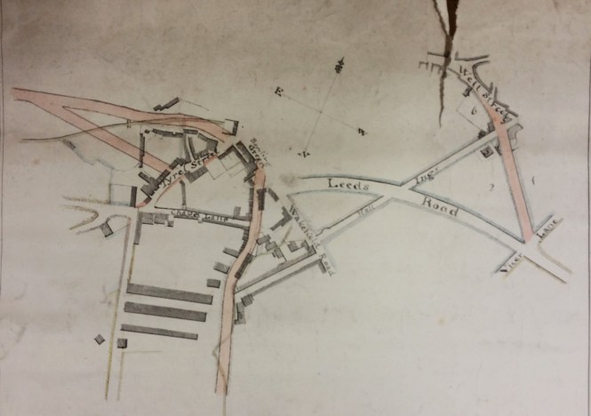
Many maps and plans were drawn prior to planned developments that may, or may not, have actually taken place. There are two maps in the Local Studies Library reserve collection which evidently were produced to display the same projected roads leaving Bradford to the south and west. Here I have reproduced the large scale plan illustrating the town centre. It is not easy to interpret and I would be very happy to have my conclusions corrected by anyone more familiar with the evolution of our road transport links.

For a start the compass points are mislabelled, although the arrow head is pointing north as it should do. The top right corner of the map would have been clearer if the parish church had been included. Church Bank is approximately the continuation of the mapped Hall Ings, although much of Hall Ings has now vanished following development. Leeds Road is in existence which dates the map to later than c.1825-30 during which period the new turnpike to Leeds was constructed by the Leeds & Halifax Turnpike Trust. Is there any other indication of date? There is no suggestion of the the line of the Lancashire & Yorkshire railway from Halifax via Low Moor (opened 1850), so the map must be earlier than the late 1840s. The map almost certainly pre-dates Bradford becoming a borough in 1847.

The short pink road joining Well Street to Vicar Lane was built and still survives. It also took the name of Well Street and, resurfaced, it is between Little Germany and the new Broadway shopping centre. The end of Wakefield Road is modern Bridge Street. The real difficulty comes with the pink track directed north from the bottom centre of the map. Is this intended to be Manchester Road? No, Manchester Road must be the straight highway ending at the junction of Tyrrel Street and Chapel Lane. The pink road seems to be following the course of the Bowling Beck and the watercourse is presumably indicated by the faint superimposed wavy line. The Bowling Beck is now culverted but I believe it does lie well east of Manchester Road. What is the unnamed linking road joining the pink track to Wakefield Road? It is too far north to be Croft Street, which survives, but it is in the right place to be Union Street which was lost in the development around the Interchange. If I am correct then the pink road itself was never constructed but the second small scale map in the LSL enables one to project its further course. It would have joined Manchester Road just before Ripleyville.

As you can see in the town centre the planned road would have reached a point marked ‘bowling green’. After a short gap another road leaves westwards from two origins. I wondered if this was approximately the track of the future Thornton Road (constructed 1829). This works if Great Horton Road is the unnamed thoroughfare making a right angle with Manchester Road, but the pink tracks seem to start too far north.  Another superimposed faint line marks, I assume, the course of the Bradford Beck in which case the ‘box’ at the end of it would then be the Soke or Queens Mill. I cannot make the pink tracks fit with any roads I know, but in any case the  street plan here changed radically around 1870 with the creation of Aldermanbury and Godwin Street. The other small scale map brings the planned road to a junction with Brick Lane after which it does continue along the line of Thornton Road as far as I can judge. If I am right the illustrated map must date from the late 1820s after the construction of Leeds Road but before that of Thornton Road.

I am on firmer ground with the ‘bowling green’. This was an inn that once stood on Bridge Street. Cudworth mentions that in the 1830s its owner was a Mrs Susannah Ward, widow of Joseph Ward, about the time then that this map was being made. On-line masonic records suggests that the Bowling Green Inn was in existence in the late eighteenth century (c.1794) and William Scruton, in Pen & Pencil Pictures of Old Bradford, pushes that date back still further into the seventeenth century. He regarded the Bowling Green as ‘the best inn of the town’. It was used by the Royal Mail and the open space in front of the inn was seemingly employed for political meetings. Copies of Scruton’s book, which mentions many other former Bradford taverns, are to be found in the Local Studies Library. Also available is Michael Hopper’s History of Communications in Bradford up to the Period of the First World War.

Derek Barker, Library Volunteer

Map of the Week: Low Moor

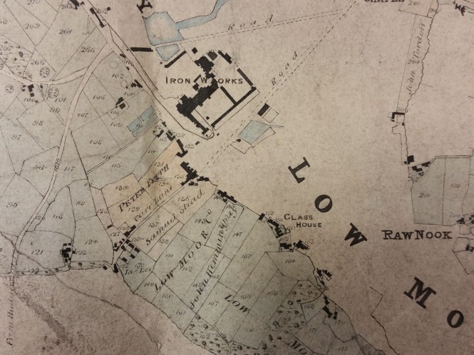
In 1828 or 1829 surveyor Joseph Fox drew a map recording the property of the Low Moor Iron Company. The West Yorkshire Archives (Bradford) have a copy of his map, generously donated by Geoff and Mary Twentyman. The donors suggest that it was kept on display at the ironworks, and it has certainly been annotated at a later date. The original map is too fragile to be handled, a common problem with old material, but images of excellent quality are available on CD-ROM. The Local Studies Library reserve map collection also has a plan, labelled North Bierley, which closely resembles the Fox map. It has deteriorated quite badly but the detail included as this week’s chosen example perfectly clear.

The same landowners are mentioned in both maps, although the script in which their names are written differs. The plan of the Low Moor Ironworks is identical in the two maps, as are most buildings included. In the top left corner of the image are a collection of roughly circular features. These represent coal or ironstone mines. It is hard to imagine now that in the eighteenth and nineteenth centuries Bradford was densely covered by mines, abandoned mine-shafts and piles of colliery waste. The Low Moor and Bowling Iron Companies smelted iron ore, obtained locally from the roof of the Black Bed coal seam, using coke made from the deeper Better Bed seam. The production of cast iron and ‘best Yorkshire wrought iron’ was extremely profitable for more than a century.

In the approximate centre of the map is the place name ‘Glass House’. This represents the site once occupied by Bradford’s only known glass-making furnace. The builder of the glass-works, known to be in existence by 1748, was Edward Rookes Leeds (1715-1788) of Royds Hall, Lord of the Manor of Wibsey.  In that era the space needed for a furnace and its attendant glass-workers was enclosed by a brick cone, and there were large underground flues. An excellent surviving example of such a cone can still be seen at Catcliffe, South Yorkshire. The Fox map in the WY Archives places a large circle at this site which could easily represent a glass cone in plan, but the map illustrated here has no such feature. Have the two map versions ‘caught’ the brick cone in the process of being demolished?

The fate of the glass works is being actively researched at present. It is possible that the works was not in active production for many years, but ‘Glass House’ long remained as a place name in Low Moor. Fox drew other maps; the LSL reserve collection contains a beautiful example showing Harden Moor, with the roads connecting Keighley and Bingley, drawn in 1830.

Derek Barker, Library Volunteer

Low Moor

Map of the Week – Goitside

My job, as a Local Studies Library volunteer, is to review the maps and plans in the reserve collection. Many of these came from Bolling Hall Museum and are now in very a fragile condition. To make a complete assessment of each map would require a far more detailed knowledge of former Bradford than I can offer. Many local historians have kindly helped me by looking at images of maps from their chosen areas. I’m very grateful to them. My intention is identify and catalogue the locality of each map or plan, and also to provide an approximate date. If you discover a mistake please never hesitate to correct me.

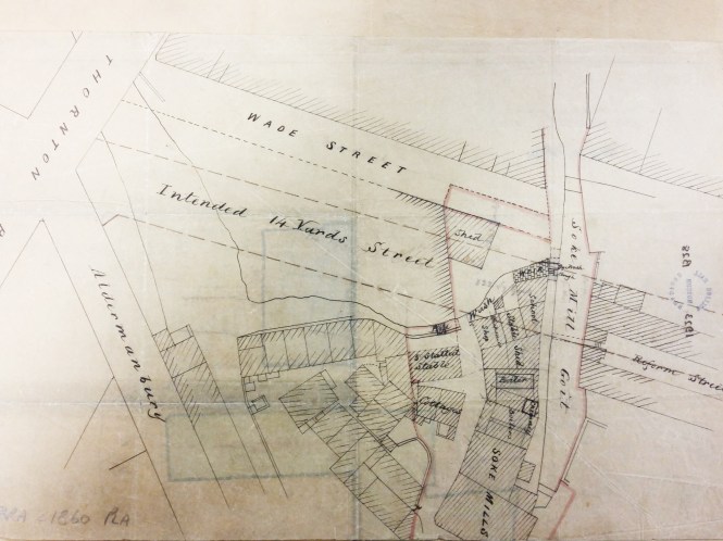
The reserve collection is inevitably selective in its portrayal of nineteenth century Bradford. Areas that were sold, developed, or involved in Corporation road-widening schemes, were likely to be surveyed. An example is provided by the accompanying map of Goitside. To explain: a goit or leet is an artificial channel which takes water from a river or beck to power a water-mill and then returns it, at a lower level, to the natural watercourse. Thornton Road was a turnpike created in 1827. The area of interest is between Westgate and Thornton Road crossed by Grattan Road (known until about 1900 as Silsbridge Lane) which runs down the slope diagonally from north-east to south-west.

In the selected map the ‘intended road’ shown being created, at the junction of Thornton Road & Aldermanbury, is modern Godwin Street. Sunbridge Road is not shown but was another modern creation. The Lord of the Manor had the medieval right to a corn-milling monopoly at the Soke Mill, which had stood above Aldermanbury for centuries. Bradford Corporation bought out this right  from Mary & Elizabeth Rawson in 1870. Soke Mill goit had taken water from the Bradford Beck and provided power for the mill; it is likely to have been a medieval creation. The cluster of buildings round the mill includes a blacksmith’s and a small school. The whole area was cleared by the 1870s.

Godwin Street is present on the 1871 Bradford Dixon & Hindle map of Bradford, but not an 1861 equivalent. The late 1860s would be an approximate date for the illustrated map. Another reserve map shows that the intention of the planners was to raise the ground surface to culvert the Goit and to finally create Godwin Street at a gradient of 1:12 well above watercourse. The tithe map suggests that the origin of the Goit was from the Bradford Beck near Water Lane. Another reserve map shows a second goit being taken from Middle Brook to service a building called Sam’s Mill.

Derek Barker

Goitside