New Map Website

Bradford Libraries are pleased to announce the launch of a new website, focusing on the hidden histories within maps and plans in the Local Studies Library

Maps and plans, especially when used in conjunction with other documents, are one of the most valuable sources of information for the local historian and geographer.

In this continuing series of regular posts, the author of our ‘Map of the Week’ feature, local historian Derek Barker, explores the hidden history within a selection of the maps and plans from the collection at Bradford Local Studies Library, focusing in particular on the 19th Century.

You can visit our new website here

Map of the Week: Shipley and the Good Templars, 1878

map of the week 032

This map originally accompanied a sale by Messrs. Best & Crewe of various freehold properties in Shipley, and elsewhere in West Yorkshire. Fortunately the sale was advertised in the Leeds Mercury on April 9th 1878 so we have a good deal of information concerning the auction lots involved. John & Joseph Denby, Worsted Manufacturers, were ‘trustees for the sale’ although it is not made clear who the original owners are or were. Not shown on the plan were three farms in Haworth, Oxenhope and Kippax that were also offered for sale.

Among the lots surveyed was Ashley Mill (then occupied by J Crowther) together with the adjacent builder’s yard occupied by John Ives. There was a timber yard, also occupied by John Ives, and a substantial dwelling called Moor House, then lived in by Fred Ives a son of John born in 1845. John Ives & Son were a firm of Shipley builders and contractors active in the late nineteenth century; the firm employed several hundred men. John Ives himself was born around 1814 and in 1871 he and his wife Grace lived at 11 Commercial Street, Shipley. Their most famous construction was Bradford Town (now City) Hall (1870-1873), but they were also one of the contracting firms who worked for Sir Titus Salt at Saltaire.

On the plan there was also a house and shop in Saltaire Road, and a vacant lot next to a complex of three quarries complete with ‘the ungotten stone therein’. Determining the owners and operators of quarries is never easy. Operators may change quite frequently and quarries might work or ‘stand’ depending on the prevailing economic situation. This plan, and the  OS map of 1889, certainly show extensive evidence of quarrying in this area. The Earl and Countess of Rosse are mentioned as neighbouring landowners on the plan. In the early 1870s their agents produced a definitive map and list of Rosse Estate quarries. The two in this immediate area were operated by John Learoyd (died 1874) and Mr E Butterfield. How you distinguished between their quarries and the stone bearing land for sale, on the ground, I am not sure.

The solicitor handling the sale was George E Mumford. Mumford’s chambers were in Piece Hall Yard, Bradford and then at Bradford Yorkshire Bank Chambers. He was solicitor for Samuel Cunliffe Lister of Manningham Mills and also secretary to the governors of Bradford Grammar School. The surveyor was William Booth Woodhead who I assume drew up this plan.

The sale was to be held at ‘The Good Templars Hall’, Shipley. The Independent Order of Good Templars (IOGT) was an American institution founded in 1851 and introduced to the UK in 1868. The Templars were described as ‘secret and mystic’ (Bradford Observer January 1873) and were evidently concerned with promoting teetotalism. Angus Holden was a noted local member. They had lodges, regalia and officers, in which respect they seemed to have resembled Freemasons who numbered Fred Ives among their number. Unlike the Masons both men and women could be members of IOGT. They had at least 16 lodges in Bradford and several thousand members. The Licensed Victuallers Protection Society considered that they needed to ‘combat the actions’ of the Good Templars who they regarded as aggressive teetotallers. How IOGT differed in outlook from the Band of Hope or the Rechabites I am not certain.

Templars Hall is often mentioned in contemporary newspapers but without a postal address being given. Where was it? In Shipley the Templars seem to have gathered in an old Primitive Chapel at Briggate, which had been bought by Edward Holden. Perhaps this was the Templars’ Hall.

There is a 25 inch OS map of 1889, that is about a decade after the sale. Ashley Mill survived and has extended into the builders yard. In fact the building is still standing today. The timber yard became a wharf. Moor House looks unchanged and in the 1881 census Fred Ives still seems to be living there; however the quarry has extended into its garden. The adjacent Shipley House, not part of this sale, has been demolished and replaced by new housing. On the other side of Moor House, Crow Gill quarry has become a small public park.


Derek Barker, Local Studies Library Volunteer


Map of the Week: A ‘village in uproar’ and the war of Bower’s dog

033 A

Recently a map introduced me to another strange unknown fragment of local history. Legal actions seem to be the explanation of several depositions in the Local Studies Library reserve collection, but after the passage of many decades it can be very difficult to establish what such actions were about, or who won, or why anyone ever thought the issues were important enough to spend a small fortune on lawyers’ fees. I am in a slightly better position with the case of Ferrand v Milligan (1845) since I believe I can provide answers to the first two questions at least, and possibly the third.

The whole map, of which this is a detail, is additionally marked ‘Plaintiff’s plan No 1’ and so it was evidently once used by Mr Ferrand or his legal team. No railway lines are marked which would suggest a date prior to 1847. In fact it closely resembles the Fox map of the area from 1830 which presumably was redrawn for the purposes of litigation. It is immediately obvious that St Ives is not in its present location. The valuable website of the Friends of St Ives confirms that this house swapped names with Harden Grange a decade or more later, in 1858. The importance of this fact is that the name ‘Harden Grange’ that was used in reports of this case, and which appears on the maps or in my account, was the building we think of today as St Ives. Aside from maps my other researches have been in the pages of contemporary local newspapers.

I am certain that the plaintiff in Ferrand v Milligan was William Busfeild Ferrand (1809-1889), landowner, magistrate, and at this time the Conservative MP for Knaresborough. He lived at Harden Grange and was a friend of Richard Oastler. William’s mother was called Sarah Ferrand. As often happened in the nineteenth century William adopted her surname in 1839 in order to receive a large estate from his maternal uncle. This bequest was ultimately transmitted through his mother when she herself died in 1854. The estate he obtained included both St Ives and Harden Grange, where he was living at the time of the action. The principle defendant is variously named as Mr Milligan or Robert Milligan: who was he? Evidently he must have had at least a modest competence to undertake the expense of litigation and the 1851 census suggests he was Robert Milligan, aged 32, of Harden Mill, worsted spinner. A man of this name had certainly been operating the water and steam powered worsted mill since 1842. There was also a Walter Milligan, aged 57 and born in Scotland, a worsted & alpaca manufacturer of 38 Myrtle Place, Bingley. I think that the two men were probably son and father. Walter Milligan & Son are listed as the proprietors of Harden Mill in many reports until 1861. I should add that Robert Milligan is quite certainly not the contemporary ‘travelling Scotchman’ and Liberal MP of that name who was also Bradford’s first Mayor. This important figure in Bradford’s history had his estate at Rawdon. If Robert Milligan of Harden Mill was indeed the man then he and William Ferrand had been acquainted in happier times. From 1842 there is a pleasant story concerning the properties of both men being visited by children from a Wesleyan Sunday School outing.

William Busfeild Ferrand does not always seem to have been popular with the editors of local newspapers. This should be taken into consideration when reading the initial account of events, published by The Bradford Observer and Halifax, Huddersfield, and Keighley Reporter under the title of ‘a village in uproar’, on 18 May 1843. It describes how a certain James Bower walked, with a terrier dog at his heels, along a road through Harden Grange Fold. There he was allegedly seized by Mr Ferrand and his servants while the terrier was ‘worried to death’ by their dogs. I’m relieved to say that, despite the title I’ve adopted, the poor terrier shed the only blood spilled in these events. Because of local indignation the whole episode was reported to Mr R Milligan, who was then Surveyor of the Highways, and he it was who insisted on the right of the public to use the road concerned.

After that things got rapidly out of hand. Robert Milligan proceeded to break down the gate that led on to the road, and to walk ostentatiously down it with a crowd looking on. Mr Ferrand, it was said, hired men to guard what he evidently considered to be his own property. If necessary his rights were to be protected ‘by force’. An emergency meeting of the ratepayers of Harden was summoned and held in Bingley churchyard. Mr Milligan’s conduct was cordially approved by the gathering. Mr Holden of Cullingworth (the future Sir Isaac Holden but then merely the manager of Townend’s Worsted Mill) proposed a motion empowering Milligan ‘to take such steps in law as may be found necessary for defending the right of the public to use the said road’. An attempt by Mr Middlebrook, a recent Highway Surveyor and friend of William Ferrand, to put any expenses involved squarely on the shoulders of Milligan, rather than the ratepayers, was defeated. The newspaper report was very partisan to the inhabitants of Harden who were praised for resisting ‘oppressive encroachments’.

The inevitable legal case was heard at York Spring Assizes in March 1844 before Judge Coltman; bizarrely William Ferrand JP MP had already been sworn in as a member of the Grand Jury for these assizes. It is clear from reports that the action was for trespass against Milligan, and others, in order to try whether the road which went through the grounds of Harden Grange was indeed a public highway or not. Mr Baines represented the defendants and examined no fewer than 31 witnesses! Mr Knowles for the plaintiff admitted that some local residents and their carts were accustomed to use the road, which ran through a considerable portion of the Harden Grange estate, but he disputed that they had a ‘right’ so to do. He explained that the road had been created in Major Ferrand’s time (c.1797) when he was a tenant, and also that William Ferrand was not actually the owner of Harden Grange but ‘entail expectant on his mother’s death’. He further stated his belief that Mr Milligan was animated in his actions by some private feeling, and finally he demanded in excess of 40 shillings damages. The unfortunate jury were then locked away from 7.00 pm until 4.00 am the following morning! With nice judgment they found that there was indeed ‘no carriage road or public foot road’ in existence, but rather than £2 or more the plaintiff (William Ferrand that is) was awarded only the derisory sum of one farthing in damages.

This was not quite the end of the matter. In another bizarre twist there was an associated criminal case, against Milligan and his servants, which saw him hauled up for ‘riot and assault’. The plaintiff and his barrister seem to have understood that Milligan honestly believed he had a right of way past Harden Grange. Mr Ferrand stated that he wished to live in ‘peace and goodwill with his neighbours’ and as a result offered no evidence against him: consequently the prosecution failed. Rather ominously Mr Milligan said that ‘nothing had occurred yet that had shown him that he was mistaken’ and so unsurprisingly, a year later, he tried to renew the action. The legal point at issue was under what circumstances the road had been repaired in Major Ferrand’s day and whether repair was at his own expense, or that of the parish. There was also some doubt over whether this evidence was really admissible: a rather a complicated point for a non-lawyer like me to follow. In any event a further action was not allowed by the court. That didn’t restrain the Bradford & Wakefield Observer who reported that ‘in this weather’ it was dangerous to cross the path of William Ferrand on the moors about Harden Grange.

033 B

The original map identified in red the trackway which, I assume, the defendant was using without permission. This extended west from the ‘Lodge’ towards Harden Grange and Cuckoo Nest. It is interesting to note that the Fox 1830 map of the roads between Bingley and Keighley also shows the thoroughfare at issue.

033 C

Finally the first OS map of the area which was surveyed around 1847, after the action and the same year that William Ferrand lost his Knaresborough seat, does not mark the trackway as a private road but scarcely shows it at all. The triumph of local landed interest over geography perhaps?

Derek Barker, Local Studies Library Volunteer


Map of the Week: Dubb Mill, Bingley

032 A

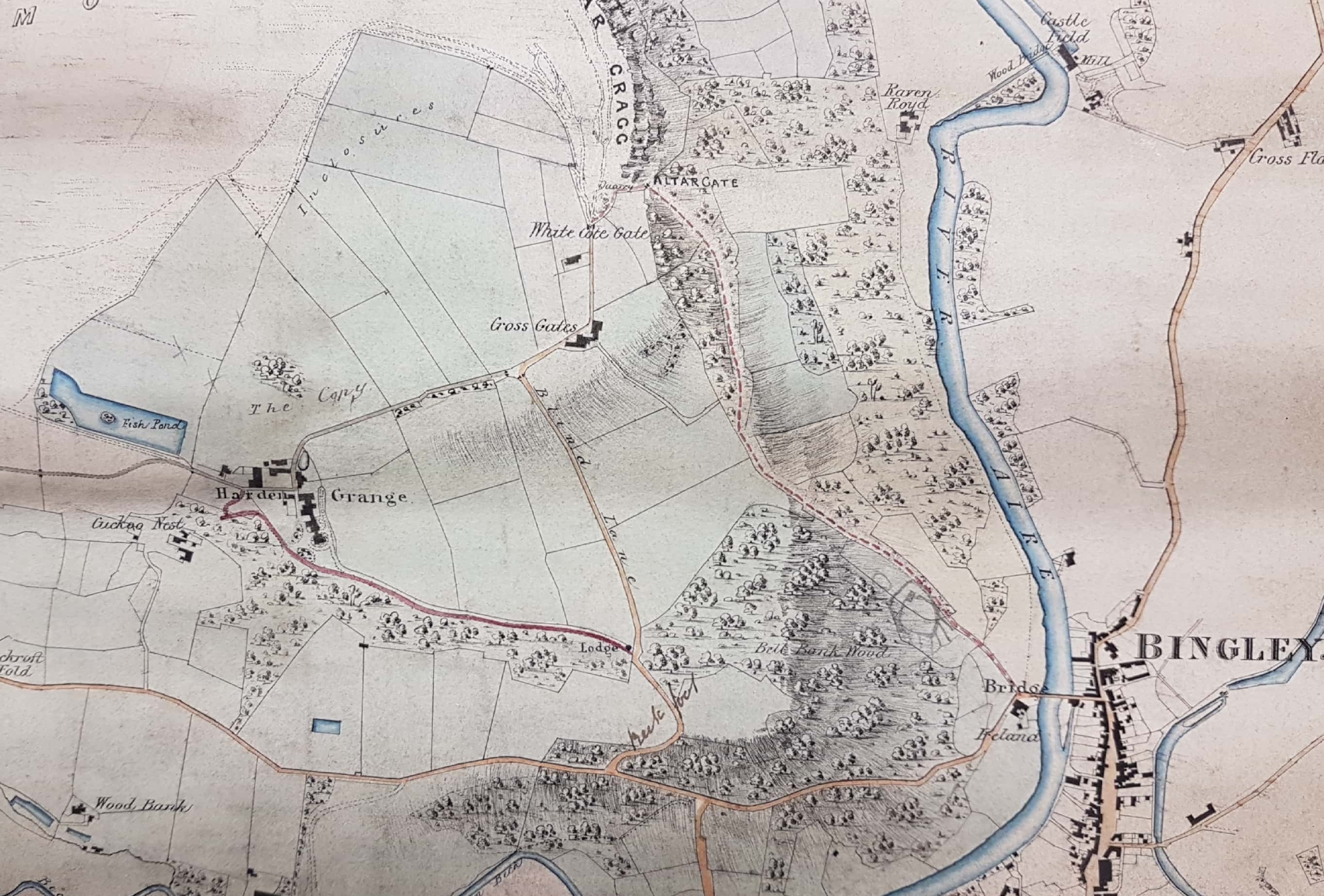
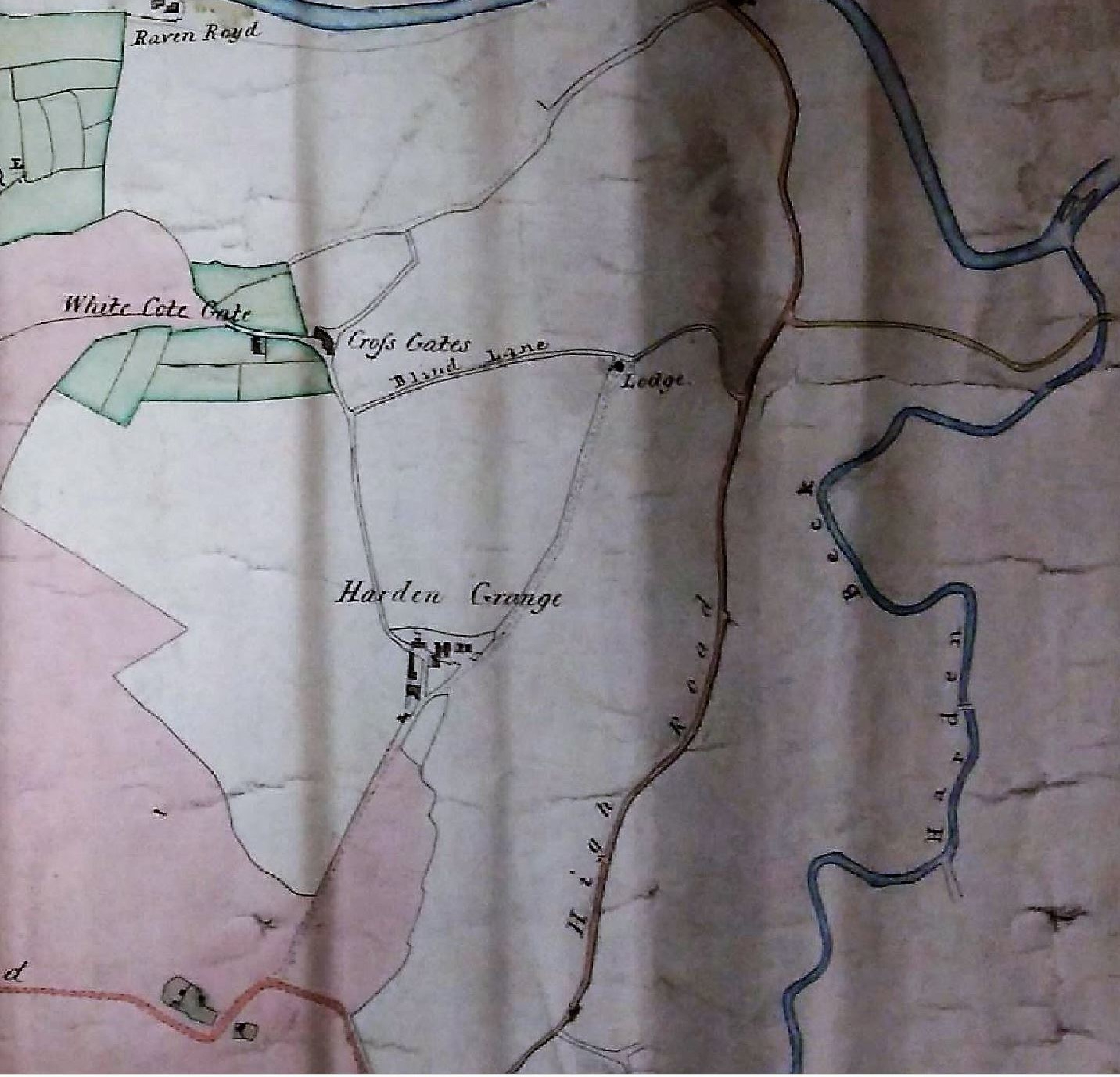
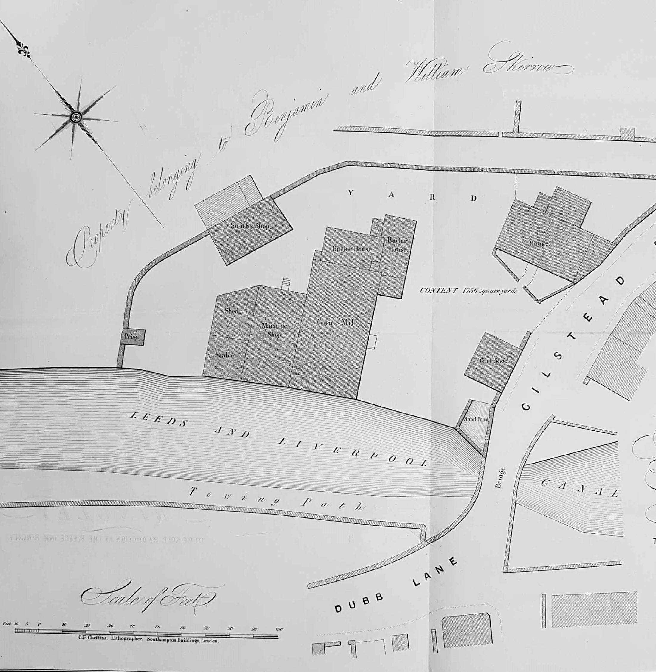
This plan features a site at Dubb Lane, Bingley adjacent to the Leeds and Liverpool canal. It was drawn up by a surveyor, E.S.Knight, in 1853 when the freehold property was to be sold by auction at the Fleece Inn. Sale plans are a significant source of the Local Studies Library’s reserve collection maps, and the buildings or property surveyed in such plans are naturally displayed in far greater detail than in contemporary Ordnance Survey maps. This complete plan should generate a LSL classification of BIN 1853 KNI and indeed there is such a card in the map index file. I cannot find the plan itself however so possibly this reserve collection example is the only copy now available. The main building is clearly labelled Dubb Mill and shows a steam powered corn mill with an adjoining residence. To reinforce this material it was not difficult to find the same auction being advertised in the Leeds Mercury. The mill was apparently three stories high and the house, stables, mechanics’ and blacksmith’s shops were also listed. The grinding was seemingly undertaken by six pairs of French stones. The benefits of the location, close to the canal and railway, are made clear. Mr E.S. Knight, was a land surveyor of Queensgate in Bradford. Particulars concerning the property are said to be obtainable from George Beanland of Great Horton. Identifying him was my first difficulty. There is a man of this name in Horton at the time of the 1861 census who is an agent but George Beanland of Messrs. George, Joseph and John Beanland, corn and flour dealers of Beckside, is perhaps more likely to be the man involved. Unfortunately no owner or vendor of the corn mill is mentioned by name but at the time of the sale the yearly tenants are Messrs William England & Son, and the under-tenant one Jonathan Cryer. According to the London Gazette, in the following year the partnership of William England & Son of Bingley was dissolved and the assets were transferred to brothers Abraham and William England. Interestingly the newspaper advertisement promotes the idea of converting the corn mill to cotton or worsted spinning, which is very pertinent to my subsequent analysis.

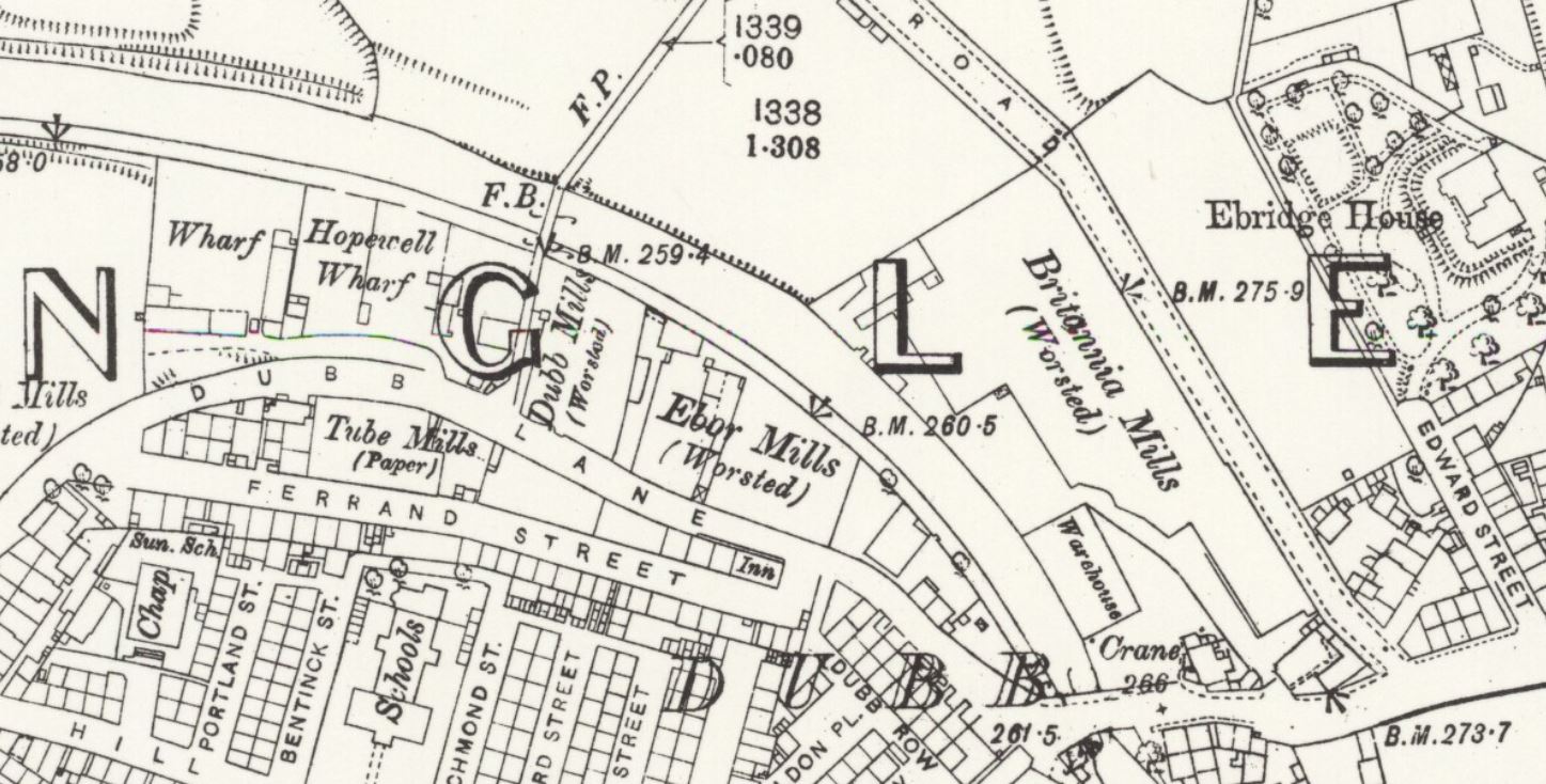
I think that we can be sure of the mill’s earliest possible date of construction since it is so closely aligned on the canal. This canal section was completed by 1774. The shape of the site, and its position adjacent to a canal bridge, makes it easy to identify in other maps even if the buildings are unnamed. There is no doubt that the mill is present in the earliest map available to me, the 1819 Fox plan of Bingley, but if Dubb Mill was always powered in the same way it cannot have been as old as the canal since the first steam powered corn mill was only built in Bristol five years after the canal was opened. Moreover the 1819 building block plan does not seem to allow for the engine and boiler house, yet what other power supply could there have been? I should say that it was by no means unknown for corn mills to be converted to textile mills, although was rare for conversions to move in the opposite direction.  Some 35 years after the mill sale, in the OS 25 inch map of 1889, there is simply a warehouse at this situation which appears to be part of Britannia Mills. At that date, if you crossed the bridge and walked along the towpath on the opposite side of the canal in the direction of Bingley town centre, you would pass Ebor Mills (worsted) to reach a second worsted mill by then itself called Dubb Mill.

032 B

A few years before our plan, in the first OS map (surveyed in the late 1840s), the older Dubb Mill is naturally present although no indication is given of its function. At the position where in 1889 there was situated what I might call ‘new’ Dubb Mill there are three buildings labelled as cotton mills. A later map suggests that these units were also called Dubb Mills, which must surely have caused confusion. It may come as a surprise that cotton is being processed in an area so strongly associated with worsteds but in fact Keighley was a centre for the cotton industry in the early 19th century.

Establishing the history and ownership of the Dubb corn mill up to the time of its 1853 sale was the problem I set myself. An obvious source of information was Harry Speight (Chronicles and Stories of Old Bingley, 1898). He mentions a man called Robert Ellis, who seems to have been the brother of Bradford Quaker James Ellis. Robert took ‘the old Dubb corn mill’ about 1818 and was joined by James in 1822. Is this the same Quaker James Ellis who was so active in famine relief in Connemara in the late 1840s? Probably: Ellis & Priestman were partners in corn milling at Queen’s Mill, Mill Bank, Bradford which I believe vanished when Sunbridge Road was constructed. Speight also describes the construction of an ‘early worsted mill’ with an attached residence by Joseph and Samuel Moulding. This would certainly be an accurate description of the building on our plan in all respects except for the type of mill involved.

Speight wrote that about 1825 William Anderton took part of this mill but soon began building premises of his own in Dubb Lane for wool combing and spinning. These later buildings, he wrote, were later occupied by ‘the Ellises’ who raised and enlarged them for cotton spinning, and a new mill was built on the opposite side of the road which for some years (in the late 19th century this would be) was occupied by Samuel Rushforth JP. We seem then to have four mills to explain: the old Dubb corn mill, an early worsted mill constructed by the Mouldings, the Anderton-Ellis mill, and the Rushworth new mill which is perhaps the ‘new’ Dubb Mill. I’m not claiming that they all were in in operation simultaneously, nor that they retained one function during the full periods of their existence. I cannot see that the brothers Ellis took on our corn mill since Speight describes their corn mill as ‘old’ in 1818 when ours was spanking new. If our mill was constructed for textile manufacturing is it likely that the building would subsequently have returned totally to grain processing? The best evidence that touches on this point is the 1865 Smith Gotthardt plan of Bingley.


032 C

The detail is inverted but allowing for this you can clearly see that twelve years after the 1853 sale our mill is still present and is unquestionably labelled as Moulding Mill and the cotton processing units as Dubb Mill. It seems likely then that Speight’s second statement is correct and some members of the Ellis family actually moved to the Anderton worsted mill. I tried to obtain further information about these mills from the on-line 19th century copies of the Bradford Observer and Leeds Mercury. Unfortunately many entries and advertisements simply mention ‘commodious mills at Dubb’, providing neither mill name nor owner. Nor did trade directories provide simple answers. The 1822 Baines directory at least suggested that several characters in our story have an interest in the licensed trade: J & S Moulding were at the Shoulder of Mutton, Bingley and W Anderton at the Pack Horse, Cullingworth. I know that Mr William Anderton (1793-1884) certainly came from Cullingworth, even if he wasn’t the publican mentioned in my last sentence. His Bingley enterprise features in the Factories Inquiry Commission of 1834. His premises were described as steam powered and undertaking worsted yarn spinning. There were 56 people employed (16 under 12 years of age) which seems reasonable for a small mill. The employees’ hours of work were 6 am-7.30 pm. The machinery was stopped for a dinner break of 45 minutes at noon. There were six holidays per year (8 days total) when whole factory ‘stood’ and no wages were paid. Anderton’s mill is described as Dubb Mill, Bingley ‘a mill erected in 1819’ so I am reasonably sure this is the mill in our plan.

Inconveniently 1842 White’s Leeds & Clothing District directory does not record any corn millers working in Dubb, but William Anderton and Joseph Moulding are given separate entries as worsted spinners & manufacturers. Helpfully there is a small item in the Bradford Observer from 1848 to the effect that asignees of John Robinson, a Moulding tenant, were trying to sell power looms and machinery but this attempted sale would be prevented by ‘executors of the late Joseph Moulding’. It seems unlikely that such a building would have been re-equipped as a corn mill before being sold five years later but I cannot think of another explanation that fits. In 1843 a Joseph Moulding (1775-1843) of Dubb was buried at Bingley Parish Church.

Meanwhile life at William Anderton’s mill was not without incident. In 1850 the Bradford Observer recorded an assault on Fanny Broadly which arose from a ‘dispute over bobbins’ at Dubb. In the census of 1851 William Anderton is living at Wellington House, Wellington Street. He describes himself as a worsted spinner & manufacturer employing 240 males 265 females. This sounds like a reasonably large operation and must surely indicate new premises. Remarkably 30 years later William Anderton was still alive, at the age of 88, and living with his daughter Mary and son in law John Brigg (another textile man) at Broomfield House, Keighley. As I have mentioned Anderton’s mills were taken over by the Ellises of Castlefields Mill for cotton spinning, and their operation presumably represents the cotton mills present on the first OS map of the area. At the end of the century the name Dubb Mill is associated with Samuel Rushworth JP, woolspinner and manufacturer. Rushworth was a famous teetotaller who died in 1896 aged 52. His mill must have been the new construction mentioned by Speight. I assume that this is the new Dubb Mill on the 1889 OS map.

I have tried to pull all this together. There must have been an old corn mill in Bingley, possibly close enough to the river Aire to use water as a power source. Castlefields Mill was constructed in the late 18th century and by 1805 was run by Lister Ellis who stayed until 1829. In 1818-19 Messrs Joseph & Samuel Moulding constructed the first Dubb Mill. If it was a worsted mill hand-combing and weaving seem quite likely at that period. William Anderton may have later been involved with this building but by 1825 he was building his own mill nearby in Dibb Lane for wool-combing and spinning. William and James Ellis took this over for cotton spinning and Anderton must have used other premises. In the later 19th century Samuel Rushforth, who had started life working for Anderton, adapted the cotton mills and rebuilt a new Dubb Mill. My guess is that once steam power was introduced at the old Dubb mill it could function either as a corn mill or worsted mill and performed as both at various times. It clearly survived until 1865 but was later converted into warehouse, or rebuilt in that capacity by 1889. I know that interest in local history is very strong in Bingley and I’m hopeful that somebody will be able to put me right on aspects of this complicated story especially the matter of how many men called Ellis were there, and what exactly were their relationships.

Derek Barker, Local Studies Library volunteer

Further Reading

George Ingle, Yorkshire Cotton: the Yorkshire Cotton Industry, 1780-1835: Carnegie Publishing, 1997.
A very readable introduction although there is no mention of any mills in Dubb.

Colum Giles & Ian H Goodall, Yorkshire Textile Mills 1770-1930: RCHME & WYAS, 1992.
A beautifully illustrated general guide but one that does not answer any of my questions.


Map of the week: Boldshay Hall Estate, Barkerend

Fig 031 A


It is always an exciting moment when an important two hundred year old map, which does not appear to represent a copy of one already in the publicly accessible collection, turns up among the Local Studies Library’s reserve material.  The title of this map indicates that it produced for Colonel Thomas George Fitzgerald, who was a large landowner in Bradford until his death in the mid-nineteenth century. Local Studies has plans of his holdings elsewhere in the city, but no other copy of this plan of Boldshay Hall as far as I can see. The West Yorkshire Archives also has many documents relating to the estate.

Physically the map is a tinted, rolled, estate plan but it is dusty, in poor condition, and needed some repair before it could be handled safely. It was found in a group that seem to have come from Bradford Council. The next map was a post-war plan of Bradford’s twinned city Mönchengladbach, more recent by about 140 years! The unnamed building you can see a little south east of Boldshay is Miry Shay (or Miryshay) an older seventeenth century house. This has long been demolished but in the early nineteenth century had been the property of JH (John Henry) Smyth MP (1780-1822) whose family had owned it, and the Bradford Soke Mill, for generations. Smyth had died before the map was surveyed, and hence is referred to as ‘late’. The West Yorkshire Archives have a good deal of information about the Smyth family too. By the time of the 1852 Ordnance Survey map there was a large colliery just south of Miry Shay called Bunkers Hill. The land ownership in this area is made clearer by a second, later, LSL map which also illustrates that the name Bunkers Hill was in fact applied to a series of collieries along Barkerend Road.  The ‘Col. Smyth’ in this map is John George Smyth (1815-1869) MP for York and Colonel of the 2nd West Yorkshire Militia who lived at Heath Hall, Wakefield. His land holdings north of Barkerend Road are now a substantial part of Bradford Moor Golf Club.


Fig 031 B

The original Boldshay Hall Estate plan is dated 1828 and was drawn by Joseph Smith, of whom I will say more later. Boldshay Hall itself was built circa 1740 and at this early period was associated with the name of Samuel Hemingway and his son Henry Hemingway, who were both lawyers. The estate itself is presumed to be far older. Remarkably the hall still exists on Byron Street, surrounded by Victorian housing, and is Grade II listed. The gardens, fields, and coal mines which once enclosed it have long ago vanished completely.

As you would expect some previous owners of this historic building are described by William Scruton in Pen & Pencil Buildings of Old Bradford, and of course by William Cudworth. The estate passed to the Lister family of Horton Hall since Samuel Lister’s sister, Elizabeth Lister, had married Henry Hemingway. Their daughter, and Samuel Lister’s niece, Mary Hemingway married a Dr James Crowther MD of Leeds. After the death of Samuel Lister, and his second wife, Dr and Mrs Crowther inherited all the Lister estates and in due course their own daughter Elizabeth Crowther (1788-1838) became the Mrs Fitzgerald of the map’s title. Colonel Fitzgerald is Thomas George Fitzgerald, of Turlough, Ireland (1778-1850) who in 1819 had taken Elizabeth Crowther as his second wife at St George’s Hanover Square. Fitzgerald’s first wife also had a strong Bradford connection. Ten years earlier, in 1809 at St Peter’s, he had married Delia (1780-1817), daughter of Joshua Field, of Heaton Hall, and sister of John Wilmer Field. Two daughters died young but they had one son who took over their Irish estates. I should really like to know how Colonel Fitzgerald kept meeting Bradford heiresses and winning their hearts.

Fig 031 D

The hall itself is the large building in the centre of the group. I assume the rest are stables, farm buildings and coach houses; note the presence of an ice house. The agent for the estate, and other Fitzgerald properties, was Joseph Smith. Joseph Smith must have surveyed this map. He was succeeded by his son George Belk Smith who had designed the Bradford – Eccleshill turnpike in 1826. There are pencil annotations which are hard to read but seem, at least in part, to be records of the years in which certain parcels of land were acquired for the estate. I would like to know how long the Fitzgeralds lived at Boldshay Hall. After the death of Colonel Fitzgerald the estate passed to his son Major Henry Thomas George Fitzgerald (1820-1890) who had been born and baptised in Bradford but probably didn’t live here; his address is usually given at Maperton House, Somerset, which the Fitzgeralds also owned. Baines directory of 1822 confirms that Colonel Fitzgerald was in residence at that date but by the time Fitzgerald died in 1850 the Leeds Mercury recorded that he was ‘formerly of Boldshay Hall’. The 1828 map itself includes a list of tenants with their holdings, but nobody is leasing the hall where presumably, six years after the directory was published, the family still lived. It would appear likely that Colonel and Mrs Fitzgerald moved to Maperton House in the late 1820s. Could the resultant need for records of their local land holdings have been the reason that the map was originally created?

Interestingly around this time Boldshay Gardens became a place of public resort. The fact that they were no longer open for this purpose was formally announced in the Leeds Mercury in 1839. As I have mentioned before I am not a family historian and I am slightly puzzled by exactly who lived at Boldshay Hall after the Fitzgeralds. One of the map’s listed tenants is James Cousen. A man of this name is a partner in Rawson, Cousen & Co who were coal masters. This company owned the various Bunkers Hill collieries by the 1830s. His son, another James, (of Cousen, Thackrey & Co, stone-merchants of the canal basin) was given the address of ‘Boldshay’ in the press announcement issued when he died in 1830.  Possibly Boldshay Hall was subdivided since a local merchant named John Mann (1808-1845) was also giving Boldshay as his address by 1834. According to the Bradford Observer the same man won a prize for his lettuce at the Bradford Grand Floral & Horticultural Society in 1841. John Mann died in 1845 at the early age of 37. Probably James Cousen and John Mann were related. One family historian gives James Cousen’s second wife the name of Elizabeth Mann.  James Cousen senior still lived at the hall when he died at the age of 83 in 1844. I have also seen James Cousen’s name linked with Miry Shay although the only contemporary resident of this house I am certain of from press announcements is a Joseph Dalby, farmer, who died there in 1834.

The 1841 census makes the situation slightly clearer. At Boldshay Hall live John Mann (30) and wife Anne (who was to survive him by fifty years), two children and four servants. Andrew Newell, a gardener, lives at Boldshay Gardens. Miry Shay is more complicated. James Cousen, coal merchant, and his wife Elizabeth are certainly resident, but so also are a collection of coal miners, agricultural labourers, worsted weavers. and assorted descendants of the Dalbys. Understandably I have a personal weakness for Barkerend so exploring this map has been a real pleasure even if I have not found all the answers.

Derek Barker, Local Studies Library Volunteer

Map of the week: A track into history

I’m not really a railway enthusiast so I must start with an apology to those readers who are, and say that I would welcome your guidance. I don’t find the early history of Bradford’s rail links an easy topic since the companies involved seem to change their names, and move the location of their stations, quite frequently. Naturally the creation of early railway lines generated maps and plans, many of which have survived. Even here I have a problem since tracks appear on maps which are notionally of an earlier date. Despite these difficulties I want to describe the early lines entering Bradford from the south because of  the interesting light they shed on the city’s industrial past.

Map of the Week 30 A

The first image is a detail from the 1852 Ordnance Survey map. It shows Bowling junction, although this is not named. Two, seemingly single, rail tracks, are mapped. The first is the Lancashire and Yorkshire Railway line which connected Halifax to Bradford, and its terminus Drake Street (later Exchange) Station which opened in 1850. The second line moving off to the right went from Bowling junction to Leeds, via Laisterdyke, and was opened a few years later in 1854. It was operated by the same company and, I presume, allowed trains to travel from Leeds to Halifax direct, by-passing Bradford completely. The track no longer exists but the line is visible on aerial photographs.

I am interested that at the junction a ‘limestone quarry’ is mapped. Limestone strata do not reach the surface in the city area but there was nonetheless an early lime-burning industry based on the extraction of boulders from glacial moraines in the Aire valley. Boulder pits were certainly established in Bingley by the early seventeenth century. It looks as if glacial erratic limestone boulders were found elsewhere, being exploited in the same way. In this case the digging of a railway cutting presumably exposed the valuable mineral. Plausibly these boulders were taken to the nearby Bowling Iron Company where crushed lime was used as a flux in iron smelting. Slightly further north is Spring Wood. The name has almost certainly nothing whatever to do with a water supply. ‘Spring’ was applied to a tree that had been cut off at ground level for coppicing. So Spring Wood was presumably an area of old coppice woodland. William Cudworth records that there was once also a Springwood Coal Pit, but the wood itself soon disappears from maps.

Map of the Week 30 B

The next plan is from the Local Studies Library reserve collection. If you imagine it turned 90º  clockwise it is clearly the same view as before. You can easily identify the two railway tracks and also the Bowling Dye works. The name of the company involved here is West Riding Union Railway. As I understand it this title was only employed for a brief period around 1845-47. This and other evidence suggests that this map is a few years earlier than that of the OS map we have examined. This map shows the Bowling Iron Company colliery tramway very clearly. This took coal to the Bowling Depot on Queens Street where I assume it was available to local merchants. The Bowling Dye Works and the Bowling New Dye House were both parts of the Ripley family enterprises (Edward Ripley & Co). What are obviously missing are the large reservoir and dye pits which are such a prominent feature in the OS map. When were these created? The Bradford Observer reports a large sale of land in this area, including that piece accommodating the Dye Works, in 1850. The vendor isn’t stated but might well be the Bowling Iron Company. Probably the dye works boss, the famous Sir Wm. Henry Ripley, purchased land at this time to allow for the expansion of his business and the assurance of adequate soft water supplies, which included a reservoir. Cudworth records a 100 acre purchase by the Ripley company and also states that a contractor called Samuel Pearson constructed reservoirs for Bowling Dye Works and Bowling Iron Works at a date ‘early in the fifties’. We shall hear more of Samuel Pearson shortly. Marked on this map are marked a variety of planned new streets. Were these streets ever constructed? Presumably not. After 1863-64 Ripleyville, consisting of 200 houses with schools, was constructed by Sir Henry but the alignment of these streets on the 1887 borough map looks quite different.

Map of the Week 30 C

This third map shows an area slightly further north. There have been additional train track developments. The Great Northern Railway had opened its service to Leeds from Adolphus Street station in 1854 but the rival Midland Railway service, via Shipley, ended at a station more convenient to the town centre depriving GNR of customers. In consequence, around 1867, a track loop was constructed connecting the GNR line to the L&Y track at Mill Lane junction and allowing passengers from Leeds access to Exchange Station. Nearby St Dunstan’s passenger transfer station was also opened. The loop is clearly visible on the map north of Ripleyville. In describing the work involved in taking the GNR railway line from the Exchange Station towards Leeds, Horace Hird (Bradford in History, 1968) again mentions the activities of Samuel Pearson & Son who took over responsibility for the material excavated from the necessary cutting. The cutting spoil created a ‘great mound’ and for 15 years 60 men were employed making drain pipes, chimney pots and bricks from this material. Their Broomfield brick works is clearly indicated on the map above the loop. The line seen curving away to the left edge of the map, opposite the brick works, services a series of coal drops which are still visible, in a ruinous state, off Mill Lane today.

Samuel Pearson was a Cleckheaton brick-maker who founded a contracting dynasty. His contracting business started in Silver Street, off Tabbs Lane, Scholes, in 1856. By 1860-63 Messrs. S. Pearson & Son were established at the Broomfield Works, Mill Lane (near St Dunstan’s) for the manufacture of building bricks, sanitary tubes and terracotta goods. The works can be identified on the 1871 map of Bradford but closed shortly before the 1887 map was published, the ‘spoil bank’ being exhausted. The site is described as a ‘disused brick-works’ by the time of the 1895 OS map. Within a generation Pearson’s had became an international contractor and was particularly associated with Mexico during the dictatorship of Porfirio Diaz. Canals, railways and oil were among the company’s many interests. After being created a baronet Samuel Pearson’s grandson, Weetman Pearson, became the first Viscount Cowdray in 1917. The family seat became Cowdray House and park, near Midhurst in West Sussex.

map-of-the-week-30-d.jpg

For the final plan I return to the LSL Reserve Collection. Essentially it shows the same area as the last. The plan is undated but the railway companies have their pre-nationalisation names, so it is earlier than 1948. Wakefield Road is referred to as the A650 and local historian Maggie Fleming suggests that this nomenclature makes the plan later than 1920. St Dunstan’s Station is still present, and in fact had another thirty years of life before closing in 1952. The site of Broomfield brick works is blank, and is today a car park. The purpose of this plan seems to have been to show the course of a new road joining Bolling Road to Upper Castle Street. This is another thoroughfare that was never constructed.


Derek Barker, Local Studies Library Volunteer


Map of the week: Old Frizinghall

Bradford local historians are most fortunate in having the Local Studies Library and the West Yorkshire Archives (Bradford) under the same roof, each with helpful and dedicated staff. To illustrate the value of this I shall trace the history of a single building starting with the Local Studies Library reserve map collection which provides a detailed plan of the area between Bradford and Shipley. The plan is completely unlabelled but field boundaries and properties are meticulously drawn. A detail is included here which shows the canal and Bradford Beck at the bottom. A continuous line (red in the original) near the map centre must represent the railway to be opened by the Leeds & Bradford (later Midland) Railway Company in 1846. The discontinuous lines lines on either side were presumably an estimate of the land needed to be acquired by the company. The date of the map would be the early 1840s. From comparison with the first OS map of the area, surveyed a few years later, the track did follow exactly this route.

Map of the Week 029 A

You would need to know this area very intimately to recognise the hamlet in the upper centre of the map as Frizinghall. This is now considered to be part of Heaton, which was not incorporated into the Borough of Bradford until 1882. To orientate yourself imagine you are standing in Bolton Woods: the direction of Bradford is to the left and Shipley to the right. The course of the beck has since been straightened and between it and the railway is the modern Canal Road, at roughly the position of the lower interrupted line. The thoroughfare drawn crossing the canal is Gaisby Lane. The next plan is a detail from a lovely Frizinghall map which is approximately contemporary with the first image. It is available in the LSL main collection.

Map of the Week 029 B

There was to be extensive house building over the next 50 years, probably after Frizinghall train station was opened in 1875, but many features on this map are still visible today. The three buildings in the lower third certainly still exist. The only one with public access fronts the turnpike road. This is the Black Swan public house; the triangle of land on which it sits was once called Swan Hill and is well above road level. The Black Swan must predate even this map by several centuries and is well worth a visit. From its car park the housing which looks like a laterally inverted L is also visible. The third building in the cluster is a private house then called the Old Hall.

 My personal favourite is the building in the middle of the blue coloured land opposite the ‘turn’ of turnpike; this is still easily visible from the road. Although latterly called ‘The Old Barn’ when it was a pub-restaurant, the property was known as ‘The Poplars’ for much of the twentieth century. Earlier than that it was ‘Carr Syke Farm’ or ‘Lower Carr Syke Farm’. The Carr Syke was a watercourse, the name deriving from the Norse meaning ‘the stream in the marshy ground’. In the late eighteenth century the Carr Syke Farm seems to have formed part of the estate of Benjamin Hird of Frizinghall which was sold to a Dr Joshua Walker of Leeds in 1795. The estate passed to Dr Walker’s daughter Margaret, and then by marriage to a well-known Quaker, William Leatham of Hemsworth Hall, Wakefield. I believe it was owned by his family for the next 80 years. In 1883 the property was then sold to Bradford Corporation by William Henry Leatham and others. Two years later the property was purchased from Bradford Corporation by the Clockhouse Estate who retained it well into the twentieth century. Much of this portion of the estate eventually became the location of Bradford Boys Grammar School.

If you wish to learn even more a distinguished local historian, Lillian Robinson, wrote a detailed account of Frizinghall (the place of her birth) in the years 1973-75. This work does not seem to have been published but typescript copies are available in the Library (B942 ROB). The notes on which this work is based are available in the Archives (WYB140) and are as useful as the completed work itself. Earlier still M. Blundell Heynemann had written an account for The Heaton Review in 1931. She had this to say: ‘on the right, down a paved path, is the entrance to the Poplars, the residence of Mr Wilkinson, the Clock House Estate Agent. A farm, now demolished, formerly stood facing the road and only the old barn and stables still remain. It was farmed by a Mr Greenwood who went there in 1877’. The Bradford historian Cudworth clearly mentions, without directly naming, Lower Carr Syke Farm because of its association with William Wilson who once leased it: ‘another old homestead at Frizinghall, enclosed in its own grounds, was for some time the residence of a most exemplary Quaker family, named Wilson, originally of Esholt. One of the members of this interesting family, named Willie or ‘Quaker’ Wilson (1767-1849), enjoyed a reputation throughout the entire kingdom for his many eminent qualities as a philanthropist.’  Wilson was apparently able to retire at fifty years of age (that is in 1817) with a fortune of many thousands of pounds. This he methodically gave away to the poor over the next 30 years. He died, much lamented, in November 1849, aged 82, and his remains were interred in the Friends’ burial-ground, Bradford.

With the next two images the Archives comes into its own. Both are rotated 90° anti-clockwise from the first two. We have moved back a generation to Joshua Walker Sr. (1713-1801) who was also a Bradford Quaker, and an apothecary; he seems to have been an amateur architectural enthusiast who drew many house plans. It was his son, Dr Joshua Walker (1746-1817) physician at Leeds Infirmary, who had bought the Carr Syke estate. One of his father’s undated plans, available in the Archives, is labelled ‘Lister Patience’s Farm’; Heaton & Manningham’. The field boundary pattern fits Lower Carr Syke Farm. In this plan the present building would appear to be originally a barn which has two cottages (now missing) in front of it.

Map of the Week 029 C 

Another of Joshua Walker’s productions, WYA(B) 85D90 plan 45, is described as showing a ‘laithe house and yards’. There’s not much doubt that Lower Carr Syke Farm would have appeared very much like this when first arranged for human habitation. It is quite possible that the drawing does actually represent Lower Carr Syke Farm itself. The two cottage-like structures in the foreground could easily be those marked on the map of ‘Lister Patience’s farm’. I have not been able to trace ‘Lister Patience’, nor Patience Lister which sounds a more probable name. Can anyone help?

Map of the Week 029 D


Derek Barker, Local Studies Library volunteer

Map of the Week: Toads and Chapels

In the 170 years since Bradford became a borough, in 1847, its centre has changed almost beyond recognition. New buildings have been erected and old ones demolished. The Bradford Beck has progressively vanished underground into culverts.  New roads have been created (Sunbridge Road being a good example), while others have been repositioned, lengthened, or have disappeared entirely. Change has been a continuous process but it was accelerated in the 1960s when there was a wholesale city centre redevelopment associated with the name of SG Wardley, the City surveyor and engineer. I should like to recount something of this story by describing the events that befell a thoroughfare called Chapel Lane.

Map of the Week 028 A Final

Image 1

I thought I had made a good start with the this first plan, which is widely reproduced and purports to date from 1800. Here it is easy to see the acute angle made by the Turls (Tyrrel Street) and Chapel Lane/Toad Lane. Toad Lane is an odd name but it is not unique; there are, or were, Toad Lanes in Bingley, Newark and Rochdale. Possibly the name is a corruption of ‘t’owld’ lane: certainly in Bradford the lane is drawn, but not named, on a map as early as c1722. On the above plan building (3) is the Unitarian Chapel which was certainly in existence at this time. An existing town hall is numbered (35) on the map but there is a small puzzle here. The Act of Parliament that appointed commissioners for levying rates, and improving Bradford roads and lighting, was only passed in 1805 and no town hall was to be built for decades. I am very obliged to local historian Kieran Wilkinson who explained this apparent anomaly by telling me that the map of 1800 is not contemporary but was a creation of the late nineteenth century, and marked places both where important local buildings were in 1800, and would be in the future. Let us instead look at a detail from a map that is believed to be contemporary, that of 1802, which is available in the Local Studies Library.

Map of the Week 028 B Final

Image 2

I do not think that there is much doubt that the second plan was the origin of the first, but there are some difficulties here too. Firstly Toad Lane is not mentioned. Kieran tells me that the shortening of Toad Lane, to that unnamed portion that leaves Chapel Lane at a right angle to join Bowling Green, happened in August 1804. The town’s board of commissioners changed both it and the names of a number of other roads in the town (Bank Street, Bridge Street, Market Street and Well Street being introduced as names then). Secondly although there is a Chapel Lane there is no obvious chapel. In his Pen & Pencil Pictures of Old Bradford William Scruton gives a full account of this building, originally constructed in 1717. Much of its material came from Howley Hall, Batley and the land on which it stood was donated by the Sharp family of Horton Hall. The names was originally the Toad Lane Presbyterian Chapel. The old chapel lasted about 150 years and for much of this time was located ‘amid green fields’. The chapel was replaced by a larger more modern structure in 1869, and finally demolished a century later. The most notable figure to be connected with the institution was Rev. Joseph Dawson who is closely associated with the exploitation of the mineral wealth of Low Moor. One possible explanation of the difference between the two maps is that the 1800 marks the position of the 1869 rebuild whereas in 1802 the chapel formed part of the block drawn immediately south of the first section of Chapel Lane. Unfortunately this simple explanation cannot be correct. A chapel, but with no denomination provided, is mapped here c1722, which is in accordance with Scruton’s statement, and the following detail from a map of 1825, surveyed by L Atkinson, clearly illustrates the same building. Here the building numbered (8) is identified on the map rubric as the Unitarian Chapel.

Map of the Week 028 C Final

Image 3

I have already mention the Bradford commissioners. This early embryo town council are said to have originally met at the Bull’s Head Inn, Westgate. At the first meeting according to historian Horace Hird, Lord Mayor (1951-52), the commissioners drew up that list of Bradford roads. The same commissioners moved to the ‘Station House’ in Swaine Street after it was erected in 1838. They did not change landlord since the Bull’s Head and the Station House were both built on land leased from Rev. Godfrey Wright who regularly features in this articles.  The final building I want to mention is the Bowling Green Hotel, which completes what I shall call ‘the central triangle’. This hotel was located at the end of Bridge Street. Cudworth mentions that in the 1830s its owner was a Mrs Susannah Ward, widow of Joseph Ward. William Scruton pushes the Bowling Green’s existence still further back into the seventeenth century. He regarded it as ‘the best inn of the town’. It was used by the Royal Mail and the open space in front of the inn, which presumably was once a bowling green, came to be employed for political meetings. The road names remain unchanged until the mid-nineteenth century, which is represented by the next map from the Local Studies Library reserve collection.

Map of the Week 028 D Final

Image 4

It is perfectly clear that there has been extensive construction in the central triangle.  The Bradford Observer (1844) observed that the premises of DH Smith at the corner of Toad Lane were ‘striking and elegant’. Elsewhere a ‘Smith’s Tavern and Beer-house’ is noted which I assume was the same building. Other developments were evidently far from elegant. In 1847 the Poor Law Commissioners considered Chapel Lane a possible site for a ‘vagrants yard’, and in 1855 a ton and a half of ‘vile bones’ were removed from the premises of John Boyd. The Lund’s 1856 Directory of Bradford lists John Boyd as a ‘rag dealer’. The same source gives Rev. JH Ryland as the non-resident minister at the chapel. There is also an architects’ partnership (Stott & Illingworth) and a painter (John Edwards), but otherwise the Chapel Lane residents are all tradesmen: plumbers, hair dressers, bootmakers, saddlers, pawnbrokers and so forth. Was the ‘Old Foundry’ (Cliff’s Foundry) drawn on the second map still functioning in the town centre? According to Hird it was.

The new unnamed cut-through joining Chapel Lane and Tyrrel Street  is Bower Gate. Toad Lane makes an acute angle with Norfolk Street. Kieran Wilkinson tells me that Toad Lane was ‘stopped up’ in 1869 to assist with the subsequent Town Hall development. The Bradford Daily Telegraph of 10 September 1873 recalled that Toad Lane was a ‘narrow passage… immediately behind Garth’s warehouse’. According to the Bradford Observer of 17 March 1869, the width of Toad Lane was only three and a half yards. The next development, which I have already hinted at, represented a huge change. Bradford Borough Council decided that a purpose built Town Hall was required to support the rapidly growing urban area. A number of sites were considered but Chapel Lane or the Bowling Green were the front runners. Finally a competition was launched to design a hall to be built on the Chapel Lane site. The winning design was opened by the Mayor, Matthew Thompson, in 1873. The architects were the famous partnership of Lockwood & Mawson who had already designed the Wool Exchange (1867). The contractor was John Ives of Shipley. In his book Bradford in History Horace Hird described the whole process and provided illustrations of the runners-up. It seems that all the considered designs were for Gothic buildings including a tower. The stone for the winning design came from Cliff Wood quarries but at present I do not have sources for the glass, metal work and ornamental marbles, nor the million bricks incorporated into the structure. The Unitarian Chapel and Chapel Lane itself were left alone during this development, but Bradford became a city in 1897 and the increase in council business required an extension to the Town Hall, opened in 1909. This provided more committee rooms and a banqueting hall. The designer was Richard Norman Shaw. As you can see from the map below only a stub of Chapel Lane remained after the completion of this extension, and the chapel is now south of Town Hall Square. A further extension was constructed in 1914 but this does not seem to have affected the plan of the building which is essentially the same in the 1930 OS map with Chapel Lane now opening off Norfolk Street. The nearby Alhambra Theatre was to be built at the same time.

Map of the Week 028 E Final

Image 5

Understandably these events drastically reduced the number of occupants of Chapel Lane. Even before the extension was built the PO 1898 Directory indicates that, besides the city’s conditioning house, health office and water testing department, there were just five textile related premises, and a produce merchant. Chapel Lane and the Unitarian chapel survived until the reorganisations of the late 1960s when wholesale clearances took place. These must have been required to create the space that became Centenary Square, the Magistrates Court and Coroner’s Office building, the Norfolk Gardens and the Hall Ings extension. The court building, which was opened in 1972, retains ‘The Tyrls’ as its address. What remained of Chapel Lane ultimately gave way for Norfolk Gardens. However Kieran feels that it is arguable that some of Chapel Lane remains within the Town Hall as there is an outside area between the original Town Hall and the extension which was part of this lane.


Derek Barker, Local Studies Library Volunteer


Map of the Week 027: What was going on in Great Horton?

If you are reading this article you probably find maps and plans as interesting as I do. You will certainly understand how easy it is to get distracted, while writing a brief report, by trying to identify all the recorded features and resolve some of the inevitable puzzles. The first image is a detail of a map in the reserve collection which is in poor condition. The parent map is the one produced of the Borough of Bradford in 1873 by Walker & Virr, which is especially valuable since it falls evenly between the two first Ordnance Survey maps of the 1850s and 1890s. The twenty years that preceeded the Walker & Virr map brought huge changes to Horton. In 1850 the community had been surrounded by many coal and ironstone pits, both functioning and disused. Tramways conveyed their products to the Low Moor Ironworks for conversion into best Yorkshire wrought iron. By the 1870s the seams were exhausted, the pits were closed, and there had been considerable housing development.

Map of the Week 027 A

A map detail showing Great Horton watercourses and main sewers

This map was in a group that evidently came to the Local Studies Library from the city’s Surveyors and Engineers Department. Its purpose is clearly recorded, this being to record Bradford’s main sewerage system and to show storm overflows. The main sewers collected both foul water and surface water. During a rainstorm they could become completely filled. Under those circumstances the plan was for the excess to flow into alternative sewers and ultimately watercourses like the Bradford Beck; not a pretty thought. The positions of the storm overflows are more easily displayed in a second map detail.

Map of the Week 027 B

A detail from the same map showing sewers in the area between Thornton Road and Legrams Lane

The Borough Surveyor (B.Walker) employed this map. It was clearly being used for at least a decade after its first publication since pencil annotations are dated for the years 1881-83. Having dated the map and identified its use I thought that there were three features of particular interest: the Old Mill, Bracken Hall, and the brick works.

The longer watercourse in the first image is the Horton Beck which provided the water for the Old Mill. A little further down stream, out of sight, was a second corn mill called the New Mill. I assume that the Old Mill started life as a manorial watermill, like Bowling Mill or the Bradford Soke Mill. William Cudworth records that in the nineteenth century the Lord of the Manor of Horton was Sir Watts Horton and then, after his death, his son in law Captain Charles Horton Rhyss. His property came up for sale in 1858 when William Cousen of Cross Lane Mill purchased the lordship. The Old Mill, its farm, and the water rights went to Samuel Dracup a noted textile engineer. He, it appears, eventually converted Old Mill to be a textile mill. I am more interested in an earlier tenant of Old Mill recorded in the Ibbetson’s 1845 Bradford directory, John Beanland. He was the son of Joseph Beanland who was a corn miller and colliery proprietor at Beanland’s Collieries, Fairweather Green. Cudworth says he belonged to a Heaton family. There was certainly a James Beanland (1768-1852), of Firth Carr, Heaton who exploited coal in Frizinghall.

Cudworth describes the impressive looking Bracken Hall as being of a fairly recent origin. I’m sure Cudworth is correct since the Hall is not present on the 1852 OS map of the area. It was inhabited by William Ramsden who was the owner, with his brother John, of Cliffe Mill. This was a Horton worsted mill which can be seen in the centre left of the first map. Bracken Hall was described as being ‘surrounded by a thriving plantation’ which is certainly the appearance that this map records. In the 1881 census William Bracken (54) and his wife Sarah (57) were living at the Hall rather modestly, with only a cook and a housemaid. I am not sure when the house was demolished. It certainly survived into the twentieth century but is missing from the 1930s OS maps. Before the construction of the Hall there were fields and a pre-existing farmhouse which I assume is the small building called Bracken Hill on the OS 1852 map. The land was owned by Mrs Ann Giles who possessed much property in Great Horton including Haycliffe Hill and Southfield Lane with the fields in between. The means by which she acquired her estate was quite complicated. Hannah Gilpin Sharp (1743-1823) of Horton Hall bequeathed her mansion, with all her land in Bradford, to her nephew, Captain Thomas Gilpin and his male heirs, and in ‘default of issue’ to her niece Ann Kitchen. Captain Gilpin, after enjoying the estates for only three years, died at Madeira in the year 1826 without ever having been married. So Ann Kitchen came into the property. In 1828 she married a clerk in Somerset House, as her second husband. Cudworth records him as Edward Giles, but I believe that Edmund is the correct name and the couple were united at St Pancras Old Church. Here their son, another Edmund, was baptised the following year. Ann Giles lived in Tavistock Place but her husband died in 1832 leaving his infant son as heir to the Horton estates. At the age of 25 this son Edmund eventually went to Australia, being enamoured of sea life, but only lived three days after landing in the colony. In 1839 an Act had been passed for disposing of the Giles estate at Horton, owing to the great increase of buildings in the immediate vicinity. Land belonging to ‘Mrs Giles’ are common on maps of Bradford and Horton. In the 1851 census she and Edmund were staying with her daughter by her first marriage, Ann Haines, who was ultimately to inherit her estate.

It seems that I may have fallen at the final hurdle since I cannot identify the owner of the brickworks. In the 1880s Great Horton had no less than three brickworks: Beldon Road, Haycliffe Road and this mapped works in the High Street. The Beldon Road works was owned by the Bradford Brick & Tile Company in the years 1875-1927. The Haycliffe Road works were linked in 1871 with an E.Hopkinson (Wm. Holdsworth manager) and in the years 1875-1883 William Holdsworth seems to be the owner himself. The High Street brick-works was the earliest but its existence may have been brief since it is attested only by maps of 1873 and 1882. It does not feature in the libraries’s stock of Trade Directories. One possibility is that it belonged to Robert Bown ‘coal merchant and brickmaker’ whose bankrupcy was reported in the Bradford Observer in March 1864. Twenty thousand bricks from the ‘Horton yard’ were to be auctioned. A coal merchant of that name lived in Little Horton in the 1861 census. Even if this is true who kept the building going for at least another ten years?

If you would like to learn more about historic Horton I can recommend:

www.bradford.gov.uk/media/2373/greathortonconservationareaassessment.pdf

Derek Barker, Local Studies Library Volunteer.

Map of the Week: Field House Estate

The first two plans preserve a microcosm of industrial life of the mid-nineteenth century, in an area of Bradford not previously examined in this series. The Local Studies Library reserve map collection has two versions of the Field House Estate plan and I have provided a detail from each. They identify the estate as one of the many pieces of Bradford property belonging to the Rev. Godfrey Wright, who has featured more than once in these columns.

Map of the Week 026 A

A:Iron stone workings’ 1858-1860.

Map of the Week 026 B

B: Coal deposits exploited in several years between 1850-1860.

When were the plans originally drawn up? Plan B is actually dated 1847. I  assume both were created in advance of mining to record future areas of ironstone and coal extraction. Perhaps the operator, or Godfrey Wright’s agent, was responsible for them when the minerals were accessed in the decade after 1850. Two shadowy railway lines are clearly visible on both maps. The upper is marked Great Northern Railway Co. with ‘from Bradford’ on the left and ‘to Leeds’ on the right: the Adolphus Street to Leeds Central route then. The lower line is again G.N.R. and is marked ‘from Halifax’ in very poor script on the left, and again ‘to Leeds’ on the right. I am not a railway expert but I assume the second was the Bowling Junction-Laisterdyke line (opened 1854) which must have permitted Halifax-Leeds trains to bypass Bradford. Quite large portions of the line are still visible on modern aerial photographs but the rails themselves have been taken up. The two lines come together just off the plans to the right. From the date of the maps I think we can be certain that the railway information was a late addition, but in any case you can see the railway lines are drawn across the pre-existing field boundaries.

If any reader can immediately identify the correct placement of this area in modern Bradford I shall be very impressed.  It is easier if you mentally rotate the maps by 45 degrees to the left which brings north to the top centre. The road on the left of the plans, running from eleven to five, is Bowling Back Lane. In this section, when corrected oriented north to south, Leeds Road, the Bradford-Leeds railway line and Bowling Back Lane are running roughly parallel. It was probably not a very beautiful area. Cudworth describes Bowling Back Lane as: ‘pretty well cut up with railways and cinder heaps’. It is not easy to link plan features to those on the first OS map of the area which in theory would have been surveyed at about the same time, in the late 1840s. Field House and two associated gardens are represented by the cluster of rectangles in the lower centre of map B. There’s no doubt about the written name although the ‘F’ is difficult to distinguish from the long ‘s’ of house. Field House is much smaller on the OS map. Probably there was demolition when the railway line was created.

At the bottom of map B is a carriage road off Bowling Back Lane which is labelled ‘to Birks Hall’. This road is truncated on map A. Birks Hall had existed at least since the seventeenth century when it was occupied by a member of the Richardson family. Later it belonged to Benjamin Rawson, but newspapers contemporary with the maps seem to suggest that in the mid-nineteenth century it was in multiple occupancy. Notable residents were Letitia Steadman (widow of William DD, of Horton College) who died there in 1837. In 1845-46 William Murgatroyd, who was promoting railway routes, lived there. Nothing of Birks Hall appears on our two plans, nor the associated Golden Fleece Inn. The estate was sold in 1847 and ultimately became the site of a Bradford gasworks in 1877, which remained in use until the arrival of North Sea gas. Plan C was presumably surveyed just before this happened and is from a collection at  Bradford Industrial Museum. It is on a different orientation to the first two but you will see that the left edge of the more modern plan joins the right edge of plans 1 and 2 and a good deal of housing development has taken place here.

Map of the Week 026 C

C: Site of the intended Birkshall Gasworks

The older plans show a total of three tracks leaving Bowling Back Lane or the Birks Hall road and heading north. In the centre is an access way to Field House itself. If I am correct the ‘Old Wagon Road’ was a mineral tramway used by the Bowling Iron Company. In his unpublished account Derek Pickles calls it ‘Golden Lion’ and says: ‘this line was one of the earliest put down by the Company. It ran from the (Bowling Iron) Works, across Bowling Back Lane, along the line of what is now Hammerton Street to coal staithes at the rear of the Golden Lion Hotel in Leeds Road.’  It is clear from the OS map that arches had been created on the railway embankments to allow the tramway to pass beneath them. The third track, Pit Road, as a name which is fairly common in mining areas. This one ran to New Leeds, the name applied to the development immediately south of Leeds Road. Today Birkshall Street and Hammerton Street are in approximately the position of these three tracks.

To examine the two extraction industries shown it is easiest to start on the right of the first two maps with a diamond shaped area. This is evidently underground and is accessed by shafts and galleries. Across it runs a ‘gall’ or throw, that is a geological fault. An area of unworkable material is labelled as coal in one map and stone in the other. Stone must mean ‘ironstone’ although the more common sandstone was mined, as well as quarried, in some parts of Bradford. To the left of this diamond is a much larger, roughly triangular, area of exploitation crossed by a long ‘breach’. I have seen this word before in local mine maps and I assume it represents a larger fault. Plan A shows ironstone working and plan B a much larger area for coal mining. The combination of iron  ore and coal would suggest that the famous Black Bed coal seam was being accessed but a note elsewhere on Plan B helpfully identifies ‘blackbed workings’. Modern borehole reports, from reasonably near the site, suggest that the seam is 20-30m deep. The mined products were surely sent to the premises of the Bowling Iron Company just to the south.

The mining is shown to be extensive, but not unrestricted. In the pillar and stall technique miners left columns of coal to support the gallery roof. Miners could be even more cautious. In Map A a strip along Bowling Back Lane was shown unmined ‘for support for buildings’. The fact that this is being done must indicate that the mined seam is fairly shallow. It is difficult to suggest a date for the conclusion of mining in this area. For one thing I cannot identify the colliery’s name. The first OS map shows a Birks Hall Colliery south of the track to Birks Hall itself, but this is seemingly not part the Field House Estate. Field House does not appear to show any mining activity at all on the first OS map although the 1850 Bradford map shows some ‘old pits’. One explanation would be that the activity on this ground began soon after the OS surveyors had left. The Godfrey Wright died in 1862 and it is possible than the plans were completed because of this event. Wright would never have operated the mines personally, but who did? The Jones Mercantile Directory of the following year lists over 100 coal proprietors and merchants in Bradford which indicates the extent of the industry. In the 1851 census two families live at Field House. The head of one is Abraham Rodgers, 65,  coal dealer employing 30 men. Could he be the colliery operator? I have tried to find out more about him. If he also spelled his name Abm Rogers I can also locate him 10 years later in Wortley when he is a ‘coal miner and proprietor’. Sadly he doesn’t seem to feature in any of the Trade Directories I have consulted which is an unsatisfactory conclusion to the study of these fascinating plans.

Derek Barker, Local Studies Library volunteer