The Men of Worth Project

Bradford Libraries's avatarBradford Libraries World War One Blog

https://www.menofworth.org.uk

Keighley’s Men of Worth Project researches local people who served the country in wartime. It is actively run by project directors Ian Walkden and Andy Wade.

They are currently looking to put together a bid for a Heritage Lottery Fund Grant. They will be holding an initial meeting for interested persons to get together to discuss their bid.

If you would like to join the Men of Worth Project and have a say in the plan for a grant from the HLF, please come along to this meeting in Keighley Local Studies Library on Saturday 22nd September starting at 10.00am.

Andy Wade said:

‘This is just an initial meeting to gauge interest and outline what we’d like to do with a grant, and invite opinions from anyone who may have any other ideas on what we could accomplish. We’d like to make it clear from the start that the…

View original post 232 more words

Neglected Bradford Industries: Glass making

Bradford is famous for spinning and weaving but textile production was only one of a group of important industries which ‘Worstedopolis’ supported. Since several  are now almost forgotten by contemporary citizens I should like to draw attention to those which seem unreasonably neglected in a series of short articles.

In the nineteenth century Hunslet, Rothwell & Knottingley were noted West Yorkshire glass making centres. I was very surprised to find a reference to a much more local, and earlier, source of glass production in Francis Buckley’s book Old English Glass Houses, originally written in the 1920s. The best evidence he provided was an item taken from the Leeds Mercury of 1751:

To be lett: a very good glasshouse adjoining to Wibsey Moor, three miles from Halifax and two from Bradford with a very good farm-house and 22 acres of good land belonging to it. Also eight cottages for workmen to dwell in…….There is plenty of very good stone upon the place that grinds to a good sand, and is as proper as any that can be bought to make flint and crown glass with. Also very good coal within 300 yards of this glass-house at two pence per horse load.

At this time Wibsey formed part of North Bierley. Places, which by the nineteenth century were called Morley Carr, Wibsey Slack, Wibsey Low Moor or Odsal Moor, could then be described simply as Wibsey Moor or Wibsey Moorside. Low Moor itself didn’t exist as a location until after the famous iron works was established.

A glasshouse, which I suppose we would now call a glass-works, included a furnace for making glass from basic ingredients at high temperature. Glass is basically fused silica obtained from the mineral quartz, for which sand is a cheap and convenient source. Silica alone can make a glass but it melts at 1700°C which is difficult to reach. Since ancient times it has known that the addition of an alkali flux, such as natron (soda ash) or plant ashes, considerably lowers the temperature of fusion to a more attainable 1100°C. To give the glass stability lime or magnesia were also incorporated. Finally substantial portions of cullet, that is scrap glass, would also be included in the mix to help the other ingredients blend together. This was achieved in a fireclay ‘glass pot’. Firclay extraction is an industry I shall discuss on another occasion.

Crown glass was used to make windows; a crown was a flat disc of glass, produced by spinning a gather of glass on a blowing iron. From a crown small panes or quarries could be cut. Flint glass was used for bottles; it did not actually include flint as a raw material. The bottles would be hand blown into a wooden mould. Usually the two type of glass-making were kept separate by law, partly for taxation reasons but also because window glass was considered to be of greatly inferior quality. At various times glass furnaces were heated by wood or coal, although furnace design differed significantly depending on which fuel was employed. By the eighteenth century, in this part of Yorkshire, the availability of cheap coal was clearly an incentive for the potential purchaser of a glass-works.

07 A CatcliffeThe glass cone at Catcliffe, South Yorkshire.

Since we know that the Wibsey Moor glass works was constructed by 1751 we can be reasonably certain about its contents and appearance. In Britain the period 1730-1830 was the era of the brick glass cones which were built to enclose a central furnace, and the space in which firms of glass makers worked. The provision of internal working space is an important distinction from pottery kilns, which glass cones superficially resemble. In the UK only four cones now survive with the nearest being at Catcliffe in South Yorkshire, considered to be the finest example in Europe.

At Wibsey Moor (Low Moor) the builder of the glass-works was Edward Rookes Leeds (1715-1788) of Royds Hall, Lord of the Manor. James Parker in Rambles from Hipperholme to Tong states that in 1780 the works were demolished by another local land-owner Richard Richardson, together with some ‘freeholders’, as an infringement of their rights. Then, he says, it was re-erected on Leeds’s own land. Disagreements over the use of common land, or the exploitation of the minerals under it, between powerful local landowners was not uncommon before the Enclosure Acts. Parker’s account is credible but he is the only source for it. Considering the advertisement from the Leeds Mercury with which I started, 1750 is a more likely date than 1780 even if the rest of the account is true. Glass House’ remained as a place name in Low Moor although the cone itself was probably demolished in the late 1820s.

07 B Fox MapA detail of the Fox map of Low Moor showing a circular plan of the glass cone, with ancillary buildings. Other versions of this map exist in which this feature is not represented.

The ancillary buildings which seem to be represented in the plan would include storage space and an annealing furnace or lehr. A newly made glass object  needs to be cooled down to room temperature very slowly, so that stresses produced by solidification of the glass could be dissipated. This is about as far as a student of technological history can take the Wibsey Moor glass house, but I am extremely fortunate to have had the assistance of Mary Twentyman of the Low Moor Local History Group. She believes she will be able identify the original glass-maker who leased the works, and hopefully establish something about his life. The Bradford glass industry is truly forgotten and has probably received only three brief written mentions during the last 150 years. Its full story may soon be told.

Derek Barker, Local Studies Library Volunteer


Parkwood School Then and Now!

What a joyful way to spend a Thursday afternoon, listening to the sound of children singing, making music and having a right good time! On Thursday 19th July, Gina Birdsall and I were invited to Parkwood School to watch them perform their end of year show. This kind invite was extended to us, due to our help with their World War One Project.

Last month some of the Year 5 pupils came into to Keighley Library to look, first hand at some of our archive material. The children had the opportunity to study and discuss photographs and original documents covering issues such as: food rationing, refugees, entertainment, and the experiences of injured soldiers at the Keighley War Hospitals, using material from the Brigg collection (BK10) and the Herbert France Collection (BK424) and with help from other local groups.

Gertie and Paul, from Whitworks Adventures in Theatre (WAT) who focus on bringing history to life using drama, writing, local stories and primary sources with children in school and community groups, worked with the children as part of their Heritage Lottery Funded Project:  ‘Park Wood Then and Now’, the children’s hard work has been put into a wonderful booklet which we were pleased to receive copies of for the Library.

parkwood

The school show saw the culmination of the children’s hard work over the year. We were treated to the Year 5 pupils singing two songs from the World War 1 era ‘It’s a long way to Tipperary’ and ‘Pack up your troubles’. The children’s enthusiasm was infectious and by the end of the show everyone was joining in.

Angela Speight

Map of the week: Boldshay Hall Estate, Barkerend

Fig 031 A


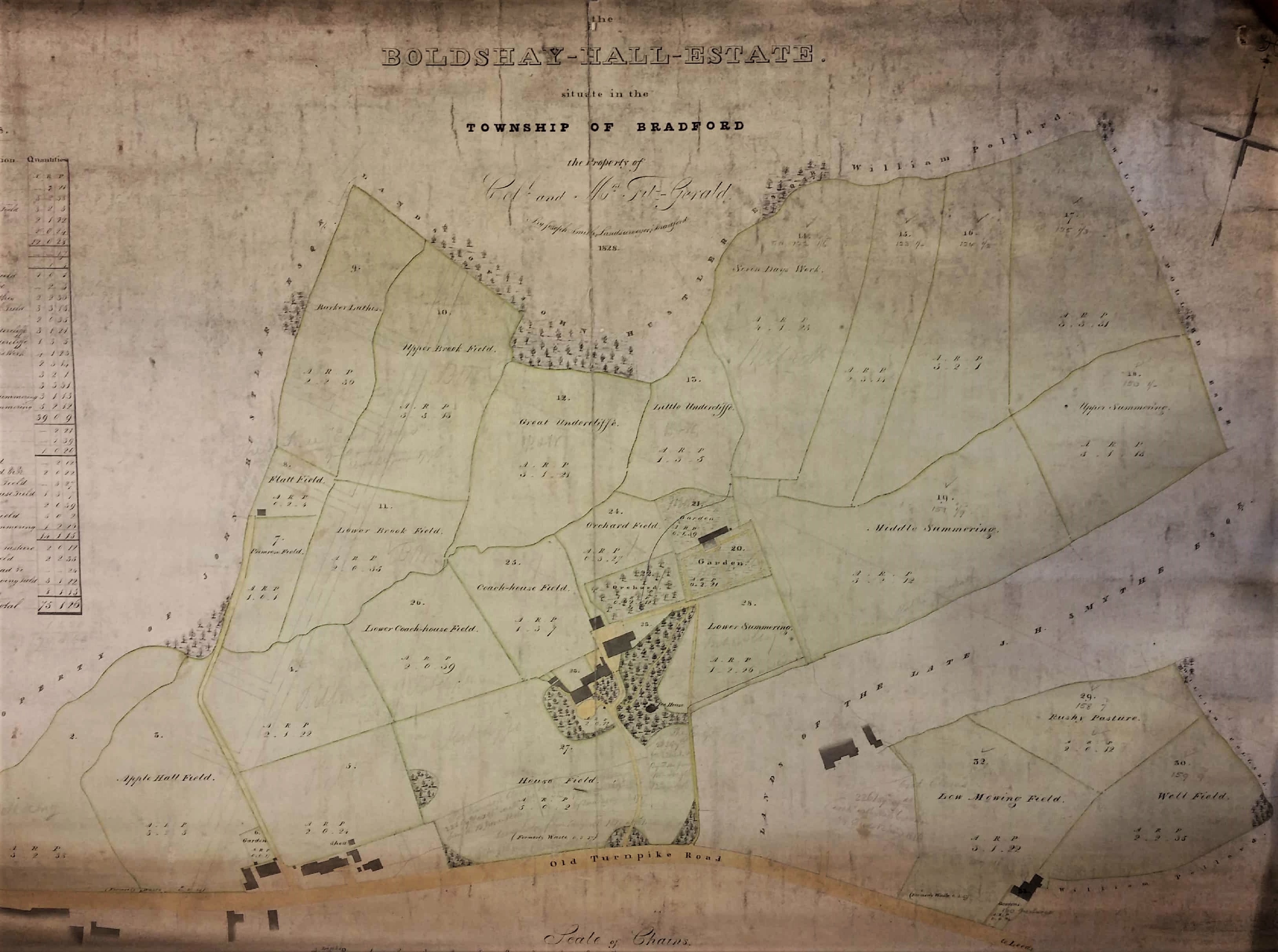
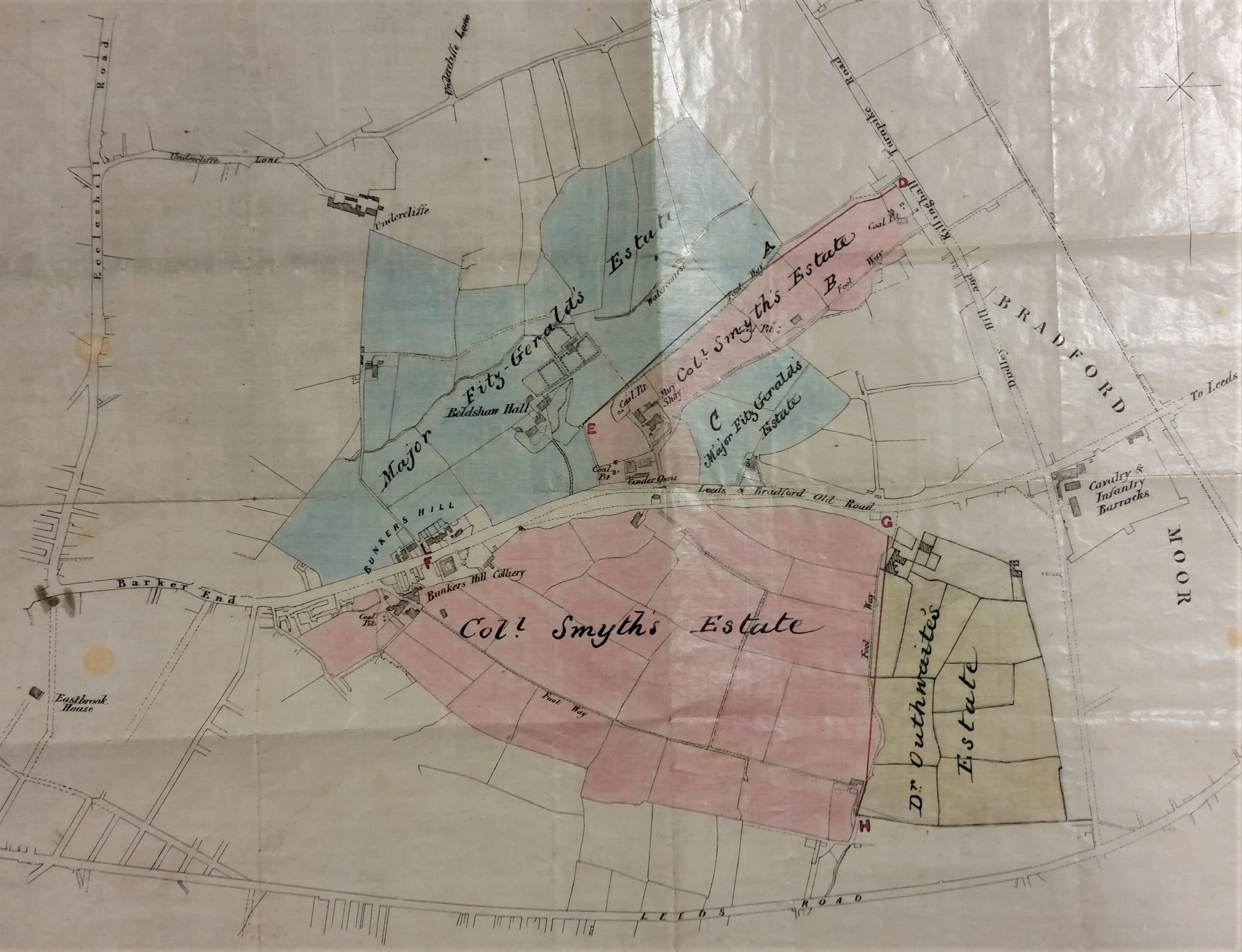
It is always an exciting moment when an important two hundred year old map, which does not appear to represent a copy of one already in the publicly accessible collection, turns up among the Local Studies Library’s reserve material.  The title of this map indicates that it produced for Colonel Thomas George Fitzgerald, who was a large landowner in Bradford until his death in the mid-nineteenth century. Local Studies has plans of his holdings elsewhere in the city, but no other copy of this plan of Boldshay Hall as far as I can see. The West Yorkshire Archives also has many documents relating to the estate.

Physically the map is a tinted, rolled, estate plan but it is dusty, in poor condition, and needed some repair before it could be handled safely. It was found in a group that seem to have come from Bradford Council. The next map was a post-war plan of Bradford’s twinned city Mönchengladbach, more recent by about 140 years! The unnamed building you can see a little south east of Boldshay is Miry Shay (or Miryshay) an older seventeenth century house. This has long been demolished but in the early nineteenth century had been the property of JH (John Henry) Smyth MP (1780-1822) whose family had owned it, and the Bradford Soke Mill, for generations. Smyth had died before the map was surveyed, and hence is referred to as ‘late’. The West Yorkshire Archives have a good deal of information about the Smyth family too. By the time of the 1852 Ordnance Survey map there was a large colliery just south of Miry Shay called Bunkers Hill. The land ownership in this area is made clearer by a second, later, LSL map which also illustrates that the name Bunkers Hill was in fact applied to a series of collieries along Barkerend Road.  The ‘Col. Smyth’ in this map is John George Smyth (1815-1869) MP for York and Colonel of the 2nd West Yorkshire Militia who lived at Heath Hall, Wakefield. His land holdings north of Barkerend Road are now a substantial part of Bradford Moor Golf Club.


Fig 031 B

The original Boldshay Hall Estate plan is dated 1828 and was drawn by Joseph Smith, of whom I will say more later. Boldshay Hall itself was built circa 1740 and at this early period was associated with the name of Samuel Hemingway and his son Henry Hemingway, who were both lawyers. The estate itself is presumed to be far older. Remarkably the hall still exists on Byron Street, surrounded by Victorian housing, and is Grade II listed. The gardens, fields, and coal mines which once enclosed it have long ago vanished completely.

As you would expect some previous owners of this historic building are described by William Scruton in Pen & Pencil Buildings of Old Bradford, and of course by William Cudworth. The estate passed to the Lister family of Horton Hall since Samuel Lister’s sister, Elizabeth Lister, had married Henry Hemingway. Their daughter, and Samuel Lister’s niece, Mary Hemingway married a Dr James Crowther MD of Leeds. After the death of Samuel Lister, and his second wife, Dr and Mrs Crowther inherited all the Lister estates and in due course their own daughter Elizabeth Crowther (1788-1838) became the Mrs Fitzgerald of the map’s title. Colonel Fitzgerald is Thomas George Fitzgerald, of Turlough, Ireland (1778-1850) who in 1819 had taken Elizabeth Crowther as his second wife at St George’s Hanover Square. Fitzgerald’s first wife also had a strong Bradford connection. Ten years earlier, in 1809 at St Peter’s, he had married Delia (1780-1817), daughter of Joshua Field, of Heaton Hall, and sister of John Wilmer Field. Two daughters died young but they had one son who took over their Irish estates. I should really like to know how Colonel Fitzgerald kept meeting Bradford heiresses and winning their hearts.

Fig 031 D

The hall itself is the large building in the centre of the group. I assume the rest are stables, farm buildings and coach houses; note the presence of an ice house. The agent for the estate, and other Fitzgerald properties, was Joseph Smith. Joseph Smith must have surveyed this map. He was succeeded by his son George Belk Smith who had designed the Bradford – Eccleshill turnpike in 1826. There are pencil annotations which are hard to read but seem, at least in part, to be records of the years in which certain parcels of land were acquired for the estate. I would like to know how long the Fitzgeralds lived at Boldshay Hall. After the death of Colonel Fitzgerald the estate passed to his son Major Henry Thomas George Fitzgerald (1820-1890) who had been born and baptised in Bradford but probably didn’t live here; his address is usually given at Maperton House, Somerset, which the Fitzgeralds also owned. Baines directory of 1822 confirms that Colonel Fitzgerald was in residence at that date but by the time Fitzgerald died in 1850 the Leeds Mercury recorded that he was ‘formerly of Boldshay Hall’. The 1828 map itself includes a list of tenants with their holdings, but nobody is leasing the hall where presumably, six years after the directory was published, the family still lived. It would appear likely that Colonel and Mrs Fitzgerald moved to Maperton House in the late 1820s. Could the resultant need for records of their local land holdings have been the reason that the map was originally created?

Interestingly around this time Boldshay Gardens became a place of public resort. The fact that they were no longer open for this purpose was formally announced in the Leeds Mercury in 1839. As I have mentioned before I am not a family historian and I am slightly puzzled by exactly who lived at Boldshay Hall after the Fitzgeralds. One of the map’s listed tenants is James Cousen. A man of this name is a partner in Rawson, Cousen & Co who were coal masters. This company owned the various Bunkers Hill collieries by the 1830s. His son, another James, (of Cousen, Thackrey & Co, stone-merchants of the canal basin) was given the address of ‘Boldshay’ in the press announcement issued when he died in 1830.  Possibly Boldshay Hall was subdivided since a local merchant named John Mann (1808-1845) was also giving Boldshay as his address by 1834. According to the Bradford Observer the same man won a prize for his lettuce at the Bradford Grand Floral & Horticultural Society in 1841. John Mann died in 1845 at the early age of 37. Probably James Cousen and John Mann were related. One family historian gives James Cousen’s second wife the name of Elizabeth Mann.  James Cousen senior still lived at the hall when he died at the age of 83 in 1844. I have also seen James Cousen’s name linked with Miry Shay although the only contemporary resident of this house I am certain of from press announcements is a Joseph Dalby, farmer, who died there in 1834.

The 1841 census makes the situation slightly clearer. At Boldshay Hall live John Mann (30) and wife Anne (who was to survive him by fifty years), two children and four servants. Andrew Newell, a gardener, lives at Boldshay Gardens. Miry Shay is more complicated. James Cousen, coal merchant, and his wife Elizabeth are certainly resident, but so also are a collection of coal miners, agricultural labourers, worsted weavers. and assorted descendants of the Dalbys. Understandably I have a personal weakness for Barkerend so exploring this map has been a real pleasure even if I have not found all the answers.

Derek Barker, Local Studies Library Volunteer

Local Studies Facebook Page

access app application apps

Photo by Pixabay on Pexels.com

The Local Studies Service now have our own Facebook page. So if you are on Facebook and are interested in local history, news and events, why not give us a like and follow the page.

https://www.facebook.com/BradfordLocalStudies/