Map of the Week: Askwith & Rev. Godfrey Wright

If, like me, you spend time studying nineteenth century maps of the Bradford district you are certain to have come across the name of Godfrey Wright as a landowner. Rev. Godfrey Charles Wright (1780-1862) possessed property in what would later become the the city centre but also at Horton, Manningham, Baildon, Eldwick and elsewhere. As a representative of all these maps I have selected, from the Local Studies Library reserve collection, this beautiful plan of Askwith which is a village between Ilkley and Otley north of the Wharfe valley. The plan employs different colours to designate the fields of several tenants but the landowner is clearly Wright.
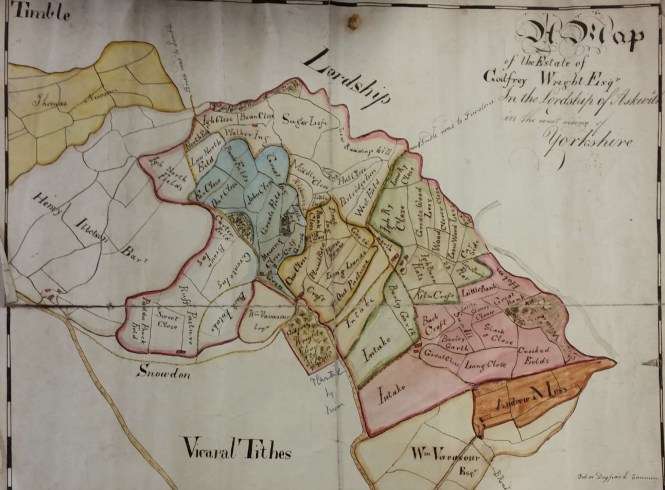
map-of-the-week-018

Stylistically this looks like a late eighteenth or early nineteenth century plan. Wright’s title is not used which also suggests an early date, before his ordination. He was awarded a Cambridge University MA in 1807 and presumably became a clerk in holy orders a few years later, although I don’t have an exact year for this. Wright does not seem to have lived in Bradford for any prolonged period, if at all. Certainly by 1822 was resident at Bilham House, Hooton Pagnell, near Doncaster, where he remained for the next 40 years. In census reports he described himself as a ‘clergyman without cure of souls’, and had an indoor and outdoor staff of a dozen or more. According to newspaper reports he subscribed to Leeds Infirmary and Bradford Infirmary, and was a member of the Camden Society with, presumably, an interest in early British history. He was described after his death as a staunch Conservative and he left to his heirs a substantial fortune. It is very natural to wonder how a clergyman acquired all this property.

Victorian Bradford historian William Cudworth believed that Godfrey Wright’s wealth resulted from a relationship with three local families: the Swaines, the Fields, and the Booths. That there was such a connection is certain since Wright used all three surnames as his own sons’ middle names. A collection of Wright papers in the West Yorkshire Archives (Bradford) contains much earlier material relating to the Swaines and Booths. Cudworth also suggested that Wright benefited indirectly from the estate of Abraham Sharp of Horton Hall, the famous mathematician. This is true but the amount involved may not have been significant. There is little doubt that, however he acquired them, the fields and cottages in his possession became substantially more valuable as space in an expanding Bradford became increasingly necessary for new roads, mills, dwellings and public buildings. Wright owned the land on which Little Germany and St George’s Hall were eventually built, for example. Consequently Wright reaped a substantial fortune from the prosperity of the Bradford borough, a fact that evidently had occurred to his contemporaries if newspaper reports are to be believed. The development of Little Germany is a particularly interesting story and one to which I must return in the future. Godfrey Wright left £80,000 at his death in 1862 which equates, according to the National Archives currency converter, to £3,452,800 at 2005 values.

You will, I am sure, have heard of Abraham Sharp who was a distinguished mathematician and scientist. He lived and worked at Horton Hall in Little Horton Green but sadly the hall was demolished many years ago. Cudworth mentions a certain ‘Dr Swaine of Hall Ings’ who was an eminent apothecary and a great friend of Abraham Sharp. There is also a Swain (sic) tablet in Bradford cathedral. It commemorates William Swain of Bradford and his family:


William Swain                                                     d.1737 aged 71

Son,  William                                              d.1715 aged 20

Son,  Abraham                                            d.1732 aged 34

Abraham Swain (brother of elder William)               d.1731 aged 58

Son, Abraham                                            d.1733 aged 28

I think it is reasonable to assume that only wealthy families of some consequence had commemorative tablets inside the old Parish Church. The monument was erected by Mary and Elizabeth Swain, co-heiresses of the family. Mary seemingly stayed single but Elizabeth was to make a significant marriage.

George II became king in 1727. The following year, according to a West Yorkshire Archives indenture, two spinsters Elizabeth & Beatrix Field (daughters of William Field ‘late of Bradford’) are involved financially with an Abraham Swaine. He is possibly the elder man of this name on the Parish Church tablet. The document mentions a great many fields, barns and dwellings. Some familiar place names are: Goodman’s End, Silsbridge and Penny Oak, all in Bradford. One dwelling is occupied by ‘the widow Beatrix Field’ who is likely, I suppose, to be the girls’ mother. Clearly the Field family must also be linked to Godfrey Wright if their family papers ended up in his archive.

Remember the two Swaine girls, Mary & Elizabeth? Mary Swaine may be the ‘Aunt Swaine’ who lived in Hall Ings, dying in 1759. Her sister Elizabeth Swaine definitely married Rev Charles Booth snr. They had a number of children including Charles Booth jnr. who was born in 1734. Fortunately the will of Rev Charles Booth snr. survives in the West Yorkshire Archives. Amid the legal language there are three important facts: Rev Charles Booth was a wealthy man himself with much cash and property. Sarah & Beatrix Booth were his only surviving daughters who were left £500-£1000 each, which would be hundreds of thousands of pounds in a modern money equivalent. Finally, Charles Booth jnr. was his only surviving son being made executor, land inheritor and residuary legatee. The lands involved were in the parishes of Halifax and Bradford although the only names I am certain about are Ovenden and, I am glad to say, Askwith. I think then that we can be certain that the plan I have selected displays property that Godfrey Wright eventually inherited from Charles Booth jnr.

Charles Booth jnr. was a wealthy young barrister. He changed his name to Charles Swaine Booth after inheriting yet more property from his aunt who, as I say, was presumably Mary Swaine of Hall Ings. By this means I believe he obtained the whole of the Booth and Swaine inheritances but he had one more piece of financial luck, and one more name change, to come. A lady called Hannah Gilpin had already changed her own name to Hannah Gilpin Sharp. Essentially Hannah had inherited Abraham Sharp’s Horton estate via his niece Faith Sawrey who died in 1767 without any children. As you may have guessed Charles Swaine Booth married Hannah. After 1769 the couple lived together at Horton Hall under their final married names of: Charles SB Sharp (1734-1805) & Hannah Gilpin Sharp (1743-1823). The custom at the time would have been for Charles to have acquired control of his new wife’s considerable wealth. A married woman could not own property of her own but in rich families her future could be protected by a marriage settlement, which was in some ways like a modern pre-nuptial agreement. Under such a settlement some property was placed in the hands of trustees who would manage it to provide an income for a wife or, in due course, a widow. Thus the interests of a wife would be protected if the husband was a poor businessman, or developed expensive hobbies like drinking or gambling. She was, of course, still dependant on the business acumen of the trustees but rental properties or consolidated stocks will have represented secure investments.

A marriage settlement between Charles and Hannah survives and Hannah seems to have been well provided for after her husband’s death in 1805. When he died Charles had no living brothers or children and was clearly in need of an heir. He seems to have left his own considerable property to his sisters Sarah & Beatrix, but when in turn they died without children control of the inheritance was passed to Godfrey Wright although on the face of it he was a rather distant family member. The closest common relative would appear to be the Rev Marmaduke Drake, a vicar in Derbyshire, who was Godfrey Wright’s great grandfather and who married a Field. If any local historian has studied his extended family I would be pleased to learn more.

Godfrey Wright was born in 1780 at Kimberworth, Rotherham and educated at Hipperholme Grammar School (like Sir Robert Peel) and Trinity College, Cambridge after 1799 (MA 1807). He married in 1812, at Huddersfield, Mary Stables (1790-1821) but his wife died at Bath while still a young woman. Wright was already described as being ‘of Bilham House’. He frequently visited Bath, York & London for the season according to contemporary newspapers. He was also Lord of the Manor of Marton, Sinnington, near Pickering, NRY. In the 1800s his land agents were reported as being Joseph Smith and then Thomas Hirst of Hall Ings, Bradford. Wright was involved in a legal action, Rawson v. Wright, brought by the Lord of the Manor against him in 1825 for the erection of the Waterloo market in Hall Ings (Charles St). Rawson won although Cudworth records that Godfrey Wright attracted considerable public sympathy since more market accommodation was certainly needed in Bradford. Wright was also involved in some controversy over paving Hall Ings in 1836.  In 1850 he owned the land on which a public hall (St George’s) was built and got £15,000 for it (Bradford Observer October 17 1850). The Bradford Observer February 26 1857 stated that he owned The Beehive Inn and other ‘low’ dwellings in the Silsbridge Road area. This Beehive estate was eventually purchased by the Council from his trustees for £5,775, in 1864.

Cudworth states that Hannah Gilpin Sharp (aka Madam Sharp) long outlived her husband finally dying in 1823 at the age of eighty. Godfrey Wright didn’t inherit the Sharp property although he was executor of, and beneficiary from, Hannah Gilpin Sharp’s will. The Hall and the associated land went to Mrs Ann Giles, who also figures regularly as a landowner in maps of Bradford and Horton. I assume that this property was managed for her by trustees. My conclusion is that in the nineteenth century people could do well financially by surviving and being prepared to change their surnames. If you want to learn the fascinating history of Horton Hall, both before and after Charles Swaine Booth and Hannah Gilpin Sharp, you must read the excellent Sharp to Blunt by local historian Astrid Hansen (Bradford Libraries, 2000). Copies are available in the library.

Derek Barker, Local Studies Library Volunteer



Cross Roads War Memorial is Recreated

In 2011 military historians from the Men of Worth Project carried out a survey of all war memorials in the Keighley area removed from churches and other buildings because of their closure.

One of these was from Cross Roads Primitive Methodist Sunday School.  A photograph of the original memorial was included in an album in the Keighley Local Studies Library but the whereabouts of the memorial was a mystery.

In 2015 the photographs were discovered listed in archive BK115, Cross Roads Primitive Methodist Chapel records. At some time in its history the photographs had been taken out of the frame to preserve them from water damage and stored in the Keighley archives for conservation purposes.

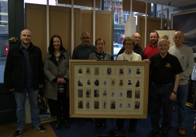
Once these images came to light, historians from the Men of Worth project set about recreating the memorial with the original photograph as a guide. Using copies of the original photographs, the images were digitally enhanced and a replica of the memorial was made.

Business people in the town assisting in the making of it including Robert Riley of R & J  Riley Joiners who built the frame while M J Framing on High Street cut and made the mount for the sections. Sheila Butler carried out calligraphy for the men’s names.

Congratulations to all involved, especially Ian Walkden and Andy Wade from Keighley’s Men of Worth project for all their painstaking work in bringing this piece of history back to life, commemorating the bravery of local men from the First World War.

The replica memorial features names and photographs of many men. However sadly, some of the photographs are not present. These are:

Pte. Alfred Firth
2nd South Staffords

Pte. Fred A. Pickles
1/6th Duke of Wellingtons

Pte. Arthur Dinsdale
6th West Riding Regiment

Pte. John R. Bowker
Somerset Light Infantry

Pte. Asa Aspinall
Royal Fusiliers

Perhaps photographs of these men may exist in private collections and come to light in the future.


group

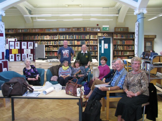
The completed memorial is presented to Cllr Tito Arana of Haworth Cross Roads and Stanbury Council at a presentation event attended by military historians from Men of Worth project, local tradespeople and library staff.

iwcross

Ian Walkden (back right) from Men of Worth project speaking to a group in Keighley Local Studies Library


Book Reviews – The Low Moor Explosion

The Low Moor Explosion, August 21st 1916. A Mystery Explained? By Ronald Blackwell. Augmented Reprint. Published by the Low Moor Local History Group, 2016. 144 pages. A4 format. Illustrated.

Yellow Poppies. The Dead and those who received honours as a result of the 1916 Low Moor Munitions Explosion. By Barbara Reardon and Mary Twentyman. Low Moor Local History Group, 2016. 110 pages. A4 format. Illustrated.

On August 21st 1916, a series of explosions took place at the Low Moor Munitions Works which resulted in the deaths of forty people, six of whom were corporation firemen. It was wartime, and picric acid was produced at the works. The acid was reduced to a powder and bagged ready for transportation to shell-filling works elsewhere. The cause of the initial fire appeared to be either that a drum containing the powdered acid was not adequately insulated on its exterior surface and inappropriate handling of the drum by a worker caused picrate deposits to combine with the metal leading to combustion; or, that the drums, which were being transferred to a packing shed, were not covered on top as safety requirements stated and a spark or descending hot clinker from an adjoining part of the works could have come in contact with the open drum and caused ignition. The fire thus started in the drum entered the building where the stored picric then caught fire, leading to explosions all over the site. Hot flying debris landed on adjacent corporation gas holders, leading to their wholesale destruction and that of adjoining buildings. The accident investigators commented that the works were holding far more picric acid than its licence permitted. The company, though, was under pressure to produce as much as possible for the war effort.

In 1987, Ronald Blackwell wrote a detailed and comprehensive account of the accident, but his book has long been out-of-print and hard to obtain. Since its publication more details have been uncovered with much research carried out on the people who were killed or who were involved. As a consequence the Low Moor Local History Group decided to commemorate the centenary of the explosion by re-printing the book and to add these further details. The book has now been reprinted in its entirety with the addition of Blackwell’s article in the Bradford Antiquary of 1987, which gave a simplified account of the disaster and a revised list of the dead. Also added is are two new names, other new information, and the transcription of the citation recommending a bravery award that had been submitted later. Ronald Blackwell supported this augmented re-publication.

Since the 1980s new sources have become available, most notably census data and the ability to search some newspapers digitally, so it was decided to research details of the people who were killed in the explosion and those who received national awards for their bravery. Their stories are told in a separate publication, Yellow Poppies. The title relates to the fact that the people working in the area were often referred to as ‘canaries’ due to the fact that their skin often acquired a yellow tinge from the sulphur content of the acid, and also, of course, the poppy being a symbol for the war – the reason why explosives were being manufactured at Low Moor in the first place. Typically, each of the forty victims has a double-page spread giving details of their part in the disaster, their background, and information about their surviving families, with photographs. Similar treatment is given to a number of the firemen, managers and telephonists who were involved in the disaster but survived.  Finally there is information about the national and local awards for bravery that were awarded. The book is profusely illustrated.

Both authors are experienced in family history research and this marvellous publication demonstrates how much information can be discovered using modern research methods, despite the difficulties caused by wartime news restrictions. More importantly, it brings back life these brave and innocent people, of which Low Moor can be proud.

Bob Duckett


The publications can be borrowed from the library service or purchased from the publishers c/o 13 St Abbs Fold, Odsal, Bradford, BD6 1EL. Email: info@lmlhg.org.uk.


Map of the Week: Blake Hill Cottage, Idle

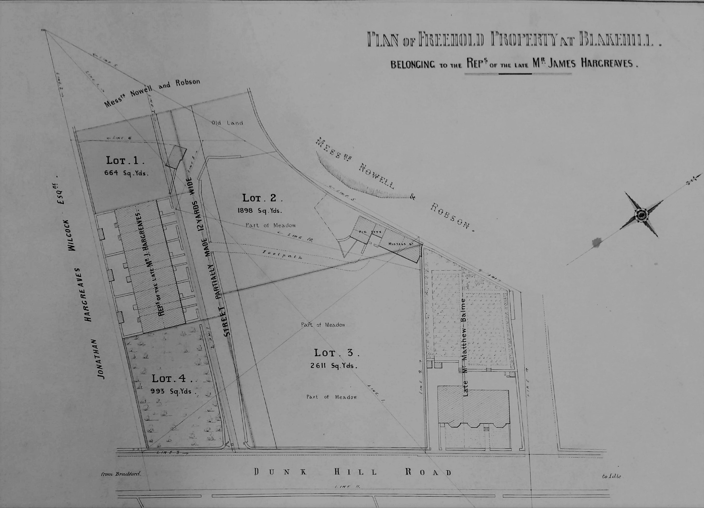
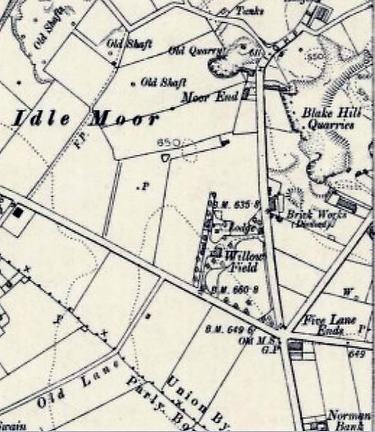
map-of-the-week-017aAt first sight this would appear to be a rather pedestrian sale plan but in fact it contains several points of interest. It clearly represents a freehold property at Blakehill which presumably was for sale. So, where is Blakehill located on a road that connects Bradford and Idle? On Idle Moor there was a large stone extraction site called Blake Hill Quarry which at one time was associated with a brick works. It was a little further north than Five Lane Ends and lay between modern Highfield Road and Bradford Road. In fact the whole locality was extensively quarried for Elland Flags, but in many cases the individual quarry names seem to be unrecorded or inaccessible. As you can see the surveyed land is situated on ‘Dunk Hill Road’. I cannot identify this thoroughfare by name but Dunk Hill as a place is included on Victorian OS maps of the area. Where exactly could this plot be? I am confident we are looking at Bradford Road, but the junction between two adjacent OS maps rather inconveniently passes between the two properties on the plan!

The second map is from the 1906 OS and shows a more general view. The short terrace is positioned next to the word ‘works’. It is possible that the cottage aligned on the road still exists opposite Enterprise Way, if you allow for an extension having been built. The short terrace must then have vanished under a YEB sub-station. If anyone with a greater knowledge of Idle could correct me I should be most grateful.

map-of-the-week-017b

In trying to explain the plan further it seemed most sensible to start with the small house and garden belonging to ‘the late Mr Matthew Balme’, since his was a name I recognised. Matthew Balme (1813-1884) was the registrar of births & deaths for Bolton, Idle, and Eccleshill. Victorian historian William Cudworth mentions him as a ‘gentleman of some note’ devoted to ameliorating the lot of factory workers. As a young man he was an associate of John Wood and Richard Oastler, in such enterprises as the Ten Hour Bill (1847) which placed some restraint on the activities of dark satanic mills. For some years Balme was a master at John Wood’s factory school and he certainly attended Oastler’s funeral in 1861. In 1865 he had been elected clerk of the Bolton Local Board. Balme died in 1884 so the plan must evidently be a little later than this date. Using other resources available free in the Bradford LSL I looked for Balme’s entry in the 1881 census which proved helpful.

The census entries were located between Bradford Road and Albert Street, Idle. In the returns a ‘Blakehill Cottage’ is described as ‘recently built’. There Matthew Balme (67) lived with his daughter Mary (37) and Elizabeth Priestley (61), his widowed sister. Cudworth mentions that Balme lived first at Delph Hill Farm and then at Ivy Cottage. It is possible that Ivy Cottage was also known as Blakehill Cottage, but more probably Balme made a further and final move to a new house during the three years of life left to him. Matthew Balme died at Idle and is buried in St Wilfrid’s Church, Calverley where his tombstone is still easily visible. In monetary terms he was not a wealthy man, leaving less than £200. The fact that his friends inscribed on his monument ‘Defend the poor and fatherless: do justice to the afflicted and needy‘ (Psalms 82:3) reveals how rich he was in other ways. His daughter Mary is buried with her father and remarkably we know a little more about her interests. Bradford Museums & Galleries curates an adjustable reading desk once the property of the Bradford Scientific Association. Mary Balme joined the association in 1906 and the desk was made with a legacy she left them when she died in 1931. You can read Heather Millard’s most interesting account of this object at:

Bradford Museums

The land outside most of the perimeter of the plan belongs to Messrs Nowell & Robson and in one place there appears to be a quarry edge. I attempted to locate this partnership in various trade directories. Nowell & Robson were clearly quarry owners and stone merchants; they also operated a coal mine in Raistrick. They had a London office at Westbourne Park Road, Bayswater from which they seemed to be providing paving slabs for London and working on the metropolitan sewer system. Possibly Robson provided the London contracting arm of the business. Certainly in the 1881 census, next to Blakehill Cottage, was Blakehill House, where Joseph Nowell (57), a stone merchant born in Dewsbury, lived with his wife and children. Assuming that there was only one house of this name it must have had a rather lurid reputation at the time of the census. At Blakehill House, Eccleshill in 1874 Joshua Armitage, ‘a lunatic’, was charged with the murder of John Howard, his attendant, who was seemingly strangled with a bath towel.

Because of his unique name I easily identified Jonathan Hargreaves Wilcock (1818-1890) who owns the remainder of the land outside the perimeter. He was a farmer of Owlet Hall, Idle (presumably the one now in Festival Avenue, Bolton). He was living there in 1881, being married to Hannah and having children Amelia & Harper. When he died in 1890 probate was granted for a substantial sum of more than £5000. As far as the plan landowners were concerned I was then left with James Hargreaves. There was of course a very famous man of this name who invented the Spinning Jenny. Well, it cannot be him, nor can it be the man Cudworth describes as James Hargreaves of Delph Hill: remember Delph Hill? This second man was a farm labourer who learned to weave after working hours. Having saved some money he leased Delph Hill Farm. He carried his first cloth pieces to Bradford market to sell. His sons William and Joseph later took Frizinghall Mill & Red Beck Mill for worsted weaving. But this James Hargreaves had died in 1816 so our man can neither be him, nor any son of that name.

The truth is that James Hargreaves was a common name. Since he is described as ‘late’ the man from the plan is likely to have died in the mid-1880s. I imagined him as a wealthy developer, rather than an occupant of one of the houses. Assuming that, as a man of property, he would have left a will I investigated probate records. The most plausible man was James Hargreaves (1834-83), ‘late of Eccleshill’, who died in Staverton, Wiltshire in 1883. His wife Elizabeth sought probate on a will leaving excess of £30,000; a huge sum for those days. The money was unsurprisingly earned as a cloth manufacturer. Another hint is that in 1883 one Henry Hargreaves, son of Elizabeth and James (manufacturer) was baptised at St Luke’s, Eccleshill. This was an adult baptism since Henry had been born in 1861. Possibly Henry had originally been baptised in another denomination and now wished to become an Anglican. James, with his wife Elizabeth Hargreaves and Jonas Hargreaves his brother, are in the 1871 census living at Lands Lane, Eccleshill. I can confirm this from the 1879-80 PO Directory. Why their son Henry is not with them in 1871, whether Jonathan Hargreaves Wilcock was related them, and how James came to die in Wiltshire, are questions I shall leave to better family historians than myself to resolve. At least I got you started, or at least this plan did.

Derek Barker Library Volunteer

Map of the week: The Bull’s Head Inn, Westgate

It is relatively unusual to be able to match plans with a surviving drawing. The first image is a map in the Local Studies Library reserve collection which plots a strip of land extending from Westgate, near the city centre, down to the old goit which once supplied the Soke Mill (or Queen’s Mill) with water. Very helpfully it unmistakably identifies a building called the Bull’s Head Inn.

map-of-the-week-016a

In the second map from the same collection I have hatched the buildings concerned to place them in a more general view of this part of Bradford in the years 1870-80. The creation of new thoroughfares, and extensive building redevelopment, results in a very different street pattern today.

map-of-the-week-016b

William Scruton, in his Pen & Pencil Pictures of Old Bradford included an illustration of the Bull’s Head itself. In this third image you may just be able to make out the design on the tavern sign. Neither drawing nor plans can be later than 1886 by which time the inn was no longer in existence, but it is likely that they are approximately contemporary. I know that there were other Bull’s Heads in Great Horton, Baildon, Thornton and Halifax and for this reason it is important compare images to check that everything matches up. The prominent features in the drawing are the projecting windows on either side of the door and the arched passageway which gave access to the rear of the property which was known as Bull’s Head Yard. These features are replicated in the plan, so there really can be little doubt that we are looking at a single building.

map-of-the-week-016c

Scruton says that at one time in front of this inn was a ring for bull-baiting, which presumably provided its name. Close-by was the town pillory in which offenders were manacled while being subject to the abuse of passers-by who could hurl eggs or fruit at them. I have seen a watercolour print which places the pillory on a wooden stage just about where the figure is sitting. This form of punishment was outlawed in 1830 and bull-baiting was forbidden after 1835. The Victorian historian William Cudworth, in his own account of the inn, doesn’t mention ball-baiting but says that in front of it was a market with rows of butchers’ stalls; another possible source for the name then. Whatever the truth there is not much doubt that Scruton was thinking of the situation in the late eighteenth century. At that time the Bull’s Head was used by merchants, manufacturers and woolstaplers. The first Bradford Club was founded there, according to Cudworth, in 1760. By the early nineteenth century a Mrs Duckitt was the host. She was apparently famous for her rum punch, which isn’t a beverage that I have ever tried. An Act of Parliament in 1805 appointed commissioners for levying rates and improving Bradford roads and lighting. These commissioners, a sort of primitive town council, met at the Bull’s Head. In some ways it was our first Town Hall. Apparently 60 years before Scruton’s book was published, which would therefore be in the 1830s, the inn was also a rendezvous for town and country musicians.

Inns are usually easy to trace in other Local Studies  resources such as trade directories and newspapers. I only wish I had more time for a more detailed study. The 1818 and 1822 commercial directories place Jeremiah Illingworth in charge at the Bull’s Head. It seems then to have then doubled as an Excise Office. In 1829 Hannah Illingworth, perhaps Jeremiah’s widow, ran the establishment which was clearly a large one since on one occasion in 1834 no less that fifty friends of Airedale College dined there together. On the other hand there are reports of fights in the street outside, and in 1837 a licenced hawker, Henry Stephens by name, was fined the huge sum of £10 for trying to sell a watch and razors in the bar parlour. Later that same year Joseph Sugden, who was now in charge, was reported as providing another excellent dinner, this time for 56 members of the Ancient Order of Oddfellows. Acceptable early Victorian dinners always seem to be described as ‘good’ or ‘excellent’ for some reason.

At the time of the 1850 Ibbetson directory Joseph Sugden was still the host. Manufacturers from outside Bradford would attend an inn on a regular basis so that they could be easily found if you wished to transact business. Among textile men at the Bull’s Head you could find John Anderton, manufacturer of Harden, and Samuel Dawson of Wakefield. Other visitors were Messrs Pilling, corn millers, and John Hirst, land agent, who attended on Thursdays. The LSL offers free access to the family history site Ancestry.UK and using this site it is not hard to find Joseph Sugden (47) in the 1851 Bradford census. He lives with his wife Sarah and two children, together with a charwoman, an ostler, and three servants. I assume he would also have non-resident staff. His immediate neighbours are: booksellers, druggists, drapers and plumbers.

Some of Sugden’s patrons must surely have come from the surrounding streets where wool-combing was a very common occupation. This trade was on the verge of being destroyed by the mechanical wool-combs developed in Bradford by Samuel Cunliffe Lister and Isaac Holden. The habits of those patrons is hinted at by the fact that in 1869 Thomas Burrows was arrested in Bull’s Head Yard in possession of two spittoons, thought to be the property of Thomas Waterhouse, then of the Inn. It remained a significant local building and in 1874 the Bradford Musical Union dined there, inviting the Mayor and local jeweller Manoah Rhodes as guests. I have followed entries for the inn in the Bradford Observer up to 1875, when it was being used for election candidates’ addresses.

The Bull’s Head is on the same alignment as Westgate, as indeed are all neighbouring premises. The rear yards however are aligned as an angle to the thoroughfare. This is also true in the much older 1800 map of Bradford. The yards and properties are running south-west following even earlier field boundaries. You may be able to see that the first map has been annotated in pencil. The annotations are not generally legible but they would appear to indicate the types of premises found in Bull’s Head Yard. The only proprietor I can be certain of is a Mrs Smiddles who ran a tripe shop, but there are also sheds and stables. I haven’t been very successful in tracking down any other businesses based there. In 1850 John Hebden, fishmonger, gave this address but the 1851 census shows he was actually living nearby in Reform Street which is clearly shown in the second map. Perhaps he had a shop in the yard combined with a house entered from the next street. In 1857 Tennand, Hall & Hill of Manchester, who were tanners and curriers, advertised that they visited Bull’s Head Yard weekly.

The Bull’s Head at 11 Westgate was still run by Joseph Sugden according to a 1866 trade directory. It is listed under the name J Halliday in the directory of 1879-80. In the directory of 1883 the inn is missing. The Lord of the Manor had the medieval right to a corn-milling monopoly at the Soke Mill, which had stood above Aldermanbury for centuries. Bradford Corporation bought out this right in 1870. In the mid 1870s clearance of much of the property in this area began, and modern Godwin Street was created. At the top of the first plan the elevation of various points is related to Sun Bridge Road. This would have been relevant during such a period of development. Does any of this area survive? I would imagine that everything was destroyed when Godwin Street was brought up to intersect with Westgate. Walking along Godwin Street and Sackville Street today, both in reality and using Google Earth, I cannot persuade myself that any of the mapped buildings are still present. But I should so very much like to be proved wrong.


Derek Barker, Local Studies Library Volunteer