Map of the Week: Blake Hill Cottage, Idle

map-of-the-week-017a
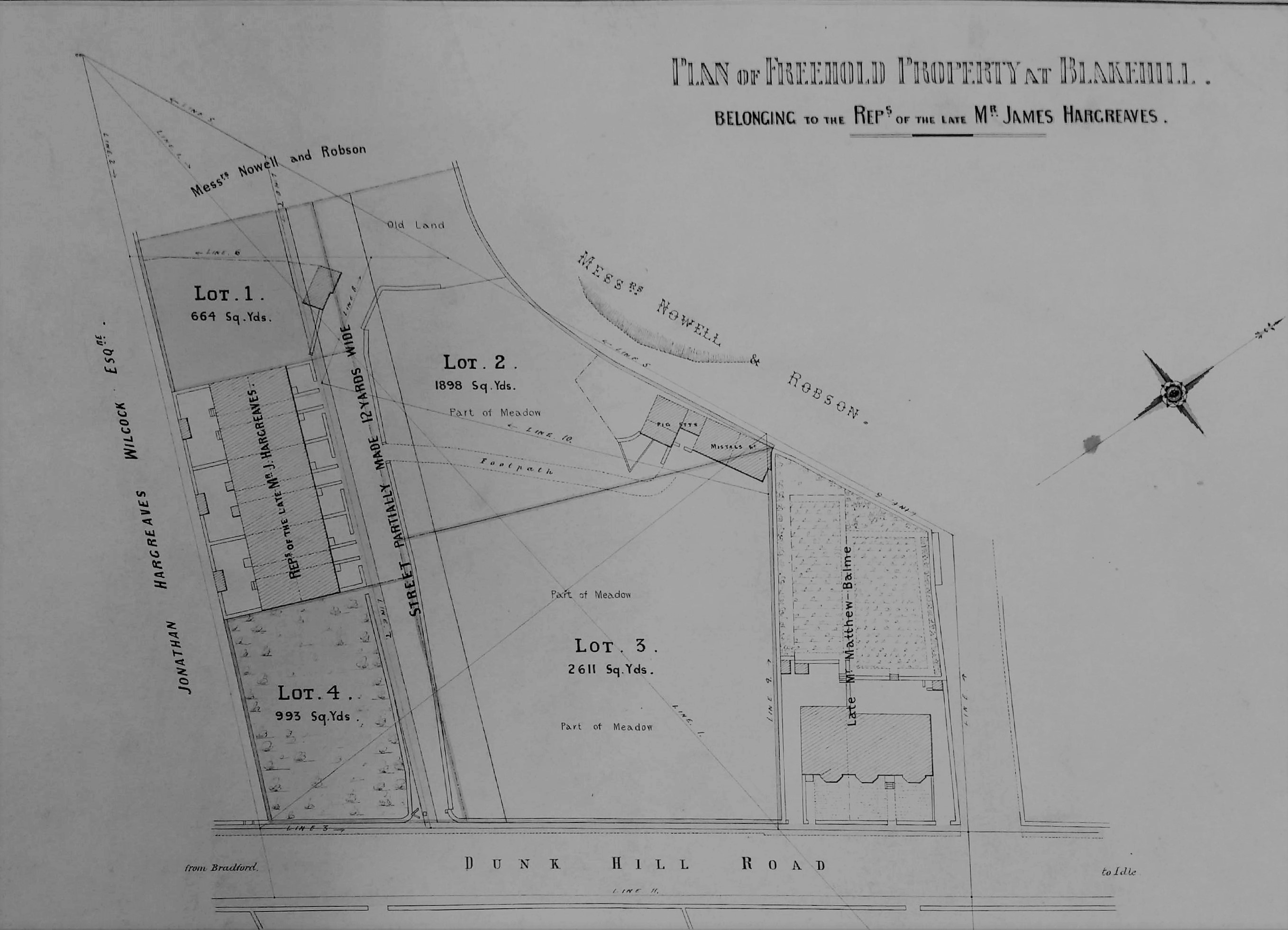
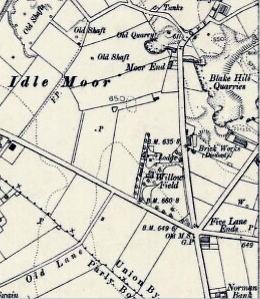
At first sight this would appear to be a rather pedestrian sale plan but in fact it contains several points of interest. It clearly represents a freehold property at Blakehill which presumably was for sale. So, where is Blakehill located on a road that connects Bradford and Idle? On Idle Moor there was a large stone extraction site called Blake Hill Quarry which at one time was associated with a brick works. It was a little further north than Five Lane Ends and lay between modern Highfield Road and Bradford Road. In fact the whole locality was extensively quarried for Elland Flags, but in many cases the individual quarry names seem to be unrecorded or inaccessible. As you can see the surveyed land is situated on ‘Dunk Hill Road’. I cannot identify this thoroughfare by name but Dunk Hill as a place is included on Victorian OS maps of the area. Where exactly could this plot be? I am confident we are looking at Bradford Road, but the junction between two adjacent OS maps rather inconveniently passes between the two properties on the plan!

The second map is from the 1906 OS and shows a more general view. The short terrace is positioned next to the word ‘works’. It is possible that the cottage aligned on the road still exists opposite Enterprise Way, if you allow for an extension having been built. The short terrace must then have vanished under a YEB sub-station. If anyone with a greater knowledge of Idle could correct me I should be most grateful.

map-of-the-week-017b

In trying to explain the plan further it seemed most sensible to start with the small house and garden belonging to ‘the late Mr Matthew Balme’, since his was a name I recognised. Matthew Balme (1813-1884) was the registrar of births & deaths for Bolton, Idle, and Eccleshill. Victorian historian William Cudworth mentions him as a ‘gentleman of some note’ devoted to ameliorating the lot of factory workers. As a young man he was an associate of John Wood and Richard Oastler, in such enterprises as the Ten Hour Bill (1847) which placed some restraint on the activities of dark satanic mills. For some years Balme was a master at John Wood’s factory school and he certainly attended Oastler’s funeral in 1861. In 1865 he had been elected clerk of the Bolton Local Board. Balme died in 1884 so the plan must evidently be a little later than this date. Using other resources available free in the Bradford LSL I looked for Balme’s entry in the 1881 census which proved helpful.

The census entries were located between Bradford Road and Albert Street, Idle. In the returns a ‘Blakehill Cottage’ is described as ‘recently built’. There Matthew Balme (67) lived with his daughter Mary (37) and Elizabeth Priestley (61), his widowed sister. Cudworth mentions that Balme lived first at Delph Hill Farm and then at Ivy Cottage. It is possible that Ivy Cottage was also known as Blakehill Cottage, but more probably Balme made a further and final move to a new house during the three years of life left to him. Matthew Balme died at Idle and is buried in St Wilfrid’s Church, Calverley where his tombstone is still easily visible. In monetary terms he was not a wealthy man, leaving less than £200. The fact that his friends inscribed on his monument ‘Defend the poor and fatherless: do justice to the afflicted and needy‘ (Psalms 82:3) reveals how rich he was in other ways. His daughter Mary is buried with her father and remarkably we know a little more about her interests. Bradford Museums & Galleries curates an adjustable reading desk once the property of the Bradford Scientific Association. Mary Balme joined the association in 1906 and the desk was made with a legacy she left them when she died in 1931. You can read Heather Millard’s most interesting account of this object at:

Bradford Museums

The land outside most of the perimeter of the plan belongs to Messrs Nowell & Robson and in one place there appears to be a quarry edge. I attempted to locate this partnership in various trade directories. Nowell & Robson were clearly quarry owners and stone merchants; they also operated a coal mine in Raistrick. They had a London office at Westbourne Park Road, Bayswater from which they seemed to be providing paving slabs for London and working on the metropolitan sewer system. Possibly Robson provided the London contracting arm of the business. Certainly in the 1881 census, next to Blakehill Cottage, was Blakehill House, where Joseph Nowell (57), a stone merchant born in Dewsbury, lived with his wife and children. Assuming that there was only one house of this name it must have had a rather lurid reputation at the time of the census. At Blakehill House, Eccleshill in 1874 Joshua Armitage, ‘a lunatic’, was charged with the murder of John Howard, his attendant, who was seemingly strangled with a bath towel.

Because of his unique name I easily identified Jonathan Hargreaves Wilcock (1818-1890) who owns the remainder of the land outside the perimeter. He was a farmer of Owlet Hall, Idle (presumably the one now in Festival Avenue, Bolton). He was living there in 1881, being married to Hannah and having children Amelia & Harper. When he died in 1890 probate was granted for a substantial sum of more than £5000. As far as the plan landowners were concerned I was then left with James Hargreaves. There was of course a very famous man of this name who invented the Spinning Jenny. Well, it cannot be him, nor can it be the man Cudworth describes as James Hargreaves of Delph Hill: remember Delph Hill? This second man was a farm labourer who learned to weave after working hours. Having saved some money he leased Delph Hill Farm. He carried his first cloth pieces to Bradford market to sell. His sons William and Joseph later took Frizinghall Mill & Red Beck Mill for worsted weaving. But this James Hargreaves had died in 1816 so our man can neither be him, nor any son of that name.

The truth is that James Hargreaves was a common name. Since he is described as ‘late’ the man from the plan is likely to have died in the mid-1880s. I imagined him as a wealthy developer, rather than an occupant of one of the houses. Assuming that, as a man of property, he would have left a will I investigated probate records. The most plausible man was James Hargreaves (1834-83), ‘late of Eccleshill’, who died in Staverton, Wiltshire in 1883. His wife Elizabeth sought probate on a will leaving excess of £30,000; a huge sum for those days. The money was unsurprisingly earned as a cloth manufacturer. Another hint is that in 1883 one Henry Hargreaves, son of Elizabeth and James (manufacturer) was baptised at St Luke’s, Eccleshill. This was an adult baptism since Henry had been born in 1861. Possibly Henry had originally been baptised in another denomination and now wished to become an Anglican. James, with his wife Elizabeth Hargreaves and Jonas Hargreaves his brother, are in the 1871 census living at Lands Lane, Eccleshill. I can confirm this from the 1879-80 PO Directory. Why their son Henry is not with them in 1871, whether Jonathan Hargreaves Wilcock was related them, and how James came to die in Wiltshire, are questions I shall leave to better family historians than myself to resolve. At least I got you started, or at least this plan did.

Derek Barker Library Volunteer

Map of the week: The Bull’s Head Inn, Westgate

It is relatively unusual to be able to match plans with a surviving drawing. The first image is a map in the Local Studies Library reserve collection which plots a strip of land extending from Westgate, near the city centre, down to the old goit which once supplied the Soke Mill (or Queen’s Mill) with water. Very helpfully it unmistakably identifies a building called the Bull’s Head Inn.

map-of-the-week-016a

In the second map from the same collection I have hatched the buildings concerned to place them in a more general view of this part of Bradford in the years 1870-80. The creation of new thoroughfares, and extensive building redevelopment, results in a very different street pattern today.

map-of-the-week-016b

William Scruton, in his Pen & Pencil Pictures of Old Bradford included an illustration of the Bull’s Head itself. In this third image you may just be able to make out the design on the tavern sign. Neither drawing nor plans can be later than 1886 by which time the inn was no longer in existence, but it is likely that they are approximately contemporary. I know that there were other Bull’s Heads in Great Horton, Baildon, Thornton and Halifax and for this reason it is important compare images to check that everything matches up. The prominent features in the drawing are the projecting windows on either side of the door and the arched passageway which gave access to the rear of the property which was known as Bull’s Head Yard. These features are replicated in the plan, so there really can be little doubt that we are looking at a single building.

map-of-the-week-016c

Scruton says that at one time in front of this inn was a ring for bull-baiting, which presumably provided its name. Close-by was the town pillory in which offenders were manacled while being subject to the abuse of passers-by who could hurl eggs or fruit at them. I have seen a watercolour print which places the pillory on a wooden stage just about where the figure is sitting. This form of punishment was outlawed in 1830 and bull-baiting was forbidden after 1835. The Victorian historian William Cudworth, in his own account of the inn, doesn’t mention ball-baiting but says that in front of it was a market with rows of butchers’ stalls; another possible source for the name then. Whatever the truth there is not much doubt that Scruton was thinking of the situation in the late eighteenth century. At that time the Bull’s Head was used by merchants, manufacturers and woolstaplers. The first Bradford Club was founded there, according to Cudworth, in 1760. By the early nineteenth century a Mrs Duckitt was the host. She was apparently famous for her rum punch, which isn’t a beverage that I have ever tried. An Act of Parliament in 1805 appointed commissioners for levying rates and improving Bradford roads and lighting. These commissioners, a sort of primitive town council, met at the Bull’s Head. In some ways it was our first Town Hall. Apparently 60 years before Scruton’s book was published, which would therefore be in the 1830s, the inn was also a rendezvous for town and country musicians.

Inns are usually easy to trace in other Local Studies  resources such as trade directories and newspapers. I only wish I had more time for a more detailed study. The 1818 and 1822 commercial directories place Jeremiah Illingworth in charge at the Bull’s Head. It seems then to have then doubled as an Excise Office. In 1829 Hannah Illingworth, perhaps Jeremiah’s widow, ran the establishment which was clearly a large one since on one occasion in 1834 no less that fifty friends of Airedale College dined there together. On the other hand there are reports of fights in the street outside, and in 1837 a licenced hawker, Henry Stephens by name, was fined the huge sum of £10 for trying to sell a watch and razors in the bar parlour. Later that same year Joseph Sugden, who was now in charge, was reported as providing another excellent dinner, this time for 56 members of the Ancient Order of Oddfellows. Acceptable early Victorian dinners always seem to be described as ‘good’ or ‘excellent’ for some reason.

At the time of the 1850 Ibbetson directory Joseph Sugden was still the host. Manufacturers from outside Bradford would attend an inn on a regular basis so that they could be easily found if you wished to transact business. Among textile men at the Bull’s Head you could find John Anderton, manufacturer of Harden, and Samuel Dawson of Wakefield. Other visitors were Messrs Pilling, corn millers, and John Hirst, land agent, who attended on Thursdays. The LSL offers free access to the family history site Ancestry.UK and using this site it is not hard to find Joseph Sugden (47) in the 1851 Bradford census. He lives with his wife Sarah and two children, together with a charwoman, an ostler, and three servants. I assume he would also have non-resident staff. His immediate neighbours are: booksellers, druggists, drapers and plumbers.

Some of Sugden’s patrons must surely have come from the surrounding streets where wool-combing was a very common occupation. This trade was on the verge of being destroyed by the mechanical wool-combs developed in Bradford by Samuel Cunliffe Lister and Isaac Holden. The habits of those patrons is hinted at by the fact that in 1869 Thomas Burrows was arrested in Bull’s Head Yard in possession of two spittoons, thought to be the property of Thomas Waterhouse, then of the Inn. It remained a significant local building and in 1874 the Bradford Musical Union dined there, inviting the Mayor and local jeweller Manoah Rhodes as guests. I have followed entries for the inn in the Bradford Observer up to 1875, when it was being used for election candidates’ addresses.

The Bull’s Head is on the same alignment as Westgate, as indeed are all neighbouring premises. The rear yards however are aligned as an angle to the thoroughfare. This is also true in the much older 1800 map of Bradford. The yards and properties are running south-west following even earlier field boundaries. You may be able to see that the first map has been annotated in pencil. The annotations are not generally legible but they would appear to indicate the types of premises found in Bull’s Head Yard. The only proprietor I can be certain of is a Mrs Smiddles who ran a tripe shop, but there are also sheds and stables. I haven’t been very successful in tracking down any other businesses based there. In 1850 John Hebden, fishmonger, gave this address but the 1851 census shows he was actually living nearby in Reform Street which is clearly shown in the second map. Perhaps he had a shop in the yard combined with a house entered from the next street. In 1857 Tennand, Hall & Hill of Manchester, who were tanners and curriers, advertised that they visited Bull’s Head Yard weekly.

The Bull’s Head at 11 Westgate was still run by Joseph Sugden according to a 1866 trade directory. It is listed under the name J Halliday in the directory of 1879-80. In the directory of 1883 the inn is missing. The Lord of the Manor had the medieval right to a corn-milling monopoly at the Soke Mill, which had stood above Aldermanbury for centuries. Bradford Corporation bought out this right in 1870. In the mid 1870s clearance of much of the property in this area began, and modern Godwin Street was created. At the top of the first plan the elevation of various points is related to Sun Bridge Road. This would have been relevant during such a period of development. Does any of this area survive? I would imagine that everything was destroyed when Godwin Street was brought up to intersect with Westgate. Walking along Godwin Street and Sackville Street today, both in reality and using Google Earth, I cannot persuade myself that any of the mapped buildings are still present. But I should so very much like to be proved wrong.


Derek Barker, Local Studies Library Volunteer

Book Review – Alfred John Brown, Walker, Writer and Passionate Yorkshireman

Alfred John Brown: Walker, Writer and Passionate Yorkshireman,
by John A White (Author)

Readers of our blog may recall that in August 2015 we featured an exhibition in Burley library about local poet and writer Alfred John Brown. Now a new book about ‘AJB’ as he was affectionately known, has been published by John A. White.

screenhunter_03-dec-06-10-33

The author, John Anthony White was born in 1945 in Bradford where he attended St. Bede’s RC Grammar School. He took retirement from an academic career in 2003 when he developed an interest in the Yorkshire topographical writers, discovered Alfred John Brown and spent several years investigating his life and works, which culminated in this biography. He now has a renewed interest in rambling, an activity he first enjoyed in his former scouting days, and has often toured around Yorkshire in his renovated VW camper van to follow in the footsteps of ‘AJB’.

Alfred John Brown, ‘Yorkshire’s Tramping Author’ was a Bradford businessman living in Burley who began writing while recovering from illness during the First World War. He is best known for his classic topographical books about walking in the Yorkshire Dales but he also wrote semi-autobiographical novels, personal stories and verse.

Bradford Local Studies library has a good collection of his books including ‘Tramping in Yorkshire’, ‘Striding through Yorkshire’, ‘Poems and Songs’ and ‘Broad Acres’ as well as ‘Four Boon Fellows’ about a 100 mile weekend walk one Easter weekend from Barnard Castle to Ilkley.

This biographical account tells the fascinating story of this prodigious walker, prolific writer and passionate Yorkshireman who became a cult figure with iconic status in his day. It portrays the details of the intriguing life events which influenced his literary works and describes the complex character of one of the most widely read authors about his beloved Yorkshire.

Below is an extract from the book:

‘Alfred regarded ‘God’s Own Country’ of Yorkshire as more of a kingdom than just a country, and was of the opinion that: ‘If you took all the best parts of every country in England, and put them together, you would have something resembling Yorkshire.’ He was the most robust of walkers and covered almost the entire length and breadth of his beloved country on foot.’

 Finally a few words from ‘AJB’ himself:

‘…always one must keep one’s eyes fixed sharply on some directing point on the horizon, and reach it, or risk being benighted in the high secret places. In these wild delectable places, the difficulty is not where to go, but where not to go, once you are in the high places. As like as not, you will find yourself torn asunder with doubts and conflicting desires; like me, you will want to walk north, south, east and west at the same moment, and in such crisis the best way out is to shut your eyes and let your legs decide.’  (Alfred John Brown, Twin Joys’)

Keighley and District Family History Society – Programme of Talks 2017

All talks are held in the Keighley Local Studies Library and begin at 7.30pm

Admission fees; Members £1; Non Members £2.50

 www.kdfhs.org.uk

Date Subject Speaker
     
January 9 The Great War on the Home Front Ian Dewhirst
February 6 The English Woollen Industry 1500 – 1750 Edgar Holroyd – Doveton
March 6 Annual General Meeting + Tips and problem Solving  
April 3 Murder in the Victorian family Martin Baggoley
May 8 Searching Surnames; Challenges Pitfalls & Downright Ridiculous Kirsty Gray
June 5 Transport in Keighley Graham Mitchell
August Summer Evening Meal  
September 4 The Golden Age of Postcards Graham Hall
October 2 The Murgatroyds of East Riddlesden Hall Patricia Atkinson
November 6 Off At A Tangent Mary Twentyman
December 4 The Ferrands of St Ives Bingley Susan Hart

Map of the Week: Bailiff Bridge

map-of-the-week-015a

map-of-the-week-015b

Map of the week: Bailiff Bridge

Local history is so much easier to study if you are equipped with local knowledge. Unfortunately, even close to Bradford, there are communities which I scarcely know at all. Bailiff Bridge’s name presumably partially derives from the bridges built over the Wyke Beck at this point. It was notable, over many years, for the presence of Firth’s carpet mill but a lovely map from the LSL’s reserve collection long pre-dates this period. Like the previous plan of Manningham the first problem is how to orientate the map. North is not at the top and the Wyke Beck drawn here in reality runs approximately north-west, not due west as the map appears to suggest. If you rotate the map 45° clockwise the Wyke Beck is in the correct position and now at the bottom right of the map there is a prominent V made by the turnpike to Huddersfield and what is now Wakefield Road. The only problem is that this manoeuvre displaces the road from Bradford and Wyke (Wike) which is already in approximately in the correct position.

The presence of the ‘new turnpike road to Huddersfield’ is helpful for dating purposes. The Halifax, Bradford, Leeds turnpike was being planned and constructed in the mid-1820s. Clearly this, and the section to Huddersfield, was completed by the time the map was surveyed, which probably dates it to the early 1830s. We can reasonably assume that the collection of stables and farm buildings in the centre of the map preceded the roads since they are not at all on the same alignment. There is a public house drawn although not named. I made some progress with its name after computer searching nineteenth century newspapers, an electronic resource that Bradford Libraries provides. The Leeds Mercury reports that on various occasions in the period 1813-16 those executing the Wyke Inclosure Act met at the house of James Pollard, The Bailiff Bridge Inn, township of Wyke, in the parish of Birstal. Five years later similar reports of property sales in the area indicate that they took place at the ‘Punch Bowl Inn’. I assume that these two places are the same. At any event the Punch Bowl Inn must be correct because this features at the right location in the first OS map of the area, surveyed in the late 1840s.

I assume that the reservoir mentioned here is the mill dam (or pond on the OS map) and the mill itself is clearly marked as you can see. Clearly this is a water powered corn mill, and an on-line resource (Malcolm Bull’s Calderdale Companion) states that one Jonas Wright was a corn dealer here in 1822 and further that the mill was owned by the notable Richardson family of Bierley Hall, Bradford. Our map shows the tail race or goit, called here the ‘tail goight’, returning water to the beck. The second detail from the map shows another goit conveying water to the mill dam. Among other features of this delightful map are an overflow from the mill dam to the watercourse, an ancient fence, and an area of disputed land. Adjacent to the mill is a kiln. What is this: a brick kiln, a pottery kiln, a lime kiln, or a malting kiln? A malting kiln, drying germinated barley into malt, seems most probable. There would be a ready use for this commodity if the pub did its own brewing. Again the Leeds Mercury is helpful. In 1832 there is an advertisement concerning ‘Bailiff Bridge near Brighouse’ where at the Punch Bowl Inn there was a sale of land by auction. Lot 2 consisted of a dye-house, bleaching works, and a close of land. There is a comment to the effect that ‘this lot may be turned into a malt kiln and brewery’. Perhaps it was. Incidentally at this early date bleaching involved spreading damp cloths outside to be exposed to the sun. ‘Bleach fields’ were employed for this purpose.

By the time of the first OS map our corn mill seems to have remained while Holme Mill (woollen) and Bailiff Bridge Mill (woollen & cotton) have been newly constructed. But there are a few other events in the history of Bailiff Bridge that I must record. In 1839 there was a steeplechase held there. Four horses competed over a 3¼ mile course, and 14 subscribers invested 5 guineas in the event. Mr E. Dyson’s ‘Sir Mark’ won. Mr Wheatley a veterinary surgeon, presumably overcome by the excitement of the event, mislaid a brown bull and a terrier dog called Crab. He advertised for their safe return in the Leeds Mercury, and I do hope he got them back. Finally in ‘the year of revolution’, 1848, the Bradford Observer reported that HW Ripley had erected a school-room in Bailiff Bridge. Sir Henry Ripley (1813-82), as he became, was the principle partner in the Bowling Dyeworks and was eventually a very wealthy man. Some years after the gift of the school he constructed the workers’ village of Ripleyville, which has a good claim to be Bradford’s own Saltaire. When the school was opened Rev J Glyde addressed a celebratory meeting on the subject of education. Jonathan Glyde was the minister of Horton Lane Chapel with an enviable record of concern for society’s less advantaged. The school was just erected in time to feature on the first OS map and must have been roughly where the upper hatched block is on the road to Wyke. If any reader knows this area well I should very much welcome further information.

Derek Barker, Local Studies Library Volunteer