Map of the week: The Bull’s Head Inn, Westgate

It is relatively unusual to be able to match plans with a surviving drawing. The first image is a map in the Local Studies Library reserve collection which plots a strip of land extending from Westgate, near the city centre, down to the old goit which once supplied the Soke Mill (or Queen’s Mill) with water. Very helpfully it unmistakably identifies a building called the Bull’s Head Inn.

map-of-the-week-016a

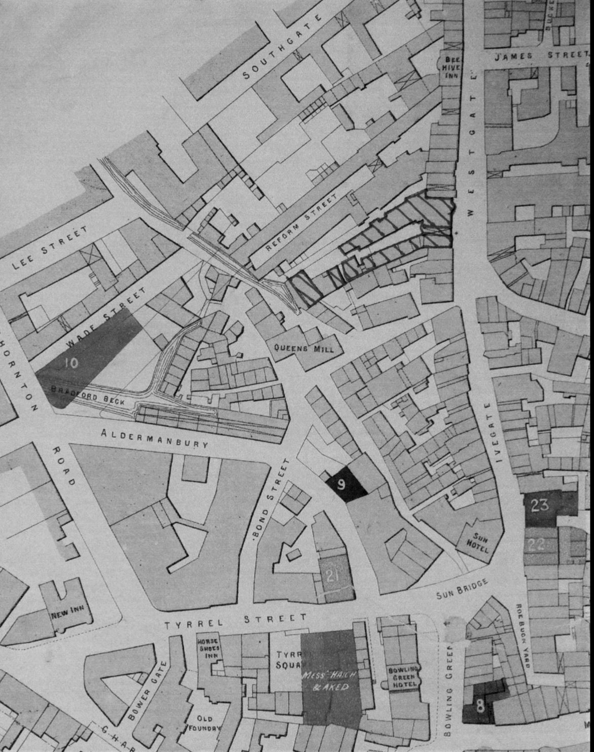
In the second map from the same collection I have hatched the buildings concerned to place them in a more general view of this part of Bradford in the years 1870-80. The creation of new thoroughfares, and extensive building redevelopment, results in a very different street pattern today.
map-of-the-week-016b

William Scruton, in his Pen & Pencil Pictures of Old Bradford included an illustration of the Bull’s Head itself. In this third image you may just be able to make out the design on the tavern sign. Neither drawing nor plans can be later than 1886 by which time the inn was no longer in existence, but it is likely that they are approximately contemporary. I know that there were other Bull’s Heads in Great Horton, Baildon, Thornton and Halifax and for this reason it is important compare images to check that everything matches up. The prominent features in the drawing are the projecting windows on either side of the door and the arched passageway which gave access to the rear of the property which was known as Bull’s Head Yard. These features are replicated in the plan, so there really can be little doubt that we are looking at a single building.

map-of-the-week-016c

Scruton says that at one time in front of this inn was a ring for bull-baiting, which presumably provided its name. Close-by was the town pillory in which offenders were manacled while being subject to the abuse of passers-by who could hurl eggs or fruit at them. I have seen a watercolour print which places the pillory on a wooden stage just about where the figure is sitting. This form of punishment was outlawed in 1830 and bull-baiting was forbidden after 1835. The Victorian historian William Cudworth, in his own account of the inn, doesn’t mention ball-baiting but says that in front of it was a market with rows of butchers’ stalls; another possible source for the name then. Whatever the truth there is not much doubt that Scruton was thinking of the situation in the late eighteenth century. At that time the Bull’s Head was used by merchants, manufacturers and woolstaplers. The first Bradford Club was founded there, according to Cudworth, in 1760. By the early nineteenth century a Mrs Duckitt was the host. She was apparently famous for her rum punch, which isn’t a beverage that I have ever tried. An Act of Parliament in 1805 appointed commissioners for levying rates and improving Bradford roads and lighting. These commissioners, a sort of primitive town council, met at the Bull’s Head. In some ways it was our first Town Hall. Apparently 60 years before Scruton’s book was published, which would therefore be in the 1830s, the inn was also a rendezvous for town and country musicians.

Inns are usually easy to trace in other Local Studies  resources such as trade directories and newspapers. I only wish I had more time for a more detailed study. The 1818 and 1822 commercial directories place Jeremiah Illingworth in charge at the Bull’s Head. It seems then to have then doubled as an Excise Office. In 1829 Hannah Illingworth, perhaps Jeremiah’s widow, ran the establishment which was clearly a large one since on one occasion in 1834 no less that fifty friends of Airedale College dined there together. On the other hand there are reports of fights in the street outside, and in 1837 a licenced hawker, Henry Stephens by name, was fined the huge sum of £10 for trying to sell a watch and razors in the bar parlour. Later that same year Joseph Sugden, who was now in charge, was reported as providing another excellent dinner, this time for 56 members of the Ancient Order of Oddfellows. Acceptable early Victorian dinners always seem to be described as ‘good’ or ‘excellent’ for some reason.

At the time of the 1850 Ibbetson directory Joseph Sugden was still the host. Manufacturers from outside Bradford would attend an inn on a regular basis so that they could be easily found if you wished to transact business. Among textile men at the Bull’s Head you could find John Anderton, manufacturer of Harden, and Samuel Dawson of Wakefield. Other visitors were Messrs Pilling, corn millers, and John Hirst, land agent, who attended on Thursdays. The LSL offers free access to the family history site Ancestry.UK and using this site it is not hard to find Joseph Sugden (47) in the 1851 Bradford census. He lives with his wife Sarah and two children, together with a charwoman, an ostler, and three servants. I assume he would also have non-resident staff. His immediate neighbours are: booksellers, druggists, drapers and plumbers.

Some of Sugden’s patrons must surely have come from the surrounding streets where wool-combing was a very common occupation. This trade was on the verge of being destroyed by the mechanical wool-combs developed in Bradford by Samuel Cunliffe Lister and Isaac Holden. The habits of those patrons is hinted at by the fact that in 1869 Thomas Burrows was arrested in Bull’s Head Yard in possession of two spittoons, thought to be the property of Thomas Waterhouse, then of the Inn. It remained a significant local building and in 1874 the Bradford Musical Union dined there, inviting the Mayor and local jeweller Manoah Rhodes as guests. I have followed entries for the inn in the Bradford Observer up to 1875, when it was being used for election candidates’ addresses.

The Bull’s Head is on the same alignment as Westgate, as indeed are all neighbouring premises. The rear yards however are aligned as an angle to the thoroughfare. This is also true in the much older 1800 map of Bradford. The yards and properties are running south-west following even earlier field boundaries. You may be able to see that the first map has been annotated in pencil. The annotations are not generally legible but they would appear to indicate the types of premises found in Bull’s Head Yard. The only proprietor I can be certain of is a Mrs Smiddles who ran a tripe shop, but there are also sheds and stables. I haven’t been very successful in tracking down any other businesses based there. In 1850 John Hebden, fishmonger, gave this address but the 1851 census shows he was actually living nearby in Reform Street which is clearly shown in the second map. Perhaps he had a shop in the yard combined with a house entered from the next street. In 1857 Tennand, Hall & Hill of Manchester, who were tanners and curriers, advertised that they visited Bull’s Head Yard weekly.

The Bull’s Head at 11 Westgate was still run by Joseph Sugden according to a 1866 trade directory. It is listed under the name J Halliday in the directory of 1879-80. In the directory of 1883 the inn is missing. The Lord of the Manor had the medieval right to a corn-milling monopoly at the Soke Mill, which had stood above Aldermanbury for centuries. Bradford Corporation bought out this right in 1870. In the mid 1870s clearance of much of the property in this area began, and modern Godwin Street was created. At the top of the first plan the elevation of various points is related to Sun Bridge Road. This would have been relevant during such a period of development. Does any of this area survive? I would imagine that everything was destroyed when Godwin Street was brought up to intersect with Westgate. Walking along Godwin Street and Sackville Street today, both in reality and using Google Earth, I cannot persuade myself that any of the mapped buildings are still present. But I should so very much like to be proved wrong.


Derek Barker, Local Studies Library Volunteer

Map of the week: Manningham village

It can be very difficult to orient yourself correctly when examining an old map. Map-makers often did not identify the direction of north and a building that would have provided an obvious fixed point, such as the parish church in the centre of Bradford, may not be drawn. The names of roadways may not be given, or if they are included they may differ from those known today. A plan of Manningham from the reserve collection exemplifies such difficulties.

The first image constitutes about half the original map which is annotated ‘late Miss Booth’s property, Manningham’. The crucial fact is that the road labelled as Lilly Croft Lane is now called Heaton Road. This thoroughfare leads from Bradford to Heaton, as the map indicates, in a direction that is a few degrees west of due north. Today there is another Lilycroft Lane, which is the road entrance leaving Heaton Road to the left. The block at the top left of the plan is a row of cottages, no longer existing, which were in front of the first Manningham Mill. This mill was rebuilt by Samuel Cunliffe Lister in 1873 after a disastrous fire. The mill building itself, which would have permitted instant positional recognition, is not drawn.

Moving east we cross the property of E.C.L. Kaye. He was Samuel Cunliffe Lister’s brother who retired early and took no part in the commercial life of Bradford. The field patterns here resemble closely those of the first OS map of the area; this was surveyed in 1847-50 and so provides an approximate date for our map. Skinner Lane in Manningham village has kept its name and the property outlines that are drawn again resemble those of the the first OS map. The road leaving the village to the east, and reappearing on the second image, is Dewhirst Lane.

map-of-the-week-014-b

In the first OS map this is called Duce Lane. I assume that Dewhirst is formally correct but that ‘Duce’ was a contraction by which it was generally known. Today it is Oak Lane. Whatever its name the lane ends at property belonging to Thomas & Isaac Rhodes. Here it joins Esp Lane, often called Hesp Lane, which evolved into North Park Road when the land  surrounding Manningham Hall was developed as a public open space (Lister Park) after 1870. Where you may just be able to make out the words ‘to Bradford’, at the bottom right of the image, is approximately the position of the beautiful Manningham Park gates. The road shown here links to Manningham Lane – Keighley Road, which is not drawn.

So, who was the late Miss Booth? As so often Cudworth provides the answer. He writes: (Skinner Lane) ‘was formerly the only outlet from Manningham to Duce Lane (now Oak Lane) which obtained its name from one Dewhirst (locally pronounced Duce) having long been resident there. In one square house, which is still standing in Skinner Lane, lived Jonas Booth with his maiden sister Catherine. Booth was one of the old race of stuff-makers, his warehouse being in the rear of his house. He died in 1837 bequeathing his property to his sister, who died the following year.’ Our map therefore presumably dates from 1838-39.

Derek Barker, Local Studies Library Volunteer

Map of the week: Leeds Road and Market Street

This current example of a map from the Local Studies Library’s reserve collection is taken from a sepia plan which shows the eastern part of Bradford some years before it became a borough. Firstly it would help if we could establish a date. It is far earlier than the first OS map of 1849. The ‘new road’, running diagonally across the centre of the map, later became known as Leeds Road. This dates the map to later than c.1825-30 during which years this new turnpike to Leeds was constructed by the Leeds & Halifax Turnpike Trust. The pattern created by the other ‘new roads’ portrayed also exists on the Bradford plan of 1830, so we are probably looking at a map from the late 1820s.

leeds-rd

A coal staithe is a place adjacent to a highway from which merchants can collect a supply for subsequent delivery to their customers. The staithe here is marked J.S. & Co. Clearly this represents John Sturges (or Sturgess) & Co. which was the company that operated Bowling Iron Works. There were two original partners of this name, father and son, but they were presumably dead by the time this map was created. The ‘new rail road’ drawn is in fact a mineral carrying tramway bringing coal in trucks to the Eastbrook staithe, by rope haulage, from the iron works. Bowling Iron Company owned and operated many collieries and ironstone mines. The trucks may have been returned filled with limestone, needed for iron smelting, which would have arrived at the nearby canal basin from the quarries at Skipton. The tramway was closed in 1846 and the area is marked as an ‘old staithe’ in the first OS map of the area.

Let us look at some other roads. Wakefield Road, Bridge Street, and Hall Ings are in their present positions. ‘Dead Lane’ has subsequently been renamed Vicar Lane. Leeds Old Road is now Barkerend Road. As far as I can tell the numbered areas represent fields. Trees are growing west of the first section of Leeds Road and a rather larger wood is mapped there in the 1800 Bradford plan. There is second coal staithe (or stay) at the junction of Well Street and Hall Ings. This is evidently operated by J.J. & Co. whom I cannot identify. At the opposite end of Wells Street is another ‘new street’ which had been in existence for some years and has evolved into Market Street. Behind this is a rather sketchily drawn Bradford Beck. The surveyor of the map was evidently interested in the owners of property between Market Street and the beck and has added some names. You probably won’t be able to read these names, and in fact they are not easily legible even on the original map. As far as I can make out, reading from top to bottom, the names are: Green, Cowling or Crossley, Bradford, Wilkinson, Bank, Armytage, L Lumb, and Hustler.

There are directories listing Bradford business in 1822 and 1834. Plausible identification of most of these names in Market Street can be made from these directories although it is impossible to be sure.

  • Thomas Green, grocer and tea dealer 1834
  • David Crossley, attorney 1834
  • Bradford – uncertain
  • James Wilkinson, cabinet maker 1822
  • Thomas Jowett Wilkinson, cabinet maker 1834
  • Bradford Commercial Bank Co. 1834
  • Samuel Armitage, plumber & glazier 1834
  • John Lumb, straw hat maker 1822
  • Ann Lumb, pawn broker 1822
  • Thomas Lumb, pawn broker 1834

The name Hustler is more difficult. The famous Quaker wool-stapler and canal promoter, John Hustler, had died 1790. I believe he left two daughters. The fact that Market Street boasted two wool-stapler partnerships carrying his surname cannot, surely, be a coincidence. The two partnerships were Hustler & Blackburn and Hustler & Seebohm and I have confirmed the existence of both in other sources. I know that the Seebohms were another Bradford Quaker family. Can anyone fill me in on the exact relationships?

Derek Barker, Local Studies Library Volunteer

Map of the Week: Allerton Stone Extraction

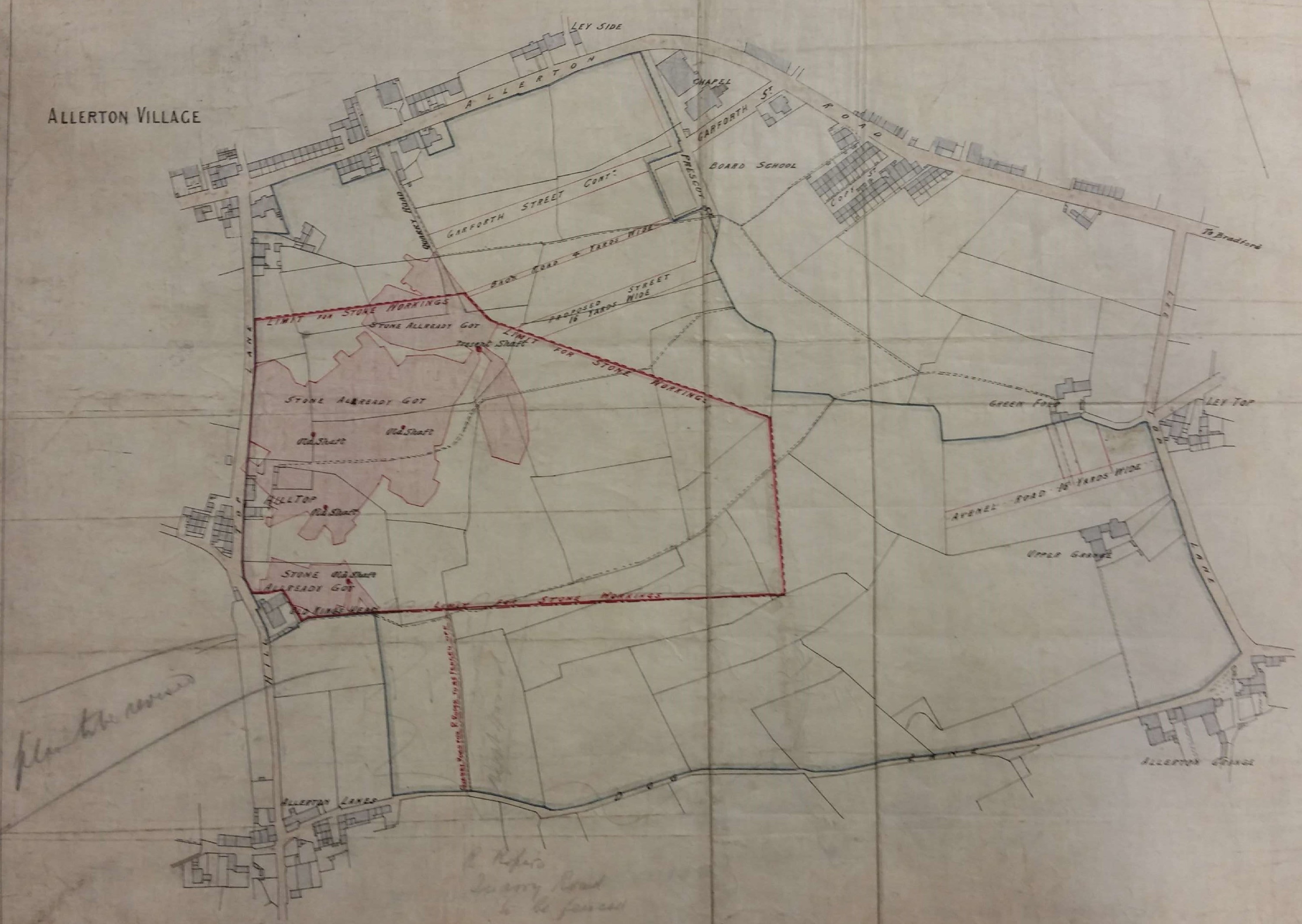
The minerals exploited within Bradford were ironstone, coal, fireclay and sandstone. At one time there was also a small lime industry, in Bingley and elsewhere, based on the excavation of glacial limestone deposits brought by the ice from the Dales. After the Shipley to Skipton section of the Leeds-Liverpool canal was opened in 1774 there was a more direct means of access to the Skipton limestone quarries.  Ice movements would presumably have left substantial quantities of hard stone on the surface. This would need to be removed before ploughing in any case, but in regions where drystone walls were the traditional field boundaries there must have been a ready use for such material. Elsewhere resistant outcrops of rock protruded through the top soil from which potential wall stone could be removed with a hammer or crow bar. On some common land, or waste, local people may have had the right to remove such surface stone deposits. In Northcliffe Wood in Shipley there are a number of undated shallow excavations by means of which a band of sandstone called Stanningley Rock was accessed.

In many parts of Yorkshire it would have been possible to rob a Roman fort or the ruin of a dissolved monastery to obtain building stone, but not here.  In Bradford ‘delvers’ could obtain a good quality, honey coloured, sandstone. Quarrying is thought to have begun in this area in the seventeenth century and continued until the twentieth. The need for stone was perhaps greatest in the period 1860-1900 although the walls of many stone buildings in that era would have had an inner skin made from locally produced brick, which was cheaper. Stone winning processes are illustrated in these two plans of Allerton from the LSL’s reserve map collection.

The first plan is of Allerton Grange Quarry. The dated workings are from 1875-76. Towards the bottom of the plan you can see an extraction track. On the full map the track leads to Grange Lane. This name has been crossed out and ‘Dog Lane’ substituted in pencil. Dog Lane it remained until the post-war housing development of the area. The quarry seems to be marked as Upper Grange in the second OS map of the area (surveyed 1891). In 1905 a cricket pavilion was sitting on the site but by the 1930s it was fields again.

map-of-the-week-012a

The second plan shows an area south of Allerton village & Allerton Road, east of Hill Top Lane and north of Dog Lane. An extensive area of stone exploitation is indicated which not present on the first or second OS maps, but is present on the 1908 map. This plan was drawn by J Hindle, a well-known Bradford surveyor in partnership at various times with Charles Gott and Thomas Dixon. It is undated but is probably from the last decade of the nineteenth century. The important feature is that this is a stone mine, not a quarry. You may just be able to make out four ‘old shafts’ and a single ‘present shaft’. The pink areas represent stone already won or ‘got’, and evidently the land-owner has imposed a strict boundary to the exploitation. Good stone was not infrequently mined. Recently I was shown round some old mining sites in Shropshire where limestone was obtained in this way.

map-of-the-week-012b

What rock was exploited in Allerton? The local geological guides record Elland Flags being mined there. This is a sandstone stratum consisted of several bands of varying thickness and quality which were located under the Better Bed coal seam, itself extensively mined in south Bradford. The maps include no evidence of ownership although nearby Allerton Grange Farm was on Atkinson-Jowett land. Contemporary trade directories list many stone merchants situated in Allerton any of whom could have been involved with these sites.

Derek Barker, Local Studies Library Volunteer

Map of the week: a century of Bradford Hailstones

As I work on the reserve map collection the same local land-owners appear regularly. Examples are: Rev. Godfrey Wright, Mrs Giles and Miss Dawson. Godfrey Wright owned a great deal of property around Bradford, but seemingly lived near Doncaster. ‘Mrs Giles’ was clearly a member of a family who owned much of Horton, and she sold the land on which the Bradford workhouse (later St Luke’s Hospital) was built. ‘Miss Dawson’ was probably Eliza Dawson, grand-daughter of Joseph Dawson, partner in the Low Moor Iron Company. The name of Samuel Hailstone also occurs regularly. His importance to Bradford, and his fame as a Yorkshire naturalist, will ensure that his memory stays green.

Samuel Hailstone (1768-1851) was that rare combination, a lawyer and a botanist. His brother John Hailstone MA FRS took holy orders and became a professor of geology at Cambridge. Samuel himself was born in Hoxton, London but his family soon moved to York. In time he became articled to John Hardy, a Bradford solicitor, and Hardy & Hailstone eventually became partners. John Hardy was elected an MP and was the father of another politician Gathorne Gathorne-Hardy who was created Earl of Cranbrook. I understand that Samuel and John Hardy were the moving spirits behind the 1803 Bradford Improvement Act. More than forty years before Bradford became a borough this act established commissioners with a variety of local government powers such as street cleaning, lighting, and water provision.

Samuel continued to practise as a solicitor and was later in partnership with the Thomas Mason who became a director of the Bolling Iron Company and lived at Bolling Hall (see the previous map). Samuel Hailstone was the classic example of a wealthy and highly successful professional man. His politics were Liberal and, slightly unusually for non-conformist Bradford, he was an Anglican. He purchased the Bolton House estate although he never resided there. I get the impression that Yorkshire botany and geology were Samuel’s main interests. A collection of more than 2000 plant specimens was passed to the Yorkshire Museum on his death. But despite these studies he was active in issues affecting his chosen town. He helped found the Bradford Literary & Philosophical Society and also the Mechanics Institute. He served as a major in the Bradford Volunteer Infantry and was clerk to the Trustees of the Leeds and Halifax Turnpike Road.

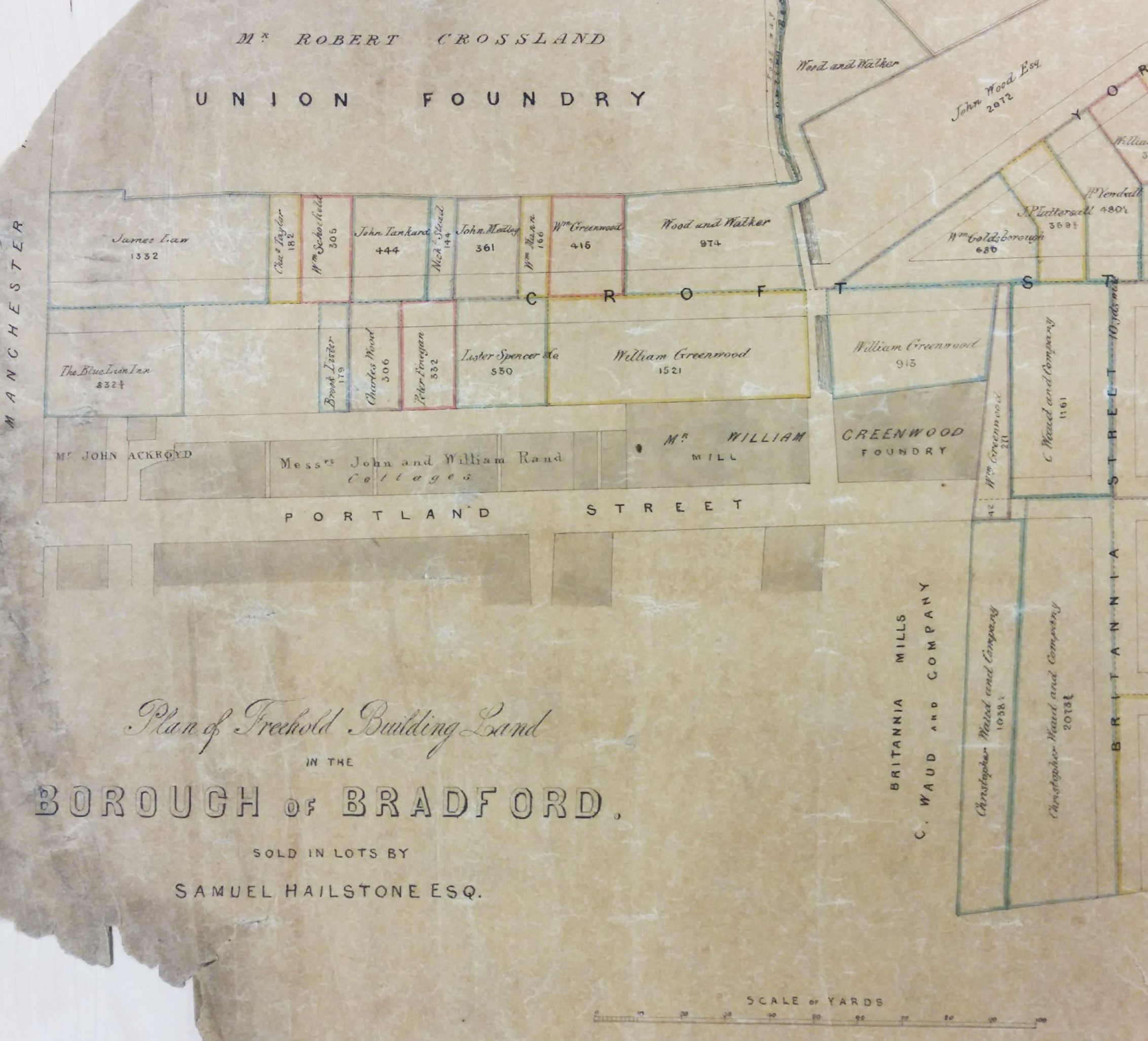
This brings us to the maps. In Samuel Hailstone 1837 he offered for sale the land between Croft Street & Bridge Street. A small portion of a very large sale plan is illustrated here.

Map of the Week 011A

A second map shows land further south which is also divided into lots. This map is stylistically very similar and shows Samuel’s place of business and house. What is now called Croft Street took its name from Croft House, in Bowling Lane (now Manchester Road) which was was where Samuel lived in his early years.

Map of the Week 011B

In 1808, quite late in life, Samuel married Ann Jones, the daughter of a Bradford surgeon, and the couple had several children.  Samuel died at Horton Hall, Bradford in 1851. In his census return for that year he indicates that he is living alone, except for a house-keeper and five servants.

The Hailstones were a very high achieving family. One son, Samuel jnr., was also a noted amateur naturalist and a collector of crustacea. He pre-deceased his father in 1841. There were two surviving sons, Rev John Hailstone (1810-1871), the vicar of Bottisham, Cambridgeshire, and Edward Hailstone FSA (1818-1890). Edward took over the Bradford legal practice but is famous for a huge assembly of books and documents relating to Yorkshire history, especially those of the Sharp family who were the previous owners of Horton Hall. This was the project of his retirement when he lived at Walton Hall, near Wakefield. At his death the collection was left to the archives of York Minster where it can still be consulted today.

Derek Barker, Local Studies Library Volunteer