Map of the Week: A View from the Bridge

The Queens Road bridge, which carries the traffic from Manningham over Canal Road towards Bolton, Eccleshill and Idle, was in place when the 1889 OS map of the area was surveyed. The Local Studies Library reserve collection has a map from 1880 which seems to have been part of the preparatory planning for this structure. Early users, descending from Manningham, would have seen on their right the railway line and Valley Road coming from Bradford, very much as now. To their left, approximately where a stone reclamation site is now located, was Manningham Station. This pre-dated the bridge and was, in the years 1868-1965, the first stop out of Bradford on the Midland Railway (later LMS) line. Manningham and Frizinghall stations were closed, well within living memory, by Dr Beeching. Subsequently Frizinghall station has been reopened.

The three maps included in this article, though all undated, are clearly from the mid-twentieth century.  Their relatively late origin has one great advantage inasmuch as their interpretation can be supported with photography.

The first map shows the situation on the city side of the bridge. To display the annotations correctly it has to be displayed with the city centre to the left of the map which doesn’t feel right to me. Valley Road should be running across the top of the plan but is not drawn. The canal is evidently ‘disused’ which places our plan quite certainly after 1922. The arrangement of the buildings resembles the 1930s OS maps quite closely, so that is a probable date.

Map of the Week 021 A

The curved building that is aligned on Station Road, unnamed in this map, is a wool-combing mill. The blue waterway is the Bradford Beck and the idea behind the map, which is not explained, may have been to show how the beck could be culverted and taken under Canal Road at a time when a new sewer was being constructed. The six circles, and the ancillary buildings between them, represent the Bradford Gas Works. You can see this arrangement clearly in an image on the Britain From Above website:

Valley Road Gas Works

Strangely the 1936 OS map does not name the Gas Works but does indicate that it was served by a network of railway lines which presumably distributed coal, arriving on trucks from the Midland Railway, to the coke ovens.

The second plan shows the same area but is orientated more naturally.

Map of the Week 021 B

The map is undated but in the list below the railway is identified as London Midland & Scottish so it clearly pre-dates nationalisation in 1948.  It is stamped ‘SG Wardley, City surveyor & engineer’.  I believe Wardley was in post around 1946-1960s.  Readers who have known Bradford longer than me will have their own views about whether the major city plan that he espoused produced bloom or blight. The great advantage of the second map is that land occupiers are clearly identified:

1 London Midland & Scottish Railway Company

2 Bradford Corporation

3 Bradford Corporation Street Drainage & Works

4 Bradford Woolcombers Mutual Association Ltd

5 Beck Properties Ltd

6 J F Raspin Ltd

7 The Bradford Corporation, Gas Committee

8 Wm. Whitaker & Co Ltd

9 R Clough & Co Ltd

10 The Bradford Corporation, Electricity Committee

Contemporary trade directories reveal that Raspin’s and Clough’s were both firms of commission wool-combers. The well-known Wm. Whitaker & Co Ltd were brewers until the 1920s but by the 1950s were bottlers and wine & spirit merchants. Unfortunately my limited research cannot place them securely in this position nor explain why they needed such a small patch of land. Can anybody help? Between Raspin’s mill and the Gas Works were three long-vanished roads: Hopwood St, Valley St and Valley Row. Small portions of the Bradford Beck are shown and the relationship of Canal Road with Valley Road is much clearer than in the first map. Towards the end of the 1930s gas production was abandoned at the Valley Road works which became exclusively a distribution centre. Production continued at Birks Hall works, Laisterdyke, eventually the largest in Yorkshire.

The final building on this map is the Valley Road Electricity Generating Station. I understand that its chimney was taller than the famous example at Manningham Mills. Its wooden-construction cooling towers were known as Davenport Towers. The works consumed millions of gallons of water, and hundreds of tons of coal, weekly. It had been built in 1896 and extended in 1939 and again in 1947.

In the Local Studies collection we have a plan of the whole Power Station of which the third map is a detail. The map is annotated ‘Electricity works, Canal Road’. The British Electricity Authority (Yorkshire Division) is recorded as the operator. I believe that this body was only in existence between 1948-55. The station was finally demolished in the mid-1970s.

Map of the Week 021 C


Derek Barker, Local Studies Library volunteer.

Map of the Week: Bolton Woods

These two sections from a Bradford Local Studies Library map are part of a sale plan of the Bolton Hall Estate dating from 1882. Among other things it advertises the availability of building land and stone quarries. The right side of image 1 joins the left of image 2. The map as a whole marks a transitional stage between rural and industrialised phases in the district. Some woodland remains but quarries are in action, roads are being laid out, and houses have been built. Frizinghall mill is drawn although this and its reservoir no longer exist. The Bradford canal spur has also gone now, although the canal bridges remain. The railway line already existed in 1882 and it would appear that the extension of Canal Road to Shipley is being suggested.

Map of the Week 020 AMap of the Week 020 B

I have to admit that I am not sure of the precise boundaries of Bolton Woods. It is to your right as you travel up Canal Road from Bradford to Shipley although the very high ground is occupied by the much more ancient townships of Bolton, Idle, and Wrose. The designation ‘Bolton Woods’  appears on the 1851 OS map but is probably naming the woodland only. I think we can be certain that Bolton Woods was neither an old community, nor a planned one: it ‘just growed’. William Cudworth treats the area as part of Bolton township and two more recent authors have developed his account:

        A History of Bolton in Bradford-Dale: RC Allan (ed), 1927, p.107.

        The Story of Bolton Woods and St Laurence’s Church : Mary Lister, 1980.

Both these books are available in the Local Studies Library although the second is kept in the stacks and will have to be fetched by a member of staff. Mary Lister (1922-85) was a noted local historian who was ex-President of the Bradford Historical & Antiquarian Society, and taught at Hanson School. As a further source of information I am indebted to Tony Woods for the unpublished findings of his study into the district’s coal mining.

There is general agreement then that the history of Bolton Woods is quite recent. Before 200 years ago the district was simply noted for fields and a magnificent woodland. There were no roads, only trails through the trees. Peat could be cut there for fuel and the was some question of whether the inhabitants of Bolton had the right of turbary on land lying about Bolton Old Hall. In 1624 Bolton Manor became the property of Thomas Walker. The Old Manor House was soon demolished and Bolton Old Hall erected a short distance away. The Stanhopes of Eccleshill bought the Bolton Hall Estate from Thomas Walker in 1648. Bolton Woods was one of the many districts of Bradford where coal extraction may well have had medieval roots. In 1699 Cudworth describes various freeholders entering into an agreement to extract coal. Coal features again in a 1746 lease: near Hollins Close John Whitaker leased land for £6-10s with a condition of the lease being an undertaking to remove the coal-pit hill when it was dispensed with. By 1750 land around Bolton Grange Field was apparently much broken up by attempting to get coals through trenches or ‘Day-holes’.

An Enclosure Act operated at Bolton Woods in 1819, and in 1825 Bolton Road was constructed.  By 1840 Walter Scott-Stanhope had inherited the estate and then sold it to his cousin Richard Watson of Springwood, Manchester. Watson’s Scottish bailiff equipped the farm and, according to Cudworth, by his efforts made it one of the best in the district. At first he grew wheat but later suggested that building stone might be more profitably extracted. The first modern quarry in Bolton Woods was opened by John Holmes and Thomas Dawson in 1853. In the later nineteenth century more organised extraction of the Hard & Soft Bed coal seams was undertaken in Bolton Woods. Shafts and ‘old shafts’ are present on early OS maps but no named collieries are indicated. In the late 1850s there seem to have been two companies: Handforth & Co, and Messrs Brogden & Co. Their enterprise was  known as Bolton Wood Colliery which had been leased by Richard Watson. It was under Navy Croft, Far Ellar Carr, Mid Ellar Carr, Nr Ellar Carr, Rough Ing, and part of the Woods.

You can identify these fields on the lovely sketch map Mary Lister drew for her publication. It shows the same area as the sale plan but is 25 years earlier and has a slight different orientation. Essentially it shows the land on which the village was later developed. The field name ‘Delf Close’ suggests that stone extraction pre-dated the nineteenth century; delph being a local name for quarry.

Map of the Week 020 C

Messrs Brogden was perhaps a partnership of miners extracting coal but their enterprise was dissolved by mutual consent (Bradford Observer, 18 June 1859). The majority of the men involved could not write but the literate James Brogden had been underground steward at Bunker Hill Colliery on Barkerend Road. A well-known Bradford brick-maker, Edward Gittins, is also involved at Bolton Brick Works in 1861 although I don’t know in what capacity. E. Handforth & Co. are listed as fire-brick and sanitary tube makers two years later in a single trade directory (1863). Elsewhere Handforth is listed as a ‘colliery owner and fire-brick manufacturer’. It is probable that the company bought up Bolton Wood Colliery and added a Firebrick works. In 1865 E. Handforth & Co were advertising in the Leeds Mercury for a firebrick moulder at Frizinghall, near Shipley. They seem to have sold up in 1867. The only product I can attest is a firebrick marked [..FORTH & CO BOLTON WOOD]. The extraction of coal was not always easy. Mr Woodhead of Eccleshill Potteries operated a mine in a field facing Home Farm in Hodgson Fold. It was worked by a horse-gin but failed due to flooding. In her book Lister mentions that a Bolton ‘Clay and Firebrick Works’, existed on the Shipley side of the Woods in a piece of land known as ‘Rough Ing’. When it closed it was replaced by Bolton Woods Shed (Woolcombers) which you can see on the first plan.

The ground now covered by village part of Bolton Woods was a part of the Bolton Old Hall estate purchased from Alfred Barton by three men called Holmes, Pullen & Constable as a building speculation for £11,000. John Pullen subsequently sold off Bolton Woods in small lots. Wilkinson Shann built first row of houses in Shann St. During this period the quarries were progressively developed and attracted workers to the area. The light yellow stone was purchased by Leeds for paving slabs and was used for buildings such as Manchester Town Hall and the Bradford Eye & Ear Hospital. In 1870 the construction of the defecation works at Frizinghall created additional employment opportunities and at the same time JT Riddiough opened a saw mill. In 1871  a highly influential man, Harry Stockdale, came to Bolton Woods from Long Preston. He was a builder and brick-maker and with George Lang he constructed Bolton Hall Road. In 1874 he was elected a councillor and was influential in the building of Bolton Woods first school. In a Yorkshire Directory for 1875 one entry for Shipley reads:  ‘Harry Stockdale, Bolton Woods Brick & Tile Works’. In the same year Mr H Stockdale was prosecuted for smoke nuisance from his brick kiln. Did he buy the premises of Handforth & Co? Strangely on 17 August 1878, the Leeds Mercury recorded that he appeared in court summoned by Bradford Corporation for the sum of £63.10s: this being the unpaid cost of sanitary works at his properties at Livingstone Road. Apparently he flew into a temper in the court, but was reprimanded and ordered to pay. Something unpleasant had clearly happened to a celebrated Bolton Woods resident. He died early in 1881. In the years before 1914 brick-making took place near the present children’s playground. There were also two rather rarer forms of industrial activity: a factory making glass marbles for Codd bottles and the Guana Fertilizer Works. The last coal-mining in Bolton Woods was in 1923 when Slater Bros worked a large day-hole in the hillside to north-west of Hodgson Fold. Apparently they had access to a 3 feet thick seam of poor quality coal but their colliery was soon abandoned. In 1956 Bolton Woods farm was finally sold for housing.

Derek Barker, Local Studies Library Volunteer

Map of the Week: Little Germany

The district known as Little Germany  is close to Bradford Cathedral. It is unquestionably one of the glories of the city being famous for a unique collection of magnificent, stone-built, Victorian textile warehouses. In many cases their original occupiers were German merchants, which provided the  name. In 1977 John S Roberts produced an invaluable short pamphlet entitled Little Germany which was my personal introduction to the history of the area. More recently Susan Duxbury-Neuman published Little Germany: a History of Bradford’s Germans (Amberley, 2015) which is full of information about the warehouses, and the merchants that owned them, with much else besides. Despite the existence of these excellent accounts I wondered if anything in the Bradford Local Studies Library reserve map collection could provide a useful additional ‘taster’.

On the 1800 map of Bradford the future Little Germany was a green field site. Fortunately two roads of that period, Church Bank and Vicar Lane (earlier Dead Lane) have retained their names, which makes the placement of the location on more modern maps relatively easy. Leeds Road, which originally formed part of the Leeds-Halifax turnpike, was created in the late 1820s or early 1830s. The Library has several plans showing portions of adjacent land. Some of these are in excellent condition but one has been subject to considerable deterioration.

The first plan here is essentially of the lower part of Little Germany. It shows the first Bradford Mechanics Institute which was founded in 1832 being aligned on Leeds Road. The plan is annotated on the back as ‘Colliers Close’. I have found no other record of this name but it is perfectly credible since coal was mined all over the city, and Roberts reports that building on some of the Little Germany sites was difficult because of old mine workings.

map-of-the-week-19a

A huge help in dating this first plan is that Bradford is referred to as a Borough, a status achieved in 1847. On the other hand the first OS map of the area, which was issued in 1851 and surveyed in the late 1840s, shows no sign of any new street development. If we said that the plan was from 1848-49 I do not suppose we should be far wrong. It is interesting to note that the area was the location of two blacksmiths and a joiner’s workshop. So in 50 eventful years the green fields of 1800 had been mined for coal, transected by a major road, and become the site of several small businesses and the first Mechanics Institute. Leeds Road on the plan, confusingly, is not the major route of that name but a short branch which was soon renamed Well Street. The name Lee Street was also soon changed, to Currer Street. There is a pencil annotation describing it as ‘Abram Street’, presumably another name that was considered. Field Street seems to have been so called originally and has retained its name. The owner of the land west of Vicar Lane, both north and south of Leeds Road, was Rev. Godfrey Wright (1780-1862). A detailed account of his life was included in the description of my previous map.

The second map is essentially the same but provides more information about the purchasers.

map-of-the-week-19b

The names recorded do not seem to be the same as those who were associated with the famous Little Germany warehouses 10-20 years later. I’m not certain if the parcels of land were sold on or whether the original purchasers simply leased the warehouses. In any case individual buildings will have had many owners and occupiers since their construction. Augustus Silvestro (AS) Sichel were a Manchester textile firm. Augustus’s son, Sylvester Emil Sichel, later lived at Shipley Grange. As early as 1856 Sichel Bros were trading in Well Street. I’m not sure what their relationship was with Victor Sichel, manager of Reiss Brothers yarn and stuff merchants in Currer Street. Victor was the father of the Bradford artist Ernest Sichel (1862-1941). Both families originated in Frankfort am Main, Germany but were they directly related? Thomas Mills was a Bradford furniture merchant and upholsterer. Thomas Fison was in the partnership of Fison & Lister, wool merchants at Well Street. Nicholas Hermann Heydemann (1817-89) was both a cloth merchant and the German Consul. He is buried at Undercliffe cemetery. In 1859 on his land at 4 Currer Street the premises of Nathan Reichenheim, yarn merchants, was constructed. This is probably the oldest of the surviving buildings. In 1874 on GB Smith’s site at the junction of Field Street and Vicar Lane was built Law Russell’s magnificent Victorian warehouse. This was constructed by Bradford contractor Archibald Neill. Both these buildings were designed by the famous Bradford partnership of Lockwood & Mawson.

The third plan is severely damaged. The section reproduced indicates that the main interest of the surveyor was surface water drainage from Burnett St, Cator St, and the upper part of Currer Street.

Map of the Week 19C.jpg

The original land-owner is not recorded but these lands to the east of Vicar Lane were part of the Vicarage Trust. I do not know if the vicar at this period, John Burnett, benefited personally from land sales but he presumably gave his name to the street. Another series of purchasers are recorded. Leopold Reiss has already been mentioned as one half of Reiss Brothers. As far as I can tell William Bollans and James Wilman were both publicans in other parts of Bradford. Eli Milnes (1830-1899) was the leading warehouse architect. He designed several of the warehouses and the fact that one carries his EM monogram suggests that he was also involved in speculative construction. Not all the land-owners are traceable. Jacob Philipp & Co. seems to have puzzled Duxbury-Neuman and certainly defeated me.  Roberts explained that most of the building occurred in the period 1860-67. The Borough Map of 1871 shows the whole area completely filled with buildings. I imagine that by 1875 the appearance of Little Germany was very much as it is today although one or two later premises were still to be constructed. Most still survive and if you are not familiar with Little Germany do please experience its delights for yourselves.


Derek Barker, Local Studies Library Volunteer

Map of the Week: Askwith & Rev. Godfrey Wright

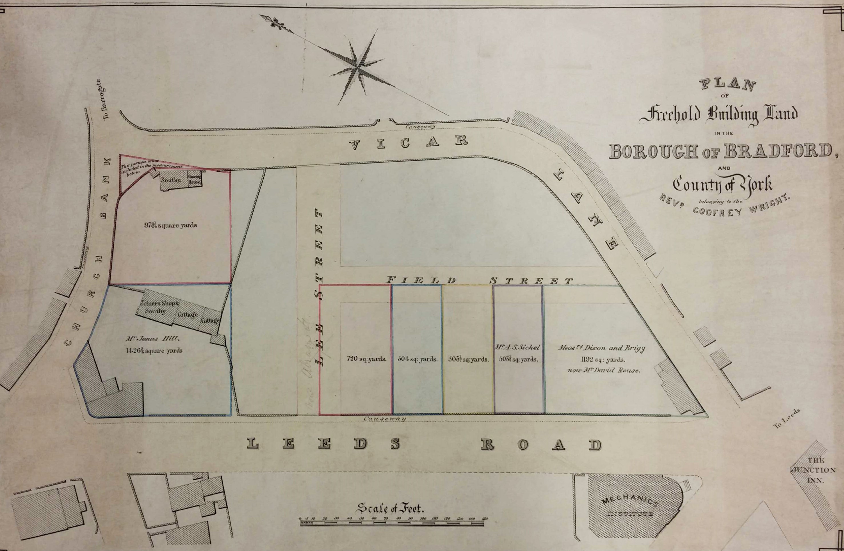
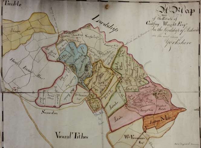
If, like me, you spend time studying nineteenth century maps of the Bradford district you are certain to have come across the name of Godfrey Wright as a landowner. Rev. Godfrey Charles Wright (1780-1862) possessed property in what would later become the the city centre but also at Horton, Manningham, Baildon, Eldwick and elsewhere. As a representative of all these maps I have selected, from the Local Studies Library reserve collection, this beautiful plan of Askwith which is a village between Ilkley and Otley north of the Wharfe valley. The plan employs different colours to designate the fields of several tenants but the landowner is clearly Wright.

map-of-the-week-018

Stylistically this looks like a late eighteenth or early nineteenth century plan. Wright’s title is not used which also suggests an early date, before his ordination. He was awarded a Cambridge University MA in 1807 and presumably became a clerk in holy orders a few years later, although I don’t have an exact year for this. Wright does not seem to have lived in Bradford for any prolonged period, if at all. Certainly by 1822 was resident at Bilham House, Hooton Pagnell, near Doncaster, where he remained for the next 40 years. In census reports he described himself as a ‘clergyman without cure of souls’, and had an indoor and outdoor staff of a dozen or more. According to newspaper reports he subscribed to Leeds Infirmary and Bradford Infirmary, and was a member of the Camden Society with, presumably, an interest in early British history. He was described after his death as a staunch Conservative and he left to his heirs a substantial fortune. It is very natural to wonder how a clergyman acquired all this property.

Victorian Bradford historian William Cudworth believed that Godfrey Wright’s wealth resulted from a relationship with three local families: the Swaines, the Fields, and the Booths. That there was such a connection is certain since Wright used all three surnames as his own sons’ middle names. A collection of Wright papers in the West Yorkshire Archives (Bradford) contains much earlier material relating to the Swaines and Booths. Cudworth also suggested that Wright benefited indirectly from the estate of Abraham Sharp of Horton Hall, the famous mathematician. This is true but the amount involved may not have been significant. There is little doubt that, however he acquired them, the fields and cottages in his possession became substantially more valuable as space in an expanding Bradford became increasingly necessary for new roads, mills, dwellings and public buildings. Wright owned the land on which Little Germany and St George’s Hall were eventually built, for example. Consequently Wright reaped a substantial fortune from the prosperity of the Bradford borough, a fact that evidently had occurred to his contemporaries if newspaper reports are to be believed. The development of Little Germany is a particularly interesting story and one to which I must return in the future. Godfrey Wright left £80,000 at his death in 1862 which equates, according to the National Archives currency converter, to £3,452,800 at 2005 values.

You will, I am sure, have heard of Abraham Sharp who was a distinguished mathematician and scientist. He lived and worked at Horton Hall in Little Horton Green but sadly the hall was demolished many years ago. Cudworth mentions a certain ‘Dr Swaine of Hall Ings’ who was an eminent apothecary and a great friend of Abraham Sharp. There is also a Swain (sic) tablet in Bradford cathedral. It commemorates William Swain of Bradford and his family:


William Swain                                                     d.1737 aged 71

Son,  William                                              d.1715 aged 20

Son,  Abraham                                            d.1732 aged 34

Abraham Swain (brother of elder William)               d.1731 aged 58

Son, Abraham                                            d.1733 aged 28

I think it is reasonable to assume that only wealthy families of some consequence had commemorative tablets inside the old Parish Church. The monument was erected by Mary and Elizabeth Swain, co-heiresses of the family. Mary seemingly stayed single but Elizabeth was to make a significant marriage.

George II became king in 1727. The following year, according to a West Yorkshire Archives indenture, two spinsters Elizabeth & Beatrix Field (daughters of William Field ‘late of Bradford’) are involved financially with an Abraham Swaine. He is possibly the elder man of this name on the Parish Church tablet. The document mentions a great many fields, barns and dwellings. Some familiar place names are: Goodman’s End, Silsbridge and Penny Oak, all in Bradford. One dwelling is occupied by ‘the widow Beatrix Field’ who is likely, I suppose, to be the girls’ mother. Clearly the Field family must also be linked to Godfrey Wright if their family papers ended up in his archive.

Remember the two Swaine girls, Mary & Elizabeth? Mary Swaine may be the ‘Aunt Swaine’ who lived in Hall Ings, dying in 1759. Her sister Elizabeth Swaine definitely married Rev Charles Booth snr. They had a number of children including Charles Booth jnr. who was born in 1734. Fortunately the will of Rev Charles Booth snr. survives in the West Yorkshire Archives. Amid the legal language there are three important facts: Rev Charles Booth was a wealthy man himself with much cash and property. Sarah & Beatrix Booth were his only surviving daughters who were left £500-£1000 each, which would be hundreds of thousands of pounds in a modern money equivalent. Finally, Charles Booth jnr. was his only surviving son being made executor, land inheritor and residuary legatee. The lands involved were in the parishes of Halifax and Bradford although the only names I am certain about are Ovenden and, I am glad to say, Askwith. I think then that we can be certain that the plan I have selected displays property that Godfrey Wright eventually inherited from Charles Booth jnr.

Charles Booth jnr. was a wealthy young barrister. He changed his name to Charles Swaine Booth after inheriting yet more property from his aunt who, as I say, was presumably Mary Swaine of Hall Ings. By this means I believe he obtained the whole of the Booth and Swaine inheritances but he had one more piece of financial luck, and one more name change, to come. A lady called Hannah Gilpin had already changed her own name to Hannah Gilpin Sharp. Essentially Hannah had inherited Abraham Sharp’s Horton estate via his niece Faith Sawrey who died in 1767 without any children. As you may have guessed Charles Swaine Booth married Hannah. After 1769 the couple lived together at Horton Hall under their final married names of: Charles SB Sharp (1734-1805) & Hannah Gilpin Sharp (1743-1823). The custom at the time would have been for Charles to have acquired control of his new wife’s considerable wealth. A married woman could not own property of her own but in rich families her future could be protected by a marriage settlement, which was in some ways like a modern pre-nuptial agreement. Under such a settlement some property was placed in the hands of trustees who would manage it to provide an income for a wife or, in due course, a widow. Thus the interests of a wife would be protected if the husband was a poor businessman, or developed expensive hobbies like drinking or gambling. She was, of course, still dependant on the business acumen of the trustees but rental properties or consolidated stocks will have represented secure investments.

A marriage settlement between Charles and Hannah survives and Hannah seems to have been well provided for after her husband’s death in 1805. When he died Charles had no living brothers or children and was clearly in need of an heir. He seems to have left his own considerable property to his sisters Sarah & Beatrix, but when in turn they died without children control of the inheritance was passed to Godfrey Wright although on the face of it he was a rather distant family member. The closest common relative would appear to be the Rev Marmaduke Drake, a vicar in Derbyshire, who was Godfrey Wright’s great grandfather and who married a Field. If any local historian has studied his extended family I would be pleased to learn more.

Godfrey Wright was born in 1780 at Kimberworth, Rotherham and educated at Hipperholme Grammar School (like Sir Robert Peel) and Trinity College, Cambridge after 1799 (MA 1807). He married in 1812, at Huddersfield, Mary Stables (1790-1821) but his wife died at Bath while still a young woman. Wright was already described as being ‘of Bilham House’. He frequently visited Bath, York & London for the season according to contemporary newspapers. He was also Lord of the Manor of Marton, Sinnington, near Pickering, NRY. In the 1800s his land agents were reported as being Joseph Smith and then Thomas Hirst of Hall Ings, Bradford. Wright was involved in a legal action, Rawson v. Wright, brought by the Lord of the Manor against him in 1825 for the erection of the Waterloo market in Hall Ings (Charles St). Rawson won although Cudworth records that Godfrey Wright attracted considerable public sympathy since more market accommodation was certainly needed in Bradford. Wright was also involved in some controversy over paving Hall Ings in 1836.  In 1850 he owned the land on which a public hall (St George’s) was built and got £15,000 for it (Bradford Observer October 17 1850). The Bradford Observer February 26 1857 stated that he owned The Beehive Inn and other ‘low’ dwellings in the Silsbridge Road area. This Beehive estate was eventually purchased by the Council from his trustees for £5,775, in 1864.

Cudworth states that Hannah Gilpin Sharp (aka Madam Sharp) long outlived her husband finally dying in 1823 at the age of eighty. Godfrey Wright didn’t inherit the Sharp property although he was executor of, and beneficiary from, Hannah Gilpin Sharp’s will. The Hall and the associated land went to Mrs Ann Giles, who also figures regularly as a landowner in maps of Bradford and Horton. I assume that this property was managed for her by trustees. My conclusion is that in the nineteenth century people could do well financially by surviving and being prepared to change their surnames. If you want to learn the fascinating history of Horton Hall, both before and after Charles Swaine Booth and Hannah Gilpin Sharp, you must read the excellent Sharp to Blunt by local historian Astrid Hansen (Bradford Libraries, 2000). Copies are available in the library.

Derek Barker, Local Studies Library Volunteer


Map of the week: The Bull’s Head Inn, Westgate

It is relatively unusual to be able to match plans with a surviving drawing. The first image is a map in the Local Studies Library reserve collection which plots a strip of land extending from Westgate, near the city centre, down to the old goit which once supplied the Soke Mill (or Queen’s Mill) with water. Very helpfully it unmistakably identifies a building called the Bull’s Head Inn.

map-of-the-week-016a

In the second map from the same collection I have hatched the buildings concerned to place them in a more general view of this part of Bradford in the years 1870-80. The creation of new thoroughfares, and extensive building redevelopment, results in a very different street pattern today.

map-of-the-week-016b

William Scruton, in his Pen & Pencil Pictures of Old Bradford included an illustration of the Bull’s Head itself. In this third image you may just be able to make out the design on the tavern sign. Neither drawing nor plans can be later than 1886 by which time the inn was no longer in existence, but it is likely that they are approximately contemporary. I know that there were other Bull’s Heads in Great Horton, Baildon, Thornton and Halifax and for this reason it is important compare images to check that everything matches up. The prominent features in the drawing are the projecting windows on either side of the door and the arched passageway which gave access to the rear of the property which was known as Bull’s Head Yard. These features are replicated in the plan, so there really can be little doubt that we are looking at a single building.

map-of-the-week-016c

Scruton says that at one time in front of this inn was a ring for bull-baiting, which presumably provided its name. Close-by was the town pillory in which offenders were manacled while being subject to the abuse of passers-by who could hurl eggs or fruit at them. I have seen a watercolour print which places the pillory on a wooden stage just about where the figure is sitting. This form of punishment was outlawed in 1830 and bull-baiting was forbidden after 1835. The Victorian historian William Cudworth, in his own account of the inn, doesn’t mention ball-baiting but says that in front of it was a market with rows of butchers’ stalls; another possible source for the name then. Whatever the truth there is not much doubt that Scruton was thinking of the situation in the late eighteenth century. At that time the Bull’s Head was used by merchants, manufacturers and woolstaplers. The first Bradford Club was founded there, according to Cudworth, in 1760. By the early nineteenth century a Mrs Duckitt was the host. She was apparently famous for her rum punch, which isn’t a beverage that I have ever tried. An Act of Parliament in 1805 appointed commissioners for levying rates and improving Bradford roads and lighting. These commissioners, a sort of primitive town council, met at the Bull’s Head. In some ways it was our first Town Hall. Apparently 60 years before Scruton’s book was published, which would therefore be in the 1830s, the inn was also a rendezvous for town and country musicians.

Inns are usually easy to trace in other Local Studies  resources such as trade directories and newspapers. I only wish I had more time for a more detailed study. The 1818 and 1822 commercial directories place Jeremiah Illingworth in charge at the Bull’s Head. It seems then to have then doubled as an Excise Office. In 1829 Hannah Illingworth, perhaps Jeremiah’s widow, ran the establishment which was clearly a large one since on one occasion in 1834 no less that fifty friends of Airedale College dined there together. On the other hand there are reports of fights in the street outside, and in 1837 a licenced hawker, Henry Stephens by name, was fined the huge sum of £10 for trying to sell a watch and razors in the bar parlour. Later that same year Joseph Sugden, who was now in charge, was reported as providing another excellent dinner, this time for 56 members of the Ancient Order of Oddfellows. Acceptable early Victorian dinners always seem to be described as ‘good’ or ‘excellent’ for some reason.

At the time of the 1850 Ibbetson directory Joseph Sugden was still the host. Manufacturers from outside Bradford would attend an inn on a regular basis so that they could be easily found if you wished to transact business. Among textile men at the Bull’s Head you could find John Anderton, manufacturer of Harden, and Samuel Dawson of Wakefield. Other visitors were Messrs Pilling, corn millers, and John Hirst, land agent, who attended on Thursdays. The LSL offers free access to the family history site Ancestry.UK and using this site it is not hard to find Joseph Sugden (47) in the 1851 Bradford census. He lives with his wife Sarah and two children, together with a charwoman, an ostler, and three servants. I assume he would also have non-resident staff. His immediate neighbours are: booksellers, druggists, drapers and plumbers.

Some of Sugden’s patrons must surely have come from the surrounding streets where wool-combing was a very common occupation. This trade was on the verge of being destroyed by the mechanical wool-combs developed in Bradford by Samuel Cunliffe Lister and Isaac Holden. The habits of those patrons is hinted at by the fact that in 1869 Thomas Burrows was arrested in Bull’s Head Yard in possession of two spittoons, thought to be the property of Thomas Waterhouse, then of the Inn. It remained a significant local building and in 1874 the Bradford Musical Union dined there, inviting the Mayor and local jeweller Manoah Rhodes as guests. I have followed entries for the inn in the Bradford Observer up to 1875, when it was being used for election candidates’ addresses.

The Bull’s Head is on the same alignment as Westgate, as indeed are all neighbouring premises. The rear yards however are aligned as an angle to the thoroughfare. This is also true in the much older 1800 map of Bradford. The yards and properties are running south-west following even earlier field boundaries. You may be able to see that the first map has been annotated in pencil. The annotations are not generally legible but they would appear to indicate the types of premises found in Bull’s Head Yard. The only proprietor I can be certain of is a Mrs Smiddles who ran a tripe shop, but there are also sheds and stables. I haven’t been very successful in tracking down any other businesses based there. In 1850 John Hebden, fishmonger, gave this address but the 1851 census shows he was actually living nearby in Reform Street which is clearly shown in the second map. Perhaps he had a shop in the yard combined with a house entered from the next street. In 1857 Tennand, Hall & Hill of Manchester, who were tanners and curriers, advertised that they visited Bull’s Head Yard weekly.

The Bull’s Head at 11 Westgate was still run by Joseph Sugden according to a 1866 trade directory. It is listed under the name J Halliday in the directory of 1879-80. In the directory of 1883 the inn is missing. The Lord of the Manor had the medieval right to a corn-milling monopoly at the Soke Mill, which had stood above Aldermanbury for centuries. Bradford Corporation bought out this right in 1870. In the mid 1870s clearance of much of the property in this area began, and modern Godwin Street was created. At the top of the first plan the elevation of various points is related to Sun Bridge Road. This would have been relevant during such a period of development. Does any of this area survive? I would imagine that everything was destroyed when Godwin Street was brought up to intersect with Westgate. Walking along Godwin Street and Sackville Street today, both in reality and using Google Earth, I cannot persuade myself that any of the mapped buildings are still present. But I should so very much like to be proved wrong.


Derek Barker, Local Studies Library Volunteer