Map of the Week: Toads and Chapels

In the 170 years since Bradford became a borough, in 1847, its centre has changed almost beyond recognition. New buildings have been erected and old ones demolished. The Bradford Beck has progressively vanished underground into culverts.  New roads have been created (Sunbridge Road being a good example), while others have been repositioned, lengthened, or have disappeared entirely. Change has been a continuous process but it was accelerated in the 1960s when there was a wholesale city centre redevelopment associated with the name of SG Wardley, the City surveyor and engineer. I should like to recount something of this story by describing the events that befell a thoroughfare called Chapel Lane.

Map of the Week 028 A Final

Image 1

I thought I had made a good start with the this first plan, which is widely reproduced and purports to date from 1800. Here it is easy to see the acute angle made by the Turls (Tyrrel Street) and Chapel Lane/Toad Lane. Toad Lane is an odd name but it is not unique; there are, or were, Toad Lanes in Bingley, Newark and Rochdale. Possibly the name is a corruption of ‘t’owld’ lane: certainly in Bradford the lane is drawn, but not named, on a map as early as c1722. On the above plan building (3) is the Unitarian Chapel which was certainly in existence at this time. An existing town hall is numbered (35) on the map but there is a small puzzle here. The Act of Parliament that appointed commissioners for levying rates, and improving Bradford roads and lighting, was only passed in 1805 and no town hall was to be built for decades. I am very obliged to local historian Kieran Wilkinson who explained this apparent anomaly by telling me that the map of 1800 is not contemporary but was a creation of the late nineteenth century, and marked places both where important local buildings were in 1800, and would be in the future. Let us instead look at a detail from a map that is believed to be contemporary, that of 1802, which is available in the Local Studies Library.

Map of the Week 028 B Final

Image 2

I do not think that there is much doubt that the second plan was the origin of the first, but there are some difficulties here too. Firstly Toad Lane is not mentioned. Kieran tells me that the shortening of Toad Lane, to that unnamed portion that leaves Chapel Lane at a right angle to join Bowling Green, happened in August 1804. The town’s board of commissioners changed both it and the names of a number of other roads in the town (Bank Street, Bridge Street, Market Street and Well Street being introduced as names then). Secondly although there is a Chapel Lane there is no obvious chapel. In his Pen & Pencil Pictures of Old Bradford William Scruton gives a full account of this building, originally constructed in 1717. Much of its material came from Howley Hall, Batley and the land on which it stood was donated by the Sharp family of Horton Hall. The names was originally the Toad Lane Presbyterian Chapel. The old chapel lasted about 150 years and for much of this time was located ‘amid green fields’. The chapel was replaced by a larger more modern structure in 1869, and finally demolished a century later. The most notable figure to be connected with the institution was Rev. Joseph Dawson who is closely associated with the exploitation of the mineral wealth of Low Moor. One possible explanation of the difference between the two maps is that the 1800 marks the position of the 1869 rebuild whereas in 1802 the chapel formed part of the block drawn immediately south of the first section of Chapel Lane. Unfortunately this simple explanation cannot be correct. A chapel, but with no denomination provided, is mapped here c1722, which is in accordance with Scruton’s statement, and the following detail from a map of 1825, surveyed by L Atkinson, clearly illustrates the same building. Here the building numbered (8) is identified on the map rubric as the Unitarian Chapel.

Map of the Week 028 C Final

Image 3

I have already mention the Bradford commissioners. This early embryo town council are said to have originally met at the Bull’s Head Inn, Westgate. At the first meeting according to historian Horace Hird, Lord Mayor (1951-52), the commissioners drew up that list of Bradford roads. The same commissioners moved to the ‘Station House’ in Swaine Street after it was erected in 1838. They did not change landlord since the Bull’s Head and the Station House were both built on land leased from Rev. Godfrey Wright who regularly features in this articles.  The final building I want to mention is the Bowling Green Hotel, which completes what I shall call ‘the central triangle’. This hotel was located at the end of Bridge Street. Cudworth mentions that in the 1830s its owner was a Mrs Susannah Ward, widow of Joseph Ward. William Scruton pushes the Bowling Green’s existence still further back into the seventeenth century. He regarded it as ‘the best inn of the town’. It was used by the Royal Mail and the open space in front of the inn, which presumably was once a bowling green, came to be employed for political meetings. The road names remain unchanged until the mid-nineteenth century, which is represented by the next map from the Local Studies Library reserve collection.

Map of the Week 028 D Final

Image 4

It is perfectly clear that there has been extensive construction in the central triangle.  The Bradford Observer (1844) observed that the premises of DH Smith at the corner of Toad Lane were ‘striking and elegant’. Elsewhere a ‘Smith’s Tavern and Beer-house’ is noted which I assume was the same building. Other developments were evidently far from elegant. In 1847 the Poor Law Commissioners considered Chapel Lane a possible site for a ‘vagrants yard’, and in 1855 a ton and a half of ‘vile bones’ were removed from the premises of John Boyd. The Lund’s 1856 Directory of Bradford lists John Boyd as a ‘rag dealer’. The same source gives Rev. JH Ryland as the non-resident minister at the chapel. There is also an architects’ partnership (Stott & Illingworth) and a painter (John Edwards), but otherwise the Chapel Lane residents are all tradesmen: plumbers, hair dressers, bootmakers, saddlers, pawnbrokers and so forth. Was the ‘Old Foundry’ (Cliff’s Foundry) drawn on the second map still functioning in the town centre? According to Hird it was.

The new unnamed cut-through joining Chapel Lane and Tyrrel Street  is Bower Gate. Toad Lane makes an acute angle with Norfolk Street. Kieran Wilkinson tells me that Toad Lane was ‘stopped up’ in 1869 to assist with the subsequent Town Hall development. The Bradford Daily Telegraph of 10 September 1873 recalled that Toad Lane was a ‘narrow passage… immediately behind Garth’s warehouse’. According to the Bradford Observer of 17 March 1869, the width of Toad Lane was only three and a half yards. The next development, which I have already hinted at, represented a huge change. Bradford Borough Council decided that a purpose built Town Hall was required to support the rapidly growing urban area. A number of sites were considered but Chapel Lane or the Bowling Green were the front runners. Finally a competition was launched to design a hall to be built on the Chapel Lane site. The winning design was opened by the Mayor, Matthew Thompson, in 1873. The architects were the famous partnership of Lockwood & Mawson who had already designed the Wool Exchange (1867). The contractor was John Ives of Shipley. In his book Bradford in History Horace Hird described the whole process and provided illustrations of the runners-up. It seems that all the considered designs were for Gothic buildings including a tower. The stone for the winning design came from Cliff Wood quarries but at present I do not have sources for the glass, metal work and ornamental marbles, nor the million bricks incorporated into the structure. The Unitarian Chapel and Chapel Lane itself were left alone during this development, but Bradford became a city in 1897 and the increase in council business required an extension to the Town Hall, opened in 1909. This provided more committee rooms and a banqueting hall. The designer was Richard Norman Shaw. As you can see from the map below only a stub of Chapel Lane remained after the completion of this extension, and the chapel is now south of Town Hall Square. A further extension was constructed in 1914 but this does not seem to have affected the plan of the building which is essentially the same in the 1930 OS map with Chapel Lane now opening off Norfolk Street. The nearby Alhambra Theatre was to be built at the same time.

Map of the Week 028 E Final

Image 5

Understandably these events drastically reduced the number of occupants of Chapel Lane. Even before the extension was built the PO 1898 Directory indicates that, besides the city’s conditioning house, health office and water testing department, there were just five textile related premises, and a produce merchant. Chapel Lane and the Unitarian chapel survived until the reorganisations of the late 1960s when wholesale clearances took place. These must have been required to create the space that became Centenary Square, the Magistrates Court and Coroner’s Office building, the Norfolk Gardens and the Hall Ings extension. The court building, which was opened in 1972, retains ‘The Tyrls’ as its address. What remained of Chapel Lane ultimately gave way for Norfolk Gardens. However Kieran feels that it is arguable that some of Chapel Lane remains within the Town Hall as there is an outside area between the original Town Hall and the extension which was part of this lane.


Derek Barker, Local Studies Library Volunteer


Map of the Week 027: What was going on in Great Horton?

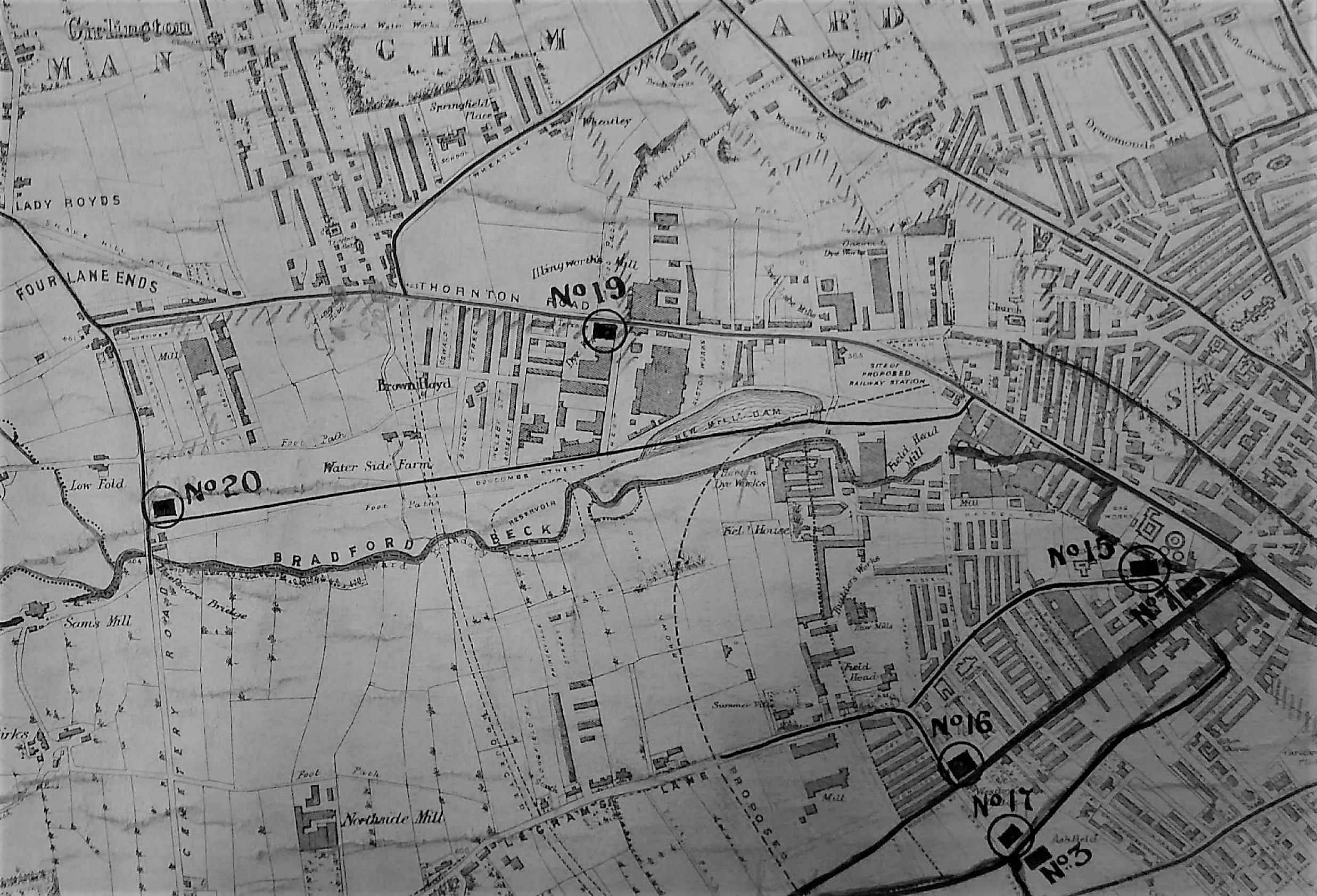
If you are reading this article you probably find maps and plans as interesting as I do. You will certainly understand how easy it is to get distracted, while writing a brief report, by trying to identify all the recorded features and resolve some of the inevitable puzzles. The first image is a detail of a map in the reserve collection which is in poor condition. The parent map is the one produced of the Borough of Bradford in 1873 by Walker & Virr, which is especially valuable since it falls evenly between the two first Ordnance Survey maps of the 1850s and 1890s. The twenty years that preceeded the Walker & Virr map brought huge changes to Horton. In 1850 the community had been surrounded by many coal and ironstone pits, both functioning and disused. Tramways conveyed their products to the Low Moor Ironworks for conversion into best Yorkshire wrought iron. By the 1870s the seams were exhausted, the pits were closed, and there had been considerable housing development.

Map of the Week 027 A

A map detail showing Great Horton watercourses and main sewers

This map was in a group that evidently came to the Local Studies Library from the city’s Surveyors and Engineers Department. Its purpose is clearly recorded, this being to record Bradford’s main sewerage system and to show storm overflows. The main sewers collected both foul water and surface water. During a rainstorm they could become completely filled. Under those circumstances the plan was for the excess to flow into alternative sewers and ultimately watercourses like the Bradford Beck; not a pretty thought. The positions of the storm overflows are more easily displayed in a second map detail.

Map of the Week 027 B

A detail from the same map showing sewers in the area between Thornton Road and Legrams Lane

The Borough Surveyor (B.Walker) employed this map. It was clearly being used for at least a decade after its first publication since pencil annotations are dated for the years 1881-83. Having dated the map and identified its use I thought that there were three features of particular interest: the Old Mill, Bracken Hall, and the brick works.

The longer watercourse in the first image is the Horton Beck which provided the water for the Old Mill. A little further down stream, out of sight, was a second corn mill called the New Mill. I assume that the Old Mill started life as a manorial watermill, like Bowling Mill or the Bradford Soke Mill. William Cudworth records that in the nineteenth century the Lord of the Manor of Horton was Sir Watts Horton and then, after his death, his son in law Captain Charles Horton Rhyss. His property came up for sale in 1858 when William Cousen of Cross Lane Mill purchased the lordship. The Old Mill, its farm, and the water rights went to Samuel Dracup a noted textile engineer. He, it appears, eventually converted Old Mill to be a textile mill. I am more interested in an earlier tenant of Old Mill recorded in the Ibbetson’s 1845 Bradford directory, John Beanland. He was the son of Joseph Beanland who was a corn miller and colliery proprietor at Beanland’s Collieries, Fairweather Green. Cudworth says he belonged to a Heaton family. There was certainly a James Beanland (1768-1852), of Firth Carr, Heaton who exploited coal in Frizinghall.

Cudworth describes the impressive looking Bracken Hall as being of a fairly recent origin. I’m sure Cudworth is correct since the Hall is not present on the 1852 OS map of the area. It was inhabited by William Ramsden who was the owner, with his brother John, of Cliffe Mill. This was a Horton worsted mill which can be seen in the centre left of the first map. Bracken Hall was described as being ‘surrounded by a thriving plantation’ which is certainly the appearance that this map records. In the 1881 census William Bracken (54) and his wife Sarah (57) were living at the Hall rather modestly, with only a cook and a housemaid. I am not sure when the house was demolished. It certainly survived into the twentieth century but is missing from the 1930s OS maps. Before the construction of the Hall there were fields and a pre-existing farmhouse which I assume is the small building called Bracken Hill on the OS 1852 map. The land was owned by Mrs Ann Giles who possessed much property in Great Horton including Haycliffe Hill and Southfield Lane with the fields in between. The means by which she acquired her estate was quite complicated. Hannah Gilpin Sharp (1743-1823) of Horton Hall bequeathed her mansion, with all her land in Bradford, to her nephew, Captain Thomas Gilpin and his male heirs, and in ‘default of issue’ to her niece Ann Kitchen. Captain Gilpin, after enjoying the estates for only three years, died at Madeira in the year 1826 without ever having been married. So Ann Kitchen came into the property. In 1828 she married a clerk in Somerset House, as her second husband. Cudworth records him as Edward Giles, but I believe that Edmund is the correct name and the couple were united at St Pancras Old Church. Here their son, another Edmund, was baptised the following year. Ann Giles lived in Tavistock Place but her husband died in 1832 leaving his infant son as heir to the Horton estates. At the age of 25 this son Edmund eventually went to Australia, being enamoured of sea life, but only lived three days after landing in the colony. In 1839 an Act had been passed for disposing of the Giles estate at Horton, owing to the great increase of buildings in the immediate vicinity. Land belonging to ‘Mrs Giles’ are common on maps of Bradford and Horton. In the 1851 census she and Edmund were staying with her daughter by her first marriage, Ann Haines, who was ultimately to inherit her estate.

It seems that I may have fallen at the final hurdle since I cannot identify the owner of the brickworks. In the 1880s Great Horton had no less than three brickworks: Beldon Road, Haycliffe Road and this mapped works in the High Street. The Beldon Road works was owned by the Bradford Brick & Tile Company in the years 1875-1927. The Haycliffe Road works were linked in 1871 with an E.Hopkinson (Wm. Holdsworth manager) and in the years 1875-1883 William Holdsworth seems to be the owner himself. The High Street brick-works was the earliest but its existence may have been brief since it is attested only by maps of 1873 and 1882. It does not feature in the libraries’s stock of Trade Directories. One possibility is that it belonged to Robert Bown ‘coal merchant and brickmaker’ whose bankrupcy was reported in the Bradford Observer in March 1864. Twenty thousand bricks from the ‘Horton yard’ were to be auctioned. A coal merchant of that name lived in Little Horton in the 1861 census. Even if this is true who kept the building going for at least another ten years?

If you would like to learn more about historic Horton I can recommend:

www.bradford.gov.uk/media/2373/greathortonconservationareaassessment.pdf

Derek Barker, Local Studies Library Volunteer.

Map of the Week: Field House Estate

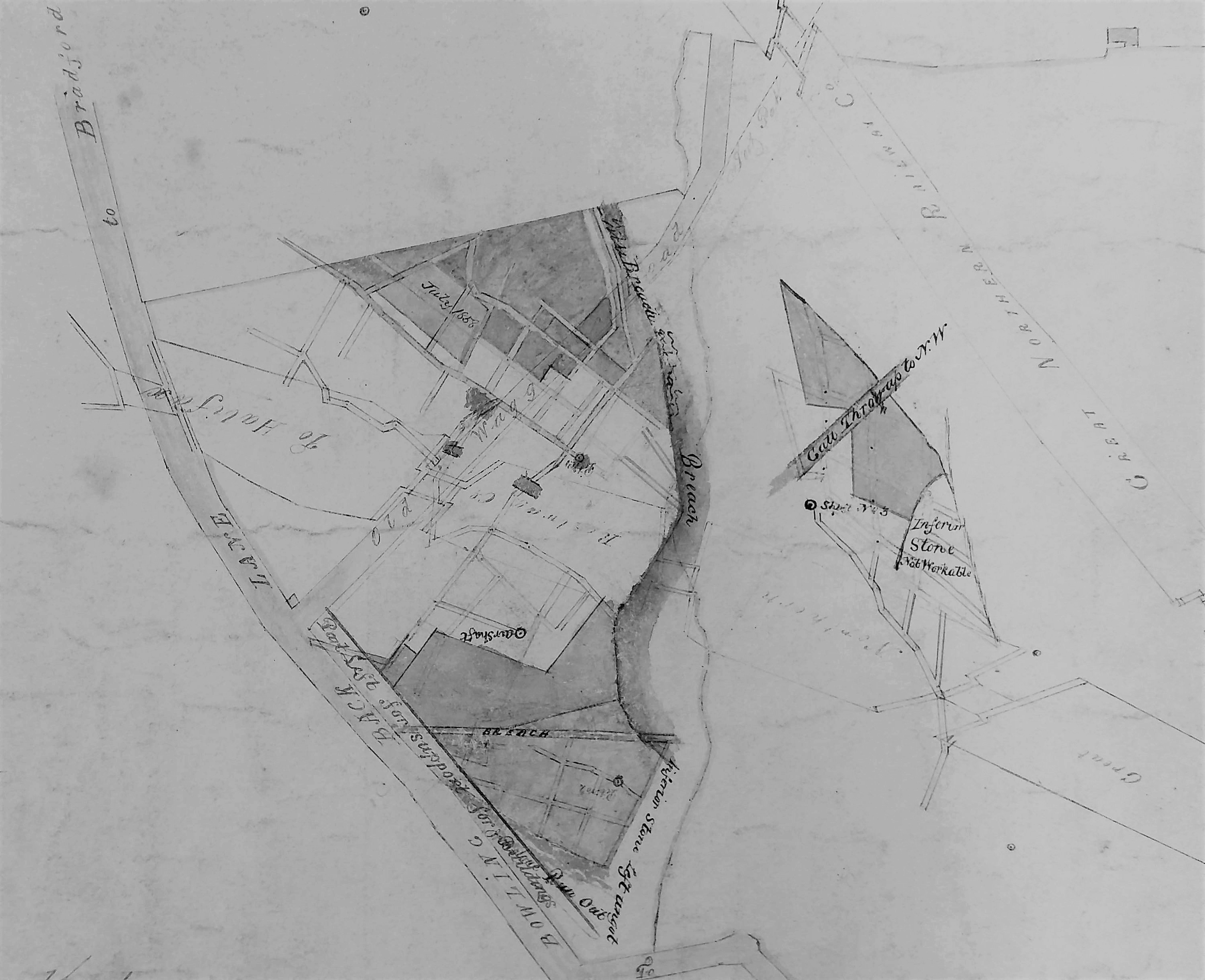
The first two plans preserve a microcosm of industrial life of the mid-nineteenth century, in an area of Bradford not previously examined in this series. The Local Studies Library reserve map collection has two versions of the Field House Estate plan and I have provided a detail from each. They identify the estate as one of the many pieces of Bradford property belonging to the Rev. Godfrey Wright, who has featured more than once in these columns.

Map of the Week 026 A

A:Iron stone workings’ 1858-1860.

Map of the Week 026 B

B: Coal deposits exploited in several years between 1850-1860.

When were the plans originally drawn up? Plan B is actually dated 1847. I  assume both were created in advance of mining to record future areas of ironstone and coal extraction. Perhaps the operator, or Godfrey Wright’s agent, was responsible for them when the minerals were accessed in the decade after 1850. Two shadowy railway lines are clearly visible on both maps. The upper is marked Great Northern Railway Co. with ‘from Bradford’ on the left and ‘to Leeds’ on the right: the Adolphus Street to Leeds Central route then. The lower line is again G.N.R. and is marked ‘from Halifax’ in very poor script on the left, and again ‘to Leeds’ on the right. I am not a railway expert but I assume the second was the Bowling Junction-Laisterdyke line (opened 1854) which must have permitted Halifax-Leeds trains to bypass Bradford. Quite large portions of the line are still visible on modern aerial photographs but the rails themselves have been taken up. The two lines come together just off the plans to the right. From the date of the maps I think we can be certain that the railway information was a late addition, but in any case you can see the railway lines are drawn across the pre-existing field boundaries.

If any reader can immediately identify the correct placement of this area in modern Bradford I shall be very impressed.  It is easier if you mentally rotate the maps by 45 degrees to the left which brings north to the top centre. The road on the left of the plans, running from eleven to five, is Bowling Back Lane. In this section, when corrected oriented north to south, Leeds Road, the Bradford-Leeds railway line and Bowling Back Lane are running roughly parallel. It was probably not a very beautiful area. Cudworth describes Bowling Back Lane as: ‘pretty well cut up with railways and cinder heaps’. It is not easy to link plan features to those on the first OS map of the area which in theory would have been surveyed at about the same time, in the late 1840s. Field House and two associated gardens are represented by the cluster of rectangles in the lower centre of map B. There’s no doubt about the written name although the ‘F’ is difficult to distinguish from the long ‘s’ of house. Field House is much smaller on the OS map. Probably there was demolition when the railway line was created.

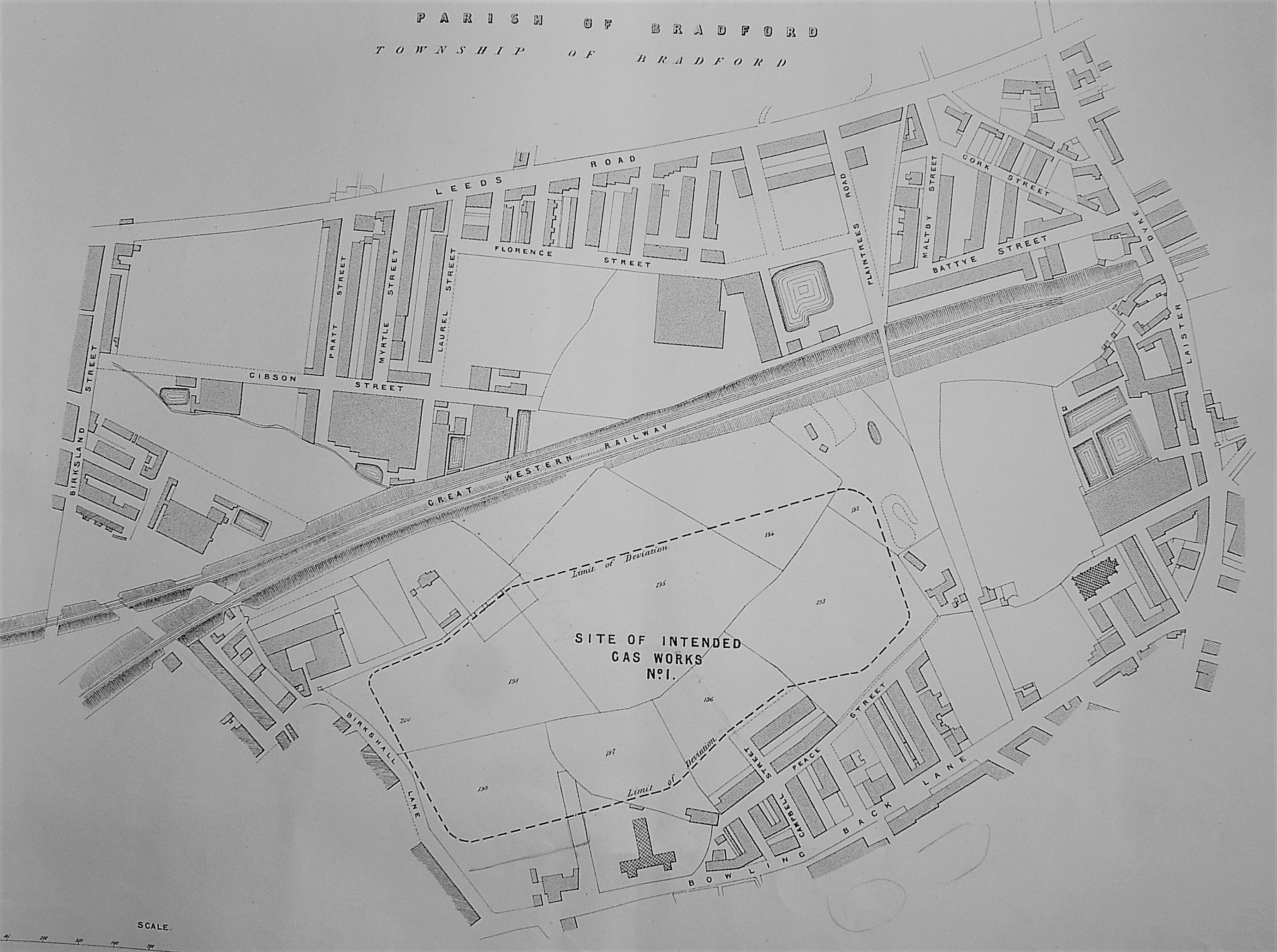
At the bottom of map B is a carriage road off Bowling Back Lane which is labelled ‘to Birks Hall’. This road is truncated on map A. Birks Hall had existed at least since the seventeenth century when it was occupied by a member of the Richardson family. Later it belonged to Benjamin Rawson, but newspapers contemporary with the maps seem to suggest that in the mid-nineteenth century it was in multiple occupancy. Notable residents were Letitia Steadman (widow of William DD, of Horton College) who died there in 1837. In 1845-46 William Murgatroyd, who was promoting railway routes, lived there. Nothing of Birks Hall appears on our two plans, nor the associated Golden Fleece Inn. The estate was sold in 1847 and ultimately became the site of a Bradford gasworks in 1877, which remained in use until the arrival of North Sea gas. Plan C was presumably surveyed just before this happened and is from a collection at  Bradford Industrial Museum. It is on a different orientation to the first two but you will see that the left edge of the more modern plan joins the right edge of plans 1 and 2 and a good deal of housing development has taken place here.

Map of the Week 026 C

C: Site of the intended Birkshall Gasworks

The older plans show a total of three tracks leaving Bowling Back Lane or the Birks Hall road and heading north. In the centre is an access way to Field House itself. If I am correct the ‘Old Wagon Road’ was a mineral tramway used by the Bowling Iron Company. In his unpublished account Derek Pickles calls it ‘Golden Lion’ and says: ‘this line was one of the earliest put down by the Company. It ran from the (Bowling Iron) Works, across Bowling Back Lane, along the line of what is now Hammerton Street to coal staithes at the rear of the Golden Lion Hotel in Leeds Road.’  It is clear from the OS map that arches had been created on the railway embankments to allow the tramway to pass beneath them. The third track, Pit Road, as a name which is fairly common in mining areas. This one ran to New Leeds, the name applied to the development immediately south of Leeds Road. Today Birkshall Street and Hammerton Street are in approximately the position of these three tracks.

To examine the two extraction industries shown it is easiest to start on the right of the first two maps with a diamond shaped area. This is evidently underground and is accessed by shafts and galleries. Across it runs a ‘gall’ or throw, that is a geological fault. An area of unworkable material is labelled as coal in one map and stone in the other. Stone must mean ‘ironstone’ although the more common sandstone was mined, as well as quarried, in some parts of Bradford. To the left of this diamond is a much larger, roughly triangular, area of exploitation crossed by a long ‘breach’. I have seen this word before in local mine maps and I assume it represents a larger fault. Plan A shows ironstone working and plan B a much larger area for coal mining. The combination of iron  ore and coal would suggest that the famous Black Bed coal seam was being accessed but a note elsewhere on Plan B helpfully identifies ‘blackbed workings’. Modern borehole reports, from reasonably near the site, suggest that the seam is 20-30m deep. The mined products were surely sent to the premises of the Bowling Iron Company just to the south.

The mining is shown to be extensive, but not unrestricted. In the pillar and stall technique miners left columns of coal to support the gallery roof. Miners could be even more cautious. In Map A a strip along Bowling Back Lane was shown unmined ‘for support for buildings’. The fact that this is being done must indicate that the mined seam is fairly shallow. It is difficult to suggest a date for the conclusion of mining in this area. For one thing I cannot identify the colliery’s name. The first OS map shows a Birks Hall Colliery south of the track to Birks Hall itself, but this is seemingly not part the Field House Estate. Field House does not appear to show any mining activity at all on the first OS map although the 1850 Bradford map shows some ‘old pits’. One explanation would be that the activity on this ground began soon after the OS surveyors had left. The Godfrey Wright died in 1862 and it is possible than the plans were completed because of this event. Wright would never have operated the mines personally, but who did? The Jones Mercantile Directory of the following year lists over 100 coal proprietors and merchants in Bradford which indicates the extent of the industry. In the 1851 census two families live at Field House. The head of one is Abraham Rodgers, 65,  coal dealer employing 30 men. Could he be the colliery operator? I have tried to find out more about him. If he also spelled his name Abm Rogers I can also locate him 10 years later in Wortley when he is a ‘coal miner and proprietor’. Sadly he doesn’t seem to feature in any of the Trade Directories I have consulted which is an unsatisfactory conclusion to the study of these fascinating plans.

Derek Barker, Local Studies Library volunteer


Map of the Week 25: East Bierley

I was not born in West Yorkshire which is an excuse for periodically getting lost in the urban areas south of Bradford. The most recent occasion led to my discovering a real gem, the village of East Bierley. It has an almost rural air with a village green and a well-known cricket club. It is no surprise to learn that it has been a conservation area since 1981, in recognition of ‘special architectural or historic interest’, since the village has a substantial number of lovely eighteenth and early-nineteenth century stone built properties. Admittedly East Bierley is ‘over the border’ in Kirklees but in the past it had significant coal and wool links with Bradford, and the Local Studies Library reserve map collection has a very detailed plan of the village recording both the names of fields and land-owners.

Map of the Week 025 A

A plan of East Bierley and the surrounding fields. The absence of the railway line and paucity of coal mining activity may date it to the late 1830s.

I’ve included a view of almost the entire plan and also a detail showing the village centre which should be clearer. The plan is extensively annotated in both pen and pencil. It was clearly a working copy of some type, possibly a land agent’s plan. The pattern of fields and buildings in this plan very closely resembles the first Ordnance Survey map of the area which was surveyed in 1847. So my first thought was that our plan might also represents the situation in the late 1840s. It could pre-date the OS map since it does not include the Great Northern Railway line section from Birkenshaw & Tong to Dudley Hill stations. This raises an interesting and slightly mysterious point. There is an extremely helpful website which records the lost railways of West Yorkshire:

http://www.lostrailwayswestyorkshire.co.uk/

The expert enthusiasts managing this site believe that this section of track, part of a Gildersome to Laisterdyke line, was opened in 1856 which makes its appearance on an 1852 OS map edition surprising. Possibly revised sheets of the first OS map were issued to allow for such major developments.

Map of the Week 025 B

A detail showing East Bierley properties, some of the land-owners and ‘Bell Pit Hills’.

It would be wrong to assume that the annotations are necessarily contemporary with the plan but there are some indications that this is the case. Not all the land-owners’ names are legible but I can recognise: Joseph Waterhouse, Joseph Speight, William Booth, Joseph Binns, John Woodcock, John Firth and James Verity. I have tried to identify some of these individuals in trade directories and the censuses for 1841 and 1851. It seems that East Bierley is linked to Hunsworth for recording purposes. The 1851 census indicated that by the mid-nineteenth century coal or ironstone miner was the commonest occupation in the village, and there was even a single 11 year old ‘pit boy’. The second commonest occupation was wool-comber, this being an essential part of the worsted process. Nearby Birkenshaw Mill and Wilson Mill both wove worsted cloth. There were residents employed in other textile trades such as spinners and power-loom weavers. Next in frequency were farmers and finally a grocer, a druggist, and two boot and shoe makers. Family history really deserves prolonged study, rather than the quick assessment which is all that I provide. What I can say is that Joseph Speight, William Booth, John Woodcock, John Firth and James Verity can all be identified as farmers in the 1841 census but only John Firth survives to 1851. I therefore think that it is reasonable to date the addition of the annotations to the early 1840s.

The plan maker seems to be more concerned with with the surface land ownership than the mineral resources underground. This makes it possible that the plan itself was originally drawn up as early as the 1830s before the Bowling Iron Company leased the right to mine coal in this area. Certainly by the time of the first OS map there were several working and abandoned coal mines existing within the area of the plan, also ironstone pits and a tramway taking material to Bowling Iron Works. On our plan there are just two, quite subtle, references to ‘black diamonds’. One is a ‘pit’ noted above and slightly to the left of the pinfold where stray animals were kept. The other is a field name at the top centre of the detail, in the occupation of Joseph Waterhouse. The name recorded for this is ‘Bell Pit Hills’. Bell pits are commonly encountered in accounts of early mining. In this method a short shaft was sunk down to a shallow seam and its base was then expanded as the mineral was removed, creating a bell-like profile. When unsafe, because of potential roof collapse, the bell was abandoned and a new shaft sunk nearby. Each bell was filled in turn by waste dug out of its successor. Since the exact situation underground cannot be determined from surface remains ‘shallow shaft mining’ is now the preferred term.

Map of the Week 025 C

A detail of the plan included in Derek Pickles’s unpublished work showing the pits and tramways near East Bierley at their maximum extent. The triangles are pits which, in many cases, are numbered since their names are unknown.

In his very detailed study of mineral tramways, curated by Bradford Industrial Museum, Derek Pickles recorded that ‘in 1839 the (Bowling Iron) Company leased 1200 acres of land in Toftshaw and Hunsworth from the Earl of Scarborough, and began to work pits in the area’. The Earl was at that time Lord of the Manor. It is possible then that the original plan pre-dates this event. The shallowest seam in the East Bierley area was called the Blocking Bed (or Toftshaw Bed) Coal. At nearby Toftshaw Colliery, which was open  between 1913-1950, the Blocking Bed Coal was found at 26.5m and the deeper Shertcliffe Coal seam at 87m depth. Other bore hole reports available from the British Geological Survey suggest that more usually Shertcliffe Coal was at 30m depth in this area, and was widely exploited. The fact that there were also ironstone miners and ironstone pits in East Bierley suggests that the ironstone containing Black Bed Coal seam was also being accessed about 67m below the Shertcliffe Coal. Derek Pickles recorded that the Bowling Iron Company already had shafts of 95m depth to reach the Better Bed coal but when it ‘extended its operations into Hunsworth, Toftshaw and Tong much larger and deeper pits were sunk’. The enterprise was not without risk: at one of the company’s pits in 1847 the Bradford Observer reports a firedamp (methane) explosion with one miner killed and several others burned.

Otherwise peaceful East Bierley does not seemed to have occupied contemporary newspapers over much around the time of the plan. In 1838 the community contributed delegates, and a flag, to a Chartist meeting on Hartshead Moor which was addressed by Peter Bussey and Feargus O’Connor. In 1842 James Verity, one of the landowners, together with James Binns, were sworn in as constables. The following year a Bradford branch of the Leeds to Manchester railway was being considered and in 1844, at the Lister’s Arms in Manchester Road, William Patchett won a main prize at a flower show with a dark-laced pink called ‘Lady Milner’. In 1856 John Willey, representing Hunsworth, was elected a Poor Law Guardian of the North Bierley Union. He lived at Moor House, East Bierley which you should be able to make out on the right of the larger plan. His son was Francis Willey (1st Baron Barnby) a very successful international Bradford wool merchant in the late nineteenth century.


Derek Barker, Local Studies Library volunteer

Map of the Week: Bradford in the mid-nineteenth century

For this article I have drawn on details from two maps in the Local Studies Library reserve collection. Often I have to estimate the dates of plans and maps so it is a relief to have this information provided for once. Both maps have Bradford’s railway connection from the north-west at their heart.

The first is described as ‘Regina v The Midland. Railway Company, plaintiff’s plan, showing Commercial Street previous to 1849’. The second is entitled as a ‘plan of part of the Borough of Bradford showing the Midland Railway Station and Approaches, 1863’.  The maps can be reasonably regarded as showing the situation at the time of the 1851 and 1861 censuses. An even better match for the second map is the Jones Mercantile Bradford Directory 1863, made available on line by the Bradford Family History Society:

http://www.bradfordfhs.org.uk/files/Trade%20Directories/JMDB1863.pdf

In 1847, just before the date of the older map, Bradford had become a Borough.  In the mid-nineteenth century the skeleton of the modern city was in the process of erection.  Bradford Infirmary had been  built on its Westgate site in 1844. The building has been long demolished but Infirmary Field survives as a green space. In the 1850s St George’s Hall, Peel Park, and Sir Titus Salt’s Saltaire were all created. The first work on Little Germany was being done in the 1860s, as the second map was being surveyed, but would continue for several decades.

The Bradford canal had opened much earlier in 1774 and ended at a canal basin and a large warehouse. These locations show well on the earlier map. Nearby, at the end of Well Street, is a large coal staithe. This had been present for many years and also features in a map of c.1825 where it is identified as ‘J.J. & Co’. Sadly I cannot identify the owner. The movement of coal was an important consideration in the minds of the original canal promoters, but water transport of goods was in large part superseded by the railway. The Leeds-Bradford Railway, in which George Hudson ‘the Railway King’ was closely involved, arrived via Shipley in 1846. The route to Keighley was created the following year. To construct the line’s terminus Dunkirk Street was razed to the ground and on 5 March 1846 the Bradford Observer noted the ‘deserted and desolate’ street. Two years earlier a famous resident had died there at the age of 46 years. This was Reuben Holder who was noted, as the same newspaper observed, for ‘eccentric rhymes with which….he was wont to create lights and shadows for the monotonous occupations of brick maker and bill sticker.’

Our map showing the situation in 1849 describes the building as ‘Leeds & Bradford Railway Station now called Midland Station’ which strongly suggests that the great Midland Railway Company acquired the line soon after that year. The 1850 Bradford directory still uses the Leeds-Bradford name and gives the address as ‘bottom of Kirkgate’. Its superintendent is Mr M Crabtree. The map would seem to have been drawn up for litigation purposes but what the action actually involved I cannot establish. The whole district between the station and Cheapside seems to have been known as Bermondsey in 1849 and this appellation survives as a road in 1863. Is the name Bermondsey ever used today?

On the left of the 1863 map you can see Trafalgar Street with its well-known brewery. The Trafalgar Steam Brewery had been founded in the 1850s and in this period was associated with the name of Cllr. Charles Waller. The company regularly advertised its porter, mild, and bitter beers in the pages of local newspapers. It survived until the 1930s, but I’m really not sure what they did with the steam. Manor Row had been constructed in 1820. The map of 1863 clearly shows the place where Manor Row and North Parade divide. On this spot one of Bradford’s most iconic buildings, the Yorkshire Penny Bank (1895), was eventually constructed, the architect being James Ledingham. Opposite this junction was the Bradford Grammar School with School (or Grammar School) Street.  John Richards was its headmaster in the 1850s. I believe the the history of the school stretches back into the Tudor period but the building in North Parade or Manor Row was constructed in 1820. There is known to have been an earlier school building near the cathedral.  BGS has occupied its Keighley Road site, once the centre of the Clockhouse estate, since shortly after the Second World War.

Salem Street, with its listed early nineteenth century terraced houses, was presumably named after the nearby Congregationalist Chapel. ‘Salem’ is a shortened form of Jerusalem and was a popular name for non-Conformist places of worship. This classical revival building was constructed in 1835-6 using ashlar sandstone. It was one of the earliest designs of the Lockwood & Mawson architectural partnership who later moved on to St George’s Hall and Saltaire.  I have included William Mawson’s portrait from his obelisk at Undercliffe cemetery.

Map of the Week 024 C

William Cudworth records that Salem’s minister during the mid-19th century was Rev J C Miall. A new chapel was opened in Oak Lane in 1888 after which the Manor Row building was reused as school board offices, and a school clinic for many years. It still exists as Kenburgh House. While considering churches the 1863 map shows Christ Church in Darley Street which was built as a chapel of ease for the Parish Church and consecrated in 1815. It was close to Bradford market but I believe that the site was eventually needed for a Darley Street extension. The building was demolished in 1879 and Rawson Square exists at its former site. The church was moved to nearby Eldon Place where it survived until 1940.

My limitations concerning Bradford theatre history have been exposed before but there clearly was a Duke Street Theatre in 1863. On this occasion I have retrieved information from Arthur Lloyd’s theatre website:

http://www.arthurlloyd.co.uk/BradfordTheatresIndex.htm

In 1841 the Liver Theatre, Duke Street, probably became Bradford’s first purpose built theatre. In 1844 it was remodelled and re-opened as Theatre Royal, Duke Street. The fact that it was widely known as the ‘wooden box’ may say something about its construction. In 1864 the Alexandra Theatre had opened in Manningham Lane. Five years later, when the Duke Street Theatre Royal finally fell victim to another series of Bradford street improvements, the Alexandra took over the discarded name.

If from Duke Street you continued down Piccadilly and across Kirkgate you would be walking down Piece Hall Yard. According to the City Heritage blue plaque the Bradford Piece Hall had been constructed in 1773. The development of a building for trading in ‘pieces’ of cloth had been proposed by the hugely influential Quaker merchant John Hustler who died in 1790. I’m not sure when the Piece Hall was demolished, in the late 1850s perhaps. Piece Hall Yard has been, since 1877, the location of the Bradford Club. Today the Club holds an importance for Bradford studies second only to the Local Studies Library itself, since it generously allows the Bradford Historical & Antiquarian Society and the Bradford U3A to hold their meetings within its gracious portals. John Hustler’s name survives in Hustlergate. In the newer map this is recorded as the site of the Old Market but the Gothic revival Wool Exchange, which survives largely as Waterstones, was built here a few years later, between 1864-67. It was another design of Lockwood & Mawson. The foundation stone laid by Lord Palmerston, and some magnificent glazed ceramic tiles, can still be seen in the Market Street pizza restaurant.


Naturally there is a great deal of history locked up in street names. Hustlergate has already been mentioned and Market Street must reflect the old market. But look at the streets at the top right of the second map. A water source is the obvious explanation for Well Street. The older map indicates that Collier Street (or Gate) was named for its closeness to the coal staithe. The Swaines and the Booths were wealthy local families and Charles St, Booth St, and Swaine St probably all derived their names from Charles Swaine Booth Sharp (1734-1805) who owned land in the area of Hall Ings and married Hannah Gilpin Sharp, who had inherited Abraham Sharp’s Horton estate via his niece Faith Sawrey. The name Brook St must reflect the course of the Bradford Beck. This is seemingly on the surface before 1849, but the 1851 and 1861 Bradford maps suggest that it was by then culverted and underground at this point. Only the names Well St and Market St have survived to the present day.

Derek Barker, Local Studies Library Volunteer