Neglected Bradford Industries: Brick-making

Bradford is famous for spinning and weaving but textile production was only one of a group of important industries which ‘Worstedopolis’ supported. Since several  are now almost forgotten by contemporary citizens I should like to draw attention to those which seem unreasonably neglected, in a series of short articles.

Together bricks, tiles and terracotta form the ‘ceramic building materials’. This technology was introduced into Britain twice; firstly by the Romans and secondly from the Low Countries in the Middle Ages. The ruined Augustinian priory of St Botolph, Colchester (1100-1150) is a Norman building built of flint rubble and recycled Roman brick. Brick use was insignificant until the fifteenth or early sixteenth centuries when magnificent work appeared at Tattersall Castle, Lincs (1440-1450), Framlingham Castle, Suffolk (soon after 1476), and Hampton Court (1515). The first West Yorkshire brick building is believed to be Temple Newsam House, Leeds (1640-60s). The earliest Bradford brick-maker I have been told about features in the Eccleshill parish records of 1714. Later, in 1718, John Stanhope of Eccleshill wanted to build a new hall and so reached an agreement with John Brown of Nottingham who promised to ‘dig and throw sufficient clay to make 100,000 good stock bricks’. The bricks were large by modern standards, being 10 inches long, 5 inches broad, and 2.5 inches thick when burned.

Hand-moulded bricks were formed by a maker throwing a clay and water mix, of the correct plasticity, into a wooden mould. A skilled maker with a lad could produce a thousand or more bricks daily. Newly moulded green bricks were dried slowly in a hack, or shelter, and could then be successfully fired in a free-standing heap or clamp. Constructing a true kiln needed more expenditure but the firing was more controllable, resulting in a better product and fewer waste bricks. Hand-made bricks survived the spread of the latter mechanical brick presses since their manufacture required little capital. Such bricks are still available today for conservation projects.
05 Image A

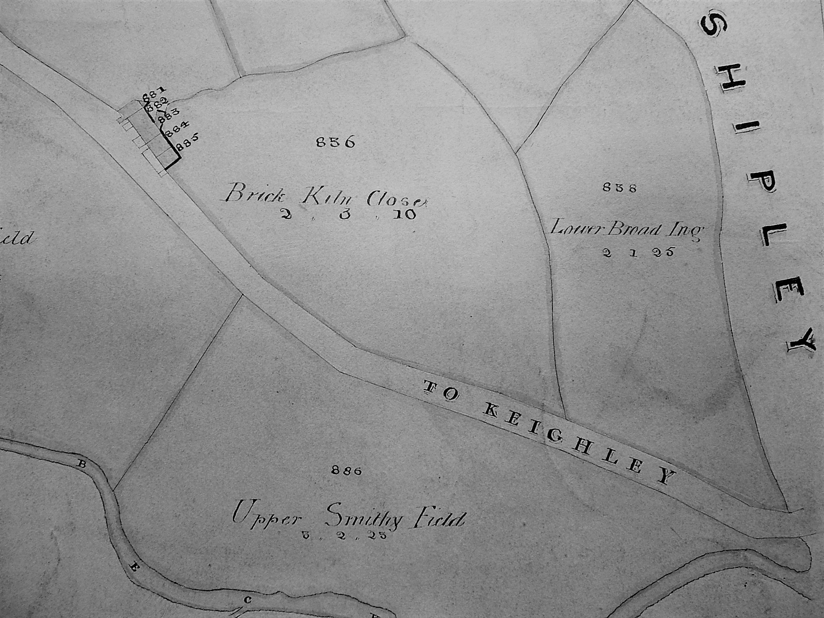
Brick-kiln close, Frizinghall. Field names with brick related elements, or buildings known as Red Hall or House, are common indicators of early brick production and use.

Local historian Tony Woods has studied the Rosse Archive records now in Ireland. He can demonstrate that Heaton coal pits were supplying a brick kiln as long ago as 1776. The field name recorded on the above map from the Local Studies Library collection confirms that there was one such kiln quite close to Heaton village, but there may have been others.  A study of early Bradford maps suggests that brick fields preceded established brick works. Evidence from elsewhere suggests that the alluvial clay in such fields was leased by owners to itinerant brick-makers who dug it and prepared it for firing into hand-moulded unmarked, or plain, bricks. There is evidence that there were such undertakings at: Fagley Lane, Bowling Back Lane, Low Moor, Frizinghall, Manningham, Leeds Road, Manchester Road, Bolton, Undercliffe, Shipley, Eccleshill and Wilsden.
05 Image B

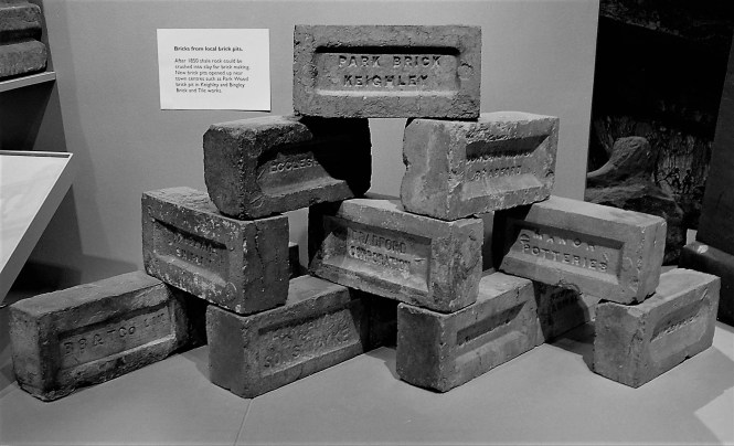
Machine pressed bricks on display at Cliffe Castle Museum, Keighley. Note the [BB&T Co Lim] marked brick at the bottom left.

By the mid-nineteenth century engineers were experimenting with ways of forming bricks mechanically. Common household bricks produced by machine pressing started to appear after 1860, and by the last decades of the century mechanical presses came to dominate production. There were small hand-operated brick presses and large steam powered machines of various patterns. Their use avoided the need to employ skilled brick-makers at a time when the demand for bricks was rapidly increasing. The new machines also produced a uniform product much loved by Victorian architects. In the Bradford area mudstones from the Coal Measures were quarried or mined, and then ground up, to supply the brick presses. The coal seams themselves provided the fuel for firing the bricks. Machine pressed bricks frequently have a depression, or frog, for receiving mortar and may be marked with the manufacturer’s name or initials. Such marks could be stamped into the brick but alternatively brass or iron plates were inserted into the brick moulds. The heads of screws that held these plates in place may also be visible in the fired brick. The interest of those of us involved with bricks was often first captured by finding a marked brick and speculating about its origin.
05 Image C

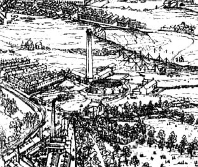
A detail from the drawing accompanying William Cudworth’s Worstedopolis. In the centre is the Hoffman kiln at Daniel Riddiough’s Airedale Road brick works.

New patterns of kiln were adopted. Circular Beehive kilns were popular for single firings. Circular or oval Hoffman kilns were kept continuously alight. Kiln gases, on their way to the chimney, were used to dry green bricks. Hoffman kilns were very economical of fuel but needed a skilled workforce. The Bradford 1856 directory records several local manufacturers: James Fairbank, an important coal merchant and brick maker, was established at the Brick Lane colliery and was ‘sinking for coal’ near the bottom of Whetley Lane. Edward Gittins had arrived from Leicester and was advertising his new patent-brick works at the junction of Wakefield Road and New Hey Road. George Stelling Hogg had come from Leeds and had established the first of his three brick making enterprises in Shipley. George Heaton had leased land from the Earl of Rosse to dig coal and make bricks at the Shipley end of Heaton Woods. As late as the 1881 census  I can only identify 204 people in the Bradford area who gave a brick related occupation to the enumerators. This number is dwarfed by coal and ironstone miners, quarrymen, and textile workers.

Research suggests that at one time or another Bradford, Shipley, Bingley and Keighley had more than 60 brick production centres, not of course all working simultaneously, together with additional imports from Halifax, Leeds and Wakefield. At first bricks were used close to the site of manufacture to minimise transport costs. Consequently the few wholly brick houses in Bradford older than a century are likely to be constructed of locally made material. Most readers will be familiar with Bradford’s stone buildings and will naturally ask the question ‘where have all the bricks gone?’  Flues from domestic fires were normally constructed of them, and many Victorian stone buildings will have an inner skin of cheaper brick with stone facings on the visible areas. When you consider the use of bricks employed for Lancashire pattern factory chimneys, or for railway bridge or tunnel linings, the number of producers does not seem excessive. In the long run the railway spelled the end for local suppliers in favour of larger, cheaper, brick producers in Peterborough or Staffordshire.

05 Image D

Trade directories are a useful source of information about the brick industry. Advertisements were common.

A popular local house-brick was produced by the Bradford Brick & Tile Company and its most common mark is [BB&T Co Lim].  This company was incorporated in January 1868. The first directors were Halifax businessmen, with the exception of Israel Thornton of East Parade, Bradford (a contractor with his fingers in many pies). At various times it operated a number of kilns: Wapping Road, Whetley Lane and Beldon Rd, Great Horton. By 1901 the Bradford Brick and Tile Company address was simply Knowsley Street, Leeds Road which seems to have been its final enterprise.

If you want to explore brick-making further I would suggest:

D J Barker, Bradford Brick-making: the mud, the men and the mysteries, Bradford Antiquary, (2010) 3rd series 14, 66-77.

The West Yorkshire Archives (Bradford) have more information on the Bradford Brick & Tile Company (10D76/3/113 Box 5). The Local Studies Library collection of trade directories are also an important source of information.

Derek Barker, Local Studies Library Volunteer
 

Treasure of the Week no. 18: Galas & Fents in Peel Park

JND 194/8 (Please quote this number if requesting this item)

jnd 194 8 c 001

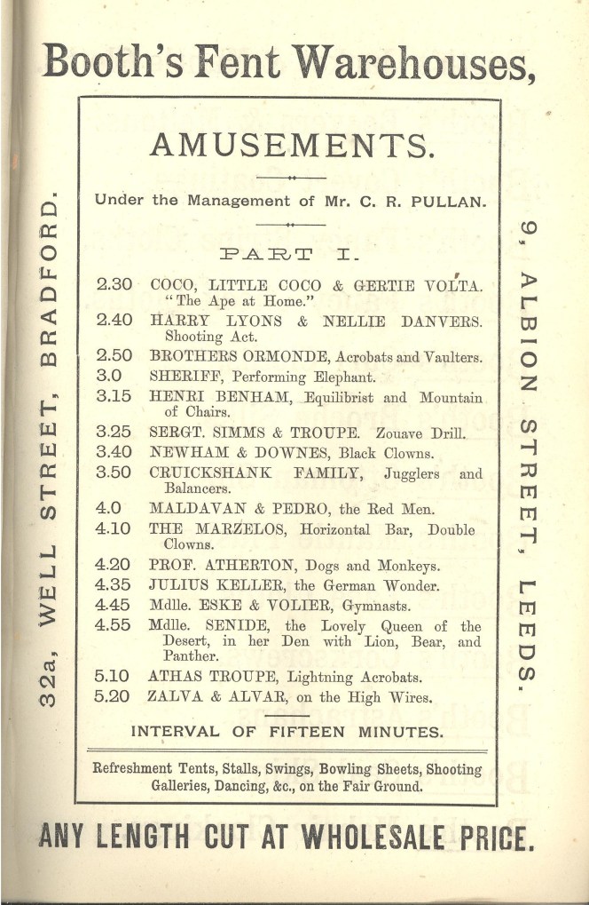
BOOTH’S FENT WAREHOUSESProgramme for the Annual West Riding Galas held in Peel Park, Bradford, Whisuntide, 1888.

Galas and Melas have been held in Peel Park for many years, but what went on in these festivals has changed greatly. In 1888 the Gala lasted two days and in the Library’s pamphlet collection we have the 16-page programme of events  sponsored by Booth’s Fent Warehouses. Fents were basically animal skins and Booth’s, whose main shops were in Well Street, Bradford and Albion Street, Leeds, made sure that people who purchased the programme for one penny could not escape knowing about their products. There were full page adverts for Booth’s Umbrellas, Booth’s Scotch Tweed, Booth’s Cheviots, Booth’s Doeskins, Booth’s Meltons, Booth’s Beaver, Booth’s Italians, Booth’s Silesias, and much else. Products long forgotten.

So much for fents. What went on at Peel Park in the spring of 1888? A lot! Amusements included:

Coco, Little Coco & Gertie Volta  – ‘The Ape at Home’

Harry Lyons & Nellie Danvers – Shooting Act

Brothers Ormonde – Acrobats and Vaulters

Sheriff – Performing Elephant

Henri Benham – Equilibrist and Mountain of Chairs

Sgt. Simms & Troup – Zouave Drill

Newham & Downes – Black Clowns

Cruikshank Family – Jugglers and Balances

Maldavan & Pedro – The Red Men

The Marzelos – Horizontal Bat, Double Clowns

Prof. Atherton – Dogs and Monkeys

Julius Keller – The German Waiter

Mademoiselle Eske & Volier – Gymnasts

Mademoiselle Senide – The Lovely Queen of the Desert, in her Den with Lion, Bear, and Panther

Zalva & Alvar – On the High Wires

There were fireworks by Professor Wells, whose displays included The Wheel of Ixion and the Revolving Fountain. There was Professor Smith with his Famous Punch & Judy Show Performing at Intervals; There was a full music programme – Six military bands, including the  2nd West York Artillery and local orchestras such as the Postmen’s Band, the Manningham Band, and the Bradford Borough Band played a wide repertoire of music.

About eight o’ clock each night, weather permitting, inventor Eric Stuart Bruce, was to personally supervise the ascent of ‘The Electrical War Balloon! For Flashing Signals at Night, As Supplied to the English and Belgian Governments’.

And, of course, there were Refreshment Tents, Stalls, Swings, Bowling Tents, Shooting Galleries, Dancing, &c., on the Fair Ground.

Imagination is required to understand what some of these activities were about. Performing animals, black clowns, and Punch & Judy would now be frowned on, but I can’t help wishing I was there, at Peel Park, in 1888, watching Zalva & Alvar on the high wires, and the Fireworks, listening to the Bands, visiting the Refreshment Tents, and waiting impatiently for the ascent of the flashing signals from The Electrical War Balloon!

Stackmole

Map of the Week 027: What was going on in Great Horton?

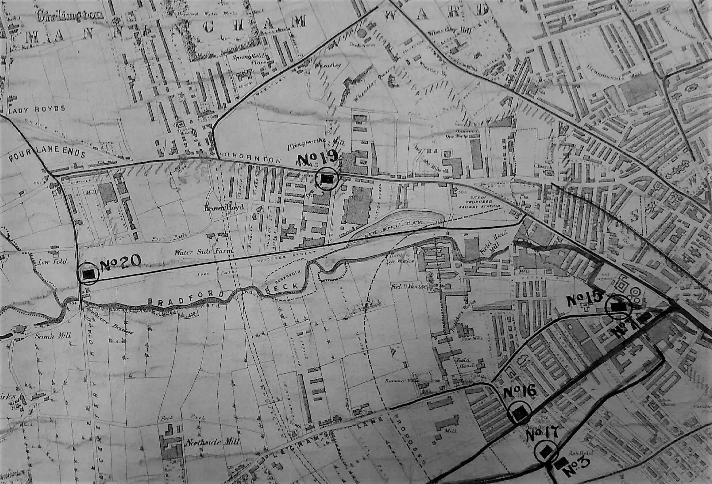
If you are reading this article you probably find maps and plans as interesting as I do. You will certainly understand how easy it is to get distracted, while writing a brief report, by trying to identify all the recorded features and resolve some of the inevitable puzzles. The first image is a detail of a map in the reserve collection which is in poor condition. The parent map is the one produced of the Borough of Bradford in 1873 by Walker & Virr, which is especially valuable since it falls evenly between the two first Ordnance Survey maps of the 1850s and 1890s. The twenty years that preceeded the Walker & Virr map brought huge changes to Horton. In 1850 the community had been surrounded by many coal and ironstone pits, both functioning and disused. Tramways conveyed their products to the Low Moor Ironworks for conversion into best Yorkshire wrought iron. By the 1870s the seams were exhausted, the pits were closed, and there had been considerable housing development.

Map of the Week 027 A

A map detail showing Great Horton watercourses and main sewers

This map was in a group that evidently came to the Local Studies Library from the city’s Surveyors and Engineers Department. Its purpose is clearly recorded, this being to record Bradford’s main sewerage system and to show storm overflows. The main sewers collected both foul water and surface water. During a rainstorm they could become completely filled. Under those circumstances the plan was for the excess to flow into alternative sewers and ultimately watercourses like the Bradford Beck; not a pretty thought. The positions of the storm overflows are more easily displayed in a second map detail.

Map of the Week 027 B

A detail from the same map showing sewers in the area between Thornton Road and Legrams Lane

The Borough Surveyor (B.Walker) employed this map. It was clearly being used for at least a decade after its first publication since pencil annotations are dated for the years 1881-83. Having dated the map and identified its use I thought that there were three features of particular interest: the Old Mill, Bracken Hall, and the brick works.

The longer watercourse in the first image is the Horton Beck which provided the water for the Old Mill. A little further down stream, out of sight, was a second corn mill called the New Mill. I assume that the Old Mill started life as a manorial watermill, like Bowling Mill or the Bradford Soke Mill. William Cudworth records that in the nineteenth century the Lord of the Manor of Horton was Sir Watts Horton and then, after his death, his son in law Captain Charles Horton Rhyss. His property came up for sale in 1858 when William Cousen of Cross Lane Mill purchased the lordship. The Old Mill, its farm, and the water rights went to Samuel Dracup a noted textile engineer. He, it appears, eventually converted Old Mill to be a textile mill. I am more interested in an earlier tenant of Old Mill recorded in the Ibbetson’s 1845 Bradford directory, John Beanland. He was the son of Joseph Beanland who was a corn miller and colliery proprietor at Beanland’s Collieries, Fairweather Green. Cudworth says he belonged to a Heaton family. There was certainly a James Beanland (1768-1852), of Firth Carr, Heaton who exploited coal in Frizinghall.

Cudworth describes the impressive looking Bracken Hall as being of a fairly recent origin. I’m sure Cudworth is correct since the Hall is not present on the 1852 OS map of the area. It was inhabited by William Ramsden who was the owner, with his brother John, of Cliffe Mill. This was a Horton worsted mill which can be seen in the centre left of the first map. Bracken Hall was described as being ‘surrounded by a thriving plantation’ which is certainly the appearance that this map records. In the 1881 census William Bracken (54) and his wife Sarah (57) were living at the Hall rather modestly, with only a cook and a housemaid. I am not sure when the house was demolished. It certainly survived into the twentieth century but is missing from the 1930s OS maps. Before the construction of the Hall there were fields and a pre-existing farmhouse which I assume is the small building called Bracken Hill on the OS 1852 map. The land was owned by Mrs Ann Giles who possessed much property in Great Horton including Haycliffe Hill and Southfield Lane with the fields in between. The means by which she acquired her estate was quite complicated. Hannah Gilpin Sharp (1743-1823) of Horton Hall bequeathed her mansion, with all her land in Bradford, to her nephew, Captain Thomas Gilpin and his male heirs, and in ‘default of issue’ to her niece Ann Kitchen. Captain Gilpin, after enjoying the estates for only three years, died at Madeira in the year 1826 without ever having been married. So Ann Kitchen came into the property. In 1828 she married a clerk in Somerset House, as her second husband. Cudworth records him as Edward Giles, but I believe that Edmund is the correct name and the couple were united at St Pancras Old Church. Here their son, another Edmund, was baptised the following year. Ann Giles lived in Tavistock Place but her husband died in 1832 leaving his infant son as heir to the Horton estates. At the age of 25 this son Edmund eventually went to Australia, being enamoured of sea life, but only lived three days after landing in the colony. In 1839 an Act had been passed for disposing of the Giles estate at Horton, owing to the great increase of buildings in the immediate vicinity. Land belonging to ‘Mrs Giles’ are common on maps of Bradford and Horton. In the 1851 census she and Edmund were staying with her daughter by her first marriage, Ann Haines, who was ultimately to inherit her estate.

It seems that I may have fallen at the final hurdle since I cannot identify the owner of the brickworks. In the 1880s Great Horton had no less than three brickworks: Beldon Road, Haycliffe Road and this mapped works in the High Street. The Beldon Road works was owned by the Bradford Brick & Tile Company in the years 1875-1927. The Haycliffe Road works were linked in 1871 with an E.Hopkinson (Wm. Holdsworth manager) and in the years 1875-1883 William Holdsworth seems to be the owner himself. The High Street brick-works was the earliest but its existence may have been brief since it is attested only by maps of 1873 and 1882. It does not feature in the libraries’s stock of Trade Directories. One possibility is that it belonged to Robert Bown ‘coal merchant and brickmaker’ whose bankrupcy was reported in the Bradford Observer in March 1864. Twenty thousand bricks from the ‘Horton yard’ were to be auctioned. A coal merchant of that name lived in Little Horton in the 1861 census. Even if this is true who kept the building going for at least another ten years?

If you would like to learn more about historic Horton I can recommend:

www.bradford.gov.uk/media/2373/greathortonconservationareaassessment.pdf

Derek Barker, Local Studies Library Volunteer.

Missing Priest

Bradford Local Studies Library recently assisted researchers in a radio programme which was aired on Radio 4 recently.

Bradford’s Polish Roman Catholic Community became nationally famous in the summer of 1953 when its parish priest, Father Henryk Borynski, disappeared.

One afternoon in July 1953 Father Borynski took a telephone call. His housekeeper heard him say ‘OK, I’ll go’. He put on his hat and his coat and left. He was never seen again.

Many Poles fled to the UK during World War II and settled in Bradford. With the onset of the Cold War they became exiles, unable to return to Poland. Father Borynski was an outspoken critic of the Soviet system and many believed that he could have been a victim of communist agents operating in England.

Six years after Father Borynski walked out of his presbytery in Little Horton Lane the Church assumed him to be dead and a requiem mass was held at St Joseph’s Church where the Poles then worshipped.

The story of this unsolved mystery is investigated by Steve Punt in the programme in which he follows leads and opens Secret Service files, to find out what might have happened to Father Borynski.

There is still chance to listen to this programme: ‘Punt PI’ Series 10 ‘Missing Priest’ at the link below:

http://www.bbc.co.uk/programmes/b093hv5r

Neglected Bradford Industries: Stone Quarrying

Bradford is famous for spinning and weaving but textile production was only one of a group of important industries which ‘Worstedopolis’ supported. Since several  are now almost forgotten by contemporary citizens I should like to draw attention to those which seem unreasonably neglected in a series of short articles.

It is the extent, rather than the existence, of Bradford’s stone quarrying industry that has tended to pass out of memory. Bradford sits on a series of Carboniferous period sedimentary rocks called the Lower Coal Measures. This series contains strata of commercially valuable fine grained sandstone such as the well-known Elland Flags. Beneath the Coal Measures is the Millstone Grit series which also provided building stone. Saltaire, for example, is constructed of gritstone. There is no essential difference between these two series of rocks, no unconformity as geologists would put it, and their junction is defined by a particular fossil species. Millstone Grit outcrops to the west and north of the city, forming the scenery of Shipley Glen and Ilkley Moor. The Aire Valley glacier once carved its way deeply into the Millstone Grit making it possible for this rock also to be exploited quite near Bradford. Sandstones and gritstones are largely composed of cemented grains of the hard mineral quartz. Ultimately these grains were derived from weathering igneous rocks and transported here, and deposited, by a vast river delta more than 300 million years ago.

Although stone was principally a construction material it did have other uses, dressed gritstone was once employed for the millstones in corn mills for example. Midgeley Wood at Baildon Green is said to show evidence of this industry, and I should be grateful if any reader could confirm this. Stone could also be crushed for gravel and sand. Any stone occurring in thick beds, which can be cut freely in any direction, is called freestone. Once hewn for facing it is known as ashlar. Gritstone and ragstone are sandstones with coarse, angular, grains that cut with a ragged fracture. Flagstones are thin bedded sandstones ideal for flooring and roofing. When this material is used on a roof it is often referred to as ‘stone slate’ although it is not true slate which is a metamorphic rock. There are plenty of true slate roofs in Bradford of course but slate came by rail, after the mid-nineteenth century, from Wales or, to a lesser extent, the Lake District. The colour of sandstone reflects its iron content. Local stone was often grey when first quarried but it oxidises, on exposure to air, producing a beautiful honey colour. Old quarries are a significant landscape feature in many parts of the Bradford area, and are commonly seen in tithe maps and the first OS maps. Many were subsequently used for land fill, recreational space, or development.

04 Image A

Quarries on Idle Moor in a detail from the first OS map of the area
(surveyed in late 1840s)

In the Middle Ages stone building was confined to high status structures: castles, churches, bridges, and great houses. The only medieval stone buildings now standing in Bradford would seem to be the tower of Bolling Hall and the Cathedral. There must have been a medieval stone quarry in Bradford since the recent Sunbridge Wells development exposed several prison cells, the rear walls of which are portions of a quarry face. Medieval vernacular architecture was in timber, thatch, wattle and daub. The construction of a large timber-framed house required carpentry of a very high order so I cannot think of timber construction as a second best to masonry. After the medieval period there was a ‘great rebuilding’ in brick and stone which in northern Britain occurred quite late, from the mid-seventeenth to early eighteenth century. Was this simply fashion, or an appreciation of the damage fire could do to a wooden urban area? As with many innovations the wealthy were the first to adopt the change. Paper Hall in Bradford is an early example in the city, and East Riddlesden Hall is a seventeenth century millstone grit construction. By the time of the 1800 Bradford map no quarries are marked and the industry has evidently moved to the surrounding high ground.

Since Bradford is famous for its stone buildings it is reasonable to ask how such large quantities were obtained. In some areas, York being an excellent example, cut stone could be recycled from Roman buildings or dissolved abbeys (after the 1540s), but not here. Before the creation of quarries there must have been large quantities of surface stone available which had been originally transported by glacial ice. In an area I know well, Northcliffe Wood in Shipley, large glacial erratic millstone grit boulders are still on the surface, and there are also several large, shallow, surface depressions interpreted as sites from which suitable stone was simply levered up. Stone that was not of sufficient quality for masonry could still be used in drystone walls of which there were vast numbers. It appears that the old quarrymen believed that the presence of a fossil weakened the stone. Rocks containing fossils were not used for ashlar but tended to end up with the wall stone. On some common land, or wastes, local people may have had the right to remove (but not necessarily sell) such surface stone deposits. True quarrying is thought to have begun locally in the seventeenth century and continued until the twentieth. Small quarries would have had a single face for stone extraction; later and larger enterprises had a staggered series of faces, known as ‘bench working’.

04 Image B

A stone quarry illustrated in a detail of the drawing of Bradford which accompanied William Cudworth’s ‘Worstedopolis’ (top right)

The image shows a nineteenth century quarry. Its edge, and the simple derricks used for lifting stone, are easily visible. In the centre is a brick works, a subject to which we will soon return. Many West Yorkshire stones have locality or descriptive names. Bradford quarries accessed Rough Rock (Baildon & Shipley), Stanningley Rock (Northcliffe), Gaisby Rock (Bolton Woods & Spinkwell), and Elland Flags (Thornton, Heaton, Chellow, and Idle). Quarries or delphs could also be dug for special projects like the creation of canals or reservoir dams. There is a small quarry next to the canal at Hirst Wood, Shipley that presumably had this function. At first stone was used near to the site of extraction to minimise transport costs, so most stone houses older than about 150 years will be constructed of very local material. As transport improved there were  significant exports. Elland Flags were once widely used for paving slabs in London. Wakefield and Manchester Town Halls were constructed of stone from Spinkwell Quarry, which the architects believed would resist air pollution well. How extensive was the industry? In 1875 William Cudworth knew of 36 stone quarries in Allerton alone, and a further 17 on Rosse land in Shipley and Heaton. Heaton still has its Quarry Hill, Quarry Street and, until recently, The Delvers public house.


04 Image C

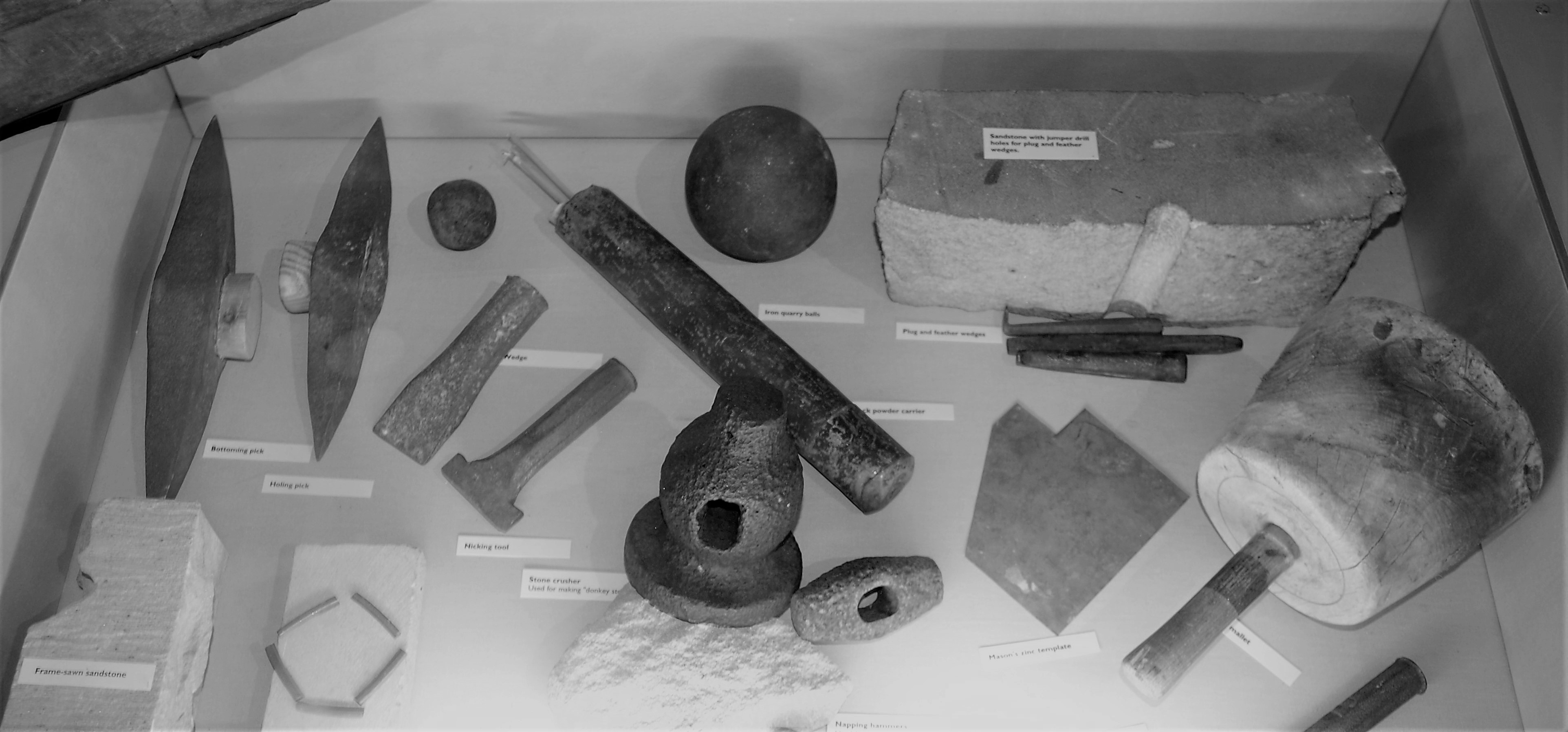
Stone-working tools from the permanent collection of
Cliffe Castle Museum, Keighley

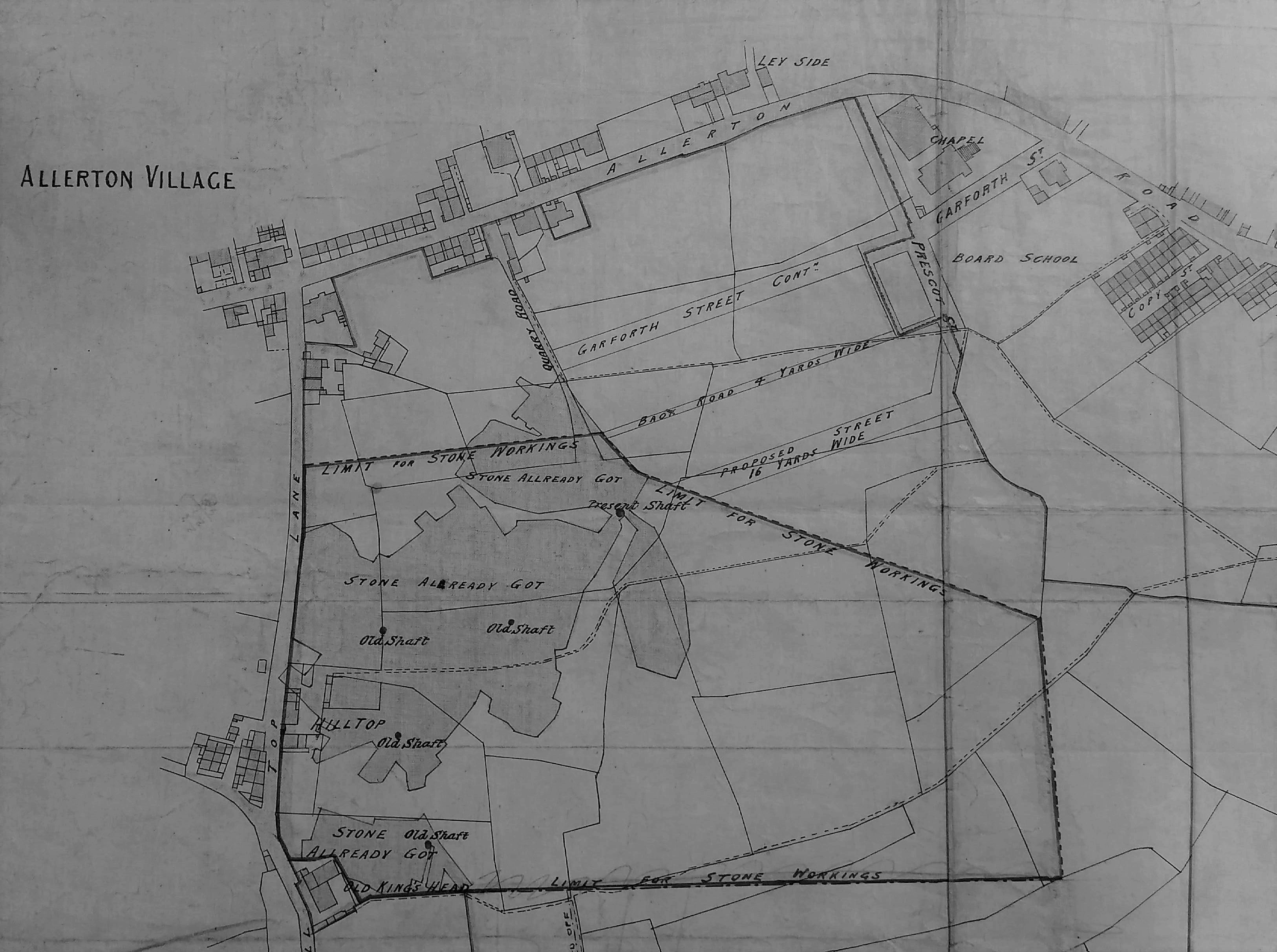
Quarry work was skilled and dangerous. Dimension stone was split away from the quarry edge with hammers, chisels and wedges. It would be roughly dressed on the quarry floor. With luck the quarry operator would equip his site with cranes or a tramway to carry the stone on to an adjacent working area. If not strong men would carry stone up a ramp on their backs, supported by two workmates, health and safety regulations being a relatively new development. Newly quarried sandstone is soft and, even before the introduction of steam power, could be cut with saws using sand as an abrasive and water as a coolant. Unusually in this area very valuable stone deposits were sometimes mined as well as quarried.

04 Image D

Plan of a stone extraction site in Allerton showing working and ‘old’ shafts

If you want to explore local industries further the gallery devoted to these at Cliffe Castle Museum is an excellent place to begin. For further reading about quarrying I would suggest:

J.V. Stephens et al., Geology of the country between Bradford and Skipton, HMSO, 1953. This is essential reading for geological background to any extractive industry.

David Johnson, Quarrying in the Yorkshire Pennines: an illustrated history, Amberley Publishing, 2016. Bradford is mentioned several times in this comprehensive, engaging, and beautifully illustrated book.

A most informative atlas of West & South Yorkshire Building Stones can be downloaded from the site of the British Geological Survey:

https://www.bgs.ac.uk/downloads/start.cfm?id=2509

Derek Barker, Local Studies Library Volunteer