Map of the Week – Coliseum Theatre

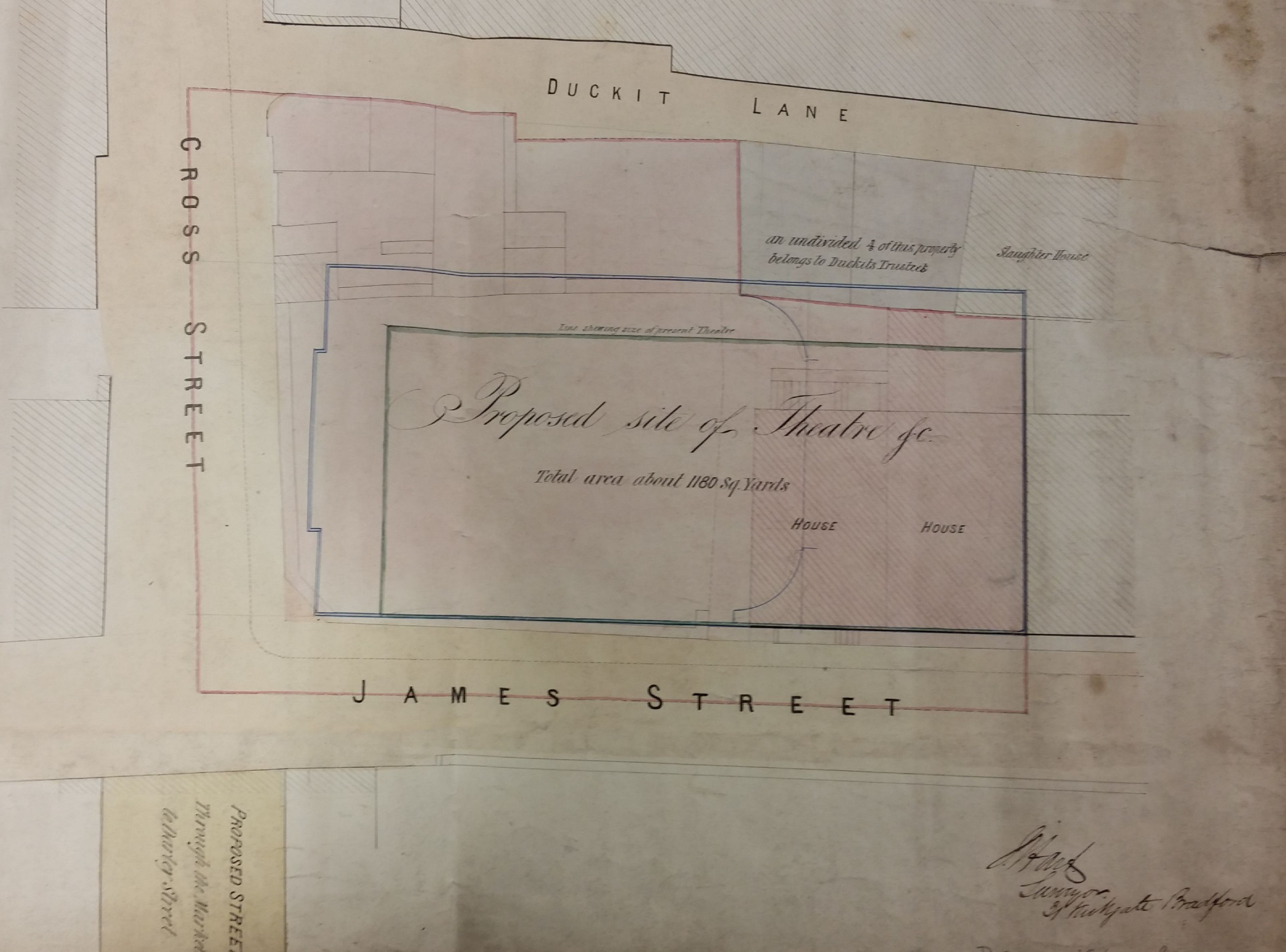
This map from the Local Studies Library reserve collection would seem to be the plan of a theatre or music hall drawn up prior to its enlargement. When I first saw it I recognised the location, between Duckett Lane and James Street, (which connect Godwin Street and John Street) but I could not see how a theatre could ever have been positioned there.  I could not then have named a single Bradford theatre besides the Alhambra and the Star Music Hall. The Star had an important role during the great Manningham Mills strike of 1890/91 when its lessee, a Mr Pullan, placed his premises at the disposal of the strike committee during the early days of the dispute. In Charles Dickens’s rather neglected novel Hard Times Mr Sleary, a circus manager, says: ‘People must be amused…they can’t be always a working, nor yet they can’t be always a learning’. So, how were they amused in Bradford? In the late eighteenth and early nineteenth centuries itinerant entertainers visited public houses, and there were also visits from fairs and circuses. It appears that permanent theatre building had commenced by the 1840s.

Map of the Week 008

The theatre in this plan was placed near Westgate and in 1849 Henry Pullan is known to have built the Coliseum Theatre ‘off Westgate’. However I cannot be sure that this map is actually of the Coliseum Theatre. Pullan had previously managed the Bermondsey Saloon in Cannon Street, a noted place of entertainment. His Coliseum was unusual in that it was not directly linked to a public house. Twenty years later he moved to a new theatre called Pullan’s ‘New’ Music Hall, Brunswick Place (now Rawson Street, by the multi-storey car park). This had an amazing 3,000 seats; the modern Alhambra has less than half that number. Pullen’s new musical hall remained in existence in the years 1869-89 at the end of which time it burned down. The vacant site left after the fire eventually evolved into John Street open market. Thomas Pullen and his son seem later to have taken over as managers of the Prince’s theatre and Star Music Hall, which brings us back to the Manningham Mills strike.

Although this plan was not dated it does mention St George’s Hall (opened 1853) and the New Exchange assembly rooms (foundation stone laid 1864), so presumably it was drawn after 1865. It seems plausible that it represented an intention to enlarge the old Coliseum theatre around 1868 although in the end a wholly new building was constructed on a nearby site. The older theatre evidently survived, being later renamed as St James’s Hall and then The Protestant Working Men’s Hall. It was finally demolished in 1892. This is a plausible date for the construction of the Commercial Inn still standing in James Street. This certainly looks like a late Victorian building.

The Coliseum was not Bradford’s first theatre which is said to have been owned by an L.S. Thompson in a converted barn on Southgate (now Sackville Street) around 1810-25. This hosted travelling theatre troops. A few years later, in 1841, the New Theatre opened at the city end of Thornton Road using the upper room in an existing Oddfellows Hall which had been opened in 1839. The Oddfellows were a friendly society who had 39 branches in Bradford and surrounding areas. I understand that the New Theatre was intended to hold ‘superior performances’. In the same year the Liver Theatre, Duke Street, became Bradford’s first purpose built theatrical premises. In 1844 it was remodelled and re-opened as Theatre Royal, Duke Street. The fact that it was widely known as the ‘wooden box’ may say something about the standards of its construction but in illustrations it looks stable enough. In 1864 the Alexandra Theatre had opened in Manningham Lane but in 1869, when the original Theatre Royal finally found fell victim to a series of street improvements, the Alexandra took over its discarded name. The Theatre Royal’s moment of fame occurred in 1905 when the great actor Sir Henry Irving gave his final performance as Thomas Becket on its stage. Shortly afterwards he collapsed and died in Bradford’s Midland Hotel.

In 1876 the Prince’s Theatre was built above Star Music Hall in Victoria Square. The proprietor of this curious double establishment was entrepreneur William Morgan who started his career as a Bradford hand wool-comber and concluded it as mayor of Scarborough. I think its site is the garden that is now in front of the Media Museum. Both theatres were fire damaged and restored in 1878. The Star Music Hall was renamed as Palace Theatre in 1890s and finally demolished in the 1960s. In 1899 the Empire Theatre was built at the end of Great Horton Road. All three theatres were just across the road from the present Alhambra which was built in 1914 and is associated with the name of Bradford’s pantomime king, Francis Laidler. In 1930 the New Victoria was opened on an adjacent site but this was eventually converted to the iconic Odeon Cinema. Finally I should mention that in 1837 the Jowett Temperance Hall had been built and this was also converted into a cinema as early as 1910. This building was also destroyed by fire and was rebuilt in 1937 as the Bradford Playhouse, Chapel Street.

If you would like a more detailed, and very well written, introduction to the subject of our theatres there is a splendid website:

http://www.arthurlloyd.co.uk/BradfordTheatresIndex.htm

A long account of the theatres is given in William Scruton’s Pen & Pencil Pictures of Old Bradford. Scruton provides many details of the largely forgotten actors who performed in Bradford. More recently the development of the early theatre was described by David Russell in The Pursuit of Leisure (in Victorian Bradford, 1982).

Derek Barker, Local Studies Library Volunteer


Map of the Week – Mining in Wilsden

Extractive industries once contributed substantially to the wealth of West Yorkshire. Local coal mining may well have had medieval roots and there is good evidence for the industry in early seventeenth century Bradford. At that time, in addition to domestic use, coal was employed as a fuel for lime burning and black-smithing. The value of the mineral was transformed by Abraham Darby’s discovery at Coalbrookdale that it could be coked to produce a replacement for charcoal in iron-smelting. This occurred at the beginning of the eighteenth century, although it took several decades for the technology to be widely adopted. In south Bradford iron-smelting developed at Bowling and Low Moor using coked  coal from the Better Bed seam, and ironstone from the Black Bed seam roof. Around the same time the need to fuel rapidly increasing numbers of steam engines also greatly increased the demand for black diamonds.

Few, if any, districts of the city are unmarked by some evidence of old mining activity. Coal exploitation had long been undertaken in the townships of north Bradford including: Heaton & Frizinghall, Shipley & Northcliffe, Baildon, Idle & Eccleshill, Thornton & Clayton, Denholme, and Wilsden. In these communities the first two seams in the Coal Measures series of rocks were accessed, those being the Soft Bed and Hard Bed. Mining in Wilsden is well recorded by maps held by both West Yorkshire Archives (Bradford) and the LSL. The Archives has a plan (WYB346 1222 B16) of Old Allen Common in Wilsden including its collieries. This shows the area where Edward Ferrand Esq, as Lord of the Manor, had mineral rights over common land. This was ‘made for the purpose of ascertaining the best method of leasing the coal’ by Joseph Fox, surveyor, in 1829. Fox has already featured in this series. The collieries named were operated by Padgett & Whalley, and Messrs. Horsfall.

The Local Studies Library has two Wilsden colliery plans. The first shows Norr Hill. This was a drift mine at which the deeper Soft Bed was accessed down an inclined plane. The coal was removed through galleries but large pillars of the mineral were left to support the roof. The ‘take’ was perhaps 60%. If you are sharp-eyed you may be able to make out the words ‘geal (or goul) 4½ yards down to south’. This must be a local mining dialect term indicating that a geological fault interupted the seam.

Wilsden 007a

The other illustrated mines at Old Allen Common and Pudding Hill were the more common shaft mines. The Soft Bed was accessed by the Jack Pit and Jer Pit. Tom Pit accessed the shallower Hard Bed. Again there is a system of galleries and evidence of faulting. One gallery heads towards Padgett’s Colliery. Many areas are ‘old’ or worked out.

Wilsden 007b

Mines like these would need to be drained and ventilated. Drainage was often achieved by digging a long underground channel or ‘sough’ to take water to a lower level surface watercourse. As well a shaft to access the galleries a second ‘air’ or ventilation shaft was often sunk. In operation active men were needed as ‘getters’ to hew the coal. As the seams were thin this must have been undertaken in a lying or kneeling position illuminated only by flickering candlelight. Hewed coal was then conveyed in wicker baskets, called corves, by ‘hurriers’ to the shaft bottom. If they were physically capable children and women could fulfil this function, although women working underground were seemingly becoming rare in the Bradford area by the early nineteenth century. The full corves of coal could be extracted by a hand-windless or, if the shaft were deep, a horse gin, and then removed by carts or packhorses to the nearest roadway. To men labouring as miners in the early nineteenth century the industry must have seemed timeless. Could they ever have imagined that in 2015, with the closure of Kellingley Colliery, the deep-mining of coal in Britain would be brought to an end?

Derek Barker, Local Studies Library Volunteer

Map of the week: Bowling Beck 2

I should now like to take the course of the Bowling Beck from the point it reached on the previous map onwards into the town centre. You can see that the beck runs through a fully urban area. The owners of some of these premises were among Bradford’s most famous names. Understanding the road plan and the building occupancy has caused me many problems. Some of the puzzles can be solved by using other library resources such as trade directories and the nineteenth century Bradford Observer; others have needed shoe leather. A provisional date for the map would be 1850. No railway tracks are drawn although it is possible that the tracks were already in existence and the map maker chose to ignore them.

An 1800 town plan shows this area as totally rural in character. Everything now visible was developed from green field sites in the third and fourth decade of the nineteenth century. None of the institutions mapped are listed in the Pigot’s 1834 trade directory but the library has a freehold sale plan, dated 1847, by which time the road plan was essentially complete. This sale plan shows the Union Foundry which was built by Quaker ironfounder Robert Crosland in the 1830s, and the Britannia Mill, erected in 1836. A good deal of land is owned by the partnership of William Greenwood and Benjamin Berry who made spinning frames at Prospect Mill, Bowling and Portland Mill. Another landowner was worsted spinner John Wood of Horton Hall, either alone or with his partner as Wood & Walker.  Wood played a vital role in establishing ten hour work days at textile factories. He removed to Hampshire in 1835 and his partner was a very different type of man.

Bowling Beck 2a Final

The Bowling Beck passes close to St James’s church school. I assume that the school was constructed in the years 1838-40 along with the church itself. The boys and the girls were evidently kept strictly separate. Flowing northwards the beck next crosses Queen Street and Duke Street, then enters a culvert. Note the Bowling Coal Depot; the first OS map of the area, surveyed in the late 1840s, suggest that this was supplied from the railway line rather than by mineral ways from local pits. A fragment of one line, supported on stone pillars, still remains near the Mill Lane signal box. It is not easy to reconcile the street names on the plan with those now on the ground. Queen’s Street was soon extended to form Caledonia Street which initially ended at the railway line. About 30 years after this map was drawn (around 1875) this street was taken over the tracks by means of a bridge which survives. Remarkably this change was suggested by an anonymous letter to the Bradford Observer. The rail tracks were originally taken by a short tunnel under Chandos Street, Bedford Street and Croft Street. These streets and the tunnel were swept away, also in the 1870s I would assume, and Croft Street was reconstructed as a bridge. Queens Cut and Cross Street are now renamed as Nelson Street. Portland Street retains its original name but has been truncated.

The Waterloo works (Hargreaves & Kennedy) was an example of the many Bradford foundries catering to the needs of house and factory. Among the iron goods produced might be drain covers, railings, cast iron support pillars, cooking ranges, pipes and textile machinery. Between Victoria Street and Portland Street the culverted beck runs under the Britannia Mills and weaving shed. Britannia Mills were operated by a very famous textile manufacturer, Christopher Waud, who spun yarn from mohair and alpaca. I must not give the impression that this whole area consisted wholly of major industries. According to the 1850 Ibbotson’s Directory of Bradford Andrew Bairstow was a hairdresser in Queens Cut close to Britannia Mill, and nearby in Portland Street Henry Farrand dealt in ‘fruit, eggs and herrings’. These ‘silver darlings’ was caught by the million in the North Sea and, cleaned and salted, formed an important food item for the poor.

The Bowling Beck clipped the site of the Portland Foundry and ran under Croft Street past a small ‘gas house’ close to the Union Foundry where Robert Crosland made hydraulic presses. The beck’s rather irregular course seems to include an open section. At the origin of the old Nelson Street the beck is certainly open. This may have lent interest to any patrons standing at the back of the Turk’s Head Inn. Actually ‘inn’ may have been a euphemism. The Turk’s Head appears in the Bradford Observer from time to time but it is always described as a ‘beer shop’. In 1840 its owner, John Smith, was denied a licence at the Brewster sessions but the Turk’s Head was open again by 1845 when it got Squire Auty, constable of Horton, into serious trouble. Auty had attended a supper there but, having noticed card playing, did nothing to stop it. If the Turk’s Head customers did stand by the beck its reported state would probably not have encouraged them to linger. The effluent from Bowling Dye Works was considered especially noisome even by Bradford standards. If the beer shop sold its own brew it is to be hoped that they had access to some less deadly source of water.

Bowling Beck 2b Final.JPG

The Bowling Beck passed another town centre worsted mill and then Chapel Lane. We lose the watercourse at this point on our map but it has to link up with the Bradford Beck, then open across the town centre. The 1800 town plan shows that Bowling Beck turned sharply east at this point and under Cuckoo Bridge over which passed Goodman’s End (now Bridge Street). It than took a short angled course finally to join the Bradford Beck itself. I hope I can convince you that you can pass a very pleasant afternoon in the LSL recalling bits of old Bradford to life. If you would like further information about the Bradford Beck, and its tributaries, the Friends of Bradford Becks are slowly bringing the hidden waterways back into public consciousness. I can recommend their website:

https://bradford-beck.org/


Derek Barker, Local Studies Library Volunteer

Map of the week: Bowling Beck 1

The next two maps from the Local Studies Library reserve collection will feature the Bowling Beck. This first map covers quite a wide area of south Bradford and must date from the mid-nineteenth century. It provides little internal evidence of its original purpose but I think unquestionably the main interest of its creator must have been in the watercourses. I’m ashamed to say that until I started studying this topic I used to talk vaguely about ‘tributaries of the Bradford Beck’, but all such branches once had individual names. The Bradford Beck proper flows into the city to the south of Thornton Road. Out of sight in culverts it turns almost 90 degrees and flows out towards Shipley, roughly parallel to the canal, to meet the River Aire. Its main tributary, the West Brook (formed from the junction of Horton Beck and Shear Beck) is still visible flowing in front of the Phoenix Building at the University, and joins the Bradford Beck near the site of the old Beehive Worsted Mills, Thornton Road (A. Flather & Sons). Neither beck is mapped here. What you can see are the Law (or Low) Beck, to the left, the last section of which has been straightened and possibly culverted. It joins the Bowling Beck, to the right, above Bowling Old Mill at a point marked ‘a’. Goits, dams and sluices are also mapped.

Bowling Beck

Subsequently someone has identified points along the Law Beck with letters of the alphabet. Between L & M, near Chapel Green, a user has hand-written ‘pit quarry’. The original map-maker was not at all interested in the extraction industries. In reality the whole area would have been covered by both working and disused collieries and quarries, as the first OS map of the area illustrates. The lower part of the map would also have been crossed and recrossed by mineral ways supplying Bowling Iron Works with iron ore and coking coal.

Determining the map’s exact date is quite difficult. The overall arrangement of buildings closely resembles the 1849 borough map. It is odd that St James’s Church (constructed 1838) is not drawn. A straight but interrupted line marks the course of the Lancashire and Yorkshire Railway into Drake Street (Exchange) Station after 1850, although the station itself is not mapped. The curved track from Bowling Junction to Laisterdyke is represented by a continuous line. This track, constructed in 1854, enabled Halifax to Leeds trains to avoid delays caused by entering and reversing out of Bradford. I assume that, since none of the stations or junctions are named, the lines were added after the map was drawn or perhaps when it was copied from an older original. I cannot say why the Adolphus Street station to Leeds line, also opened in 1854, was not included.

It is interesting to note that although south Bradford is largely rural both Bowling Dye Works and Bowling New Dye Works are present. Soft Yorkshire water was found to be very satisfactory for dyeing. Bowling Dye Works had been built at Spring Wood in 1822 but the business had been founded much earlier by the grandfather of a Bradford immortal, Sir Henry William Ripley (1813-1881). An aerial photo of the works, taken by CH Wood, is available on the Bradford Museums and Galleries website. What is missing on this map is its huge reservoir and several dye pits which are clearly present on the 1849 borough map. I’m not sure exactly when the New Dye Works was constructed but it was certainly in existence by 1849. Between the two works you can see Bowling Lodge, built for Sir Henry William Ripely in 1836. But, as a builder, Ripley is most famous for his creation of a model village, Ripleyville, beginning after 1866 and continuing until his death. This included terraced housing and almshouses. Strictly speaking Ripleyville was Bradford’s only industrial village since Saltaire was constructed in the then independent township of Shipley. Everything was demolished and redeveloped in the 1970s.

Rather confusingly in the ‘V’ formed by the two railway lines is drawn what appears to be a large artificial lake and sluice. This is simply an enlargement of the same feature drawn, at a much smaller scale, to the left. The watercourse ends at a Mill Dam overlooked by Ivy House and Bowling Old Mill. A body of water existed in Bowling Mill Field as early as 1839 because a little boy was reported drowned in it.  It stood in a field called Mill Holme. The corn mill itself was certainly present a century earlier than this map when the miller was one Reuben Holmes. The mill may have had a much earlier foundation still, associated with the Manor of Bowling. Cudworth records that a walk along Bowling Beck was notable for rabbits and partridges.

To draw the water supply to Bowling corn mill twice must indicates its importance to the maker of this map. Could this have arisen from a notorious legal case around this time? Henry Ripley had some highly controversial plans concerning south Bradford’s water supply which he had come to dominate in the area below Bowling Dye Works.

You can read about this dispute, and much else besides, on Bob Walker’s excellent Ripleyville site:

https://rediscoveringripleyville.wordpress.com

Derek Barker, Local Studies Library Volunteer

Map of the Week: Bradford Centre

Map of the Week 003

Many maps and plans were drawn prior to planned developments that may, or may not, have actually taken place. There are two maps in the Local Studies Library reserve collection which evidently were produced to display the same projected roads leaving Bradford to the south and west. Here I have reproduced the large scale plan illustrating the town centre. It is not easy to interpret and I would be very happy to have my conclusions corrected by anyone more familiar with the evolution of our road transport links.

For a start the compass points are mislabelled, although the arrow head is pointing north as it should do. The top right corner of the map would have been clearer if the parish church had been included. Church Bank is approximately the continuation of the mapped Hall Ings, although much of Hall Ings has now vanished following development. Leeds Road is in existence which dates the map to later than c.1825-30 during which period the new turnpike to Leeds was constructed by the Leeds & Halifax Turnpike Trust. Is there any other indication of date? There is no suggestion of the the line of the Lancashire & Yorkshire railway from Halifax via Low Moor (opened 1850), so the map must be earlier than the late 1840s. The map almost certainly pre-dates Bradford becoming a borough in 1847.

The short pink road joining Well Street to Vicar Lane was built and still survives. It also took the name of Well Street and, resurfaced, it is between Little Germany and the new Broadway shopping centre. The end of Wakefield Road is modern Bridge Street. The real difficulty comes with the pink track directed north from the bottom centre of the map. Is this intended to be Manchester Road? No, Manchester Road must be the straight highway ending at the junction of Tyrrel Street and Chapel Lane. The pink road seems to be following the course of the Bowling Beck and the watercourse is presumably indicated by the faint superimposed wavy line. The Bowling Beck is now culverted but I believe it does lie well east of Manchester Road. What is the unnamed linking road joining the pink track to Wakefield Road? It is too far north to be Croft Street, which survives, but it is in the right place to be Union Street which was lost in the development around the Interchange. If I am correct then the pink road itself was never constructed but the second small scale map in the LSL enables one to project its further course. It would have joined Manchester Road just before Ripleyville.

As you can see in the town centre the planned road would have reached a point marked ‘bowling green’. After a short gap another road leaves westwards from two origins. I wondered if this was approximately the track of the future Thornton Road (constructed 1829). This works if Great Horton Road is the unnamed thoroughfare making a right angle with Manchester Road, but the pink tracks seem to start too far north.  Another superimposed faint line marks, I assume, the course of the Bradford Beck in which case the ‘box’ at the end of it would then be the Soke or Queens Mill. I cannot make the pink tracks fit with any roads I know, but in any case the  street plan here changed radically around 1870 with the creation of Aldermanbury and Godwin Street. The other small scale map brings the planned road to a junction with Brick Lane after which it does continue along the line of Thornton Road as far as I can judge. If I am right the illustrated map must date from the late 1820s after the construction of Leeds Road but before that of Thornton Road.

I am on firmer ground with the ‘bowling green’. This was an inn that once stood on Bridge Street. Cudworth mentions that in the 1830s its owner was a Mrs Susannah Ward, widow of Joseph Ward, about the time then that this map was being made. On-line masonic records suggests that the Bowling Green Inn was in existence in the late eighteenth century (c.1794) and William Scruton, in Pen & Pencil Pictures of Old Bradford, pushes that date back still further into the seventeenth century. He regarded the Bowling Green as ‘the best inn of the town’. It was used by the Royal Mail and the open space in front of the inn was seemingly employed for political meetings. Copies of Scruton’s book, which mentions many other former Bradford taverns, are to be found in the Local Studies Library. Also available is Michael Hopper’s History of Communications in Bradford up to the Period of the First World War.

Derek Barker, Library Volunteer