Map of the week: Whetley Hill

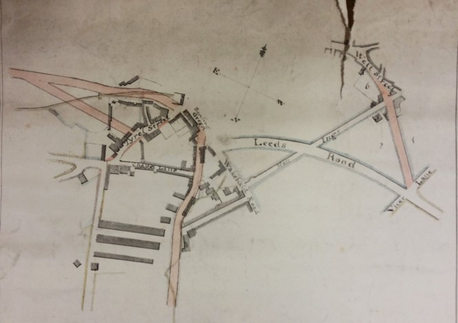
As I look at the old maps in the Local Studies Library I frequently find myself thinking ‘change and decay in all around I see’. A reflection which was occasioned by this week’s plan showing a dignified gentleman’s residence which was about to be replaced by terraced housing. What we have is a sale plan for a house called Whetley Hill dated 1872. It was located to the east of the road of the same name, just above the Lower Globe Inn.

Whetley Hill

This house would have provided an excellent opportunity for gracious living. The owner had a lawn, and kitchen gardens for fresh vegetables. Some tender plants required heat and I assume the melons and cucumbers grown in frames would have featured at fine dinner parties. Grapes might well have been provided as a dessert on such occasions and it only proper to have both an early and late heated vinery, so that the dinner guests could enjoy as long a season as possible. Transport needs were taken care of by a stable and coach house, and for relaxation there was croquet or a game of cricket. All could not be sweetness and light of course. I assume that the ‘soil shed’ was not a repository for potting compost but a storage area for human waste awaiting the arrival of the night-soil men with their cart. The ‘rubbish place’ was a convenient site for dumping coal ashes and broken pottery or glass in the years before a regular collection was provided by the local authority. Some lucky residents presumably now have an archaeological treasure house in their back gardens.

When was the house constructed, and who lived there? Immediately there is a problem. There were two houses at the same point on opposite sides of the roadway now called Whetley Hill. They are present on both the 1849 and 1871 Bradford borough maps. In 1849 our house is drawn, but not named. The house opposite is ‘Wheatley Hill’ with an ‘a’. In the 1871 map our house has adopted the name of its neighbour, and is itself Wheatley Hill, while the house opposite has become Wheatley House. This was a very thoughtless disregard of the needs of future local historians, and I assume that the respective butlers sorted out the misaddressed mail!

Such a large residence was hardly likely to escape the notice of William Cudworth and he records that Thomas Hill Horsfall was the owner of Whetley Hill in 1839, within a list of Manningham freeholders. Neither house was exactly a rural enclave. There were several neighbouring quarries and in the mid-nineteenth century Wheatley House must have had a fine view of a brick works. Cudworth explains that the mapped house, Whetley Hill, was built in the late eighteenth century by bachelor Thomas Wilkinson who owned most of the land in the area, and much else besides. Surprisingly on his death the housekeeper Miss Sally Kitching inherited. Cudworth describes her as ‘a maiden lady of means and of some repute’. When she died herself in 1822 Thomas Hill Horsfall (1802-1855) acquired the house from her executors. While resident he kept a pack of foxhounds that hunted all around Bradford. He was consequently known as ‘Hunting’ Tom Horsfall. Eventually he sold the house to John Priestman (1805-1866), around 1838 I estimate. It is fortunate that Tom was visiting his brother John Horsfall of Bolton Royds at the time of the 1851 census. It was their ancestor John Garnett Horsfall who introduced steam power looms to Bradford and the consequent riot at his mill in North Wing in 1826 led to several deaths when special constables fired on the protestors. The new owner of Whetley Hill, John Priestman, was a very different man to Hunting Tom. He was a Quaker, devoted to peace, and an enemy to none but strong drink. He was initially a flour miller and then a successful stuff weaver (John Priestman & Co.). After he died at Whetley Hill in 1866 his wife and sons continued in residence for a few years longer.

I’d really like to know more about Sally Kitching and the circumstances of her inheritance.  Cudworth does not give any indication of her age but he seems quite positive that she died in 1822. However I could get no independent confirmation of her death. Sally is a common diminutive of Sarah and there is a record that a ‘Sarah Kitching of Manningham’ was buried at Little Horton Lane Chapel (Independent) in 1827. Using Land Tax Redemption records it can be seen that in the mid-1780s Sarah Kitching owned one property in Manningham but the big land-owners were Sam Lister, Mr Hodgson and one Joseph Wilkinson. The crucial transition occurs in 1797-98. In 1797 Joseph Wilkinson owned five properties, the most valuable taxed at 13/9, and occupied another as a tenant of Mr Rawson (Lord of the Manor of Bradford & Manningham). In 1798 Miss Kitching retained her original property at the same tax value but acquired five more, again one with a tenancy from the Lord of the Manor. The name Joseph Wilkinson disappears and it can hardly be doubted that in 1798 Sarah Kitching inherited the property from Joseph Wilkinson, not Thomas as Cudworth states. It is no surprise to find that in April 1798 Joseph Wilkinson of Manningham, Gent, was buried at the parish church.

Cudworth gives the name of the last known resident as John Spink. By this time, he wrote, ‘the land below was covered by housing’. This great house is no more: ‘all our pomp of yesterday, is one with Nineveh and Tyre’.

Derek Barker, Local Studies Library Volunteer

Map of the Week: Bradford Centre

Map of the Week 003

Many maps and plans were drawn prior to planned developments that may, or may not, have actually taken place. There are two maps in the Local Studies Library reserve collection which evidently were produced to display the same projected roads leaving Bradford to the south and west. Here I have reproduced the large scale plan illustrating the town centre. It is not easy to interpret and I would be very happy to have my conclusions corrected by anyone more familiar with the evolution of our road transport links.

For a start the compass points are mislabelled, although the arrow head is pointing north as it should do. The top right corner of the map would have been clearer if the parish church had been included. Church Bank is approximately the continuation of the mapped Hall Ings, although much of Hall Ings has now vanished following development. Leeds Road is in existence which dates the map to later than c.1825-30 during which period the new turnpike to Leeds was constructed by the Leeds & Halifax Turnpike Trust. Is there any other indication of date? There is no suggestion of the the line of the Lancashire & Yorkshire railway from Halifax via Low Moor (opened 1850), so the map must be earlier than the late 1840s. The map almost certainly pre-dates Bradford becoming a borough in 1847.

The short pink road joining Well Street to Vicar Lane was built and still survives. It also took the name of Well Street and, resurfaced, it is between Little Germany and the new Broadway shopping centre. The end of Wakefield Road is modern Bridge Street. The real difficulty comes with the pink track directed north from the bottom centre of the map. Is this intended to be Manchester Road? No, Manchester Road must be the straight highway ending at the junction of Tyrrel Street and Chapel Lane. The pink road seems to be following the course of the Bowling Beck and the watercourse is presumably indicated by the faint superimposed wavy line. The Bowling Beck is now culverted but I believe it does lie well east of Manchester Road. What is the unnamed linking road joining the pink track to Wakefield Road? It is too far north to be Croft Street, which survives, but it is in the right place to be Union Street which was lost in the development around the Interchange. If I am correct then the pink road itself was never constructed but the second small scale map in the LSL enables one to project its further course. It would have joined Manchester Road just before Ripleyville.

As you can see in the town centre the planned road would have reached a point marked ‘bowling green’. After a short gap another road leaves westwards from two origins. I wondered if this was approximately the track of the future Thornton Road (constructed 1829). This works if Great Horton Road is the unnamed thoroughfare making a right angle with Manchester Road, but the pink tracks seem to start too far north.  Another superimposed faint line marks, I assume, the course of the Bradford Beck in which case the ‘box’ at the end of it would then be the Soke or Queens Mill. I cannot make the pink tracks fit with any roads I know, but in any case the  street plan here changed radically around 1870 with the creation of Aldermanbury and Godwin Street. The other small scale map brings the planned road to a junction with Brick Lane after which it does continue along the line of Thornton Road as far as I can judge. If I am right the illustrated map must date from the late 1820s after the construction of Leeds Road but before that of Thornton Road.

I am on firmer ground with the ‘bowling green’. This was an inn that once stood on Bridge Street. Cudworth mentions that in the 1830s its owner was a Mrs Susannah Ward, widow of Joseph Ward, about the time then that this map was being made. On-line masonic records suggests that the Bowling Green Inn was in existence in the late eighteenth century (c.1794) and William Scruton, in Pen & Pencil Pictures of Old Bradford, pushes that date back still further into the seventeenth century. He regarded the Bowling Green as ‘the best inn of the town’. It was used by the Royal Mail and the open space in front of the inn was seemingly employed for political meetings. Copies of Scruton’s book, which mentions many other former Bradford taverns, are to be found in the Local Studies Library. Also available is Michael Hopper’s History of Communications in Bradford up to the Period of the First World War.

Derek Barker, Library Volunteer

The Future of UK Sikhs – A Talk

On Saturday 19th March, Dr Ramindar Singh MBE gave a well-attended lecture in the Bradford Local Studies Library to mark the publication of his latest book, ‘The Future of UK Sikhs: A Bradford City Story’.

sikhs1


In the lecture Dr Singh presented his vision of the middle of 21st century Bradford Sikh community as a microcosm of the UK Sikhs, the focus of his book.

Following the talk Dr Singh led a discussion forum about the development of the Sikh organisations in the city, the current challenges they face and the ways to make them appropriate for the future of the community in the city. The interesting and thought provoking talk sparked much discussion and debate which continued long after the talk had finished.

sikhs2


Dr Singh has published books and a long list of articles on topics as diverse as economics, multicultural education, consumer affairs, race relations and local history.

His earlier publications, also available in the Local Studies Library include:

  • Punjab to Bradford: The Life Stories of Punjabi Immigrants to Bradford, 2013
  • A Journey by Choice: An Autobiography, 2011
  • Sikhs & Sikhism in Britain: Fifty Years On: The Bradford Perspective, 2000
  • Immigrants to Citizens: The Sikh Community in Bradford, 1992

There will be a further opportunity to hear the lecture at the Kala Sangam centre on 14th May 2016.

Map of the Week: Low Moor

In 1828 or 1829 surveyor Joseph Fox drew a map recording the property of the Low Moor Iron Company. The West Yorkshire Archives (Bradford) have a copy of his map, generously donated by Geoff and Mary Twentyman. The donors suggest that it was kept on display at the ironworks, and it has certainly been annotated at a later date. The original map is too fragile to be handled, a common problem with old material, but images of excellent quality are available on CD-ROM. The Local Studies Library reserve map collection also has a plan, labelled North Bierley, which closely resembles the Fox map. It has deteriorated quite badly but the detail included as this week’s chosen example perfectly clear.

The same landowners are mentioned in both maps, although the script in which their names are written differs. The plan of the Low Moor Ironworks is identical in the two maps, as are most buildings included. In the top left corner of the image are a collection of roughly circular features. These represent coal or ironstone mines. It is hard to imagine now that in the eighteenth and nineteenth centuries Bradford was densely covered by mines, abandoned mine-shafts and piles of colliery waste. The Low Moor and Bowling Iron Companies smelted iron ore, obtained locally from the roof of the Black Bed coal seam, using coke made from the deeper Better Bed seam. The production of cast iron and ‘best Yorkshire wrought iron’ was extremely profitable for more than a century.

In the approximate centre of the map is the place name ‘Glass House’. This represents the site once occupied by Bradford’s only known glass-making furnace. The builder of the glass-works, known to be in existence by 1748, was Edward Rookes Leeds (1715-1788) of Royds Hall, Lord of the Manor of Wibsey.  In that era the space needed for a furnace and its attendant glass-workers was enclosed by a brick cone, and there were large underground flues. An excellent surviving example of such a cone can still be seen at Catcliffe, South Yorkshire. The Fox map in the WY Archives places a large circle at this site which could easily represent a glass cone in plan, but the map illustrated here has no such feature. Have the two map versions ‘caught’ the brick cone in the process of being demolished?

The fate of the glass works is being actively researched at present. It is possible that the works was not in active production for many years, but ‘Glass House’ long remained as a place name in Low Moor. Fox drew other maps; the LSL reserve collection contains a beautiful example showing Harden Moor, with the roads connecting Keighley and Bingley, drawn in 1830.

Derek Barker, Library Volunteer

Low Moor

Map of the Week – Goitside

My job, as a Local Studies Library volunteer, is to review the maps and plans in the reserve collection. Many of these came from Bolling Hall Museum and are now in very a fragile condition. To make a complete assessment of each map would require a far more detailed knowledge of former Bradford than I can offer. Many local historians have kindly helped me by looking at images of maps from their chosen areas. I’m very grateful to them. My intention is identify and catalogue the locality of each map or plan, and also to provide an approximate date. If you discover a mistake please never hesitate to correct me.

The reserve collection is inevitably selective in its portrayal of nineteenth century Bradford. Areas that were sold, developed, or involved in Corporation road-widening schemes, were likely to be surveyed. An example is provided by the accompanying map of Goitside. To explain: a goit or leet is an artificial channel which takes water from a river or beck to power a water-mill and then returns it, at a lower level, to the natural watercourse. Thornton Road was a turnpike created in 1827. The area of interest is between Westgate and Thornton Road crossed by Grattan Road (known until about 1900 as Silsbridge Lane) which runs down the slope diagonally from north-east to south-west.

In the selected map the ‘intended road’ shown being created, at the junction of Thornton Road & Aldermanbury, is modern Godwin Street. Sunbridge Road is not shown but was another modern creation. The Lord of the Manor had the medieval right to a corn-milling monopoly at the Soke Mill, which had stood above Aldermanbury for centuries. Bradford Corporation bought out this right  from Mary & Elizabeth Rawson in 1870. Soke Mill goit had taken water from the Bradford Beck and provided power for the mill; it is likely to have been a medieval creation. The cluster of buildings round the mill includes a blacksmith’s and a small school. The whole area was cleared by the 1870s.

Godwin Street is present on the 1871 Bradford Dixon & Hindle map of Bradford, but not an 1861 equivalent. The late 1860s would be an approximate date for the illustrated map. Another reserve map shows that the intention of the planners was to raise the ground surface to culvert the Goit and to finally create Godwin Street at a gradient of 1:12 well above watercourse. The tithe map suggests that the origin of the Goit was from the Bradford Beck near Water Lane. Another reserve map shows a second goit being taken from Middle Brook to service a building called Sam’s Mill.

Derek Barker

Goitside