
Old plans of Heaton, my own part of Bradford, are not very common in the Local Studies Library map collection. In the late 18th and early 19th centuries a great deal of the land in the township was owned by the Field family. On the death of John Wilmer Field in 1837 this estate passed quietly, by virtue of the marriage of his daughter Mary, to the future Earl of Rosse. Land sales often generated surveyed plans and it is not surprising that the area identified in the first map was not part of the Rosse estate and so did change hands.
The 3rd Earl of Rosse died in 1867 so the map must be later than this date since his Countess is identified as a neighbouring landowner. She took over the direction of her Heaton and Shipley property until her own death in 1885. By this time portions of property was being offered for sale with villa development in mind. The present Earl of Rosse still maintains an archive at Birr Castle, Co. Offaly, Eire where many historic maps and documents are curated. But any questions readers might have about this area can almost certainly be solved more accessibly by consulting Heaton: the best place of all by the late Stanley King, the premier student of Heaton history. Several copies of his work are available on the library shelves.

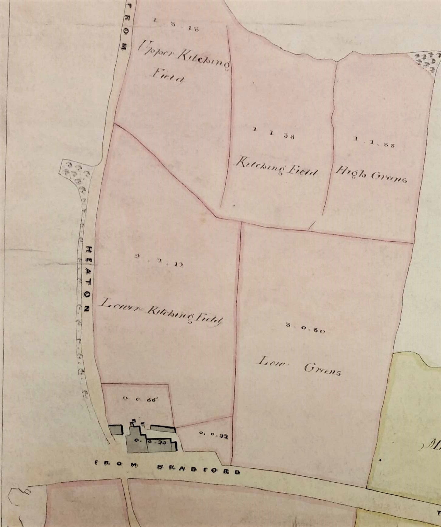
The map probably dates from c.1875 since it shows a block of land near the corner of Emm Lane and Keighley Road on which it was proposed to build Airedale College. This was to be dedicated to the training of Congregationalist ministers. An earlier college had been in existence at Undercliffe since 1831. The new premises at Heaton were opened in 1877 but the name was changed to United College in 1888, following the closure of a similar institution at Rotherham. The building is now part of the University of Bradford. Another part of the Emm Lane University Campus is an adjacent house named Heaton Mount which was built in 1863 by Robert Kell, whose name appears near the top of the map. Throughout this period Heaton did not form part of the Borough of Bradford; its incorporation was not until 1881. In fact the map even pre-dates the construction of Heaton’s first public sewer which, according to Stanley King, only occurred in 1877. The resulting sewage was discharged straight into the Bradford Beck which is really not a pretty thought. It looks as if the site destined for the college was part of a small parcel of land called the Turf Tavern Estate. The three field names are given as: Top Close, Quarry Field and Kitching Field.
The Local Studies Library has a second earlier map of 1840 which suggests that most of the area was then called Kitching Field, Kitching being a well-known local surname. Perhaps there was a small quarry here between 1840-75 that accounted for the name change. The Turf Tavern itself, briefly known recently as The Park, is present on this 1840 map and all the OS maps of Heaton. There is a datestone above the door carved with the year 1894, but this must indicate a rebuilding since the original structure was much older. Historian William Cudworth suggests that the tavern, and the nearby Branch Hotel (formerly the Coach & Horses), were both erected when the Bradford to Bingley turnpike was opened in 1825. He records that the builders of the Turf were William Clarke, a Heaton butcher, and his brother Joseph, a stonemason. Another brother, John Clarke, developed many delphs or quarries around Heaton village, although all evidence of those has long since vanished. The owner of the Turf Tavern estate at the time of the first map is likely to have been William Lister Marriner of Greengate House, Keighley. His family came into property around Frizinghall by marriage. Local historian Tony Woods has confirmed their possession of this area from the Heaton Local Board Rate Books 1860s-1881 (WYAS Bradford Archives BBT6/5/5/1-19). The same family also gave their name to Marriner’s Drive. This roadway is not present on the 1906 OS map but appears on the 1911 Rosse sale plan, without as yet any attendant houses.
The sale plans, of which the third map is an example, were produced because in 1911 the 5th Earl sold off all his remaining property in Heaton and Shipley.

What else does the first image show? Emm Lane was originally a track through Emm Field (perhaps originally Elm Field) when this was one of the three ‘great fields’ of Heaton in which farmers were allotted strips of land to cultivate. Nearby Manningham Park, now Lister Park, was originally a deer-park surrounding Manningham Hall, the home of the Cunliffe Lister family. The land was eventually purchased by Bradford as a public open space and Cartwright Hall, which opened in 1904, was built as an art gallery and museum. I’m not sure about the building in the extreme right of the map, above the words ‘to Bradford’. I think the same structure appears, sketchily drawn, at the bottom left of the second map. This area was called Carr Syke and there was known to be a turnpike toll house in this position. The fairly substantial building is drawn and identified in the Heaton tithe map but does not seem to be clearly indicated in the 1852 OS map for some reason. The Turf has recently been sold and I am not sure what future is planned for it. Hopeful the building will survive to feature in further Heaton maps.
Derek Barker, Local Studies Library volunteer
Discover more from Bradford and District Local Studies
Subscribe to get the latest posts sent to your email.
