
The Queens Road bridge, which carries the traffic from Manningham over Canal Road towards Bolton, Eccleshill and Idle, was in place when the 1889 OS map of the area was surveyed. The Local Studies Library reserve collection has a map from 1880 which seems to have been part of the preparatory planning for this structure. Early users, descending from Manningham, would have seen on their right the railway line and Valley Road coming from Bradford, very much as now. To their left, approximately where a stone reclamation site is now located, was Manningham Station. This pre-dated the bridge and was, in the years 1868-1965, the first stop out of Bradford on the Midland Railway (later LMS) line. Manningham and Frizinghall stations were closed, well within living memory, by Dr Beeching. Subsequently Frizinghall station has been reopened.
The three maps included in this article, though all undated, are clearly from the mid-twentieth century. Their relatively late origin has one great advantage inasmuch as their interpretation can be supported with photography.
The first map shows the situation on the city side of the bridge. To display the annotations correctly it has to be displayed with the city centre to the left of the map which doesn’t feel right to me. Valley Road should be running across the top of the plan but is not drawn. The canal is evidently ‘disused’ which places our plan quite certainly after 1922. The arrangement of the buildings resembles the 1930s OS maps quite closely, so that is a probable date.

The curved building that is aligned on Station Road, unnamed in this map, is a wool-combing mill. The blue waterway is the Bradford Beck and the idea behind the map, which is not explained, may have been to show how the beck could be culverted and taken under Canal Road at a time when a new sewer was being constructed. The six circles, and the ancillary buildings between them, represent the Bradford Gas Works. You can see this arrangement clearly in an image on the Britain From Above website:
Strangely the 1936 OS map does not name the Gas Works but does indicate that it was served by a network of railway lines which presumably distributed coal, arriving on trucks from the Midland Railway, to the coke ovens.
The second plan shows the same area but is orientated more naturally.
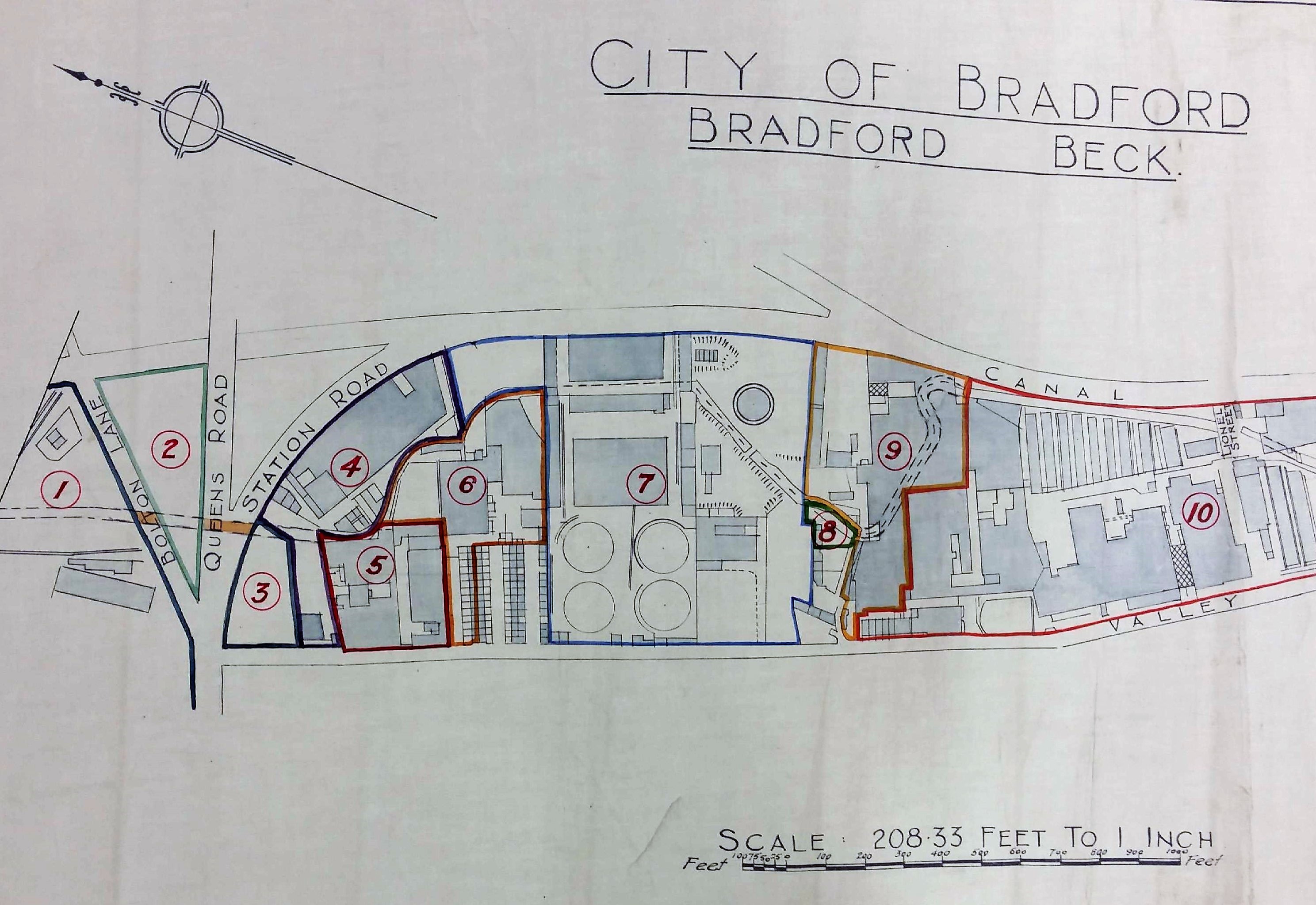
The map is undated but in the list below the railway is identified as London Midland & Scottish so it clearly pre-dates nationalisation in 1948. It is stamped ‘SG Wardley, City surveyor & engineer’. I believe Wardley was in post around 1946-1960s. Readers who have known Bradford longer than me will have their own views about whether the major city plan that he espoused produced bloom or blight. The great advantage of the second map is that land occupiers are clearly identified:
1 London Midland & Scottish Railway Company
2 Bradford Corporation
3 Bradford Corporation Street Drainage & Works
4 Bradford Woolcombers Mutual Association Ltd
5 Beck Properties Ltd
6 J F Raspin Ltd
7 The Bradford Corporation, Gas Committee
8 Wm. Whitaker & Co Ltd
9 R Clough & Co Ltd
10 The Bradford Corporation, Electricity Committee
Contemporary trade directories reveal that Raspin’s and Clough’s were both firms of commission wool-combers. The well-known Wm. Whitaker & Co Ltd were brewers until the 1920s but by the 1950s were bottlers and wine & spirit merchants. Unfortunately my limited research cannot place them securely in this position nor explain why they needed such a small patch of land. Can anybody help? Between Raspin’s mill and the Gas Works were three long-vanished roads: Hopwood St, Valley St and Valley Row. Small portions of the Bradford Beck are shown and the relationship of Canal Road with Valley Road is much clearer than in the first map. Towards the end of the 1930s gas production was abandoned at the Valley Road works which became exclusively a distribution centre. Production continued at Birks Hall works, Laisterdyke, eventually the largest in Yorkshire.
The final building on this map is the Valley Road Electricity Generating Station. I understand that its chimney was taller than the famous example at Manningham Mills. Its wooden-construction cooling towers were known as Davenport Towers. The works consumed millions of gallons of water, and hundreds of tons of coal, weekly. It had been built in 1896 and extended in 1939 and again in 1947.
In the Local Studies collection we have a plan of the whole Power Station of which the third map is a detail. The map is annotated ‘Electricity works, Canal Road’. The British Electricity Authority (Yorkshire Division) is recorded as the operator. I believe that this body was only in existence between 1948-55. The station was finally demolished in the mid-1970s.

Derek Barker, Local Studies Library volunteer.

