The Future of UK Sikhs – A Talk

On Saturday 19th March, Dr Ramindar Singh MBE gave a well-attended lecture in the Bradford Local Studies Library to mark the publication of his latest book, ‘The Future of UK Sikhs: A Bradford City Story’.

sikhs1


In the lecture Dr Singh presented his vision of the middle of 21st century Bradford Sikh community as a microcosm of the UK Sikhs, the focus of his book.

Following the talk Dr Singh led a discussion forum about the development of the Sikh organisations in the city, the current challenges they face and the ways to make them appropriate for the future of the community in the city. The interesting and thought provoking talk sparked much discussion and debate which continued long after the talk had finished.

sikhs2


Dr Singh has published books and a long list of articles on topics as diverse as economics, multicultural education, consumer affairs, race relations and local history.

His earlier publications, also available in the Local Studies Library include:

  • Punjab to Bradford: The Life Stories of Punjabi Immigrants to Bradford, 2013
  • A Journey by Choice: An Autobiography, 2011
  • Sikhs & Sikhism in Britain: Fifty Years On: The Bradford Perspective, 2000
  • Immigrants to Citizens: The Sikh Community in Bradford, 1992

There will be a further opportunity to hear the lecture at the Kala Sangam centre on 14th May 2016.

Map of the Week: Low Moor

In 1828 or 1829 surveyor Joseph Fox drew a map recording the property of the Low Moor Iron Company. The West Yorkshire Archives (Bradford) have a copy of his map, generously donated by Geoff and Mary Twentyman. The donors suggest that it was kept on display at the ironworks, and it has certainly been annotated at a later date. The original map is too fragile to be handled, a common problem with old material, but images of excellent quality are available on CD-ROM. The Local Studies Library reserve map collection also has a plan, labelled North Bierley, which closely resembles the Fox map. It has deteriorated quite badly but the detail included as this week’s chosen example perfectly clear.

The same landowners are mentioned in both maps, although the script in which their names are written differs. The plan of the Low Moor Ironworks is identical in the two maps, as are most buildings included. In the top left corner of the image are a collection of roughly circular features. These represent coal or ironstone mines. It is hard to imagine now that in the eighteenth and nineteenth centuries Bradford was densely covered by mines, abandoned mine-shafts and piles of colliery waste. The Low Moor and Bowling Iron Companies smelted iron ore, obtained locally from the roof of the Black Bed coal seam, using coke made from the deeper Better Bed seam. The production of cast iron and ‘best Yorkshire wrought iron’ was extremely profitable for more than a century.

In the approximate centre of the map is the place name ‘Glass House’. This represents the site once occupied by Bradford’s only known glass-making furnace. The builder of the glass-works, known to be in existence by 1748, was Edward Rookes Leeds (1715-1788) of Royds Hall, Lord of the Manor of Wibsey.  In that era the space needed for a furnace and its attendant glass-workers was enclosed by a brick cone, and there were large underground flues. An excellent surviving example of such a cone can still be seen at Catcliffe, South Yorkshire. The Fox map in the WY Archives places a large circle at this site which could easily represent a glass cone in plan, but the map illustrated here has no such feature. Have the two map versions ‘caught’ the brick cone in the process of being demolished?

The fate of the glass works is being actively researched at present. It is possible that the works was not in active production for many years, but ‘Glass House’ long remained as a place name in Low Moor. Fox drew other maps; the LSL reserve collection contains a beautiful example showing Harden Moor, with the roads connecting Keighley and Bingley, drawn in 1830.

Derek Barker, Library Volunteer

Low Moor

Map of the Week – Goitside

My job, as a Local Studies Library volunteer, is to review the maps and plans in the reserve collection. Many of these came from Bolling Hall Museum and are now in very a fragile condition. To make a complete assessment of each map would require a far more detailed knowledge of former Bradford than I can offer. Many local historians have kindly helped me by looking at images of maps from their chosen areas. I’m very grateful to them. My intention is identify and catalogue the locality of each map or plan, and also to provide an approximate date. If you discover a mistake please never hesitate to correct me.

The reserve collection is inevitably selective in its portrayal of nineteenth century Bradford. Areas that were sold, developed, or involved in Corporation road-widening schemes, were likely to be surveyed. An example is provided by the accompanying map of Goitside. To explain: a goit or leet is an artificial channel which takes water from a river or beck to power a water-mill and then returns it, at a lower level, to the natural watercourse. Thornton Road was a turnpike created in 1827. The area of interest is between Westgate and Thornton Road crossed by Grattan Road (known until about 1900 as Silsbridge Lane) which runs down the slope diagonally from north-east to south-west.

In the selected map the ‘intended road’ shown being created, at the junction of Thornton Road & Aldermanbury, is modern Godwin Street. Sunbridge Road is not shown but was another modern creation. The Lord of the Manor had the medieval right to a corn-milling monopoly at the Soke Mill, which had stood above Aldermanbury for centuries. Bradford Corporation bought out this right  from Mary & Elizabeth Rawson in 1870. Soke Mill goit had taken water from the Bradford Beck and provided power for the mill; it is likely to have been a medieval creation. The cluster of buildings round the mill includes a blacksmith’s and a small school. The whole area was cleared by the 1870s.

Godwin Street is present on the 1871 Bradford Dixon & Hindle map of Bradford, but not an 1861 equivalent. The late 1860s would be an approximate date for the illustrated map. Another reserve map shows that the intention of the planners was to raise the ground surface to culvert the Goit and to finally create Godwin Street at a gradient of 1:12 well above watercourse. The tithe map suggests that the origin of the Goit was from the Bradford Beck near Water Lane. Another reserve map shows a second goit being taken from Middle Brook to service a building called Sam’s Mill.

Derek Barker

Goitside

Undercliffe

UNDERCLIFFE is set just to the north east of the city centre of Bradford, its main artery being Otley Road. The first mention of the area was, according to C. Arthur Sugden, in 1418, when a man named Robert Leggard was up before the Bradford Court ‘ ….charged with having taken stone from the lord’s soil, in his waste towards Undyrcliffe’.

Undercliffe3

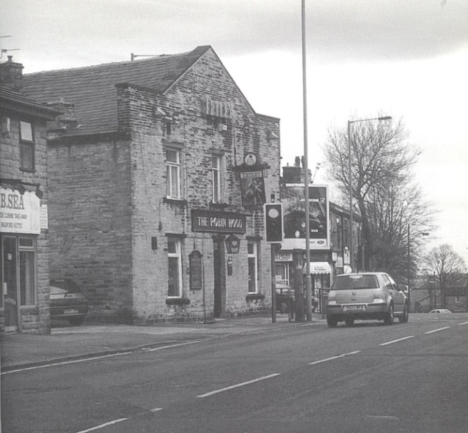
The now closed Robin Hood Pub, Harrogate Rd 2002 (Ann Birdsall)

The district was part of the moor of Bradford (now Bradford Moor). By 1611, Hundercliff, as it was then known, was a glebe in the West Riding of Yorkshire.  On Johnson’s map of Bradford (1802) most of Bradford Moor had been enclosed, and in the area of Hundercliffe the only buildings of note were a few farmhouses and Undercliffe House, built by John Hustler.  By 1880 however, a great transformation had taken place in the area. Undercliffe House was now surrounded by buildings.  Quarries had sprung up and buildings had appeared everywhere.

Undercliffe today is 600 ft. above sea level, higher than its original position.  There is little doubt that the district got its name from the fact that the earliest settlements were built ‘under-the-cliff’.  But the village was ‘forced up the hill’. The expansion of Bradford pushed the village further and further towards Eccleshill to where it is today.

Undercliffe was the setting for the legend of the famous Bradford boar. During the mid to late 14th century, there was a ferocious boar that lived in Cliffe Wood on the moors of Undercliffe. The boar frequently drank from a well in the wood. The boar terrorized the populace and caused much damage to land and property; so much so that the lord of the manor offered a reward for anyone brave enough to slay the boar and bring its head to the manor house.

Undercliffe1

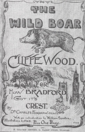
Cover of a poetry book by Dr Charles Forshaw, 1907.

A hunter took up the lord’s offer, and lay in wait near the well, ready to catch his quarry and thereby claim his reward. The boar duly arrived, and was shot by the hunter, who cut out the boar’s tongue as proof of his victory and set off for the manor house. A little time later, another hunter, who had heard of the lord’s offer, was passing through the woods and saw the slain boar lying near the well. Thinking of the reward he would receive, he cut off the boar’s head and he too set off for the manor house. Arriving there before the true victor, he claimed his reward for having disposed of the ferocious creature, but was unable to account for the boar’s absent tongue. The first hunter then arrived and explained the true circumstances of the defeat, showing the boar’s tongue as evidence of his veracity, and received his rightful reward; a plot of land called Hunt Yard in Horton.

Undercliffe today is renowned for its cemetery. It is possibly the most famous Victorian cemetery in Britain, outside of Highgate in London. Wealthy Victorians often lived quite modest, unassuming lives, but when they died they certainly left behind the most flamboyant memorials. Similar to the Egyptians, they showed a desire to display strength and prosperity in life and immortality and eternity in the after-life. The cemetery itself is not huge (around 25 acres) but it is crammed with magnificent memorials and monuments to the dead, especially those of the rich mill owners, wool barons and politicians of the Victorian era.  A walk round the cemetery today will reveal a mausoleum built like an Egyptian temple, complete with sphinxes, a Graeco-Roman temple with carved angels, and a Gothic steeple based on the Scott Monument in Princes Street, Edinburgh.  These are just some of the grander monuments. There are hundreds of other interesting, if less grand, gravestones of ordinary Bradford people, including many who died in the wars that affected the city from the Crimea onwards.

undercliffe4Undercliffe2

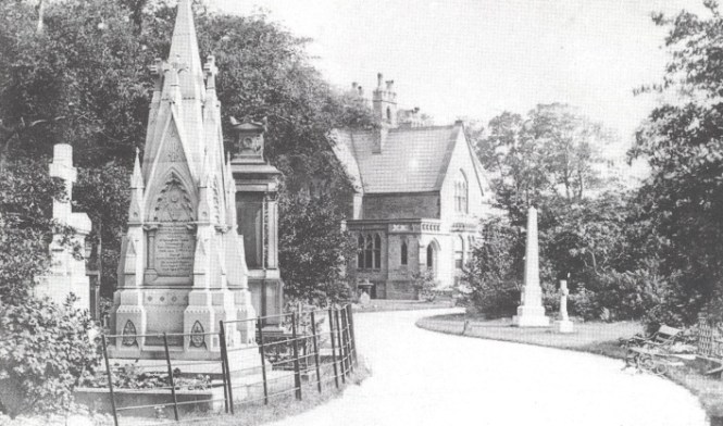
The cemetery is set in a stunning location, with great views over the city centre and the city as a whole. It is not uncommon to see film and documentary crews at work in the grounds. Go and take a look some time. It is a place of peace and tranquility set amongst this bustling city.

Further Reading

Sugden, A.C. Eccleshill and Undercliffe, in R.C. Allan The History of Bolton in Bradford-dale Robert C. Allan, 1927.

Beesley, I. Undercliffe. Bradford‘s Historic Victorian Cemetery
Ryburn Publishing. 1991


Humbert Wolfe, Bradford Poet

On 5th December the sculptured head of Humbert Wolfe, Bradford poet, was presented to City Library by Anthony Padgett, Sculptor. The sculpture was unveiled by the Lord Mayor of Bradford, Councillor Joanne Dodds, with a reading of Humbert’s poems by poet Stephen O’Connor.

hw

Humbert’s poem ‘Requiem’, published in 1927 is often read at Remembrance events.

Requiem: The Soldier

Down some cold field in a world outspoken
the young men are walking together, slim and tall,
and though they laugh to one another, silence is not broken;
there is no sound however clear they call.

They are speaking together of what they loved in vain here,
but the air is too thin to carry the things they say.
They were young and golden, but they came on pain here,
and their youth is age now, their gold is grey.

Yet their hearts are not changed, and they cry to one another,
‘What have they done with the lives we laid aside?
Are they young with our youth, gold with our gold, my brother?
Do they smile in the face of death, because we died?’

Down some cold field in a world uncharted
the young seek each other with questioning eyes.
They question each other, the young, the golden hearted,
of the world that they were robbed of in their quiet paradise.

I do not ask God’s purpose. He gave me the sword,
and though merely to wield it is itself the lie
against the light, at the bidding of my Lord,
where all the rest bear witness, I’ll deny.
And I remember Peter’s high reward,
and say of soldiers, when I hear cocks cry,
‘As your dear lives (’twas all you might afford)
you laid aside, I lay my sainthood by.’
There are in heaven other archangels,
bright friends of God, who build where Michael destroys,
in music, or in beauty, lute players.
I wield the sword; and though I ask nought else
of God, I pray to Him: ‘But these were boys,
and died. Be gentle, God, to soldiers.’

Bradford Local Studies library has an extensive collection of books and news cuttings by this best selling poet.

  • London sonnets (1920)
  • The Unknown Goddess (1925) poems
  • Humoresque (1926)
  • News of the Devil (1926) poems
  • Requiem (1927) poems
  • Cursory Rhymes (1927) poems
  • Others Abide (1927)
  • Dialogues and monologues (1928) criticism
  • This Blind Rose (1928) poems
  • Troy (1928) Faber & GwyerAriel poems
  • The Uncelestial City (1930)
  • George Moore (1931)
  • Snow (1931) poems
  • Signpost to poetry (1931)
  • Now a stranger (1933) autobiography
  • Portraits by inference (1934)
  • X at Oberammergau : A poem (1935) drama
  • The Pilgrim’s Way (1936)
  • The Upward Anguish (1938) autobiography
  • Out of Great Tribulation (1939) poems
  • Kensington Gardens in War-Time (1940) poems
  • Catalogue of printed books: the library of the late Humbert Wolfe (Sotheby)
  • Harlequin in Whitehall: a life of Humbert Wolfe by Philip Baggeley