From Parks to Pavilions

A photography exhibition illustrating the grass roots beginnings of Asian cricket in Yorkshire will be touring Bradford libraries over the coming weeks.

p2p

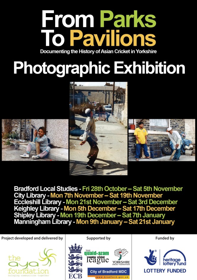
The exhibition contains photographs, taken by cricket enthusiast Mohanlal Mistry, of back-street cricket being played in West Yorkshire in the early 1990s. The exhibition has been displayed at Headlingley Cricket Ground for the one day international between England and Pakistan and at the Oval for the 2016 Asian Cricket Awards. This will be the first time that the exhibition is open to the public and free to visit.

It is part of the From Parks to Pavilions project which is documenting the history of Asian cricket in Yorkshire. The project was developed by the AYA Foundation, a community organisation specialising in promoting minority heritage, arts and culture, with support of Bradford Local Studies Libraries, the Yorkshire Cricket Foundation, the England and Wales Cricket Boards (ECB), and funded by the Heritage Lottery Fund.

This slideshow requires JavaScript.

Mobeen Butt, the curator of the exhibition and Project Lead of the From Parks to Pavilions project said: “The photographs perfectly capture how young Asians played cricket in the 1970s, ‘80s and ‘90s. They didn’t play on cricket grounds, in practice nets or even in parks – they played wherever they could, and that meant playing in alleyways, carparks and wastelands. They played with milk crates, traffic cones and crisp boxes for wickets and would carve out a bat from pieces of broken floor board or fence”.

The project aims to collect material and record interviews from members of one of the oldest Asian led cricket leagues in Britain, the Bradford based Quaid-e-Azam Sunday Cricket League.

As part of the project, the young people visited Bradford Local Studies library to find out about the oral history collection, the newspaper files and cricket memorabilia.

Maria Hussain, one of the young people working on the From Parks to Pavilions project said: “This exhibition is only a small part of our project. We’ve been to visit archives and museums. We’ve been to Lords, and we’ve been taught how to conduct oral history interviews and been on photography workshops. We will be producing a radio and video documentary and putting everything on YouTube for everyone to see!”

Councillor Sarah Ferriby, Bradford Council’s Executive Member for Environment, Sport and Culture, said: “It’s important to record the rich history of our South Asian communities participating in one of our great national sports. Cricket is still close to the hearts of local people and is a significant factor in community cohesion. We’re pleased to see the Heritage Lottery Fund get behind this as we have an enormous passion for sport across the Yorkshire region and it is a great unifier.”

To keep updated with the project visit: www.fromparkstopavilions.org.uk, follow @Parks2Pavilions on Twitter or join the ‘From Parks to Pavilions’ Facebook group.

All are welcome to take a look as it tours libraries in the coming weeks.

The exhibition will be in:

Bradford Local Studies Library from Fri 28th October – Sat 5th November
City Library from Mon 7th November – Sat 19th November
Eccleshill Library from Mon 21st November – Sat 3rd December
Keighley Library from Mon 5th December – Sat 17th December
Shipley Library from Mon 19th December – Sat 7th January
Manningham Library from Mon 9th January – Sat 21st January


Map of the week: Leeds Road and Market Street

This current example of a map from the Local Studies Library’s reserve collection is taken from a sepia plan which shows the eastern part of Bradford some years before it became a borough. Firstly it would help if we could establish a date. It is far earlier than the first OS map of 1849. The ‘new road’, running diagonally across the centre of the map, later became known as Leeds Road. This dates the map to later than c.1825-30 during which years this new turnpike to Leeds was constructed by the Leeds & Halifax Turnpike Trust. The pattern created by the other ‘new roads’ portrayed also exists on the Bradford plan of 1830, so we are probably looking at a map from the late 1820s.

leeds-rd

A coal staithe is a place adjacent to a highway from which merchants can collect a supply for subsequent delivery to their customers. The staithe here is marked J.S. & Co. Clearly this represents John Sturges (or Sturgess) & Co. which was the company that operated Bowling Iron Works. There were two original partners of this name, father and son, but they were presumably dead by the time this map was created. The ‘new rail road’ drawn is in fact a mineral carrying tramway bringing coal in trucks to the Eastbrook staithe, by rope haulage, from the iron works. Bowling Iron Company owned and operated many collieries and ironstone mines. The trucks may have been returned filled with limestone, needed for iron smelting, which would have arrived at the nearby canal basin from the quarries at Skipton. The tramway was closed in 1846 and the area is marked as an ‘old staithe’ in the first OS map of the area.

Let us look at some other roads. Wakefield Road, Bridge Street, and Hall Ings are in their present positions. ‘Dead Lane’ has subsequently been renamed Vicar Lane. Leeds Old Road is now Barkerend Road. As far as I can tell the numbered areas represent fields. Trees are growing west of the first section of Leeds Road and a rather larger wood is mapped there in the 1800 Bradford plan. There is second coal staithe (or stay) at the junction of Well Street and Hall Ings. This is evidently operated by J.J. & Co. whom I cannot identify. At the opposite end of Wells Street is another ‘new street’ which had been in existence for some years and has evolved into Market Street. Behind this is a rather sketchily drawn Bradford Beck. The surveyor of the map was evidently interested in the owners of property between Market Street and the beck and has added some names. You probably won’t be able to read these names, and in fact they are not easily legible even on the original map. As far as I can make out, reading from top to bottom, the names are: Green, Cowling or Crossley, Bradford, Wilkinson, Bank, Armytage, L Lumb, and Hustler.

There are directories listing Bradford business in 1822 and 1834. Plausible identification of most of these names in Market Street can be made from these directories although it is impossible to be sure.

  • Thomas Green, grocer and tea dealer 1834
  • David Crossley, attorney 1834
  • Bradford – uncertain
  • James Wilkinson, cabinet maker 1822
  • Thomas Jowett Wilkinson, cabinet maker 1834
  • Bradford Commercial Bank Co. 1834
  • Samuel Armitage, plumber & glazier 1834
  • John Lumb, straw hat maker 1822
  • Ann Lumb, pawn broker 1822
  • Thomas Lumb, pawn broker 1834

The name Hustler is more difficult. The famous Quaker wool-stapler and canal promoter, John Hustler, had died 1790. I believe he left two daughters. The fact that Market Street boasted two wool-stapler partnerships carrying his surname cannot, surely, be a coincidence. The two partnerships were Hustler & Blackburn and Hustler & Seebohm and I have confirmed the existence of both in other sources. I know that the Seebohms were another Bradford Quaker family. Can anyone fill me in on the exact relationships?

Derek Barker, Local Studies Library Volunteer

TREASURE OF THE WEEK. No. 2 – A RAMBLE ON RUMBOLD’S MOOR

In the basement of Bradford’s Local Studies Library are collections of nineteenth century pamphlets (and some of earlier date). Ranging from sermons and programmes of royal visits, to reports, articles, obituaries and regulations, they are a treasure-trove of local history. What follows is an account of one of these treasures. To consult any of these items please ask the staff. Card catalogues of these collections are located in the Local Studies Library.

JND 245/4 + 5 (Please quote this number if requesting these booklets)

C.F. and W.F. A Ramble on Rumbald’s Moor among the dwellings, cairns & circles of the Ancient Britons in the spring of 1868. Part II Counterhill & Castleberg.
20 pages. (Wakefield: W.T.Lamb, Printer and Publisher.)

C.F. and W.F. A Ramble on Rumbald’s Moor among the rocks, idols & altars of the Ancient Druids in the spring of 1869. Part III. 26 pages. (Wakefield: H.Kelly, Printer and Publisher.)

What delightful titles have these two pamphlets! Sadly the first of these three ‘parts’ is missing, though since only one hundred copies were printed this is no surprise. This, their age, and the fragile nature of the paper they were printed on, must make any remaining copies pretty scarce.

Our first pamphlet opens: “Who, after rambling among British dwellings, cairns and circles on that part of Rumbold’s Moor which extends from Burley Wood Head to Ilkley, could hear reports of Roman Camps on Counterhill and Castleberg, and not wish to visit them?” As indicated by the titles, these slim volumes give an account of early relics of past peoples, though an account of Addingham fills much of the first volume. A newspaper cutting inserted into the second volume here makes the point that the authors “drew attention to the sculptured rocks … recently discovered on Ilkley Moor.”

And who were C.F. and W.F.? A newspaper cutting inserted into the second volume here gives the authors as Charles Forest and William Grainge.

tres-2-ramble-on-rumbalds-charles-forest

Charles Forest

Some of the early historians, or ‘antiquarians’ as they were often called, have a bad reputation for making unsubstantiated assertions and promoting theories in the face of contradicting evidence, but not C.F. and W.F., according to the newspaper account, an obituary of Forest. It makes the point that he was careful in his research, and the text of these pamphlets bears this out, for the authors were often critical of other antiquarians.

There are a number of line drawings. These pamphlets are an early account of these remarkable relics on the moors. Though do take care if using them, else these scarce ‘relics’ will crumble to dust, unlike the relics they describe!

Stackmole

Map of the Week: Allerton Stone Extraction

The minerals exploited within Bradford were ironstone, coal, fireclay and sandstone. At one time there was also a small lime industry, in Bingley and elsewhere, based on the excavation of glacial limestone deposits brought by the ice from the Dales. After the Shipley to Skipton section of the Leeds-Liverpool canal was opened in 1774 there was a more direct means of access to the Skipton limestone quarries.  Ice movements would presumably have left substantial quantities of hard stone on the surface. This would need to be removed before ploughing in any case, but in regions where drystone walls were the traditional field boundaries there must have been a ready use for such material. Elsewhere resistant outcrops of rock protruded through the top soil from which potential wall stone could be removed with a hammer or crow bar. On some common land, or waste, local people may have had the right to remove such surface stone deposits. In Northcliffe Wood in Shipley there are a number of undated shallow excavations by means of which a band of sandstone called Stanningley Rock was accessed.

In many parts of Yorkshire it would have been possible to rob a Roman fort or the ruin of a dissolved monastery to obtain building stone, but not here.  In Bradford ‘delvers’ could obtain a good quality, honey coloured, sandstone. Quarrying is thought to have begun in this area in the seventeenth century and continued until the twentieth. The need for stone was perhaps greatest in the period 1860-1900 although the walls of many stone buildings in that era would have had an inner skin made from locally produced brick, which was cheaper. Stone winning processes are illustrated in these two plans of Allerton from the LSL’s reserve map collection.

The first plan is of Allerton Grange Quarry. The dated workings are from 1875-76. Towards the bottom of the plan you can see an extraction track. On the full map the track leads to Grange Lane. This name has been crossed out and ‘Dog Lane’ substituted in pencil. Dog Lane it remained until the post-war housing development of the area. The quarry seems to be marked as Upper Grange in the second OS map of the area (surveyed 1891). In 1905 a cricket pavilion was sitting on the site but by the 1930s it was fields again.

map-of-the-week-012a

The second plan shows an area south of Allerton village & Allerton Road, east of Hill Top Lane and north of Dog Lane. An extensive area of stone exploitation is indicated which not present on the first or second OS maps, but is present on the 1908 map. This plan was drawn by J Hindle, a well-known Bradford surveyor in partnership at various times with Charles Gott and Thomas Dixon. It is undated but is probably from the last decade of the nineteenth century. The important feature is that this is a stone mine, not a quarry. You may just be able to make out four ‘old shafts’ and a single ‘present shaft’. The pink areas represent stone already won or ‘got’, and evidently the land-owner has imposed a strict boundary to the exploitation. Good stone was not infrequently mined. Recently I was shown round some old mining sites in Shropshire where limestone was obtained in this way.

map-of-the-week-012b

What rock was exploited in Allerton? The local geological guides record Elland Flags being mined there. This is a sandstone stratum consisted of several bands of varying thickness and quality which were located under the Better Bed coal seam, itself extensively mined in south Bradford. The maps include no evidence of ownership although nearby Allerton Grange Farm was on Atkinson-Jowett land. Contemporary trade directories list many stone merchants situated in Allerton any of whom could have been involved with these sites.

Derek Barker, Local Studies Library Volunteer

Keighley’s Neglected Poet: a talk by Ian Dewhirst MBE

To celebrate National Poetry Day on October 6th, well-known author and historian Ian Dewhirst MBE will be giving a talk ‘Gordon Bottomley, Keighley’s neglected poet and playwright’ in Keighley Local Studies library.

Born in Keighley in 1874, Gordon Bottomley was an important figure in the poetry movement before and during the First World War and one of the most influential literary figures to have been born in Keighley.

Over the years, Mr Dewhirst has made a special study of Gordon Bottomley, for whom he has a great deal of admiration, and we are fortunate that this renowned raconteur has agreed to share his knowledge in this unique talk to be held at Keighley Library.

The talk starts at 11.00am. Admission is free and all are welcome.

gordon-bottomley-keighley-poet


Gordon Bottomley (1874-1948)
Keighley’s poet, writer, playwright, art collector

Gordon Bottomley is one of the most important literary figures to have been born in Keighley.  Despite the limitations he faced in society due to illness, his cultural reach extended into the national arts scene including drama, poetry and fine art.  As well as honorary degrees, Bottomley was a Fellow and Benson medallist of the Royal Society of Literature and Vice-president of the British Drama League.  In 1994, a blue plaque, similar to those for famous London landmarks, was put up to mark the site of his birth in Keighley.

Born in 1874, the only child of Alfred Bottomley, a Keighley accountant and his wife Maria, a Scot, he was initially educated by his mother. He then attended the Keighley Trade and Grammar School, part of the Mechanics’ Institute building which later became Keighley Boys’ Grammar School. Gordon Bottomley credits the school as a major influence on his literary development and Keighley Library holds the records of the school which reveal to some extent the kind of education and facilities available.

At the age of 16, he became a junior clerk at the Craven Bank in Keighley. In 1891 he was transferred to the Bradford branch but ill health (haemorrhaging of the lungs) left him an invalid for long periods of time. When he was 18 years old, the family moved to Cartmel area on the Cumbria-Lancashire border. Bottomley stayed in the area for the rest of his life, moving to The Sheiling, in Silverdale near Carnforth in 1914 with his wife Emily. Here they entertained friends such as Paul Nash, the artist, and Edward Thomas, the poet, and his correspondence with both these influential men has since been published.

Gordon Bottomley began writing poetry in earnest in the 1890s and became a leading figure in the Georgian Poetry movement before, and during, WW1. He had seven collections of poetry published and his works appeared in anthologies of the time.
He was also a playwright, mainly of one-act verse plays and he also championed the experimental theatre of the 1930s. He loved art, and became a dedicated collector. Greatly influenced by William Morris and the Pre-Raphaelites, he acquired a nationally important collection which also included the work of influential contemporary artists such as Paul Nash, Stanley Spencer, William Nicholson and Bradford’s own Sir William Rothenstein.  In 1949, he left over 600 paintings, drawings and prints to the Tullie House Museum and Art Gallery in Carlisle. Details of his collection are available in archive BK60.

gordon-bottomley

Keighley Local Studies Library Resources

Gordon Bottomley’s works are out of print now but Keighley Library has an important collection of his publications, photographs and published and original correspondence housed in the Library’s Yorkshire Authors’ Collection and in the archive.

The library also holds news cuttings and biographical articles, including some written by local historian and former Keighley Reference Librarian, Ian Dewhirst MBE.

A leaflet has also been produced outlining Gordon Bottomley’s life, works and original archive resources stored in Keighley Local Studies Library.