Map of the Week – Goitside

My job, as a Local Studies Library volunteer, is to review the maps and plans in the reserve collection. Many of these came from Bolling Hall Museum and are now in very a fragile condition. To make a complete assessment of each map would require a far more detailed knowledge of former Bradford than I can offer. Many local historians have kindly helped me by looking at images of maps from their chosen areas. I’m very grateful to them. My intention is identify and catalogue the locality of each map or plan, and also to provide an approximate date. If you discover a mistake please never hesitate to correct me.

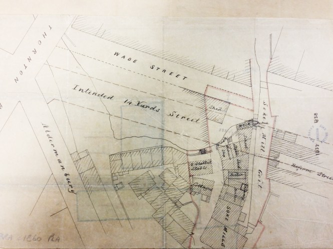
The reserve collection is inevitably selective in its portrayal of nineteenth century Bradford. Areas that were sold, developed, or involved in Corporation road-widening schemes, were likely to be surveyed. An example is provided by the accompanying map of Goitside. To explain: a goit or leet is an artificial channel which takes water from a river or beck to power a water-mill and then returns it, at a lower level, to the natural watercourse. Thornton Road was a turnpike created in 1827. The area of interest is between Westgate and Thornton Road crossed by Grattan Road (known until about 1900 as Silsbridge Lane) which runs down the slope diagonally from north-east to south-west.

In the selected map the ‘intended road’ shown being created, at the junction of Thornton Road & Aldermanbury, is modern Godwin Street. Sunbridge Road is not shown but was another modern creation. The Lord of the Manor had the medieval right to a corn-milling monopoly at the Soke Mill, which had stood above Aldermanbury for centuries. Bradford Corporation bought out this right  from Mary & Elizabeth Rawson in 1870. Soke Mill goit had taken water from the Bradford Beck and provided power for the mill; it is likely to have been a medieval creation. The cluster of buildings round the mill includes a blacksmith’s and a small school. The whole area was cleared by the 1870s.

Godwin Street is present on the 1871 Bradford Dixon & Hindle map of Bradford, but not an 1861 equivalent. The late 1860s would be an approximate date for the illustrated map. Another reserve map shows that the intention of the planners was to raise the ground surface to culvert the Goit and to finally create Godwin Street at a gradient of 1:12 well above watercourse. The tithe map suggests that the origin of the Goit was from the Bradford Beck near Water Lane. Another reserve map shows a second goit being taken from Middle Brook to service a building called Sam’s Mill.

Derek Barker

Goitside

Snapshot of the Past

A surprisingly common enquiry at Local Studies, is for information on local photographers operating out of Bradford in the 19th Century. Often, customers have found an old photo with a photographers name on the back and are curious as to who this was, or perhaps they are serious scholars of all things photographic!

The Library holds an index of photographers compiled from old Trade Directories by Local Historian Ken Kenzie, and an extremely useful website with a great deal of information and examples of photographers work can be found at:
Leeds and Bradford Photographic Studios 1840-1910

img140-1

Undercliffe

UNDERCLIFFE is set just to the north east of the city centre of Bradford, its main artery being Otley Road. The first mention of the area was, according to C. Arthur Sugden, in 1418, when a man named Robert Leggard was up before the Bradford Court ‘ ….charged with having taken stone from the lord’s soil, in his waste towards Undyrcliffe’.

Undercliffe3

The now closed Robin Hood Pub, Harrogate Rd 2002 (Ann Birdsall)

The district was part of the moor of Bradford (now Bradford Moor). By 1611, Hundercliff, as it was then known, was a glebe in the West Riding of Yorkshire.  On Johnson’s map of Bradford (1802) most of Bradford Moor had been enclosed, and in the area of Hundercliffe the only buildings of note were a few farmhouses and Undercliffe House, built by John Hustler.  By 1880 however, a great transformation had taken place in the area. Undercliffe House was now surrounded by buildings.  Quarries had sprung up and buildings had appeared everywhere.

Undercliffe today is 600 ft. above sea level, higher than its original position.  There is little doubt that the district got its name from the fact that the earliest settlements were built ‘under-the-cliff’.  But the village was ‘forced up the hill’. The expansion of Bradford pushed the village further and further towards Eccleshill to where it is today.

Undercliffe was the setting for the legend of the famous Bradford boar. During the mid to late 14th century, there was a ferocious boar that lived in Cliffe Wood on the moors of Undercliffe. The boar frequently drank from a well in the wood. The boar terrorized the populace and caused much damage to land and property; so much so that the lord of the manor offered a reward for anyone brave enough to slay the boar and bring its head to the manor house.

Undercliffe1

Cover of a poetry book by Dr Charles Forshaw, 1907.

A hunter took up the lord’s offer, and lay in wait near the well, ready to catch his quarry and thereby claim his reward. The boar duly arrived, and was shot by the hunter, who cut out the boar’s tongue as proof of his victory and set off for the manor house. A little time later, another hunter, who had heard of the lord’s offer, was passing through the woods and saw the slain boar lying near the well. Thinking of the reward he would receive, he cut off the boar’s head and he too set off for the manor house. Arriving there before the true victor, he claimed his reward for having disposed of the ferocious creature, but was unable to account for the boar’s absent tongue. The first hunter then arrived and explained the true circumstances of the defeat, showing the boar’s tongue as evidence of his veracity, and received his rightful reward; a plot of land called Hunt Yard in Horton.

Undercliffe today is renowned for its cemetery. It is possibly the most famous Victorian cemetery in Britain, outside of Highgate in London. Wealthy Victorians often lived quite modest, unassuming lives, but when they died they certainly left behind the most flamboyant memorials. Similar to the Egyptians, they showed a desire to display strength and prosperity in life and immortality and eternity in the after-life. The cemetery itself is not huge (around 25 acres) but it is crammed with magnificent memorials and monuments to the dead, especially those of the rich mill owners, wool barons and politicians of the Victorian era.  A walk round the cemetery today will reveal a mausoleum built like an Egyptian temple, complete with sphinxes, a Graeco-Roman temple with carved angels, and a Gothic steeple based on the Scott Monument in Princes Street, Edinburgh.  These are just some of the grander monuments. There are hundreds of other interesting, if less grand, gravestones of ordinary Bradford people, including many who died in the wars that affected the city from the Crimea onwards.

undercliffe4Undercliffe2

The cemetery is set in a stunning location, with great views over the city centre and the city as a whole. It is not uncommon to see film and documentary crews at work in the grounds. Go and take a look some time. It is a place of peace and tranquility set amongst this bustling city.

Further Reading

Sugden, A.C. Eccleshill and Undercliffe, in R.C. Allan The History of Bolton in Bradford-dale Robert C. Allan, 1927.

Beesley, I. Undercliffe. Bradford‘s Historic Victorian Cemetery
Ryburn Publishing. 1991


New Family History Courses

Bradford Libraries in conjunction with Bradford College are pleased to offer two new courses.

The popular course, Family History for Beginners, is starting again at Bradford Local Studies and Keighley Local Studies Libraries.

Ilkley Library are pleased to announce the start of a new course: Discovering Your Family History Using Your Tablet.

Please see the posters below for more details.

fhb


TabletIlkley