Men did astonishing things at which one did not wonder till after

Great post on our WW1 Blog

Bradford Libraries's avatarBradford Libraries World War One Blog

I hated history at school. It seemed to be nearly all battles, maps with arrows showing troop movements and then failed treaties.

To a 1960s teenager, history only went to prove that Bob Dylan was right to cry ‘how many deaths will it take till he knows, that too many people have died?’

Strange then, 50 years or so on, that I should be planning a display for Shipley’s elegantly refurbished library to mark the centenary of the Battle of the Somme.

To be honest military history still doesn’t interest me that much. I don’t get excited about tactics or weapons and the finer points of uniform insignia pass me by.

But when I started to work my way through the pages of the Shipley Times & Express from 1914-18, I was quickly hooked by the stories of people who might have been my neighbours and friends if I had…

View original post 1,106 more words

Disruption to Services at Bradford Local Studies

Bradford Local Studies Library and West Yorkshire Archives will not be able to retrieve any material from the reserve collections in the basement between Wednesday 15th June and Saturday 18th June inclusive.

Back to normal Monday 20th June.

This is because the floor in the basement is being painted!

We are sorry for any inconvenience this may cause.

Map of the week: Bowling Beck 2

I should now like to take the course of the Bowling Beck from the point it reached on the previous map onwards into the town centre. You can see that the beck runs through a fully urban area. The owners of some of these premises were among Bradford’s most famous names. Understanding the road plan and the building occupancy has caused me many problems. Some of the puzzles can be solved by using other library resources such as trade directories and the nineteenth century Bradford Observer; others have needed shoe leather. A provisional date for the map would be 1850. No railway tracks are drawn although it is possible that the tracks were already in existence and the map maker chose to ignore them.

An 1800 town plan shows this area as totally rural in character. Everything now visible was developed from green field sites in the third and fourth decade of the nineteenth century. None of the institutions mapped are listed in the Pigot’s 1834 trade directory but the library has a freehold sale plan, dated 1847, by which time the road plan was essentially complete. This sale plan shows the Union Foundry which was built by Quaker ironfounder Robert Crosland in the 1830s, and the Britannia Mill, erected in 1836. A good deal of land is owned by the partnership of William Greenwood and Benjamin Berry who made spinning frames at Prospect Mill, Bowling and Portland Mill. Another landowner was worsted spinner John Wood of Horton Hall, either alone or with his partner as Wood & Walker.  Wood played a vital role in establishing ten hour work days at textile factories. He removed to Hampshire in 1835 and his partner was a very different type of man.

Bowling Beck 2a Final

The Bowling Beck passes close to St James’s church school. I assume that the school was constructed in the years 1838-40 along with the church itself. The boys and the girls were evidently kept strictly separate. Flowing northwards the beck next crosses Queen Street and Duke Street, then enters a culvert. Note the Bowling Coal Depot; the first OS map of the area, surveyed in the late 1840s, suggest that this was supplied from the railway line rather than by mineral ways from local pits. A fragment of one line, supported on stone pillars, still remains near the Mill Lane signal box. It is not easy to reconcile the street names on the plan with those now on the ground. Queen’s Street was soon extended to form Caledonia Street which initially ended at the railway line. About 30 years after this map was drawn (around 1875) this street was taken over the tracks by means of a bridge which survives. Remarkably this change was suggested by an anonymous letter to the Bradford Observer. The rail tracks were originally taken by a short tunnel under Chandos Street, Bedford Street and Croft Street. These streets and the tunnel were swept away, also in the 1870s I would assume, and Croft Street was reconstructed as a bridge. Queens Cut and Cross Street are now renamed as Nelson Street. Portland Street retains its original name but has been truncated.

The Waterloo works (Hargreaves & Kennedy) was an example of the many Bradford foundries catering to the needs of house and factory. Among the iron goods produced might be drain covers, railings, cast iron support pillars, cooking ranges, pipes and textile machinery. Between Victoria Street and Portland Street the culverted beck runs under the Britannia Mills and weaving shed. Britannia Mills were operated by a very famous textile manufacturer, Christopher Waud, who spun yarn from mohair and alpaca. I must not give the impression that this whole area consisted wholly of major industries. According to the 1850 Ibbotson’s Directory of Bradford Andrew Bairstow was a hairdresser in Queens Cut close to Britannia Mill, and nearby in Portland Street Henry Farrand dealt in ‘fruit, eggs and herrings’. These ‘silver darlings’ was caught by the million in the North Sea and, cleaned and salted, formed an important food item for the poor.

The Bowling Beck clipped the site of the Portland Foundry and ran under Croft Street past a small ‘gas house’ close to the Union Foundry where Robert Crosland made hydraulic presses. The beck’s rather irregular course seems to include an open section. At the origin of the old Nelson Street the beck is certainly open. This may have lent interest to any patrons standing at the back of the Turk’s Head Inn. Actually ‘inn’ may have been a euphemism. The Turk’s Head appears in the Bradford Observer from time to time but it is always described as a ‘beer shop’. In 1840 its owner, John Smith, was denied a licence at the Brewster sessions but the Turk’s Head was open again by 1845 when it got Squire Auty, constable of Horton, into serious trouble. Auty had attended a supper there but, having noticed card playing, did nothing to stop it. If the Turk’s Head customers did stand by the beck its reported state would probably not have encouraged them to linger. The effluent from Bowling Dye Works was considered especially noisome even by Bradford standards. If the beer shop sold its own brew it is to be hoped that they had access to some less deadly source of water.

Bowling Beck 2b Final.JPG

The Bowling Beck passed another town centre worsted mill and then Chapel Lane. We lose the watercourse at this point on our map but it has to link up with the Bradford Beck, then open across the town centre. The 1800 town plan shows that Bowling Beck turned sharply east at this point and under Cuckoo Bridge over which passed Goodman’s End (now Bridge Street). It than took a short angled course finally to join the Bradford Beck itself. I hope I can convince you that you can pass a very pleasant afternoon in the LSL recalling bits of old Bradford to life. If you would like further information about the Bradford Beck, and its tributaries, the Friends of Bradford Becks are slowly bringing the hidden waterways back into public consciousness. I can recommend their website:

https://bradford-beck.org/


Derek Barker, Local Studies Library Volunteer

Map of the week: Bowling Beck 1

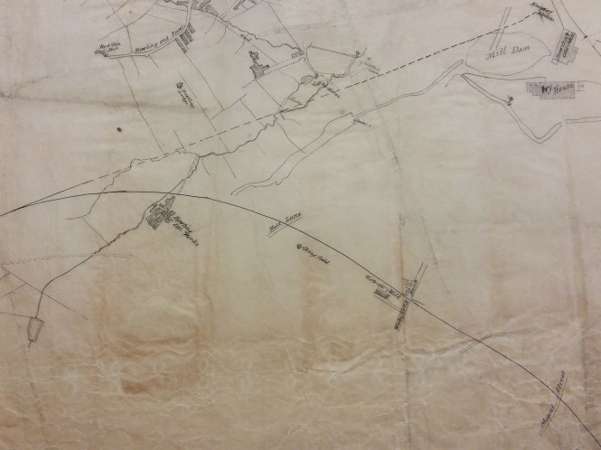
The next two maps from the Local Studies Library reserve collection will feature the Bowling Beck. This first map covers quite a wide area of south Bradford and must date from the mid-nineteenth century. It provides little internal evidence of its original purpose but I think unquestionably the main interest of its creator must have been in the watercourses. I’m ashamed to say that until I started studying this topic I used to talk vaguely about ‘tributaries of the Bradford Beck’, but all such branches once had individual names. The Bradford Beck proper flows into the city to the south of Thornton Road. Out of sight in culverts it turns almost 90 degrees and flows out towards Shipley, roughly parallel to the canal, to meet the River Aire. Its main tributary, the West Brook (formed from the junction of Horton Beck and Shear Beck) is still visible flowing in front of the Phoenix Building at the University, and joins the Bradford Beck near the site of the old Beehive Worsted Mills, Thornton Road (A. Flather & Sons). Neither beck is mapped here. What you can see are the Law (or Low) Beck, to the left, the last section of which has been straightened and possibly culverted. It joins the Bowling Beck, to the right, above Bowling Old Mill at a point marked ‘a’. Goits, dams and sluices are also mapped.

Bowling Beck

Subsequently someone has identified points along the Law Beck with letters of the alphabet. Between L & M, near Chapel Green, a user has hand-written ‘pit quarry’. The original map-maker was not at all interested in the extraction industries. In reality the whole area would have been covered by both working and disused collieries and quarries, as the first OS map of the area illustrates. The lower part of the map would also have been crossed and recrossed by mineral ways supplying Bowling Iron Works with iron ore and coking coal.

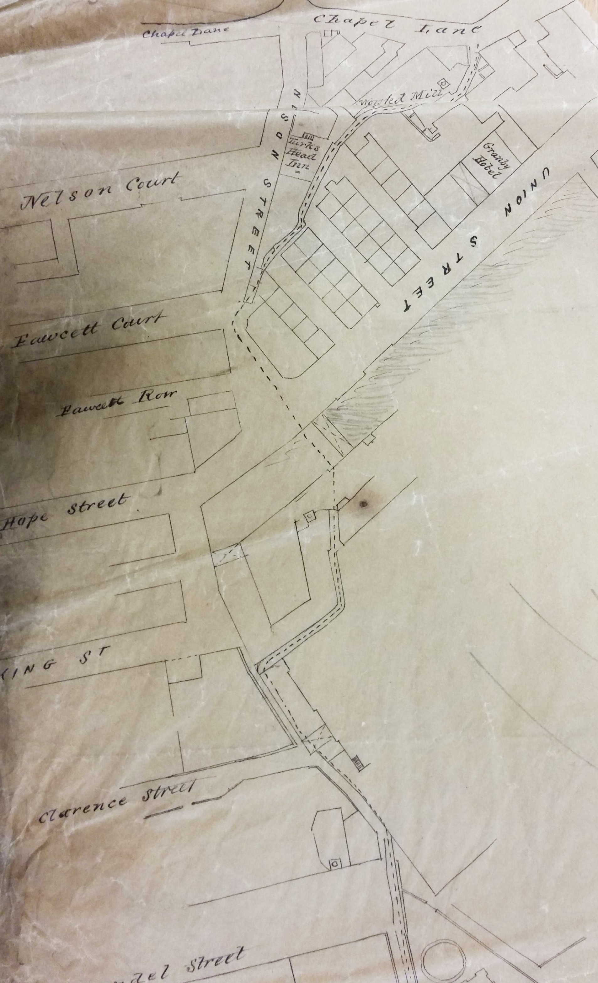
Determining the map’s exact date is quite difficult. The overall arrangement of buildings closely resembles the 1849 borough map. It is odd that St James’s Church (constructed 1838) is not drawn. A straight but interrupted line marks the course of the Lancashire and Yorkshire Railway into Drake Street (Exchange) Station after 1850, although the station itself is not mapped. The curved track from Bowling Junction to Laisterdyke is represented by a continuous line. This track, constructed in 1854, enabled Halifax to Leeds trains to avoid delays caused by entering and reversing out of Bradford. I assume that, since none of the stations or junctions are named, the lines were added after the map was drawn or perhaps when it was copied from an older original. I cannot say why the Adolphus Street station to Leeds line, also opened in 1854, was not included.

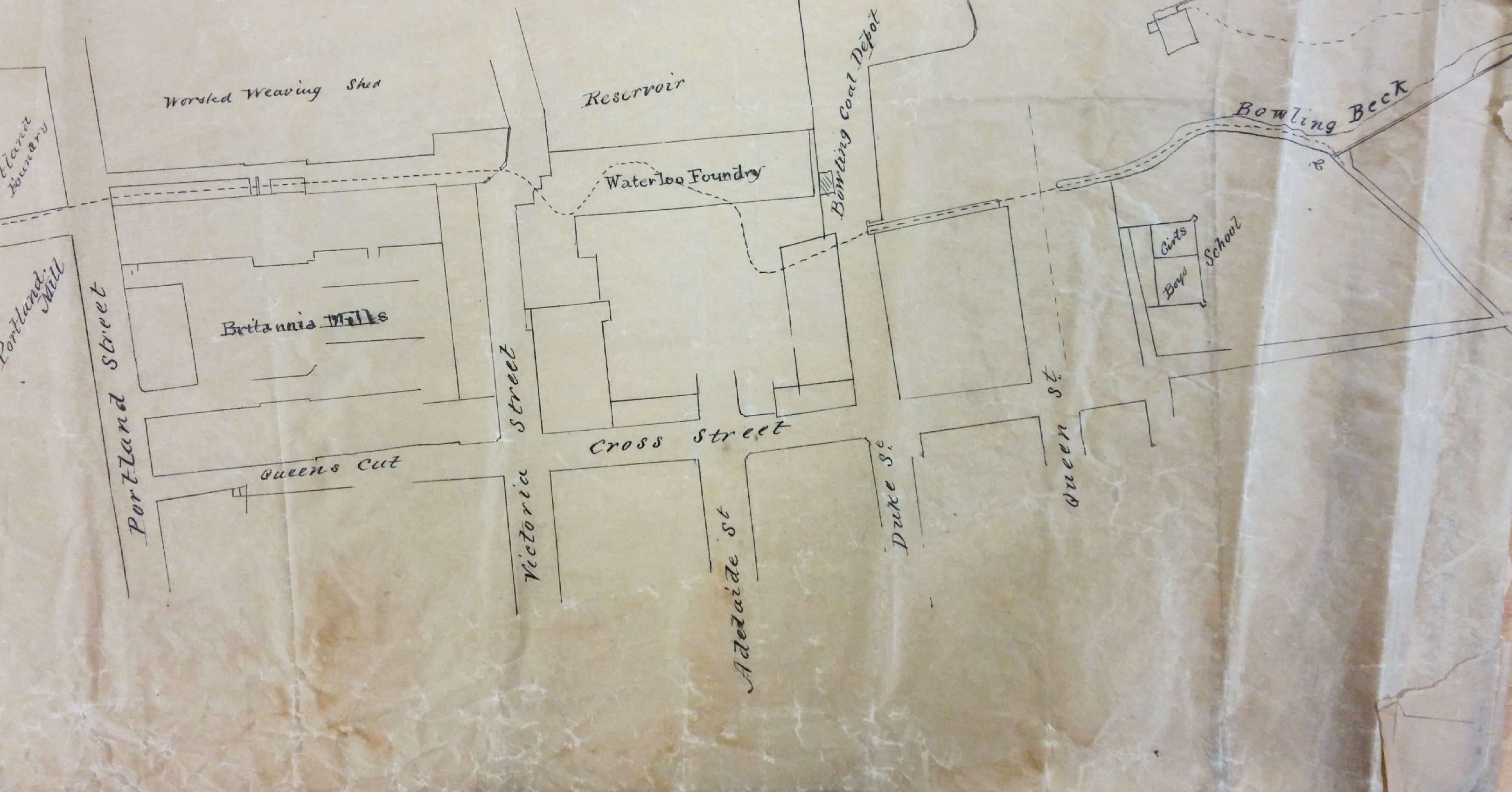
It is interesting to note that although south Bradford is largely rural both Bowling Dye Works and Bowling New Dye Works are present. Soft Yorkshire water was found to be very satisfactory for dyeing. Bowling Dye Works had been built at Spring Wood in 1822 but the business had been founded much earlier by the grandfather of a Bradford immortal, Sir Henry William Ripley (1813-1881). An aerial photo of the works, taken by CH Wood, is available on the Bradford Museums and Galleries website. What is missing on this map is its huge reservoir and several dye pits which are clearly present on the 1849 borough map. I’m not sure exactly when the New Dye Works was constructed but it was certainly in existence by 1849. Between the two works you can see Bowling Lodge, built for Sir Henry William Ripely in 1836. But, as a builder, Ripley is most famous for his creation of a model village, Ripleyville, beginning after 1866 and continuing until his death. This included terraced housing and almshouses. Strictly speaking Ripleyville was Bradford’s only industrial village since Saltaire was constructed in the then independent township of Shipley. Everything was demolished and redeveloped in the 1970s.

Rather confusingly in the ‘V’ formed by the two railway lines is drawn what appears to be a large artificial lake and sluice. This is simply an enlargement of the same feature drawn, at a much smaller scale, to the left. The watercourse ends at a Mill Dam overlooked by Ivy House and Bowling Old Mill. A body of water existed in Bowling Mill Field as early as 1839 because a little boy was reported drowned in it.  It stood in a field called Mill Holme. The corn mill itself was certainly present a century earlier than this map when the miller was one Reuben Holmes. The mill may have had a much earlier foundation still, associated with the Manor of Bowling. Cudworth records that a walk along Bowling Beck was notable for rabbits and partridges.

To draw the water supply to Bowling corn mill twice must indicates its importance to the maker of this map. Could this have arisen from a notorious legal case around this time? Henry Ripley had some highly controversial plans concerning south Bradford’s water supply which he had come to dominate in the area below Bowling Dye Works.

You can read about this dispute, and much else besides, on Bob Walker’s excellent Ripleyville site:

https://rediscoveringripleyville.wordpress.com

Derek Barker, Local Studies Library Volunteer

Map of the week: Whetley Hill

As I look at the old maps in the Local Studies Library I frequently find myself thinking ‘change and decay in all around I see’. A reflection which was occasioned by this week’s plan showing a dignified gentleman’s residence which was about to be replaced by terraced housing. What we have is a sale plan for a house called Whetley Hill dated 1872. It was located to the east of the road of the same name, just above the Lower Globe Inn.

Whetley Hill

This house would have provided an excellent opportunity for gracious living. The owner had a lawn, and kitchen gardens for fresh vegetables. Some tender plants required heat and I assume the melons and cucumbers grown in frames would have featured at fine dinner parties. Grapes might well have been provided as a dessert on such occasions and it only proper to have both an early and late heated vinery, so that the dinner guests could enjoy as long a season as possible. Transport needs were taken care of by a stable and coach house, and for relaxation there was croquet or a game of cricket. All could not be sweetness and light of course. I assume that the ‘soil shed’ was not a repository for potting compost but a storage area for human waste awaiting the arrival of the night-soil men with their cart. The ‘rubbish place’ was a convenient site for dumping coal ashes and broken pottery or glass in the years before a regular collection was provided by the local authority. Some lucky residents presumably now have an archaeological treasure house in their back gardens.

When was the house constructed, and who lived there? Immediately there is a problem. There were two houses at the same point on opposite sides of the roadway now called Whetley Hill. They are present on both the 1849 and 1871 Bradford borough maps. In 1849 our house is drawn, but not named. The house opposite is ‘Wheatley Hill’ with an ‘a’. In the 1871 map our house has adopted the name of its neighbour, and is itself Wheatley Hill, while the house opposite has become Wheatley House. This was a very thoughtless disregard of the needs of future local historians, and I assume that the respective butlers sorted out the misaddressed mail!

Such a large residence was hardly likely to escape the notice of William Cudworth and he records that Thomas Hill Horsfall was the owner of Whetley Hill in 1839, within a list of Manningham freeholders. Neither house was exactly a rural enclave. There were several neighbouring quarries and in the mid-nineteenth century Wheatley House must have had a fine view of a brick works. Cudworth explains that the mapped house, Whetley Hill, was built in the late eighteenth century by bachelor Thomas Wilkinson who owned most of the land in the area, and much else besides. Surprisingly on his death the housekeeper Miss Sally Kitching inherited. Cudworth describes her as ‘a maiden lady of means and of some repute’. When she died herself in 1822 Thomas Hill Horsfall (1802-1855) acquired the house from her executors. While resident he kept a pack of foxhounds that hunted all around Bradford. He was consequently known as ‘Hunting’ Tom Horsfall. Eventually he sold the house to John Priestman (1805-1866), around 1838 I estimate. It is fortunate that Tom was visiting his brother John Horsfall of Bolton Royds at the time of the 1851 census. It was their ancestor John Garnett Horsfall who introduced steam power looms to Bradford and the consequent riot at his mill in North Wing in 1826 led to several deaths when special constables fired on the protestors. The new owner of Whetley Hill, John Priestman, was a very different man to Hunting Tom. He was a Quaker, devoted to peace, and an enemy to none but strong drink. He was initially a flour miller and then a successful stuff weaver (John Priestman & Co.). After he died at Whetley Hill in 1866 his wife and sons continued in residence for a few years longer.

I’d really like to know more about Sally Kitching and the circumstances of her inheritance.  Cudworth does not give any indication of her age but he seems quite positive that she died in 1822. However I could get no independent confirmation of her death. Sally is a common diminutive of Sarah and there is a record that a ‘Sarah Kitching of Manningham’ was buried at Little Horton Lane Chapel (Independent) in 1827. Using Land Tax Redemption records it can be seen that in the mid-1780s Sarah Kitching owned one property in Manningham but the big land-owners were Sam Lister, Mr Hodgson and one Joseph Wilkinson. The crucial transition occurs in 1797-98. In 1797 Joseph Wilkinson owned five properties, the most valuable taxed at 13/9, and occupied another as a tenant of Mr Rawson (Lord of the Manor of Bradford & Manningham). In 1798 Miss Kitching retained her original property at the same tax value but acquired five more, again one with a tenancy from the Lord of the Manor. The name Joseph Wilkinson disappears and it can hardly be doubted that in 1798 Sarah Kitching inherited the property from Joseph Wilkinson, not Thomas as Cudworth states. It is no surprise to find that in April 1798 Joseph Wilkinson of Manningham, Gent, was buried at the parish church.

Cudworth gives the name of the last known resident as John Spink. By this time, he wrote, ‘the land below was covered by housing’. This great house is no more: ‘all our pomp of yesterday, is one with Nineveh and Tyre’.

Derek Barker, Local Studies Library Volunteer