
Bradford local historians are most fortunate in having the Local Studies Library and the West Yorkshire Archives (Bradford) under the same roof, each with helpful and dedicated staff. To illustrate the value of this I shall trace the history of a single building starting with the Local Studies Library reserve map collection which provides a detailed plan of the area between Bradford and Shipley. The plan is completely unlabelled but field boundaries and properties are meticulously drawn. A detail is included here which shows the canal and Bradford Beck at the bottom. A continuous line (red in the original) near the map centre must represent the railway to be opened by the Leeds & Bradford (later Midland) Railway Company in 1846. The discontinuous lines lines on either side were presumably an estimate of the land needed to be acquired by the company. The date of the map would be the early 1840s. From comparison with the first OS map of the area, surveyed a few years later, the track did follow exactly this route.
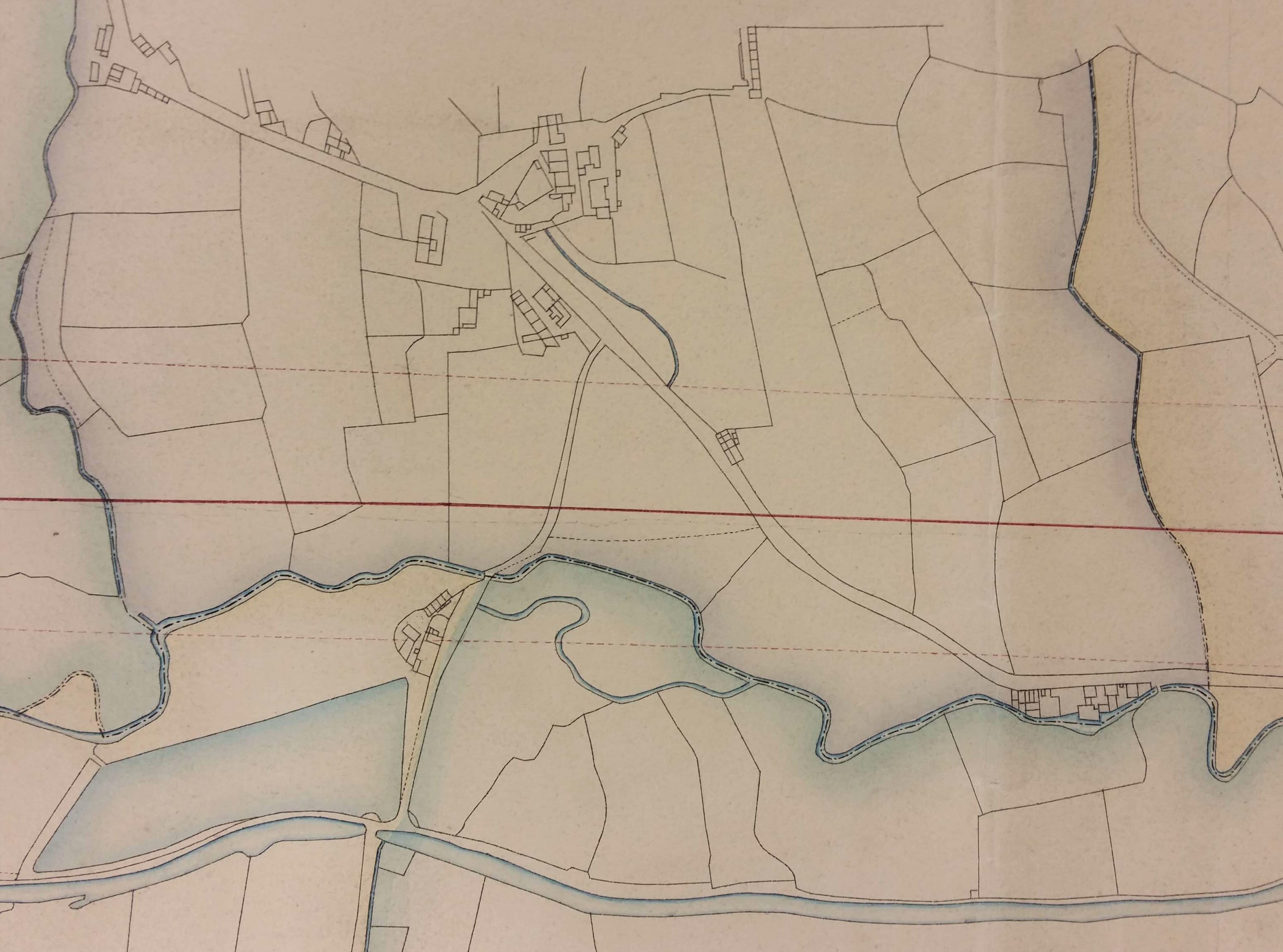
You would need to know this area very intimately to recognise the hamlet in the upper centre of the map as Frizinghall. This is now considered to be part of Heaton, which was not incorporated into the Borough of Bradford until 1882. To orientate yourself imagine you are standing in Bolton Woods: the direction of Bradford is to the left and Shipley to the right. The course of the beck has since been straightened and between it and the railway is the modern Canal Road, at roughly the position of the lower interrupted line. The thoroughfare drawn crossing the canal is Gaisby Lane. The next plan is a detail from a lovely Frizinghall map which is approximately contemporary with the first image. It is available in the LSL main collection.
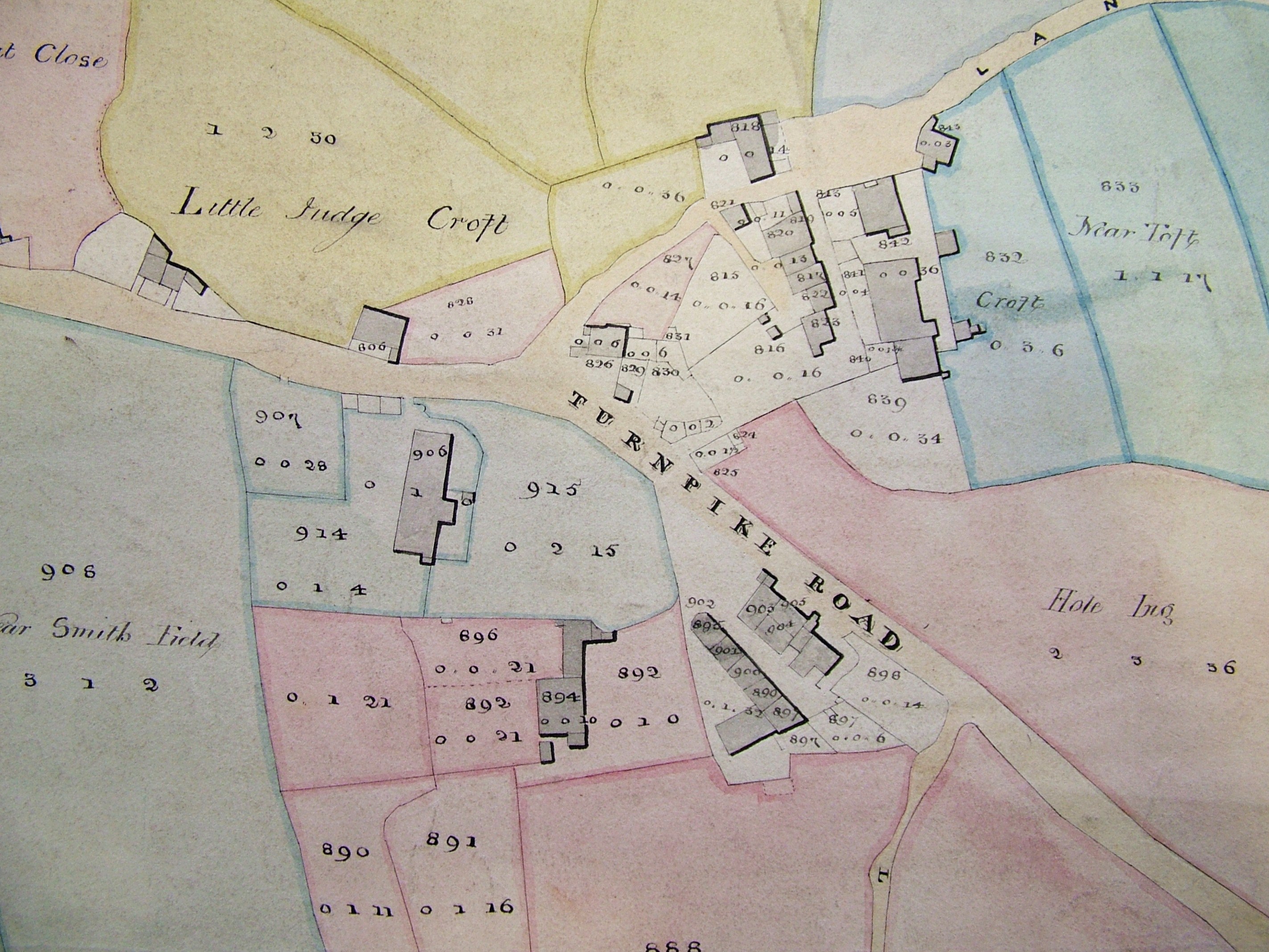
There was to be extensive house building over the next 50 years, probably after Frizinghall train station was opened in 1875, but many features on this map are still visible today. The three buildings in the lower third certainly still exist. The only one with public access fronts the turnpike road. This is the Black Swan public house; the triangle of land on which it sits was once called Swan Hill and is well above road level. The Black Swan must predate even this map by several centuries and is well worth a visit. From its car park the housing which looks like a laterally inverted L is also visible. The third building in the cluster is a private house then called the Old Hall.
My personal favourite is the building in the middle of the blue coloured land opposite the ‘turn’ of turnpike; this is still easily visible from the road. Although latterly called ‘The Old Barn’ when it was a pub-restaurant, the property was known as ‘The Poplars’ for much of the twentieth century. Earlier than that it was ‘Carr Syke Farm’ or ‘Lower Carr Syke Farm’. The Carr Syke was a watercourse, the name deriving from the Norse meaning ‘the stream in the marshy ground’. In the late eighteenth century the Carr Syke Farm seems to have formed part of the estate of Benjamin Hird of Frizinghall which was sold to a Dr Joshua Walker of Leeds in 1795. The estate passed to Dr Walker’s daughter Margaret, and then by marriage to a well-known Quaker, William Leatham of Hemsworth Hall, Wakefield. I believe it was owned by his family for the next 80 years. In 1883 the property was then sold to Bradford Corporation by William Henry Leatham and others. Two years later the property was purchased from Bradford Corporation by the Clockhouse Estate who retained it well into the twentieth century. Much of this portion of the estate eventually became the location of Bradford Boys Grammar School.
If you wish to learn even more a distinguished local historian, Lillian Robinson, wrote a detailed account of Frizinghall (the place of her birth) in the years 1973-75. This work does not seem to have been published but typescript copies are available in the Library (B942 ROB). The notes on which this work is based are available in the Archives (WYB140) and are as useful as the completed work itself. Earlier still M. Blundell Heynemann had written an account for The Heaton Review in 1931. She had this to say: ‘on the right, down a paved path, is the entrance to the Poplars, the residence of Mr Wilkinson, the Clock House Estate Agent. A farm, now demolished, formerly stood facing the road and only the old barn and stables still remain. It was farmed by a Mr Greenwood who went there in 1877’. The Bradford historian Cudworth clearly mentions, without directly naming, Lower Carr Syke Farm because of its association with William Wilson who once leased it: ‘another old homestead at Frizinghall, enclosed in its own grounds, was for some time the residence of a most exemplary Quaker family, named Wilson, originally of Esholt. One of the members of this interesting family, named Willie or ‘Quaker’ Wilson (1767-1849), enjoyed a reputation throughout the entire kingdom for his many eminent qualities as a philanthropist.’ Wilson was apparently able to retire at fifty years of age (that is in 1817) with a fortune of many thousands of pounds. This he methodically gave away to the poor over the next 30 years. He died, much lamented, in November 1849, aged 82, and his remains were interred in the Friends’ burial-ground, Bradford.
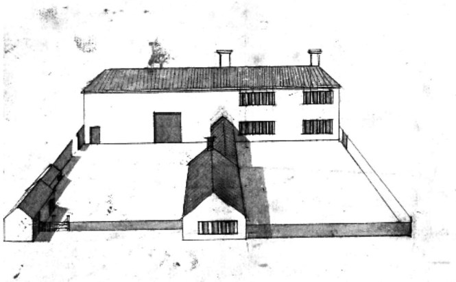
With the next two images the Archives comes into its own. Both are rotated 90° anti-clockwise from the first two. We have moved back a generation to Joshua Walker Sr. (1713-1801) who was also a Bradford Quaker, and an apothecary; he seems to have been an amateur architectural enthusiast who drew many house plans. It was his son, Dr Joshua Walker (1746-1817) physician at Leeds Infirmary, who had bought the Carr Syke estate. One of his father’s undated plans, available in the Archives, is labelled ‘Lister Patience’s Farm’; Heaton & Manningham’. The field boundary pattern fits Lower Carr Syke Farm. In this plan the present building would appear to be originally a barn which has two cottages (now missing) in front of it.

Another of Joshua Walker’s productions, WYA(B) 85D90 plan 45, is described as showing a ‘laithe house and yards’. There’s not much doubt that Lower Carr Syke Farm would have appeared very much like this when first arranged for human habitation. It is quite possible that the drawing does actually represent Lower Carr Syke Farm itself. The two cottage-like structures in the foreground could easily be those marked on the map of ‘Lister Patience’s farm’. I have not been able to trace ‘Lister Patience’, nor Patience Lister which sounds a more probable name. Can anyone help?
Derek Barker, Local Studies Library volunteer
Discover more from Bradford and District Local Studies
Subscribe to get the latest posts sent to your email.

My mother’s great grandfather Joshua Patchett had a farm at Carr Syke in the 19th century. Joshua left a detailed Will. If you would like further details, please contact me.
Carol Jennings
LikeLike
Hi Carol. Please email local.studies@bradford.gov.uk with your enquiry and they will get back to you.
LikeLike
Hello Derek,
I know a long time has passed since you wrote this piece and thank you very much for it. Are you still interested in discussion on this specific area, or have you moved on? If the latter I won’t trouble you any further and there is no need to respond. I was brought up in Frizinghall in the 1960’s & 70’s – I lived opposite the Turf on Keighley road, so I know the area well. I retired recently and am thinking of doing some local history work on Frizinghall. With Covid this has been restricted to internet research at home thus far, which is how I came across your article. My discussion would relate to the collection of properties at the top of Frizinghall road, also apparently called Carr Syke Farm or lower Carr Syke – at least according to the photograph 29 of 51 (search under Frizinghall in the Bradford museum and galleries photo archive). That photo is taken from within the collection of buildings at the top of Frizinghall road. To me it would make sense that the Old Barn represented the area of lower Carr Syke. But I also refer to the property apparently once called Lister villa, which is on the opposite side of Frizinghall road and about equal distant between the two plots referred to. Happy to have a discussion if you are interested.
Mike
mikebrotherton@blueyonder.co.uk
LikeLike
Thanks Mike: I reply to you direct,
LikeLike
Hello Derek,
Thanks for this article, I don’t know this area that well and am unable to answer your question, but was interested in the Fritzinghall name, specifically was there another, new, Fritzinghall, as the polar explorer Douglas Mawson was born in that family farm in this locality I understood, just prior to Robert, his father selling it (in 1884?), when his mother – the grandmother of Douglas – died there in 1882? I would be very interested in knowing more about Robert, and even his sister, Sarah Ann please, if you could point me in that direction, preferably revealing existing resources of this local family. (I even wondered if their selling the farm had much to do with urban sprawl, as your article alluded to?)
Cheers
Mark Pharaoh
LikeLike
Thanks for your comment Mark. To be honest I’ve always thought of Douglas Mawson as Australian so I have learned something. I am not a family historian: coal mines being more my line, but since he was born in 1882 I assumed I could find Douglas’s parents in the 1881 census of Shipley. If I have the correct family Robert Ellis and Margaret Mawson lived at 25, Shipley Fields Road. It would be stretching a point to call this Frizinghall, and Robert Ellis is a stuff (worsted) merchant’s manager – a very typical nineteenth century Bradford occupation. I presume that the farm must be earlier but in the 1871 census Robert Ellis and Sarah Ann are living with their widowed mother Mary Mawson in Otley. Robert (17 years) is then an apprentice stuff merchant. I would imagine you could find much more information on the major family history websites: good hunting!
LikeLike