Neglected Bradford Industries: Stone Quarrying

Bradford is famous for spinning and weaving but textile production was only one of a group of important industries which ‘Worstedopolis’ supported. Since several  are now almost forgotten by contemporary citizens I should like to draw attention to those which seem unreasonably neglected in a series of short articles.

It is the extent, rather than the existence, of Bradford’s stone quarrying industry that has tended to pass out of memory. Bradford sits on a series of Carboniferous period sedimentary rocks called the Lower Coal Measures. This series contains strata of commercially valuable fine grained sandstone such as the well-known Elland Flags. Beneath the Coal Measures is the Millstone Grit series which also provided building stone. Saltaire, for example, is constructed of gritstone. There is no essential difference between these two series of rocks, no unconformity as geologists would put it, and their junction is defined by a particular fossil species. Millstone Grit outcrops to the west and north of the city, forming the scenery of Shipley Glen and Ilkley Moor. The Aire Valley glacier once carved its way deeply into the Millstone Grit making it possible for this rock also to be exploited quite near Bradford. Sandstones and gritstones are largely composed of cemented grains of the hard mineral quartz. Ultimately these grains were derived from weathering igneous rocks and transported here, and deposited, by a vast river delta more than 300 million years ago.

Although stone was principally a construction material it did have other uses, dressed gritstone was once employed for the millstones in corn mills for example. Midgeley Wood at Baildon Green is said to show evidence of this industry, and I should be grateful if any reader could confirm this. Stone could also be crushed for gravel and sand. Any stone occurring in thick beds, which can be cut freely in any direction, is called freestone. Once hewn for facing it is known as ashlar. Gritstone and ragstone are sandstones with coarse, angular, grains that cut with a ragged fracture. Flagstones are thin bedded sandstones ideal for flooring and roofing. When this material is used on a roof it is often referred to as ‘stone slate’ although it is not true slate which is a metamorphic rock. There are plenty of true slate roofs in Bradford of course but slate came by rail, after the mid-nineteenth century, from Wales or, to a lesser extent, the Lake District. The colour of sandstone reflects its iron content. Local stone was often grey when first quarried but it oxidises, on exposure to air, producing a beautiful honey colour. Old quarries are a significant landscape feature in many parts of the Bradford area, and are commonly seen in tithe maps and the first OS maps. Many were subsequently used for land fill, recreational space, or development.

04 Image A

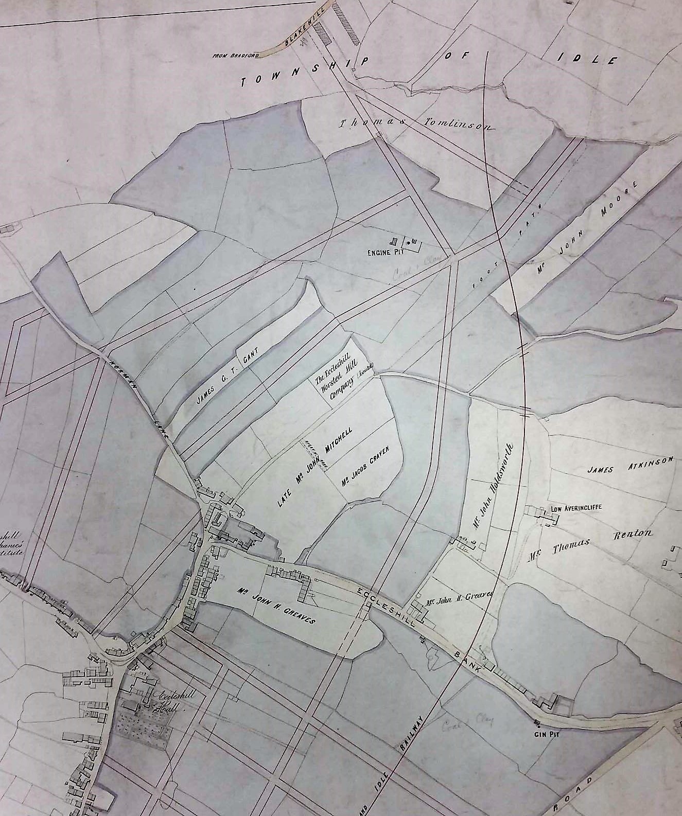
Quarries on Idle Moor in a detail from the first OS map of the area
(surveyed in late 1840s)

In the Middle Ages stone building was confined to high status structures: castles, churches, bridges, and great houses. The only medieval stone buildings now standing in Bradford would seem to be the tower of Bolling Hall and the Cathedral. There must have been a medieval stone quarry in Bradford since the recent Sunbridge Wells development exposed several prison cells, the rear walls of which are portions of a quarry face. Medieval vernacular architecture was in timber, thatch, wattle and daub. The construction of a large timber-framed house required carpentry of a very high order so I cannot think of timber construction as a second best to masonry. After the medieval period there was a ‘great rebuilding’ in brick and stone which in northern Britain occurred quite late, from the mid-seventeenth to early eighteenth century. Was this simply fashion, or an appreciation of the damage fire could do to a wooden urban area? As with many innovations the wealthy were the first to adopt the change. Paper Hall in Bradford is an early example in the city, and East Riddlesden Hall is a seventeenth century millstone grit construction. By the time of the 1800 Bradford map no quarries are marked and the industry has evidently moved to the surrounding high ground.

Since Bradford is famous for its stone buildings it is reasonable to ask how such large quantities were obtained. In some areas, York being an excellent example, cut stone could be recycled from Roman buildings or dissolved abbeys (after the 1540s), but not here. Before the creation of quarries there must have been large quantities of surface stone available which had been originally transported by glacial ice. In an area I know well, Northcliffe Wood in Shipley, large glacial erratic millstone grit boulders are still on the surface, and there are also several large, shallow, surface depressions interpreted as sites from which suitable stone was simply levered up. Stone that was not of sufficient quality for masonry could still be used in drystone walls of which there were vast numbers. It appears that the old quarrymen believed that the presence of a fossil weakened the stone. Rocks containing fossils were not used for ashlar but tended to end up with the wall stone. On some common land, or wastes, local people may have had the right to remove (but not necessarily sell) such surface stone deposits. True quarrying is thought to have begun locally in the seventeenth century and continued until the twentieth. Small quarries would have had a single face for stone extraction; later and larger enterprises had a staggered series of faces, known as ‘bench working’.

04 Image B

A stone quarry illustrated in a detail of the drawing of Bradford which accompanied William Cudworth’s ‘Worstedopolis’ (top right)

The image shows a nineteenth century quarry. Its edge, and the simple derricks used for lifting stone, are easily visible. In the centre is a brick works, a subject to which we will soon return. Many West Yorkshire stones have locality or descriptive names. Bradford quarries accessed Rough Rock (Baildon & Shipley), Stanningley Rock (Northcliffe), Gaisby Rock (Bolton Woods & Spinkwell), and Elland Flags (Thornton, Heaton, Chellow, and Idle). Quarries or delphs could also be dug for special projects like the creation of canals or reservoir dams. There is a small quarry next to the canal at Hirst Wood, Shipley that presumably had this function. At first stone was used near to the site of extraction to minimise transport costs, so most stone houses older than about 150 years will be constructed of very local material. As transport improved there were  significant exports. Elland Flags were once widely used for paving slabs in London. Wakefield and Manchester Town Halls were constructed of stone from Spinkwell Quarry, which the architects believed would resist air pollution well. How extensive was the industry? In 1875 William Cudworth knew of 36 stone quarries in Allerton alone, and a further 17 on Rosse land in Shipley and Heaton. Heaton still has its Quarry Hill, Quarry Street and, until recently, The Delvers public house.


04 Image C

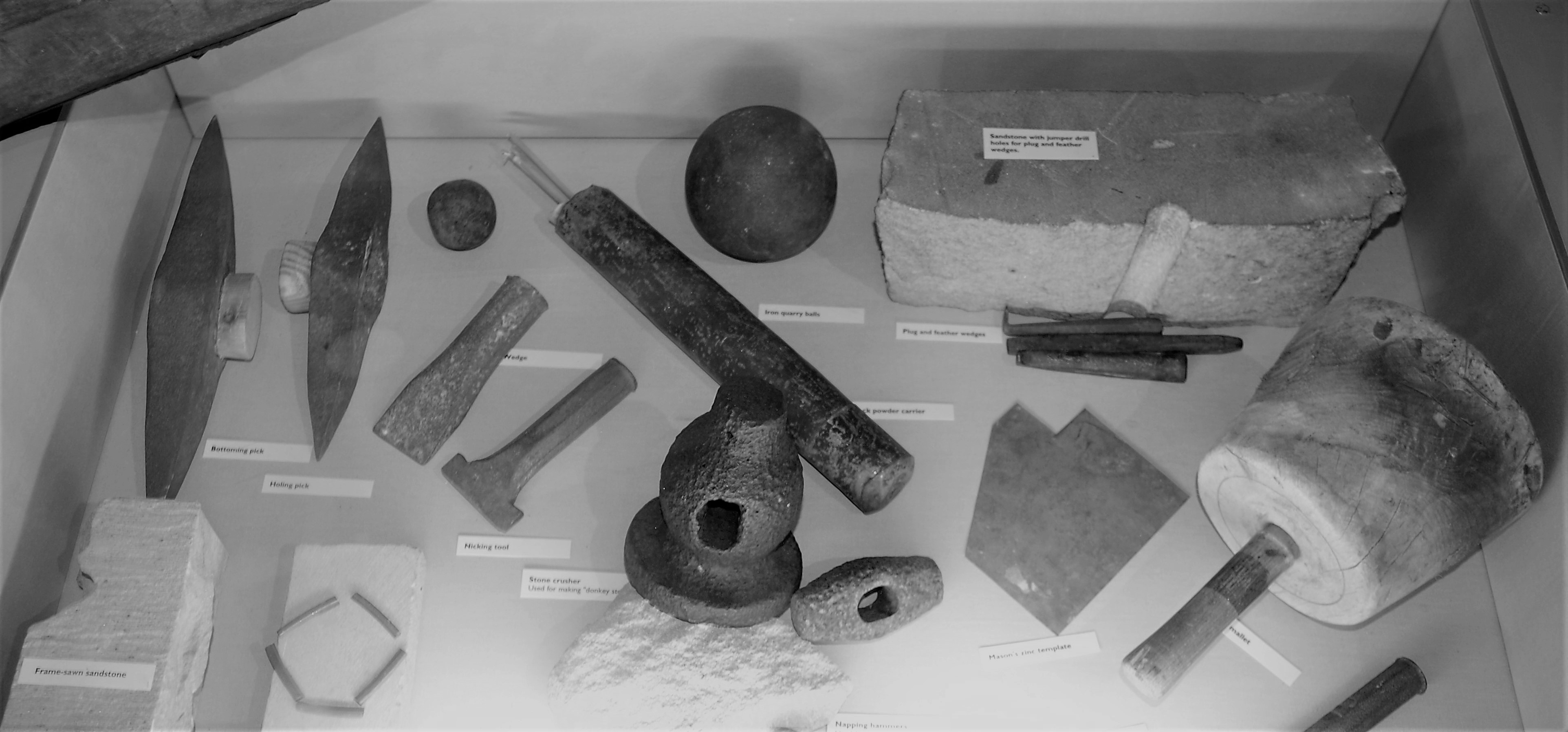
Stone-working tools from the permanent collection of
Cliffe Castle Museum, Keighley

Quarry work was skilled and dangerous. Dimension stone was split away from the quarry edge with hammers, chisels and wedges. It would be roughly dressed on the quarry floor. With luck the quarry operator would equip his site with cranes or a tramway to carry the stone on to an adjacent working area. If not strong men would carry stone up a ramp on their backs, supported by two workmates, health and safety regulations being a relatively new development. Newly quarried sandstone is soft and, even before the introduction of steam power, could be cut with saws using sand as an abrasive and water as a coolant. Unusually in this area very valuable stone deposits were sometimes mined as well as quarried.

04 Image D

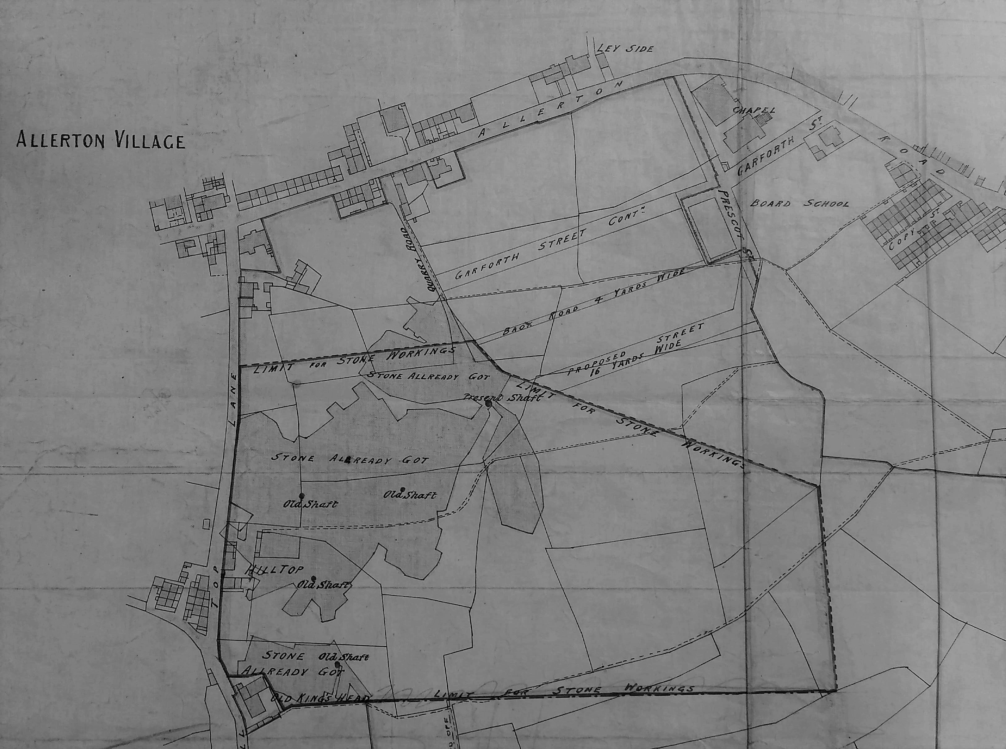
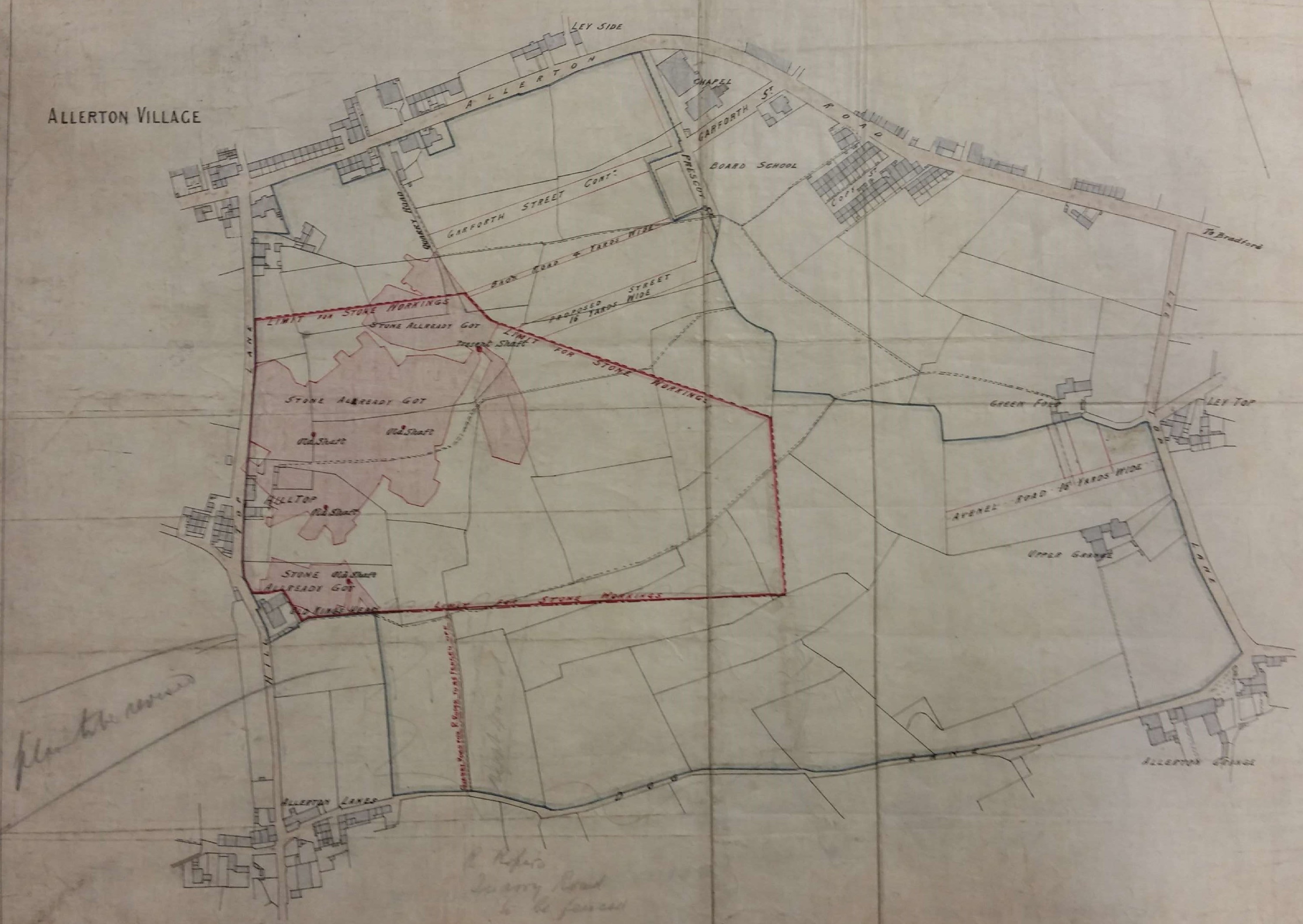
Plan of a stone extraction site in Allerton showing working and ‘old’ shafts

If you want to explore local industries further the gallery devoted to these at Cliffe Castle Museum is an excellent place to begin. For further reading about quarrying I would suggest:

J.V. Stephens et al., Geology of the country between Bradford and Skipton, HMSO, 1953. This is essential reading for geological background to any extractive industry.

David Johnson, Quarrying in the Yorkshire Pennines: an illustrated history, Amberley Publishing, 2016. Bradford is mentioned several times in this comprehensive, engaging, and beautifully illustrated book.

A most informative atlas of West & South Yorkshire Building Stones can be downloaded from the site of the British Geological Survey:

https://www.bgs.ac.uk/downloads/start.cfm?id=2509

Derek Barker, Local Studies Library Volunteer

Map of the Week: Eccleshill – coal, iron, and waving wheat.

The ancient township of Eccleshill is well represented in the Local Studies Library reserve map collection, although many of the maps are in poor condition. The following images are details which I have enhanced to make them more visible. It is hard to believe today but the whole of Eccleshill was once mined for coal, with mining features commonly being seen on nineteenth century maps of the district. The seams that could be accessed included the Hard and Soft Beds (sometimes called the Upper and Lower Beds) which were widely exploited all over the north Bradford area. Above these in the geological sequence was the important vein of sandstone called the Elland Flags, which was extensively quarried. The well-known George Vint, with his various partners, owned quarries in nearby Idle extracting this valuable rock. Modern geology maps suggest that the centre of Eccleshill was high enough to include the Better Bed coal and fire-clay seams, positioned above the Elland Flags. The Better Bed was also extensively mined as coking coal in south Bradford for the iron-smelting industry at Bowling and Low Moor. William Cudworth, in his account of Eccleshill, mentions the Better Bed, and also an associated fire-clay and brick making industry based at Manor Potteries in Eccleshill.

Ecc1

Click on map to enlarge

The first map shows the township field names with buildings and the names of their occupiers. At the bottom right is Eccleshill Hall built in 1713 and the home of the Stanhope (later Stott-Stanhope) family. As far as I know Lt.-Col. George Stott-Stanhope was the last family member to actually live there. He was a large landowner whose name frequently appears in local maps. He died in 1874 and the hall was demolished in 1878. Slightly to the left you should be able to make out the name J.A. Jowett. This was James Atkinson-Jowett (1817-1886) of the Clockhouse Estate, Manningham. The Clockhouse name survives as one of the Bradford Boys’ Grammar School buildings. James Atkinson-Jowett was the son of Nathan Atkinson-Jowett. Both men changed their surname from plain Atkinson in the 1860s in order to claim the large Jowett property inheritance. The field names are not likely to be easily visible but include: Windmill Field and Tenter Croft. A tenter croft, or ground, was an area used for drying newly woven woollens after fulling. The wet cloth was attached to frames called tenters by means of, naturally, tenter-hooks. Town Street, today called Victoria Road, divides at Bank Top into Norman Lane and Eccleshill Bank, named the ‘Old Turnpike Road’ in early maps. This division is very helpful in orientation, with portions of Eccleshill Bank being included in all the maps included here.

The second, rather clearer, map enables us to examine the northern part of Eccleshill. It is obvious that a planned street grid has been superimposed on an older map but I do not think that all those roads were actually constructed. On the right side of the map a railway line has appeared. The Eccleshill & Idle Railway was incorporated in 1866 and was assimilated into the GNR Laisterdyke to Shipley line. Eccleshill Station was closed to passengers in 1931. A land-owner whose name appears approximately in the centre of the map is described as the ‘late John Mitchell’. Eccleshill historian Ken Kenzie told me that John or Jonathan Mitchell was a coal merchant who once lived at Eccleshill Bank. He was clearly a big man in Eccleshill mining and, among others, ran Park Pits which were sold off in 1860 when he was in his 70s. On the map above his surname you may be able to make out the location of ‘Eccleshill Worsted Mill Company’ and above this, and to the left, ‘Engine Pit’. The enterprises of John Mitchell are well represented in the Local Studies map collection.

ecc2

Click on map to enlarge

The third image is taken from a plan dated 1847 and described as ‘coals leased to Mr John Mitchell, surveyed by Ingle & Smith’. Once again you can see Eccleshill Bank and the fine line grid above it represents underground mine galleries. I presume these were entered from the Engine Pit shaft. Elsewhere the map reveals extensive coal mining to the south-west of the township.

ecc3

Click on map to enlarge

The final map is the oldest and most damaged. In one area I can identify George Baron as a landowner. George Baron, of Drewton in the Wolds, was an earlier possessor of the Clockhouse Estate than the Atkinson-Jowetts. He inherited the estate from Sarah, last of the original Jowett family, and died in 1854. The West Yorkshire Archives (Bradford) has a huge collection of Jowett family documents (10D76/3/190). In box 6 of these is a lease dated 1842: ‘George Baron to John Mitchell, Eccleshill’. This document is a 28 year lease of Upper Bed and Lower Bed coals in the area of Greengates, Eccleshill. The price seems to be £60 per acre. This is somewhat north of the area discussed so far, but Greengates and Apperley Bridge were traditionally considered to be part of Eccleshill.


ecc4

Click on map to enlarge

The short horizontal trackway at the top of the last map is called Green Lane. It joins a bridleway which is now Carr Bottom Lane. We have moved west since the curved roadway at the top left, marked Otley, is the far end of Eccleshill Bank where it joins the Dudley Hill & Killinghall turnpike. A number of coal shafts are present on the first OS map of the area (which is of approximately the same date) together with a limekiln at the end of the short track leading to Wheat Close. I’m not sure if these are drawn here or not since the script is so hard to read. What fascinates me about this map are the field names themselves. At the bottom right you may be able to make out Wheat Close and, below this, Cinder Hills. Today it is hard to imagine ripe wheat being harvested in Eccleshill although we have already mentioned Windmill Field which suggests subsequent grain processing. Cinder Hills is a name normally associated with heaps of iron-making slag. Pre-Industrial iron making has been suggested in other townships which now form part of Bradford: Harden, Baildon and Bierley for example. Faull & Moorhouse (West Yorkshire Survey to AD 1500) speculated that Eccleshill should join this list on the basis of two areas called ‘Cinderhills’ in old township maps.


Derek Barker, Local Studies Library Volunteer

Map of the Week: Allerton Stone Extraction

The minerals exploited within Bradford were ironstone, coal, fireclay and sandstone. At one time there was also a small lime industry, in Bingley and elsewhere, based on the excavation of glacial limestone deposits brought by the ice from the Dales. After the Shipley to Skipton section of the Leeds-Liverpool canal was opened in 1774 there was a more direct means of access to the Skipton limestone quarries.  Ice movements would presumably have left substantial quantities of hard stone on the surface. This would need to be removed before ploughing in any case, but in regions where drystone walls were the traditional field boundaries there must have been a ready use for such material. Elsewhere resistant outcrops of rock protruded through the top soil from which potential wall stone could be removed with a hammer or crow bar. On some common land, or waste, local people may have had the right to remove such surface stone deposits. In Northcliffe Wood in Shipley there are a number of undated shallow excavations by means of which a band of sandstone called Stanningley Rock was accessed.

In many parts of Yorkshire it would have been possible to rob a Roman fort or the ruin of a dissolved monastery to obtain building stone, but not here.  In Bradford ‘delvers’ could obtain a good quality, honey coloured, sandstone. Quarrying is thought to have begun in this area in the seventeenth century and continued until the twentieth. The need for stone was perhaps greatest in the period 1860-1900 although the walls of many stone buildings in that era would have had an inner skin made from locally produced brick, which was cheaper. Stone winning processes are illustrated in these two plans of Allerton from the LSL’s reserve map collection.

The first plan is of Allerton Grange Quarry. The dated workings are from 1875-76. Towards the bottom of the plan you can see an extraction track. On the full map the track leads to Grange Lane. This name has been crossed out and ‘Dog Lane’ substituted in pencil. Dog Lane it remained until the post-war housing development of the area. The quarry seems to be marked as Upper Grange in the second OS map of the area (surveyed 1891). In 1905 a cricket pavilion was sitting on the site but by the 1930s it was fields again.

map-of-the-week-012a

The second plan shows an area south of Allerton village & Allerton Road, east of Hill Top Lane and north of Dog Lane. An extensive area of stone exploitation is indicated which not present on the first or second OS maps, but is present on the 1908 map. This plan was drawn by J Hindle, a well-known Bradford surveyor in partnership at various times with Charles Gott and Thomas Dixon. It is undated but is probably from the last decade of the nineteenth century. The important feature is that this is a stone mine, not a quarry. You may just be able to make out four ‘old shafts’ and a single ‘present shaft’. The pink areas represent stone already won or ‘got’, and evidently the land-owner has imposed a strict boundary to the exploitation. Good stone was not infrequently mined. Recently I was shown round some old mining sites in Shropshire where limestone was obtained in this way.

map-of-the-week-012b

What rock was exploited in Allerton? The local geological guides record Elland Flags being mined there. This is a sandstone stratum consisted of several bands of varying thickness and quality which were located under the Better Bed coal seam, itself extensively mined in south Bradford. The maps include no evidence of ownership although nearby Allerton Grange Farm was on Atkinson-Jowett land. Contemporary trade directories list many stone merchants situated in Allerton any of whom could have been involved with these sites.

Derek Barker, Local Studies Library Volunteer