Map of the Week: Allerton Stone Extraction

The minerals exploited within Bradford were ironstone, coal, fireclay and sandstone. At one time there was also a small lime industry, in Bingley and elsewhere, based on the excavation of glacial limestone deposits brought by the ice from the Dales. After the Shipley to Skipton section of the Leeds-Liverpool canal was opened in 1774 there was a more direct means of access to the Skipton limestone quarries.  Ice movements would presumably have left substantial quantities of hard stone on the surface. This would need to be removed before ploughing in any case, but in regions where drystone walls were the traditional field boundaries there must have been a ready use for such material. Elsewhere resistant outcrops of rock protruded through the top soil from which potential wall stone could be removed with a hammer or crow bar. On some common land, or waste, local people may have had the right to remove such surface stone deposits. In Northcliffe Wood in Shipley there are a number of undated shallow excavations by means of which a band of sandstone called Stanningley Rock was accessed.

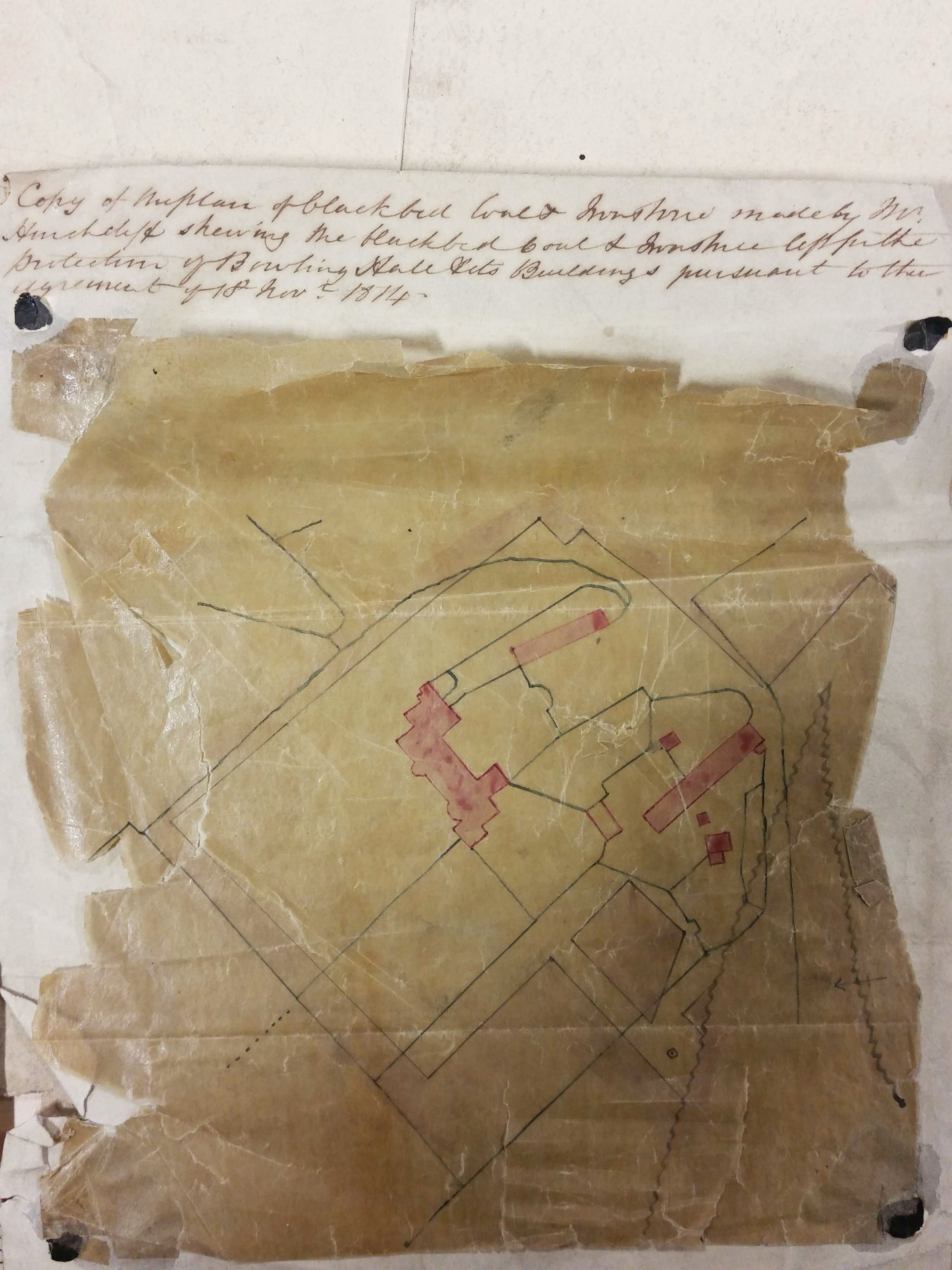
In many parts of Yorkshire it would have been possible to rob a Roman fort or the ruin of a dissolved monastery to obtain building stone, but not here.  In Bradford ‘delvers’ could obtain a good quality, honey coloured, sandstone. Quarrying is thought to have begun in this area in the seventeenth century and continued until the twentieth. The need for stone was perhaps greatest in the period 1860-1900 although the walls of many stone buildings in that era would have had an inner skin made from locally produced brick, which was cheaper. Stone winning processes are illustrated in these two plans of Allerton from the LSL’s reserve map collection.

The first plan is of Allerton Grange Quarry. The dated workings are from 1875-76. Towards the bottom of the plan you can see an extraction track. On the full map the track leads to Grange Lane. This name has been crossed out and ‘Dog Lane’ substituted in pencil. Dog Lane it remained until the post-war housing development of the area. The quarry seems to be marked as Upper Grange in the second OS map of the area (surveyed 1891). In 1905 a cricket pavilion was sitting on the site but by the 1930s it was fields again.

map-of-the-week-012a

The second plan shows an area south of Allerton village & Allerton Road, east of Hill Top Lane and north of Dog Lane. An extensive area of stone exploitation is indicated which not present on the first or second OS maps, but is present on the 1908 map. This plan was drawn by J Hindle, a well-known Bradford surveyor in partnership at various times with Charles Gott and Thomas Dixon. It is undated but is probably from the last decade of the nineteenth century. The important feature is that this is a stone mine, not a quarry. You may just be able to make out four ‘old shafts’ and a single ‘present shaft’. The pink areas represent stone already won or ‘got’, and evidently the land-owner has imposed a strict boundary to the exploitation. Good stone was not infrequently mined. Recently I was shown round some old mining sites in Shropshire where limestone was obtained in this way.

map-of-the-week-012b

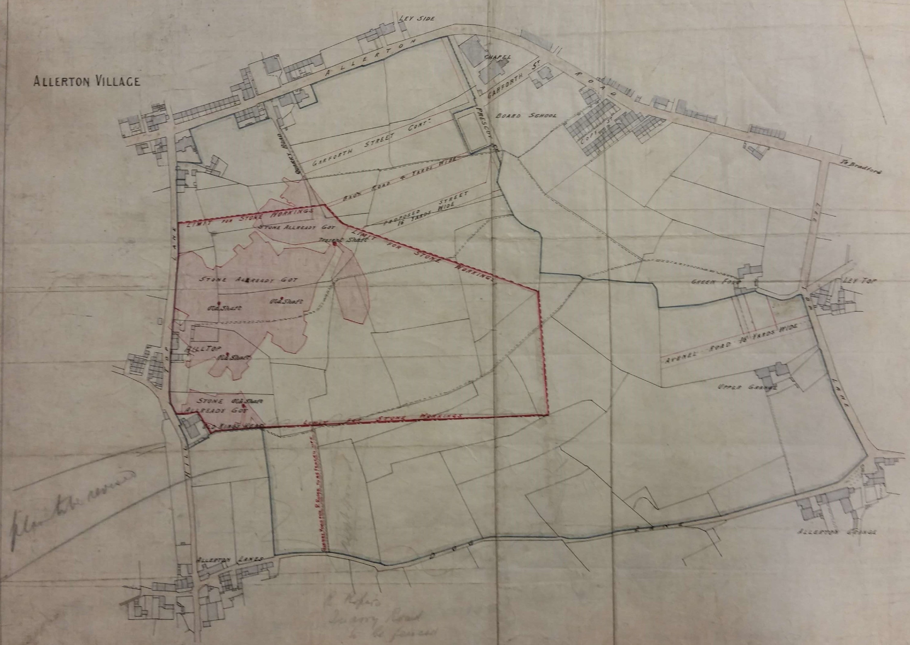
What rock was exploited in Allerton? The local geological guides record Elland Flags being mined there. This is a sandstone stratum consisted of several bands of varying thickness and quality which were located under the Better Bed coal seam, itself extensively mined in south Bradford. The maps include no evidence of ownership although nearby Allerton Grange Farm was on Atkinson-Jowett land. Contemporary trade directories list many stone merchants situated in Allerton any of whom could have been involved with these sites.

Derek Barker, Local Studies Library Volunteer

Map of the week: A Bolling Hall mineral plan

Maps and plans offer one of the best ways of reconstructing Bradford’s industrial history. Recently I found a 200 year old example at the Local Studies Library which was highly relevant to the history of the Bolling Hall estate. Victorian hand-writing is not always easy to read but, with small adjustments to spelling and capitalisation, the plan is headed: ‘Copy of the plan of Black Bed coal and ironstone made by Mr Hinchcliffe showing the Black Bed coal left for the protection of Bolling Hall and its buildings pursuant to the agreement of 18th November 1814‘.

Map of the Week 010

The fragile plan is not easy to interpret. Pink blocks represent Bolling Hall and its attendant out-buildings. Many of the black lines are property and field boundaries. Some of these make sense today, others presumably delineate parcels of land associated with the out-buildings. This whole central area is slightly paler in colour than the region outside the precinct boundary, which is darker and I assume represents winnable coal. This is most apparent if you start at the house and continue towards the bottom right of the plan. The wavy line, in an inverted V shape to the right, is probably a geological fault. In his description of the area historian William Cudworth reported a Bolling Hall fault which threw minerals ‘down 28 yards to the south’.

Bolling Hall is a Grade 1 listed building given by the last owner, Mr GA Paley, to the City of Bradford in 1912. The gift was associated with the purchase of land for nearby Bolling Girls High School, now demolished. A good deal of refurbishment has been undertaken since, including the creation of some formal gardens facing the entrance. Architecturally the hall is complex. A medieval pele tower at the south-west front contains the modern entrance and is believed to date from c1370. The south-east front Georgian bay was created in 1779-80 and (with its sash windows) contrasts sharply with the 17th century masonry present elsewhere. Historically the building is associated with two important families, the Bollings and the Tempests, but who occupied the hall at the time of this plan?

Towards the end of the 18th century the owner was Captain Sir Charles Wood, a Royal Navy officer, a painting of whom is still displayed on the main staircase. Captain Wood died of wounds in the far east and was succeeded by his son Sir Francis Lindley Wood (1771-1846). In 1794 Sir Francis gave the nearby Bowling Iron Company permission to mine coal and iron ore under his whole estate. Both as a land-owner and Lord of the Manor of Bowling Sir Francis controlled access to an immensely profitable asset. After five years he evidently grew tired of being surrounded by mines and spoil tips, however rich they made him, and he moved to another of his houses, Hemsworth Hall near Barnsley. Bolling Hall and its estate was sold outright to the BIC in 1816 and was allotted to its partners. Thomas Mason had it until 1834 then it passed to J G Paley. It remained in the possession of the Paley family until gifted to the City.

BIC had been established in 1780. It smelted iron ore found in the roof of the Black Bed coal seam, both of these minerals being mentioned in the plan rubric. A deeper coal seam, the Better Bed, made sulphur and phosphorous-free coke which was ideal for iron smelting. This seam is not mentioned on this plan, nor is the shallower Crow Coal. The removal of the Black Bed and its ironstone naturally left a gap into which the overburden of rock could collapse, resulting in surface subsidence. The common practice was to leave pillars of minerals unmined to support the roof. Under especially sensitive areas, which included churches and the mine-owner’s house, no mining at all took place. To indicate such restraint must be the purpose of this plan.

Where were the nearest coal or ironstone mines? The first OS map of Bradford (1852) shows a line of ‘old pits’ both north and south of New Hey Lane (now Road). The  Bolling Hall mine may have been closer still. About half-way between the bottom right corner of the house and the bottom right corner of the map is a small square containing a dot. I’m sure this represents a coal shaft. How deep was it? Fortunately opposite the north gate of Bowling Park (at SE 1698 3157) was a colliery called Waterloo Pit. This is only a few hundred metres away from the hall itself and fortunately the depths of coal seams at this location are recorded on the British Geological Survey website. They are:

Crow Coal            9.8m

Black Bed           28.3m

Better Bed         63.1m

The hall is at the same altitude as the Waterloo Pit (150m above ODL) so I think we can be sure that in the region of the plan the Black Bed coal was being mined, or not as the case may be, at about 30m depth.

Both the Bowling and Low Moor Iron companies exploited the same seams of coal and iron ore which extended over the whole of south Bradford and the surrounding areas. Huge networks of tramways and mineral ways grew up to bring the precious substances to the coke ovens and blast furnaces. To charge a blast furnace you also needed limestone to help the slag to separate. In the first OS map, close to the railway line at Bowling junction, is a ‘limestone quarry’. If there were limestone bedrock at this point then it would be more than a kilometre buried, so clearly we are dealing with a surface glacial deposit. The extraction of erratic limestone boulders from glacial moraine is recognised elsewhere in the Bradford district.

We are left with the problem of who was Mr Hinchcliffe? The only contemporary man of this name mentioned by William Cudworth, or present in Baines’s 1822 Directory, was Joseph Hinchcliffe who was a well-known local schoolmaster. Could surveying have been one of his skills? But the surname is a common one and could be that of an unknown BIC employee. Eventually local iron ore was exhausted and when this plan was being drawn the iron industry in Bradford had only about a century of existence left. Ore could be brought by sea from more favourable reserves abroad but transport costs ensured that only shore based blast furnaces, like those at Scunthorpe, survived. A century later still the deep-mining of coal in the UK was completely finished. This situation would have been inconceivable to Mr Hinchcliffe in 1814, whoever he was.

Derek Barker, Local Studies Library Volunteer