Map of the Week: Eccleshill – coal, iron, and waving wheat.

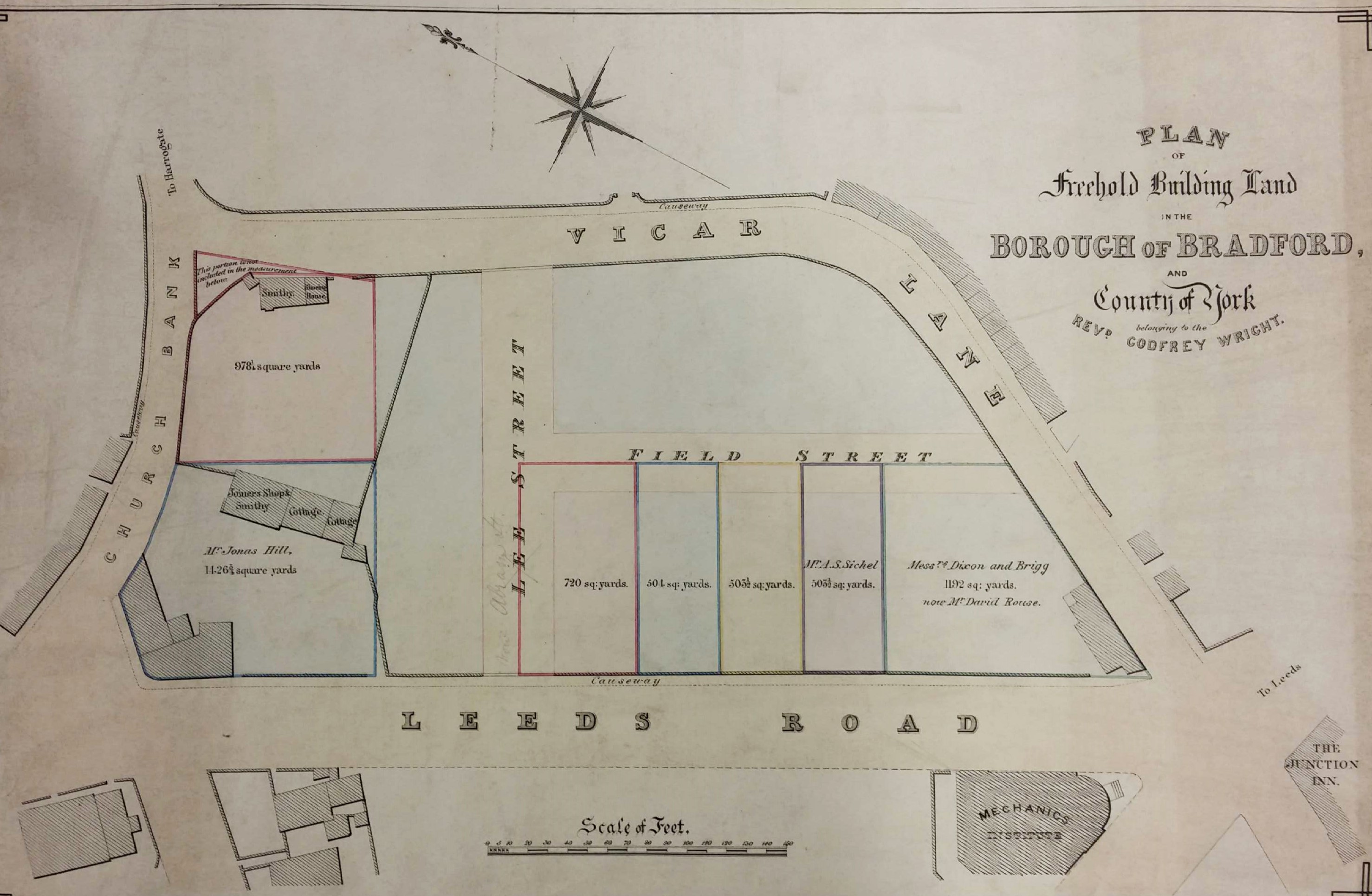
The ancient township of Eccleshill is well represented in the Local Studies Library reserve map collection, although many of the maps are in poor condition. The following images are details which I have enhanced to make them more visible. It is hard to believe today but the whole of Eccleshill was once mined for coal, with mining features commonly being seen on nineteenth century maps of the district. The seams that could be accessed included the Hard and Soft Beds (sometimes called the Upper and Lower Beds) which were widely exploited all over the north Bradford area. Above these in the geological sequence was the important vein of sandstone called the Elland Flags, which was extensively quarried. The well-known George Vint, with his various partners, owned quarries in nearby Idle extracting this valuable rock. Modern geology maps suggest that the centre of Eccleshill was high enough to include the Better Bed coal and fire-clay seams, positioned above the Elland Flags. The Better Bed was also extensively mined as coking coal in south Bradford for the iron-smelting industry at Bowling and Low Moor. William Cudworth, in his account of Eccleshill, mentions the Better Bed, and also an associated fire-clay and brick making industry based at Manor Potteries in Eccleshill.

Ecc1

Click on map to enlarge

The first map shows the township field names with buildings and the names of their occupiers. At the bottom right is Eccleshill Hall built in 1713 and the home of the Stanhope (later Stott-Stanhope) family. As far as I know Lt.-Col. George Stott-Stanhope was the last family member to actually live there. He was a large landowner whose name frequently appears in local maps. He died in 1874 and the hall was demolished in 1878. Slightly to the left you should be able to make out the name J.A. Jowett. This was James Atkinson-Jowett (1817-1886) of the Clockhouse Estate, Manningham. The Clockhouse name survives as one of the Bradford Boys’ Grammar School buildings. James Atkinson-Jowett was the son of Nathan Atkinson-Jowett. Both men changed their surname from plain Atkinson in the 1860s in order to claim the large Jowett property inheritance. The field names are not likely to be easily visible but include: Windmill Field and Tenter Croft. A tenter croft, or ground, was an area used for drying newly woven woollens after fulling. The wet cloth was attached to frames called tenters by means of, naturally, tenter-hooks. Town Street, today called Victoria Road, divides at Bank Top into Norman Lane and Eccleshill Bank, named the ‘Old Turnpike Road’ in early maps. This division is very helpful in orientation, with portions of Eccleshill Bank being included in all the maps included here.

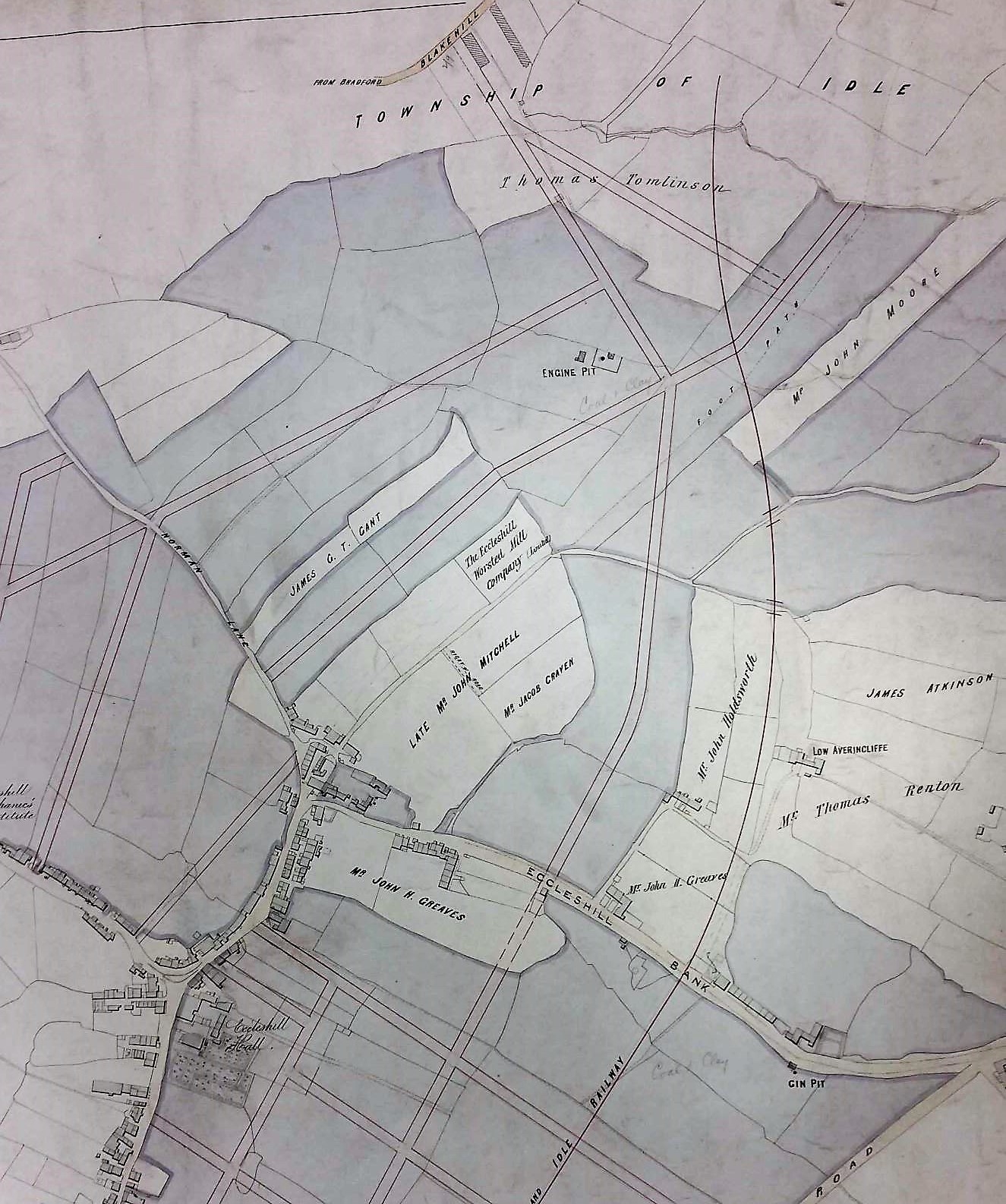
The second, rather clearer, map enables us to examine the northern part of Eccleshill. It is obvious that a planned street grid has been superimposed on an older map but I do not think that all those roads were actually constructed. On the right side of the map a railway line has appeared. The Eccleshill & Idle Railway was incorporated in 1866 and was assimilated into the GNR Laisterdyke to Shipley line. Eccleshill Station was closed to passengers in 1931. A land-owner whose name appears approximately in the centre of the map is described as the ‘late John Mitchell’. Eccleshill historian Ken Kenzie told me that John or Jonathan Mitchell was a coal merchant who once lived at Eccleshill Bank. He was clearly a big man in Eccleshill mining and, among others, ran Park Pits which were sold off in 1860 when he was in his 70s. On the map above his surname you may be able to make out the location of ‘Eccleshill Worsted Mill Company’ and above this, and to the left, ‘Engine Pit’. The enterprises of John Mitchell are well represented in the Local Studies map collection.

ecc2

Click on map to enlarge

The third image is taken from a plan dated 1847 and described as ‘coals leased to Mr John Mitchell, surveyed by Ingle & Smith’. Once again you can see Eccleshill Bank and the fine line grid above it represents underground mine galleries. I presume these were entered from the Engine Pit shaft. Elsewhere the map reveals extensive coal mining to the south-west of the township.

ecc3

Click on map to enlarge

The final map is the oldest and most damaged. In one area I can identify George Baron as a landowner. George Baron, of Drewton in the Wolds, was an earlier possessor of the Clockhouse Estate than the Atkinson-Jowetts. He inherited the estate from Sarah, last of the original Jowett family, and died in 1854. The West Yorkshire Archives (Bradford) has a huge collection of Jowett family documents (10D76/3/190). In box 6 of these is a lease dated 1842: ‘George Baron to John Mitchell, Eccleshill’. This document is a 28 year lease of Upper Bed and Lower Bed coals in the area of Greengates, Eccleshill. The price seems to be £60 per acre. This is somewhat north of the area discussed so far, but Greengates and Apperley Bridge were traditionally considered to be part of Eccleshill.


ecc4

Click on map to enlarge

The short horizontal trackway at the top of the last map is called Green Lane. It joins a bridleway which is now Carr Bottom Lane. We have moved west since the curved roadway at the top left, marked Otley, is the far end of Eccleshill Bank where it joins the Dudley Hill & Killinghall turnpike. A number of coal shafts are present on the first OS map of the area (which is of approximately the same date) together with a limekiln at the end of the short track leading to Wheat Close. I’m not sure if these are drawn here or not since the script is so hard to read. What fascinates me about this map are the field names themselves. At the bottom right you may be able to make out Wheat Close and, below this, Cinder Hills. Today it is hard to imagine ripe wheat being harvested in Eccleshill although we have already mentioned Windmill Field which suggests subsequent grain processing. Cinder Hills is a name normally associated with heaps of iron-making slag. Pre-Industrial iron making has been suggested in other townships which now form part of Bradford: Harden, Baildon and Bierley for example. Faull & Moorhouse (West Yorkshire Survey to AD 1500) speculated that Eccleshill should join this list on the basis of two areas called ‘Cinderhills’ in old township maps.


Derek Barker, Local Studies Library Volunteer

Map of the Week: Little Germany

The district known as Little Germany  is close to Bradford Cathedral. It is unquestionably one of the glories of the city being famous for a unique collection of magnificent, stone-built, Victorian textile warehouses. In many cases their original occupiers were German merchants, which provided the  name. In 1977 John S Roberts produced an invaluable short pamphlet entitled Little Germany which was my personal introduction to the history of the area. More recently Susan Duxbury-Neuman published Little Germany: a History of Bradford’s Germans (Amberley, 2015) which is full of information about the warehouses, and the merchants that owned them, with much else besides. Despite the existence of these excellent accounts I wondered if anything in the Bradford Local Studies Library reserve map collection could provide a useful additional ‘taster’.

On the 1800 map of Bradford the future Little Germany was a green field site. Fortunately two roads of that period, Church Bank and Vicar Lane (earlier Dead Lane) have retained their names, which makes the placement of the location on more modern maps relatively easy. Leeds Road, which originally formed part of the Leeds-Halifax turnpike, was created in the late 1820s or early 1830s. The Library has several plans showing portions of adjacent land. Some of these are in excellent condition but one has been subject to considerable deterioration.

The first plan here is essentially of the lower part of Little Germany. It shows the first Bradford Mechanics Institute which was founded in 1832 being aligned on Leeds Road. The plan is annotated on the back as ‘Colliers Close’. I have found no other record of this name but it is perfectly credible since coal was mined all over the city, and Roberts reports that building on some of the Little Germany sites was difficult because of old mine workings.

map-of-the-week-19a

A huge help in dating this first plan is that Bradford is referred to as a Borough, a status achieved in 1847. On the other hand the first OS map of the area, which was issued in 1851 and surveyed in the late 1840s, shows no sign of any new street development. If we said that the plan was from 1848-49 I do not suppose we should be far wrong. It is interesting to note that the area was the location of two blacksmiths and a joiner’s workshop. So in 50 eventful years the green fields of 1800 had been mined for coal, transected by a major road, and become the site of several small businesses and the first Mechanics Institute. Leeds Road on the plan, confusingly, is not the major route of that name but a short branch which was soon renamed Well Street. The name Lee Street was also soon changed, to Currer Street. There is a pencil annotation describing it as ‘Abram Street’, presumably another name that was considered. Field Street seems to have been so called originally and has retained its name. The owner of the land west of Vicar Lane, both north and south of Leeds Road, was Rev. Godfrey Wright (1780-1862). A detailed account of his life was included in the description of my previous map.

The second map is essentially the same but provides more information about the purchasers.

map-of-the-week-19b

The names recorded do not seem to be the same as those who were associated with the famous Little Germany warehouses 10-20 years later. I’m not certain if the parcels of land were sold on or whether the original purchasers simply leased the warehouses. In any case individual buildings will have had many owners and occupiers since their construction. Augustus Silvestro (AS) Sichel were a Manchester textile firm. Augustus’s son, Sylvester Emil Sichel, later lived at Shipley Grange. As early as 1856 Sichel Bros were trading in Well Street. I’m not sure what their relationship was with Victor Sichel, manager of Reiss Brothers yarn and stuff merchants in Currer Street. Victor was the father of the Bradford artist Ernest Sichel (1862-1941). Both families originated in Frankfort am Main, Germany but were they directly related? Thomas Mills was a Bradford furniture merchant and upholsterer. Thomas Fison was in the partnership of Fison & Lister, wool merchants at Well Street. Nicholas Hermann Heydemann (1817-89) was both a cloth merchant and the German Consul. He is buried at Undercliffe cemetery. In 1859 on his land at 4 Currer Street the premises of Nathan Reichenheim, yarn merchants, was constructed. This is probably the oldest of the surviving buildings. In 1874 on GB Smith’s site at the junction of Field Street and Vicar Lane was built Law Russell’s magnificent Victorian warehouse. This was constructed by Bradford contractor Archibald Neill. Both these buildings were designed by the famous Bradford partnership of Lockwood & Mawson.

The third plan is severely damaged. The section reproduced indicates that the main interest of the surveyor was surface water drainage from Burnett St, Cator St, and the upper part of Currer Street.

Map of the Week 19C.jpg

The original land-owner is not recorded but these lands to the east of Vicar Lane were part of the Vicarage Trust. I do not know if the vicar at this period, John Burnett, benefited personally from land sales but he presumably gave his name to the street. Another series of purchasers are recorded. Leopold Reiss has already been mentioned as one half of Reiss Brothers. As far as I can tell William Bollans and James Wilman were both publicans in other parts of Bradford. Eli Milnes (1830-1899) was the leading warehouse architect. He designed several of the warehouses and the fact that one carries his EM monogram suggests that he was also involved in speculative construction. Not all the land-owners are traceable. Jacob Philipp & Co. seems to have puzzled Duxbury-Neuman and certainly defeated me.  Roberts explained that most of the building occurred in the period 1860-67. The Borough Map of 1871 shows the whole area completely filled with buildings. I imagine that by 1875 the appearance of Little Germany was very much as it is today although one or two later premises were still to be constructed. Most still survive and if you are not familiar with Little Germany do please experience its delights for yourselves.


Derek Barker, Local Studies Library Volunteer