Neglected Bradford Industries: Glass making

Bradford is famous for spinning and weaving but textile production was only one of a group of important industries which ‘Worstedopolis’ supported. Since several  are now almost forgotten by contemporary citizens I should like to draw attention to those which seem unreasonably neglected in a series of short articles.

In the nineteenth century Hunslet, Rothwell & Knottingley were noted West Yorkshire glass making centres. I was very surprised to find a reference to a much more local, and earlier, source of glass production in Francis Buckley’s book Old English Glass Houses, originally written in the 1920s. The best evidence he provided was an item taken from the Leeds Mercury of 1751:

To be lett: a very good glasshouse adjoining to Wibsey Moor, three miles from Halifax and two from Bradford with a very good farm-house and 22 acres of good land belonging to it. Also eight cottages for workmen to dwell in…….There is plenty of very good stone upon the place that grinds to a good sand, and is as proper as any that can be bought to make flint and crown glass with. Also very good coal within 300 yards of this glass-house at two pence per horse load.

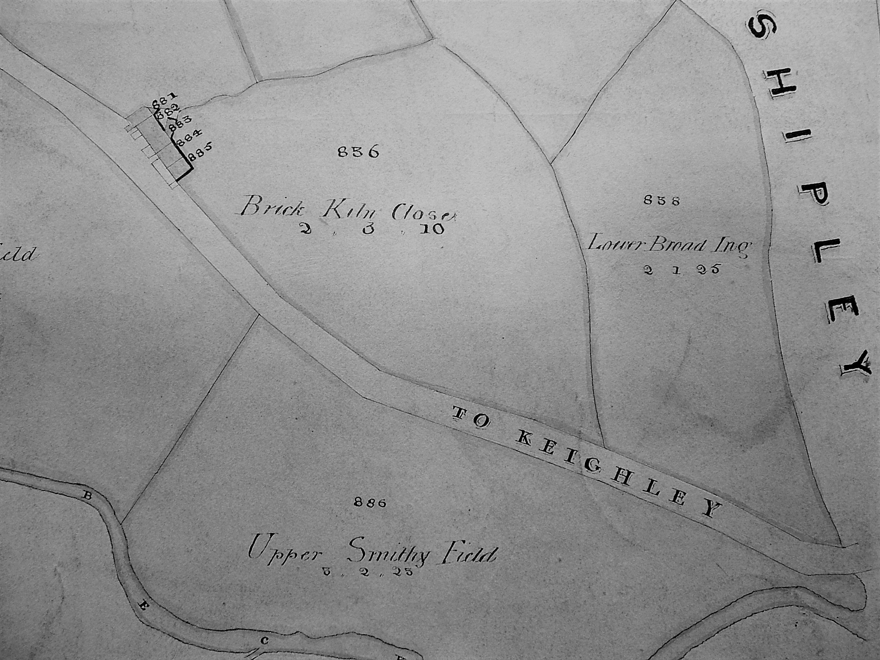
At this time Wibsey formed part of North Bierley. Places, which by the nineteenth century were called Morley Carr, Wibsey Slack, Wibsey Low Moor or Odsal Moor, could then be described simply as Wibsey Moor or Wibsey Moorside. Low Moor itself didn’t exist as a location until after the famous iron works was established.

A glasshouse, which I suppose we would now call a glass-works, included a furnace for making glass from basic ingredients at high temperature. Glass is basically fused silica obtained from the mineral quartz, for which sand is a cheap and convenient source. Silica alone can make a glass but it melts at 1700°C which is difficult to reach. Since ancient times it has known that the addition of an alkali flux, such as natron (soda ash) or plant ashes, considerably lowers the temperature of fusion to a more attainable 1100°C. To give the glass stability lime or magnesia were also incorporated. Finally substantial portions of cullet, that is scrap glass, would also be included in the mix to help the other ingredients blend together. This was achieved in a fireclay ‘glass pot’. Firclay extraction is an industry I shall discuss on another occasion.

Crown glass was used to make windows; a crown was a flat disc of glass, produced by spinning a gather of glass on a blowing iron. From a crown small panes or quarries could be cut. Flint glass was used for bottles; it did not actually include flint as a raw material. The bottles would be hand blown into a wooden mould. Usually the two type of glass-making were kept separate by law, partly for taxation reasons but also because window glass was considered to be of greatly inferior quality. At various times glass furnaces were heated by wood or coal, although furnace design differed significantly depending on which fuel was employed. By the eighteenth century, in this part of Yorkshire, the availability of cheap coal was clearly an incentive for the potential purchaser of a glass-works.

07 A CatcliffeThe glass cone at Catcliffe, South Yorkshire.

Since we know that the Wibsey Moor glass works was constructed by 1751 we can be reasonably certain about its contents and appearance. In Britain the period 1730-1830 was the era of the brick glass cones which were built to enclose a central furnace, and the space in which firms of glass makers worked. The provision of internal working space is an important distinction from pottery kilns, which glass cones superficially resemble. In the UK only four cones now survive with the nearest being at Catcliffe in South Yorkshire, considered to be the finest example in Europe.

At Wibsey Moor (Low Moor) the builder of the glass-works was Edward Rookes Leeds (1715-1788) of Royds Hall, Lord of the Manor. James Parker in Rambles from Hipperholme to Tong states that in 1780 the works were demolished by another local land-owner Richard Richardson, together with some ‘freeholders’, as an infringement of their rights. Then, he says, it was re-erected on Leeds’s own land. Disagreements over the use of common land, or the exploitation of the minerals under it, between powerful local landowners was not uncommon before the Enclosure Acts. Parker’s account is credible but he is the only source for it. Considering the advertisement from the Leeds Mercury with which I started, 1750 is a more likely date than 1780 even if the rest of the account is true. Glass House’ remained as a place name in Low Moor although the cone itself was probably demolished in the late 1820s.

07 B Fox Map
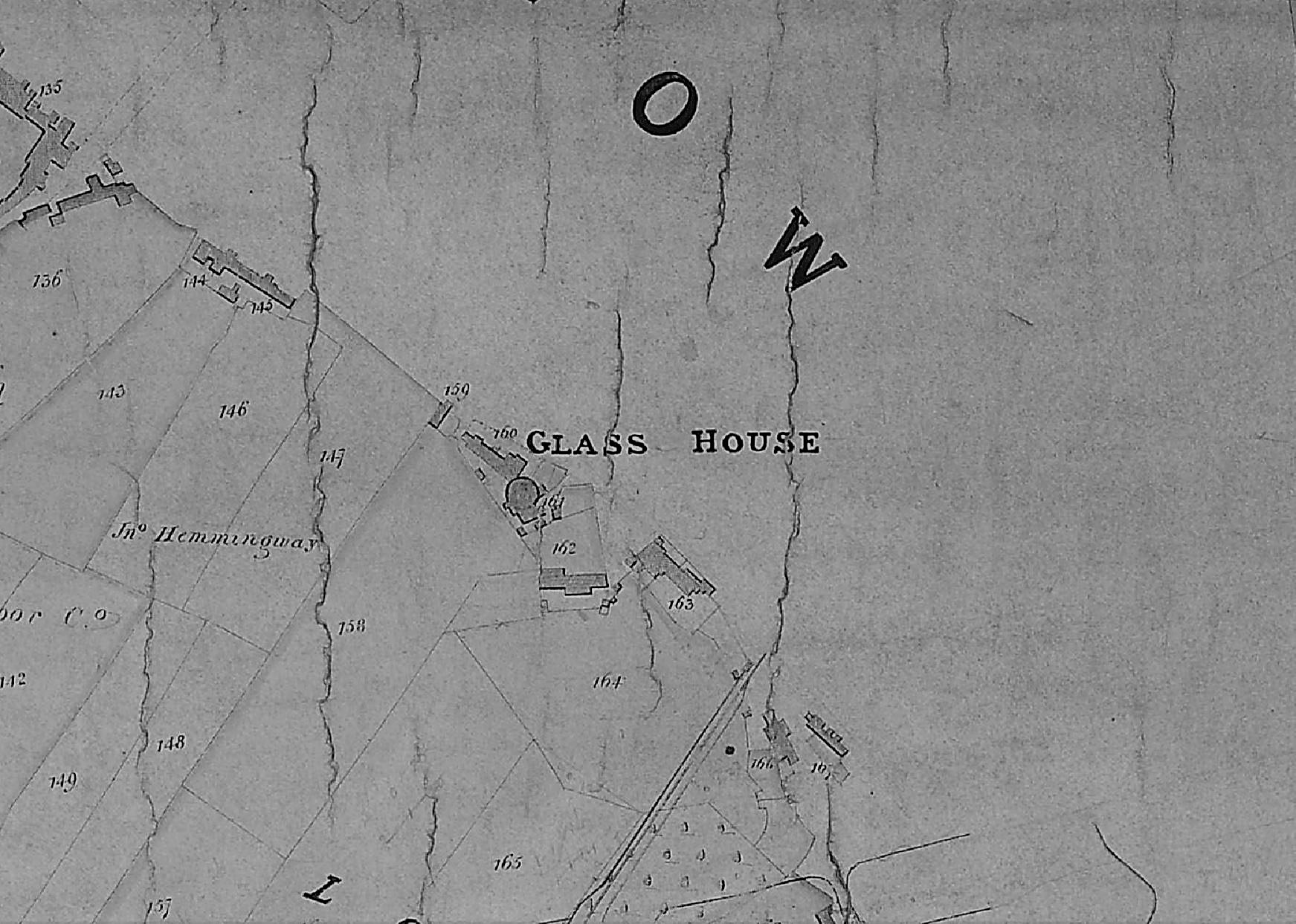
A detail of the Fox map of Low Moor showing a circular plan of the glass cone, with ancillary buildings. Other versions of this map exist in which this feature is not represented.

The ancillary buildings which seem to be represented in the plan would include storage space and an annealing furnace or lehr. A newly made glass object  needs to be cooled down to room temperature very slowly, so that stresses produced by solidification of the glass could be dissipated. This is about as far as a student of technological history can take the Wibsey Moor glass house, but I am extremely fortunate to have had the assistance of Mary Twentyman of the Low Moor Local History Group. She believes she will be able identify the original glass-maker who leased the works, and hopefully establish something about his life. The Bradford glass industry is truly forgotten and has probably received only three brief written mentions during the last 150 years. Its full story may soon be told.

Derek Barker, Local Studies Library Volunteer


Neglected Bradford Industries: Vitriol (sulphuric acid) making

I expect everyone will remember dilute sulphuric acid from school chemistry, or the contents of car batteries. In the Middle Ages alchemists made the concentrated acid, vitriol, by heating crystals of hydrated iron II sulphate (green vitriol). This is a topic I will return to when I describe copperas manufacture at Denholme in a future article. In the eighteenth century vitriol was needed for manufacturing chemicals like nitric and hydrochloric acids, and in an early industrial process for making washing soda. Hydrochloric acid was the starting point for chlorine production and the gas made was in turn used in a textile bleaching process. The synthesis of important fertilisers in the nineteenth century, like ammonium sulphate and super-phosphate, required large amounts of sulphuric acid. Some of the documents relating to a Bradford works mention ‘manures’ by which name, I assume,  the artificial fertilisers were once known.

In 1746 John Roebuck (Birmingham) had adapted a process of burning sulphur with saltpetre to form sulphur trioxide, within acid-resistant chambers made of lead. Sulphur trioxide was then dissolved in water to form the vitriol. Lead was chosen for the chambers since it was the cheapest acid-resistant metal available. These large, strong and cheap receptacles produced 35-40% acid. The chemists Gay-Lussac and Glover replaced the chambers with towers, obtaining a more concentrated product. The manufacture of some dyes, and nitrocellulose, required an even more concentrated acid which could still be produced by the dry distillation of hydrated iron II sulphate.

North Brook Vitriol Works was situated between Wharf Street and Canal Road.  Vitriol and aquafortis (nitric acid) were first made there by Benjamin Rawson (1758-1844). He is believed to have been in operation by 1792 which makes the works one of Britain’s first chemical plants. In this and much else Bradford was ahead of the game. Shortly afterwards Rawson purchased the Lordship of the Manor of Bradford, a role in which he and his two daughters, Mary and Elizabeth, will be familiar to local historians. In 1838, before Rawson’s death, the works were bought by Samuel Broadbent. He lived in Northbrook House and his garden led to the canal. Additional chemicals were now sold: spirits of salts (hydrochloric acid) and ammonia.

06 Image

Mid-nineteenth century plan showing the relationship between Northbrook House, the Vitriol Works and the Canal

Northbrook House was later used as offices and one of Samuel’s daughters married George Henry Leather, a worsted spinner. Leather took over when Samuel died and after 1844 the whole plant was known as Leather’s Chemical Works, a name which was familiar to Bradfordians within living memory. Leather also sold chloride of lime as a disinfectant, which may have been needed since the smell of the works, the canal, and nearby tipped human waste, was described in the Bradford Observer as ‘abominable’. Chloride of lime (calcium hypochlorite) was made, by exposing slaked lime to gaseous chlorine in brick built chambers. One of the most interesting documents I read in the West Yorkshire Archives when researching this subject was a memorandum of 1887 to Leather’s Chemical Works from the famous fertilizer company, Jas. Fison & Sons of Thetford. An enquiry from Leather’s revealed that Fisons were using a platinum still, presumably to concentrate and purify their sulphuric acid. The still cost £5,600 and was bought from Johnson Matthey & Co of Hatton Gardens, London. This company was brought to public notice recently by the failure of its banking subsidiary, JMB, in 1984. The parent company is heavily involved in precious metals, and chemicals, today.

Samuel’s grandson Henry Burnet took over when George Leather died in 1897. By this time a new means of making the acid, the Contact Process, was becoming widely employed. I’ve found no evidence that this was adopted in Bradford. Possibly keeping the existing plant required little capital expenditure and the decision to stick with older technology was essentially a financial one. I understand that the site was still a chemical works as late as 1970. Then it was initially sold to Occidental Petroleum but Bradford Council purchased the site a year or two later and demolished the works.

There is one small puzzle. In his book The History & Topography of Bradford John James describes a bizarre incident. About 50 years before he wrote a group of gentlemen founded a Bradford Philosophical Society. One of the members, a chemist, after many experiments discovered a way of rendering oils ‘pure and transparent’ by application of a strong acid. One of the other philosophers thought he would try cleaning the working parts of the watches and clocks of the town with the same acid. As a result all the clockwork corroded. If James was being exact the date of the trials would have been 1791. The reaction between sulphuric acid and vegetable oils is quite complex but no one could call the result transparent. The acid would attack all eighteenth century known metals except lead and gold. It does seem probable that experiments were being made with the newly available cheap vitriol but please, please, do not try these at home.

If you want to explore vitriol making further I would suggest:

AE Musson (ed), Science, technology and growth in the eighteenth century, 1971.

Documents and photographs of Leather’s Chemical Company are held by West Yorkshire Archives (Bradford): 30D90.


Derek Barker, Local Studies Library Volunteer

Neglected Bradford Industries: Brick-making

Bradford is famous for spinning and weaving but textile production was only one of a group of important industries which ‘Worstedopolis’ supported. Since several  are now almost forgotten by contemporary citizens I should like to draw attention to those which seem unreasonably neglected, in a series of short articles.

Together bricks, tiles and terracotta form the ‘ceramic building materials’. This technology was introduced into Britain twice; firstly by the Romans and secondly from the Low Countries in the Middle Ages. The ruined Augustinian priory of St Botolph, Colchester (1100-1150) is a Norman building built of flint rubble and recycled Roman brick. Brick use was insignificant until the fifteenth or early sixteenth centuries when magnificent work appeared at Tattersall Castle, Lincs (1440-1450), Framlingham Castle, Suffolk (soon after 1476), and Hampton Court (1515). The first West Yorkshire brick building is believed to be Temple Newsam House, Leeds (1640-60s). The earliest Bradford brick-maker I have been told about features in the Eccleshill parish records of 1714. Later, in 1718, John Stanhope of Eccleshill wanted to build a new hall and so reached an agreement with John Brown of Nottingham who promised to ‘dig and throw sufficient clay to make 100,000 good stock bricks’. The bricks were large by modern standards, being 10 inches long, 5 inches broad, and 2.5 inches thick when burned.

Hand-moulded bricks were formed by a maker throwing a clay and water mix, of the correct plasticity, into a wooden mould. A skilled maker with a lad could produce a thousand or more bricks daily. Newly moulded green bricks were dried slowly in a hack, or shelter, and could then be successfully fired in a free-standing heap or clamp. Constructing a true kiln needed more expenditure but the firing was more controllable, resulting in a better product and fewer waste bricks. Hand-made bricks survived the spread of the latter mechanical brick presses since their manufacture required little capital. Such bricks are still available today for conservation projects.

05 Image A

Brick-kiln close, Frizinghall. Field names with brick related elements, or buildings known as Red Hall or House, are common indicators of early brick production and use.

Local historian Tony Woods has studied the Rosse Archive records now in Ireland. He can demonstrate that Heaton coal pits were supplying a brick kiln as long ago as 1776. The field name recorded on the above map from the Local Studies Library collection confirms that there was one such kiln quite close to Heaton village, but there may have been others.  A study of early Bradford maps suggests that brick fields preceded established brick works. Evidence from elsewhere suggests that the alluvial clay in such fields was leased by owners to itinerant brick-makers who dug it and prepared it for firing into hand-moulded unmarked, or plain, bricks. There is evidence that there were such undertakings at: Fagley Lane, Bowling Back Lane, Low Moor, Frizinghall, Manningham, Leeds Road, Manchester Road, Bolton, Undercliffe, Shipley, Eccleshill and Wilsden.

05 Image B

Machine pressed bricks on display at Cliffe Castle Museum, Keighley. Note the [BB&T Co Lim] marked brick at the bottom left.

By the mid-nineteenth century engineers were experimenting with ways of forming bricks mechanically. Common household bricks produced by machine pressing started to appear after 1860, and by the last decades of the century mechanical presses came to dominate production. There were small hand-operated brick presses and large steam powered machines of various patterns. Their use avoided the need to employ skilled brick-makers at a time when the demand for bricks was rapidly increasing. The new machines also produced a uniform product much loved by Victorian architects. In the Bradford area mudstones from the Coal Measures were quarried or mined, and then ground up, to supply the brick presses. The coal seams themselves provided the fuel for firing the bricks. Machine pressed bricks frequently have a depression, or frog, for receiving mortar and may be marked with the manufacturer’s name or initials. Such marks could be stamped into the brick but alternatively brass or iron plates were inserted into the brick moulds. The heads of screws that held these plates in place may also be visible in the fired brick. The interest of those of us involved with bricks was often first captured by finding a marked brick and speculating about its origin.

05 Image C

A detail from the drawing accompanying William Cudworth’s Worstedopolis. In the centre is the Hoffman kiln at Daniel Riddiough’s Airedale Road brick works.

New patterns of kiln were adopted. Circular Beehive kilns were popular for single firings. Circular or oval Hoffman kilns were kept continuously alight. Kiln gases, on their way to the chimney, were used to dry green bricks. Hoffman kilns were very economical of fuel but needed a skilled workforce. The Bradford 1856 directory records several local manufacturers: James Fairbank, an important coal merchant and brick maker, was established at the Brick Lane colliery and was ‘sinking for coal’ near the bottom of Whetley Lane. Edward Gittins had arrived from Leicester and was advertising his new patent-brick works at the junction of Wakefield Road and New Hey Road. George Stelling Hogg had come from Leeds and had established the first of his three brick making enterprises in Shipley. George Heaton had leased land from the Earl of Rosse to dig coal and make bricks at the Shipley end of Heaton Woods. As late as the 1881 census  I can only identify 204 people in the Bradford area who gave a brick related occupation to the enumerators. This number is dwarfed by coal and ironstone miners, quarrymen, and textile workers.

Research suggests that at one time or another Bradford, Shipley, Bingley and Keighley had more than 60 brick production centres, not of course all working simultaneously, together with additional imports from Halifax, Leeds and Wakefield. At first bricks were used close to the site of manufacture to minimise transport costs. Consequently the few wholly brick houses in Bradford older than a century are likely to be constructed of locally made material. Most readers will be familiar with Bradford’s stone buildings and will naturally ask the question ‘where have all the bricks gone?’  Flues from domestic fires were normally constructed of them, and many Victorian stone buildings will have an inner skin of cheaper brick with stone facings on the visible areas. When you consider the use of bricks employed for Lancashire pattern factory chimneys, or for railway bridge or tunnel linings, the number of producers does not seem excessive. In the long run the railway spelled the end for local suppliers in favour of larger, cheaper, brick producers in Peterborough or Staffordshire.

05 Image D

Trade directories are a useful source of information about the brick industry. Advertisements were common.

A popular local house-brick was produced by the Bradford Brick & Tile Company and its most common mark is [BB&T Co Lim].  This company was incorporated in January 1868. The first directors were Halifax businessmen, with the exception of Israel Thornton of East Parade, Bradford (a contractor with his fingers in many pies). At various times it operated a number of kilns: Wapping Road, Whetley Lane and Beldon Rd, Great Horton. By 1901 the Bradford Brick and Tile Company address was simply Knowsley Street, Leeds Road which seems to have been its final enterprise.

If you want to explore brick-making further I would suggest:

D J Barker, Bradford Brick-making: the mud, the men and the mysteries, Bradford Antiquary, (2010) 3rd series 14, 66-77.

The West Yorkshire Archives (Bradford) have more information on the Bradford Brick & Tile Company (10D76/3/113 Box 5). The Local Studies Library collection of trade directories are also an important source of information.

Derek Barker, Local Studies Library Volunteer


Neglected Bradford Industries: Stone Quarrying

Bradford is famous for spinning and weaving but textile production was only one of a group of important industries which ‘Worstedopolis’ supported. Since several  are now almost forgotten by contemporary citizens I should like to draw attention to those which seem unreasonably neglected in a series of short articles.

It is the extent, rather than the existence, of Bradford’s stone quarrying industry that has tended to pass out of memory. Bradford sits on a series of Carboniferous period sedimentary rocks called the Lower Coal Measures. This series contains strata of commercially valuable fine grained sandstone such as the well-known Elland Flags. Beneath the Coal Measures is the Millstone Grit series which also provided building stone. Saltaire, for example, is constructed of gritstone. There is no essential difference between these two series of rocks, no unconformity as geologists would put it, and their junction is defined by a particular fossil species. Millstone Grit outcrops to the west and north of the city, forming the scenery of Shipley Glen and Ilkley Moor. The Aire Valley glacier once carved its way deeply into the Millstone Grit making it possible for this rock also to be exploited quite near Bradford. Sandstones and gritstones are largely composed of cemented grains of the hard mineral quartz. Ultimately these grains were derived from weathering igneous rocks and transported here, and deposited, by a vast river delta more than 300 million years ago.

Although stone was principally a construction material it did have other uses, dressed gritstone was once employed for the millstones in corn mills for example. Midgeley Wood at Baildon Green is said to show evidence of this industry, and I should be grateful if any reader could confirm this. Stone could also be crushed for gravel and sand. Any stone occurring in thick beds, which can be cut freely in any direction, is called freestone. Once hewn for facing it is known as ashlar. Gritstone and ragstone are sandstones with coarse, angular, grains that cut with a ragged fracture. Flagstones are thin bedded sandstones ideal for flooring and roofing. When this material is used on a roof it is often referred to as ‘stone slate’ although it is not true slate which is a metamorphic rock. There are plenty of true slate roofs in Bradford of course but slate came by rail, after the mid-nineteenth century, from Wales or, to a lesser extent, the Lake District. The colour of sandstone reflects its iron content. Local stone was often grey when first quarried but it oxidises, on exposure to air, producing a beautiful honey colour. Old quarries are a significant landscape feature in many parts of the Bradford area, and are commonly seen in tithe maps and the first OS maps. Many were subsequently used for land fill, recreational space, or development.

04 Image A

Quarries on Idle Moor in a detail from the first OS map of the area
(surveyed in late 1840s)

In the Middle Ages stone building was confined to high status structures: castles, churches, bridges, and great houses. The only medieval stone buildings now standing in Bradford would seem to be the tower of Bolling Hall and the Cathedral. There must have been a medieval stone quarry in Bradford since the recent Sunbridge Wells development exposed several prison cells, the rear walls of which are portions of a quarry face. Medieval vernacular architecture was in timber, thatch, wattle and daub. The construction of a large timber-framed house required carpentry of a very high order so I cannot think of timber construction as a second best to masonry. After the medieval period there was a ‘great rebuilding’ in brick and stone which in northern Britain occurred quite late, from the mid-seventeenth to early eighteenth century. Was this simply fashion, or an appreciation of the damage fire could do to a wooden urban area? As with many innovations the wealthy were the first to adopt the change. Paper Hall in Bradford is an early example in the city, and East Riddlesden Hall is a seventeenth century millstone grit construction. By the time of the 1800 Bradford map no quarries are marked and the industry has evidently moved to the surrounding high ground.

Since Bradford is famous for its stone buildings it is reasonable to ask how such large quantities were obtained. In some areas, York being an excellent example, cut stone could be recycled from Roman buildings or dissolved abbeys (after the 1540s), but not here. Before the creation of quarries there must have been large quantities of surface stone available which had been originally transported by glacial ice. In an area I know well, Northcliffe Wood in Shipley, large glacial erratic millstone grit boulders are still on the surface, and there are also several large, shallow, surface depressions interpreted as sites from which suitable stone was simply levered up. Stone that was not of sufficient quality for masonry could still be used in drystone walls of which there were vast numbers. It appears that the old quarrymen believed that the presence of a fossil weakened the stone. Rocks containing fossils were not used for ashlar but tended to end up with the wall stone. On some common land, or wastes, local people may have had the right to remove (but not necessarily sell) such surface stone deposits. True quarrying is thought to have begun locally in the seventeenth century and continued until the twentieth. Small quarries would have had a single face for stone extraction; later and larger enterprises had a staggered series of faces, known as ‘bench working’.

04 Image B

A stone quarry illustrated in a detail of the drawing of Bradford which accompanied William Cudworth’s ‘Worstedopolis’ (top right)

The image shows a nineteenth century quarry. Its edge, and the simple derricks used for lifting stone, are easily visible. In the centre is a brick works, a subject to which we will soon return. Many West Yorkshire stones have locality or descriptive names. Bradford quarries accessed Rough Rock (Baildon & Shipley), Stanningley Rock (Northcliffe), Gaisby Rock (Bolton Woods & Spinkwell), and Elland Flags (Thornton, Heaton, Chellow, and Idle). Quarries or delphs could also be dug for special projects like the creation of canals or reservoir dams. There is a small quarry next to the canal at Hirst Wood, Shipley that presumably had this function. At first stone was used near to the site of extraction to minimise transport costs, so most stone houses older than about 150 years will be constructed of very local material. As transport improved there were  significant exports. Elland Flags were once widely used for paving slabs in London. Wakefield and Manchester Town Halls were constructed of stone from Spinkwell Quarry, which the architects believed would resist air pollution well. How extensive was the industry? In 1875 William Cudworth knew of 36 stone quarries in Allerton alone, and a further 17 on Rosse land in Shipley and Heaton. Heaton still has its Quarry Hill, Quarry Street and, until recently, The Delvers public house.


04 Image C

Stone-working tools from the permanent collection of
Cliffe Castle Museum, Keighley

Quarry work was skilled and dangerous. Dimension stone was split away from the quarry edge with hammers, chisels and wedges. It would be roughly dressed on the quarry floor. With luck the quarry operator would equip his site with cranes or a tramway to carry the stone on to an adjacent working area. If not strong men would carry stone up a ramp on their backs, supported by two workmates, health and safety regulations being a relatively new development. Newly quarried sandstone is soft and, even before the introduction of steam power, could be cut with saws using sand as an abrasive and water as a coolant. Unusually in this area very valuable stone deposits were sometimes mined as well as quarried.

04 Image D

Plan of a stone extraction site in Allerton showing working and ‘old’ shafts

If you want to explore local industries further the gallery devoted to these at Cliffe Castle Museum is an excellent place to begin. For further reading about quarrying I would suggest:

J.V. Stephens et al., Geology of the country between Bradford and Skipton, HMSO, 1953. This is essential reading for geological background to any extractive industry.

David Johnson, Quarrying in the Yorkshire Pennines: an illustrated history, Amberley Publishing, 2016. Bradford is mentioned several times in this comprehensive, engaging, and beautifully illustrated book.

A most informative atlas of West & South Yorkshire Building Stones can be downloaded from the site of the British Geological Survey:

https://www.bgs.ac.uk/downloads/start.cfm?id=2509

Derek Barker, Local Studies Library Volunteer

Map of the Week: Field House Estate

The first two plans preserve a microcosm of industrial life of the mid-nineteenth century, in an area of Bradford not previously examined in this series. The Local Studies Library reserve map collection has two versions of the Field House Estate plan and I have provided a detail from each. They identify the estate as one of the many pieces of Bradford property belonging to the Rev. Godfrey Wright, who has featured more than once in these columns.

Map of the Week 026 A

A:Iron stone workings’ 1858-1860.

Map of the Week 026 B

B: Coal deposits exploited in several years between 1850-1860.

When were the plans originally drawn up? Plan B is actually dated 1847. I  assume both were created in advance of mining to record future areas of ironstone and coal extraction. Perhaps the operator, or Godfrey Wright’s agent, was responsible for them when the minerals were accessed in the decade after 1850. Two shadowy railway lines are clearly visible on both maps. The upper is marked Great Northern Railway Co. with ‘from Bradford’ on the left and ‘to Leeds’ on the right: the Adolphus Street to Leeds Central route then. The lower line is again G.N.R. and is marked ‘from Halifax’ in very poor script on the left, and again ‘to Leeds’ on the right. I am not a railway expert but I assume the second was the Bowling Junction-Laisterdyke line (opened 1854) which must have permitted Halifax-Leeds trains to bypass Bradford. Quite large portions of the line are still visible on modern aerial photographs but the rails themselves have been taken up. The two lines come together just off the plans to the right. From the date of the maps I think we can be certain that the railway information was a late addition, but in any case you can see the railway lines are drawn across the pre-existing field boundaries.

If any reader can immediately identify the correct placement of this area in modern Bradford I shall be very impressed.  It is easier if you mentally rotate the maps by 45 degrees to the left which brings north to the top centre. The road on the left of the plans, running from eleven to five, is Bowling Back Lane. In this section, when corrected oriented north to south, Leeds Road, the Bradford-Leeds railway line and Bowling Back Lane are running roughly parallel. It was probably not a very beautiful area. Cudworth describes Bowling Back Lane as: ‘pretty well cut up with railways and cinder heaps’. It is not easy to link plan features to those on the first OS map of the area which in theory would have been surveyed at about the same time, in the late 1840s. Field House and two associated gardens are represented by the cluster of rectangles in the lower centre of map B. There’s no doubt about the written name although the ‘F’ is difficult to distinguish from the long ‘s’ of house. Field House is much smaller on the OS map. Probably there was demolition when the railway line was created.

At the bottom of map B is a carriage road off Bowling Back Lane which is labelled ‘to Birks Hall’. This road is truncated on map A. Birks Hall had existed at least since the seventeenth century when it was occupied by a member of the Richardson family. Later it belonged to Benjamin Rawson, but newspapers contemporary with the maps seem to suggest that in the mid-nineteenth century it was in multiple occupancy. Notable residents were Letitia Steadman (widow of William DD, of Horton College) who died there in 1837. In 1845-46 William Murgatroyd, who was promoting railway routes, lived there. Nothing of Birks Hall appears on our two plans, nor the associated Golden Fleece Inn. The estate was sold in 1847 and ultimately became the site of a Bradford gasworks in 1877, which remained in use until the arrival of North Sea gas. Plan C was presumably surveyed just before this happened and is from a collection at  Bradford Industrial Museum. It is on a different orientation to the first two but you will see that the left edge of the more modern plan joins the right edge of plans 1 and 2 and a good deal of housing development has taken place here.

Map of the Week 026 C

C: Site of the intended Birkshall Gasworks

The older plans show a total of three tracks leaving Bowling Back Lane or the Birks Hall road and heading north. In the centre is an access way to Field House itself. If I am correct the ‘Old Wagon Road’ was a mineral tramway used by the Bowling Iron Company. In his unpublished account Derek Pickles calls it ‘Golden Lion’ and says: ‘this line was one of the earliest put down by the Company. It ran from the (Bowling Iron) Works, across Bowling Back Lane, along the line of what is now Hammerton Street to coal staithes at the rear of the Golden Lion Hotel in Leeds Road.’  It is clear from the OS map that arches had been created on the railway embankments to allow the tramway to pass beneath them. The third track, Pit Road, as a name which is fairly common in mining areas. This one ran to New Leeds, the name applied to the development immediately south of Leeds Road. Today Birkshall Street and Hammerton Street are in approximately the position of these three tracks.

To examine the two extraction industries shown it is easiest to start on the right of the first two maps with a diamond shaped area. This is evidently underground and is accessed by shafts and galleries. Across it runs a ‘gall’ or throw, that is a geological fault. An area of unworkable material is labelled as coal in one map and stone in the other. Stone must mean ‘ironstone’ although the more common sandstone was mined, as well as quarried, in some parts of Bradford. To the left of this diamond is a much larger, roughly triangular, area of exploitation crossed by a long ‘breach’. I have seen this word before in local mine maps and I assume it represents a larger fault. Plan A shows ironstone working and plan B a much larger area for coal mining. The combination of iron  ore and coal would suggest that the famous Black Bed coal seam was being accessed but a note elsewhere on Plan B helpfully identifies ‘blackbed workings’. Modern borehole reports, from reasonably near the site, suggest that the seam is 20-30m deep. The mined products were surely sent to the premises of the Bowling Iron Company just to the south.

The mining is shown to be extensive, but not unrestricted. In the pillar and stall technique miners left columns of coal to support the gallery roof. Miners could be even more cautious. In Map A a strip along Bowling Back Lane was shown unmined ‘for support for buildings’. The fact that this is being done must indicate that the mined seam is fairly shallow. It is difficult to suggest a date for the conclusion of mining in this area. For one thing I cannot identify the colliery’s name. The first OS map shows a Birks Hall Colliery south of the track to Birks Hall itself, but this is seemingly not part the Field House Estate. Field House does not appear to show any mining activity at all on the first OS map although the 1850 Bradford map shows some ‘old pits’. One explanation would be that the activity on this ground began soon after the OS surveyors had left. The Godfrey Wright died in 1862 and it is possible than the plans were completed because of this event. Wright would never have operated the mines personally, but who did? The Jones Mercantile Directory of the following year lists over 100 coal proprietors and merchants in Bradford which indicates the extent of the industry. In the 1851 census two families live at Field House. The head of one is Abraham Rodgers, 65,  coal dealer employing 30 men. Could he be the colliery operator? I have tried to find out more about him. If he also spelled his name Abm Rogers I can also locate him 10 years later in Wortley when he is a ‘coal miner and proprietor’. Sadly he doesn’t seem to feature in any of the Trade Directories I have consulted which is an unsatisfactory conclusion to the study of these fascinating plans.

Derek Barker, Local Studies Library volunteer