Wibsey

Wibsey sits to the south-west of Bradford, at the top of one of the hills leading out of the city. The village actually stands at quite a height. Looking at an Ordnance Survey map, the 850ft contour line passes through the roundabout at the top of St Enoch’s Road and the land rises to 975ft at Beacon Hill. This must be one of the highest extensive urban areas in Britain. The population in 1991 was 5,357.

The village was mentioned in the Domesday Book as Wibetese. At that time the manor was granted to Ilbert de Lacy by William the Conqueror. The origins of the village name are still uncertain. It has been suggested that the name is an adulteration of “Wigbed’s Land” or “Wigbed’s Height”.

The manor of Wibsey at that time had a common, and the village was surrounded by the Forest of Brianscholes. This was a dense, dark place which offered cover to wild boar and even wolves. Villagers had to have their wits about them on dark nights.

The monks of Kirkstall Abbey  established the famous Wibsey horse fair. Drovers came here from all four corners of the British Isles to buy and sell horses. The fair’s heyday seems to have been at the start of the 20th century, before the start of World War One. Horses were run along Fair Road, Folly Hall Road and Reevy Road.  Additional markets selling various goods spread down Market Street, High Street and Smithy Hill, and even into the fields to the south of the village. You could buy anything from pots and pans to the famous Wibsey geese. There were also traditional fairgrounds, spectacularly lit at night. Much safer to wander around at this time than when the village was surrounded by the forest. The fair usually lasted from 5 October to 20 November. The final day was known as the ‘Ketty Fair’, on which all the horses and animals in poorest condition were sold off.

Wibsey Slack was home to the famous geese. They used to roam here quite freely and unconfined. It used to be regarded as a sign of impending bad weather if the geese left the slack and wandered into the actual village.

One of Wibsey’s most pleasant areas is its park. It is around 30 acres in size and was opened on 25 May 1885, after a grand ceremony. It has always been a popular recreational area with locals. There are sports pitches, a lake, flower gardens, children’s areas and an aviary. The park was once home to a strange attraction. In the 1930s visitors to the park were invited to relax in a ‘sitting room’ sculpted from plants and hedges. This novel arrangement was one of many sculptures produced by the first park keeper, James Walton.

Wibsey Park was built on Wibsey Slack. The area was to be enclosed by the lords of the manor in 1881, but a local councillor, Enoch Priestley, fought against this for the rights of the local people. The land was saved and the park created. Enoch Priestley became a local hero. He also campaigned for a new road linking the village to Bradford. When the road was completed Priestley was unofficially canonised by the locals. They named the road St Enoch’s in his honour.

Wibsey has had a varied industrial history. It was a popular coal mining area, though it seems the coal was of poor quality and was only mined near the surface. The Industrial Revolution arrived here in 1836 with the opening of the first mill. One of the famous characters of this time was Joseph Hinchcliffe. He ran the Horton House Academy and in 1826 started up a Sunday School in the old chapel on Chapel Fold. The school had over 100 pupils and helped boys and girls whose religious instruction would otherwise have been neglected.  Hinchcliffe carried out his teachings until ill health forced him to retire in 1834. However, no one came forward to replace him in the Sunday School, so rather than let the children down, Hinchcliffe decided to carry on teaching them from his home at Horton House. He was also a generous man. Every Christmas he treated the children to a Christmas dinner and each winter he would go round to the homes of the more needy boys and girls and instruct their parents to buy them new clothes at his expense. A true Samaritan of his day!

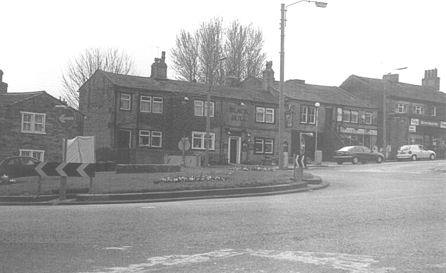
Today Wibsey is a popular commuter suburb for the city. The past seems to rub shoulders with the present here. Cobbled streets and ancient cottages still exist, many bearing the dates of when they were built. Wibsey has its modern face too. It has a thriving nightlife, based on the  pubs on the High Street, such as the Ancient Foresters, Swan and the Windmill. People travel from all over Bradford and from further afield, for a night out here. The village has all the shops and services you could wish for, mostly situated along the High Street. In fact you could live here quite comfortably without ever having to visit Bradford. This has helped Wibsey maintain a ‘village’ feel, even though it is only a few miles from the city centre.

wibhs

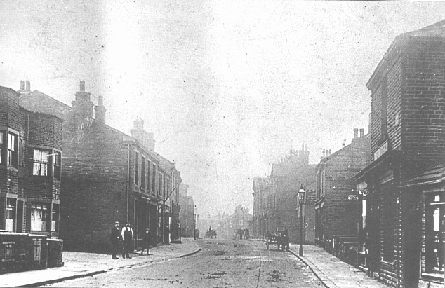
Wibsey High St. c.1900
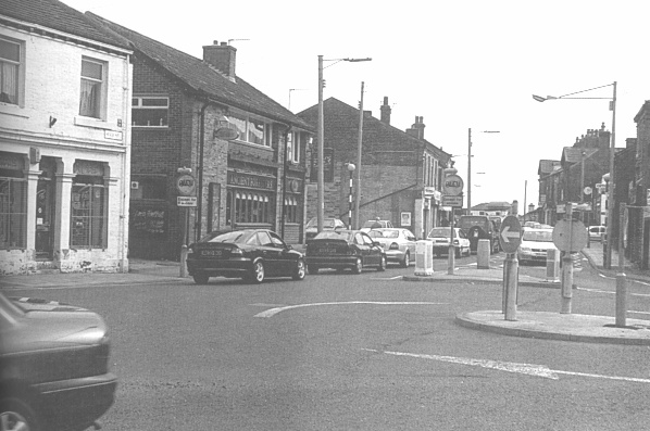
wibhs2

High St. 2002

This information was taken from “The Illustrated History of Bradford’s Suburbs“, by Birdsall, Szekely and Walker

The Bradford Territorials

On Saturday November 21st, Bradford Local Studies Library was proud to host a talk, “The Bradford Territorials” given by Tricia Platts of the Bradford World War One Group. The well attended event gave an informative insight into the Territorials, and particularly Bradford’s own Victoria Cross recipient, Samuel Meekosha.

There is a display about Samuel Meekosha in the Local Studies Library in Bradford.

20151121_111820

Clayton – An ancient settlement

Clayton was ancient settlement and was mentioned in the Domesday Book.   It was part of the Manor of Bolton, under the control of Ilbert de Lacy.   At that time it was known as ‘Claitone’, meaning ‘clay soil’.   When Clayton ceased to he part of the Manor of Bolton, it was split into three parts: Clayton Village, Clayton Heights and Cockan, a now non-existent village which lay to the southwest of the present village.

Between 1160 and 1316, Clayton belonged to the following Lords of the Manor: Hugh Stapleton, William de Stapleton, Jordan de Birill and Hugh de Leaventhorpe. It was then acquired by the Bollings in 1324. The Bolling family. and their successors the Tempests, held the Manor of Clayton for nearly 300 years, until it descended to the Lacies of Cromwell – Bottom by marriage.  After the Lacies sold the manor  around 1740, it passed through many hands until 1894, when the district council was formed. The council fought off an attempt by Bradford Corporation in 1898 to amalgamate Clayton with the city of Bradford, and for many years the villagers enjoyed their independence. Inevitably though, in 1930, Clayton finally become part of the city of Bradford, much to the reluctance of many of the residents.

Up until the end of the 19th century, Clayton was almost all green land with very few buildings indeed.  Looking at maps from 1893, it was only a very small village surrounded by fields. In the early 20th century much development took place but the village still had its green belt surrounding it.  Even today, Clayton is separated from its nearest neighbours by fields. It must be a ramblers’ paradise. One can walk to Thornton. Queensbury and even Ogden reservoir through the fields and across moors.

Prior to 1878, when the railway station opened, the only means of transport to and from the village would have been by foot or horse. The station was on the Bradford, Halifax and Keighley branch of the Great Northern Railway, and was situated on Pasture Lane. This meant that it was only 12 minutes to Bradford via rail and only 23 minutes to Halifax. Quicker than driving today it seems. The branch line Closed in 1955 and the entrance to the Queensbury Tunnel was blocked and sealed up.

The railway might have mode it easier for residents to leave the village, but there was not actually much need for this. Clayton was quite self-sufficient.  Many shops had opened in the Clayton Lane area. In 1900 there was a draper, grocers, newsagent. shoemaker, beer retailer, butcher, milliner, confectioner, builder and even a clogger.

One of the focal points of todays village is Victoria Park. The park actually originates from the old village green. In 1897, a meeting of residents was held at which it was proposed that the village green and surrounding land be purchased to form a park.  It was suggested that the park be created for Clayton residents to use forever, and donations were collected so that the project could succeed without any cost to ratepayers, although the park’s upkeep would be paid for by the rates.  The scheme was started in commemoration of the Diamond Jubilee of Queen Victoria and the park finally opened on 23 July 1898. It was opened by Asa Briggs, the highly respected Clayton philanthropist.

The roundabout in Clayton is home to the “wells”.  The wells were stone troughs which supplied water in days gone by.  Householders without water supply would bring their own buckets here to fill up, and carters on their way to Queensbury or Thornton would stop here to let their horses drink. The area was a popular meeting place in times past.

clay2 clay

One of Clayton’s biggest claims to fame is that it was the birthplace and home of Albert Pierrepoint, Britain’s last ‘Number One’ official hangman. In his role as state executioner Pierrepoint dispatched some of the country’s most notorious convicted murderers – while expressing some personal reservations about the value and use of capital punishment.

Alfred Wallis was a well-known and respected Claytonian. He started business in Oak Mills in 1860, with Asa Briggs and Joseph Benn. He was active in Clayton’s affairs for many years and he set up the Alfred Wallis Trust Fund, which can still be used today for the further education of Clayton’s young people. Another of the area’s characters was known as the ‘Clayton poet’. Sherwin Stephenson was born in the village in 1881. He became a talented poet, describing his experiences and life in Clayton. He penned such verses as; `Bonny Clayton’, `Teah Pot Spaht’, ‘The Old Brewery, Clayton’, ‘Cote Fields’ and ‘My Native Hills’, all celebrating the people and surroundings of Clayton. He even described the wells as a meeting place of the ‘Clayton Parliament’. A true ambassador for the village, Sherwin died in 1954. He is buried in Clayton churchyard, where his headstone resembles an open book.

Stephenson’s poems are a perfect reminder of how Clayton used to be. The village will never be the same again, but it is one of the few areas of Bradford which has retained its character somewhat. Stephenson would be proud.

Lister Park Lido

It is just over 100 years since the opening of the Lido in Lister Park.
It officially opened on 19th June 1915.

Opening Notice

Here is a description of the bath from the official opening programme.

DESCRIPTION OF THE SWIMMING BATH.

THE entrance to the Bath is by a forecourt connected to one of the main avenues the park.

The Bath is surrounded by a close-boarded fence, seven feet high, fixed on the top of an embankment which has been formed from the material excavated for the pond; trees are planted on the slopes of the embankment and around the Bath and next to the inner side of the fencing flower beds and shrubs have also been planted.

The Swimming Pond is 150 feet long by 60 feet wide and will hold 286,000 gallons or 1,300 tons of water. The depth is 3 ft. 4 ins. at the shallow end and 6 ft. 10 ins. at the deep end.

Settling tanks have been formed at the west end of the Bath for the purpose of intercepting the solid matter in the water from the stream by which the pond will be supplied, and the outlet of the pond will discharge into the stream.

Six separate flights of steps, giving access to the pond, are recessed in the gangways so as to avoid any obstruction to bathers.

A diving stage, at the deep end of the pond, has been erected so as to enable diving competitions to take place in accordance with the conditions which govern the English Championships and with all regulations relating to diving competitions. There is also a spring diving-board fixed to the gangway.

On three sides of the pond there is a galvanized iron handrail, and at the shallow end a sparge pipe has been fixed to be used as a spray and for cleansing the surface of the water.

Spittoons are arranged around the pond.

Life-buoys are placed in convenient positions around the pond for use in case of emergency.

Dressing boxes and sheds, to accommodate seventy persons, are arranged on each side of the bath, and the gangway is of such a width that additional dressing boxes can be erected it necessary.  There are two dressing rooms which can be used by swimming clubs or for the purposes of gala performances.

Six electric lamp standards have been fixed around the pond and two at the entrance for lighting purposes.

The main building is at the shallow end of the Bath and comprises entrance hall 11 feet wide, fitted up with two turnstiles and a collapsible gate, and on both sides of the entrance accommodation has been arranged for cycles.

Adjoining the entrance hall there is a small cafe with a projecting balcony, and from the balcony a full view of the bath can be obtained. There are balconies on each side of the cafe which can be used in connection therewith; a ladies’ retiring room is also provided as well as lavatory accommodation for men and women.

Staircases on each side of the entrance lead to the pond gangway, and from the gangway four flights of steps lead to the galleries and balconies.

The Attendant’s room is immediately under the entrance, and is placed so that the attendant has full supervision of the Bath.  The foot and shower baths are supplied with hot and cold water and adjoin the Attendant’s room.

There is seating accommodation in the galleries for 480 persons for swimming exhibitions or gala performances, and an additional 560 persons can be seated by providing chairs on the balconies.  There is also standing accommodation for 1,000 persons, and the total accommodation is 2,040.

The swimming pond has been constructed, and the water supply service arranged, under the supervision of the City Engineer and Surveyor (Mr. WHS. Dawson), and the remainder of the Bath to the designs and under the direction of the City Architect :Mr. W. Williamson, L.R.l.B.A.).

Entrance

Lister Park Lido

In the 1930’s there was a marked decline in the popularity of the bath, the reason being that it did not comply with the standards of hygiene demanded by modern swimmers. Cold and unfiltered water, inadequate dressing accommodation. etc. all contributed towards this end.

Under these conditions. it became obvious that something more up-to-date should be provided to meet the reeds of the ever-increasing number of swimming enthusiasts.

Therefore. the City Council, acting on the recommendation of the Baths Committee decided, after most careful consideration, to carry out a scheme of modernisation.

A filtration, sterilisation and heating plant has was installed, capable of treating the entire contents of the pools in a period of six hours, thus ensuring, at all times, water having a high standard of purity and maintained at a temperature of approximately 70 degrees Fahrenheit..

Surrounding the large swimming pool was a raised terrace on which sunbathers could recline, and to the rear of this were seats, arranged in tiers, for spectators, provision being made for the latter to obtain shelter during inclement weather. A spacious cafe with glass-fronted lounges was an added amenity. The new look lido was officially opened on 3rd May 1939.

In 1973 cutbacks meant the lido only opened briefly, and finally, in 1982, it was discovered repairs worth £60,000 were needed.  The baths closed in 1983 and were finally demolished in 1991.