In the 170 years since Bradford became a borough, in 1847, its centre has changed almost beyond recognition. New buildings have been erected and old ones demolished. The Bradford Beck has progressively vanished underground into culverts. New roads have been created (Sunbridge Road being a good example), while others have been repositioned, lengthened, or have disappeared entirely. Change has been a continuous process but it was accelerated in the 1960s when there was a wholesale city centre redevelopment associated with the name of SG Wardley, the City surveyor and engineer. I should like to recount something of this story by describing the events that befell a thoroughfare called Chapel Lane.
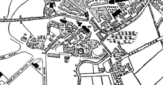
Image 1
I thought I had made a good start with the this first plan, which is widely reproduced and purports to date from 1800. Here it is easy to see the acute angle made by the Turls (Tyrrel Street) and Chapel Lane/Toad Lane. Toad Lane is an odd name but it is not unique; there are, or were, Toad Lanes in Bingley, Newark and Rochdale. Possibly the name is a corruption of ‘t’owld’ lane: certainly in Bradford the lane is drawn, but not named, on a map as early as c1722. On the above plan building (3) is the Unitarian Chapel which was certainly in existence at this time. An existing town hall is numbered (35) on the map but there is a small puzzle here. The Act of Parliament that appointed commissioners for levying rates, and improving Bradford roads and lighting, was only passed in 1805 and no town hall was to be built for decades. I am very obliged to local historian Kieran Wilkinson who explained this apparent anomaly by telling me that the map of 1800 is not contemporary but was a creation of the late nineteenth century, and marked places both where important local buildings were in 1800, and would be in the future. Let us instead look at a detail from a map that is believed to be contemporary, that of 1802, which is available in the Local Studies Library.

Image 2
I do not think that there is much doubt that the second plan was the origin of the first, but there are some difficulties here too. Firstly Toad Lane is not mentioned. Kieran tells me that the shortening of Toad Lane, to that unnamed portion that leaves Chapel Lane at a right angle to join Bowling Green, happened in August 1804. The town’s board of commissioners changed both it and the names of a number of other roads in the town (Bank Street, Bridge Street, Market Street and Well Street being introduced as names then). Secondly although there is a Chapel Lane there is no obvious chapel. In his Pen & Pencil Pictures of Old Bradford William Scruton gives a full account of this building, originally constructed in 1717. Much of its material came from Howley Hall, Batley and the land on which it stood was donated by the Sharp family of Horton Hall. The names was originally the Toad Lane Presbyterian Chapel. The old chapel lasted about 150 years and for much of this time was located ‘amid green fields’. The chapel was replaced by a larger more modern structure in 1869, and finally demolished a century later. The most notable figure to be connected with the institution was Rev. Joseph Dawson who is closely associated with the exploitation of the mineral wealth of Low Moor. One possible explanation of the difference between the two maps is that the 1800 marks the position of the 1869 rebuild whereas in 1802 the chapel formed part of the block drawn immediately south of the first section of Chapel Lane. Unfortunately this simple explanation cannot be correct. A chapel, but with no denomination provided, is mapped here c1722, which is in accordance with Scruton’s statement, and the following detail from a map of 1825, surveyed by L Atkinson, clearly illustrates the same building. Here the building numbered (8) is identified on the map rubric as the Unitarian Chapel.
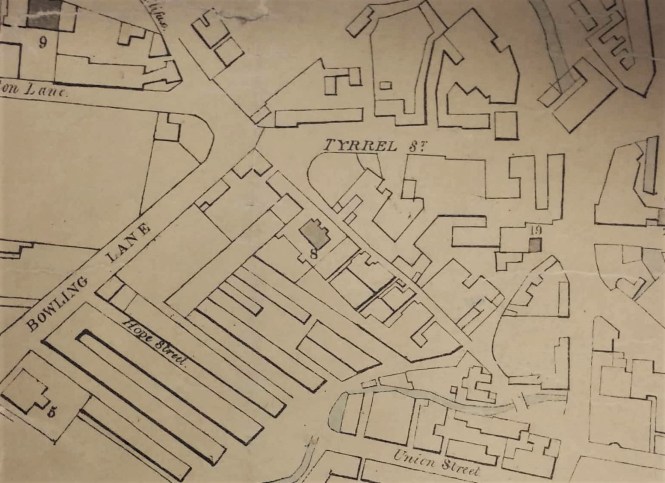
Image 3
I have already mention the Bradford commissioners. This early embryo town council are said to have originally met at the Bull’s Head Inn, Westgate. At the first meeting according to historian Horace Hird, Lord Mayor (1951-52), the commissioners drew up that list of Bradford roads. The same commissioners moved to the ‘Station House’ in Swaine Street after it was erected in 1838. They did not change landlord since the Bull’s Head and the Station House were both built on land leased from Rev. Godfrey Wright who regularly features in this articles. The final building I want to mention is the Bowling Green Hotel, which completes what I shall call ‘the central triangle’. This hotel was located at the end of Bridge Street. Cudworth mentions that in the 1830s its owner was a Mrs Susannah Ward, widow of Joseph Ward. William Scruton pushes the Bowling Green’s existence still further back into the seventeenth century. He regarded it as ‘the best inn of the town’. It was used by the Royal Mail and the open space in front of the inn, which presumably was once a bowling green, came to be employed for political meetings. The road names remain unchanged until the mid-nineteenth century, which is represented by the next map from the Local Studies Library reserve collection.

Image 4
It is perfectly clear that there has been extensive construction in the central triangle. The Bradford Observer (1844) observed that the premises of DH Smith at the corner of Toad Lane were ‘striking and elegant’. Elsewhere a ‘Smith’s Tavern and Beer-house’ is noted which I assume was the same building. Other developments were evidently far from elegant. In 1847 the Poor Law Commissioners considered Chapel Lane a possible site for a ‘vagrants yard’, and in 1855 a ton and a half of ‘vile bones’ were removed from the premises of John Boyd. The Lund’s 1856 Directory of Bradford lists John Boyd as a ‘rag dealer’. The same source gives Rev. JH Ryland as the non-resident minister at the chapel. There is also an architects’ partnership (Stott & Illingworth) and a painter (John Edwards), but otherwise the Chapel Lane residents are all tradesmen: plumbers, hair dressers, bootmakers, saddlers, pawnbrokers and so forth. Was the ‘Old Foundry’ (Cliff’s Foundry) drawn on the second map still functioning in the town centre? According to Hird it was.
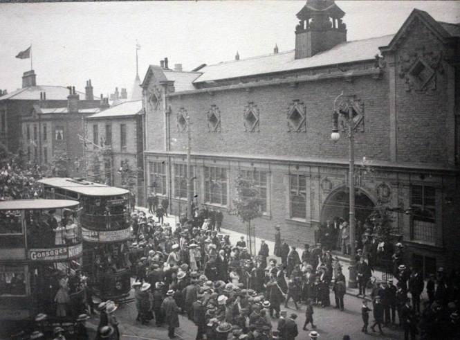
The new unnamed cut-through joining Chapel Lane and Tyrrel Street is Bower Gate. Toad Lane makes an acute angle with Norfolk Street. Kieran Wilkinson tells me that Toad Lane was ‘stopped up’ in 1869 to assist with the subsequent Town Hall development. The Bradford Daily Telegraph of 10 September 1873 recalled that Toad Lane was a ‘narrow passage… immediately behind Garth’s warehouse’. According to the Bradford Observer of 17 March 1869, the width of Toad Lane was only three and a half yards. The next development, which I have already hinted at, represented a huge change. Bradford Borough Council decided that a purpose built Town Hall was required to support the rapidly growing urban area. A number of sites were considered but Chapel Lane or the Bowling Green were the front runners. Finally a competition was launched to design a hall to be built on the Chapel Lane site. The winning design was opened by the Mayor, Matthew Thompson, in 1873. The architects were the famous partnership of Lockwood & Mawson who had already designed the Wool Exchange (1867). The contractor was John Ives of Shipley. In his book Bradford in History Horace Hird described the whole process and provided illustrations of the runners-up. It seems that all the considered designs were for Gothic buildings including a tower. The stone for the winning design came from Cliff Wood quarries but at present I do not have sources for the glass, metal work and ornamental marbles, nor the million bricks incorporated into the structure. The Unitarian Chapel and Chapel Lane itself were left alone during this development, but Bradford became a city in 1897 and the increase in council business required an extension to the Town Hall, opened in 1909. This provided more committee rooms and a banqueting hall. The designer was Richard Norman Shaw. As you can see from the map below only a stub of Chapel Lane remained after the completion of this extension, and the chapel is now south of Town Hall Square. A further extension was constructed in 1914 but this does not seem to have affected the plan of the building which is essentially the same in the 1930 OS map with Chapel Lane now opening off Norfolk Street. The nearby Alhambra Theatre was to be built at the same time.

Image 5
Understandably these events drastically reduced the number of occupants of Chapel Lane. Even before the extension was built the PO 1898 Directory indicates that, besides the city’s conditioning house, health office and water testing department, there were just five textile related premises, and a produce merchant. Chapel Lane and the Unitarian chapel survived until the reorganisations of the late 1960s when wholesale clearances took place. These must have been required to create the space that became Centenary Square, the Magistrates Court and Coroner’s Office building, the Norfolk Gardens and the Hall Ings extension. The court building, which was opened in 1972, retains ‘The Tyrls’ as its address. What remained of Chapel Lane ultimately gave way for Norfolk Gardens. However Kieran feels that it is arguable that some of Chapel Lane remains within the Town Hall as there is an outside area between the original Town Hall and the extension which was part of this lane.
Derek Barker, Local Studies Library Volunteer


 Join Keighley and District Local History Society and Andy Wade from ‘Men of Worth’ project who will be telling the story of what happened to the men who went to War from one street in Parkwood.