Map of the week: a century of Bradford Hailstones

As I work on the reserve map collection the same local land-owners appear regularly. Examples are: Rev. Godfrey Wright, Mrs Giles and Miss Dawson. Godfrey Wright owned a great deal of property around Bradford, but seemingly lived near Doncaster. ‘Mrs Giles’ was clearly a member of a family who owned much of Horton, and she sold the land on which the Bradford workhouse (later St Luke’s Hospital) was built. ‘Miss Dawson’ was probably Eliza Dawson, grand-daughter of Joseph Dawson, partner in the Low Moor Iron Company. The name of Samuel Hailstone also occurs regularly. His importance to Bradford, and his fame as a Yorkshire naturalist, will ensure that his memory stays green.

Samuel Hailstone (1768-1851) was that rare combination, a lawyer and a botanist. His brother John Hailstone MA FRS took holy orders and became a professor of geology at Cambridge. Samuel himself was born in Hoxton, London but his family soon moved to York. In time he became articled to John Hardy, a Bradford solicitor, and Hardy & Hailstone eventually became partners. John Hardy was elected an MP and was the father of another politician Gathorne Gathorne-Hardy who was created Earl of Cranbrook. I understand that Samuel and John Hardy were the moving spirits behind the 1803 Bradford Improvement Act. More than forty years before Bradford became a borough this act established commissioners with a variety of local government powers such as street cleaning, lighting, and water provision.

Samuel continued to practise as a solicitor and was later in partnership with the Thomas Mason who became a director of the Bolling Iron Company and lived at Bolling Hall (see the previous map). Samuel Hailstone was the classic example of a wealthy and highly successful professional man. His politics were Liberal and, slightly unusually for non-conformist Bradford, he was an Anglican. He purchased the Bolton House estate although he never resided there. I get the impression that Yorkshire botany and geology were Samuel’s main interests. A collection of more than 2000 plant specimens was passed to the Yorkshire Museum on his death. But despite these studies he was active in issues affecting his chosen town. He helped found the Bradford Literary & Philosophical Society and also the Mechanics Institute. He served as a major in the Bradford Volunteer Infantry and was clerk to the Trustees of the Leeds and Halifax Turnpike Road.

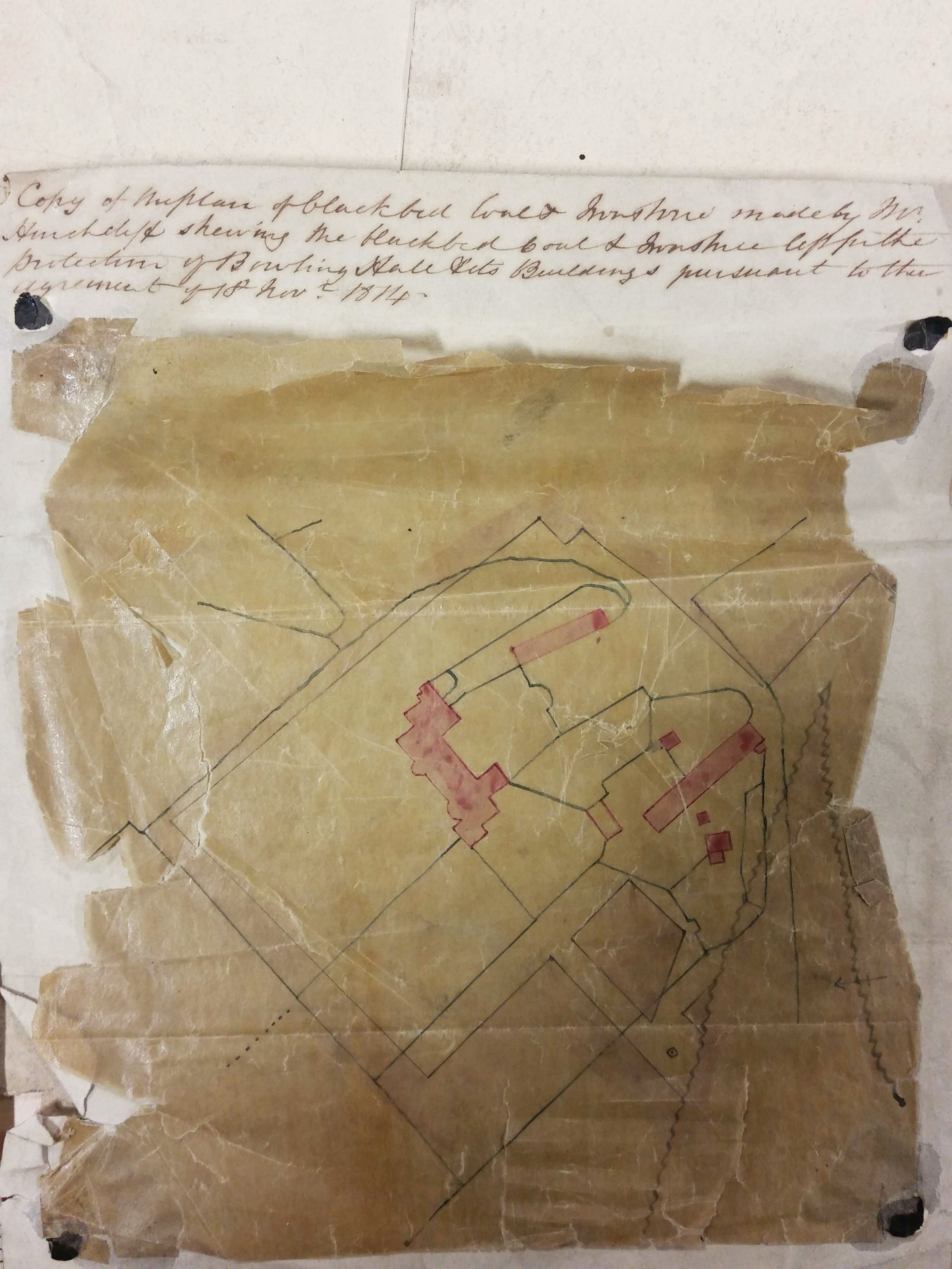
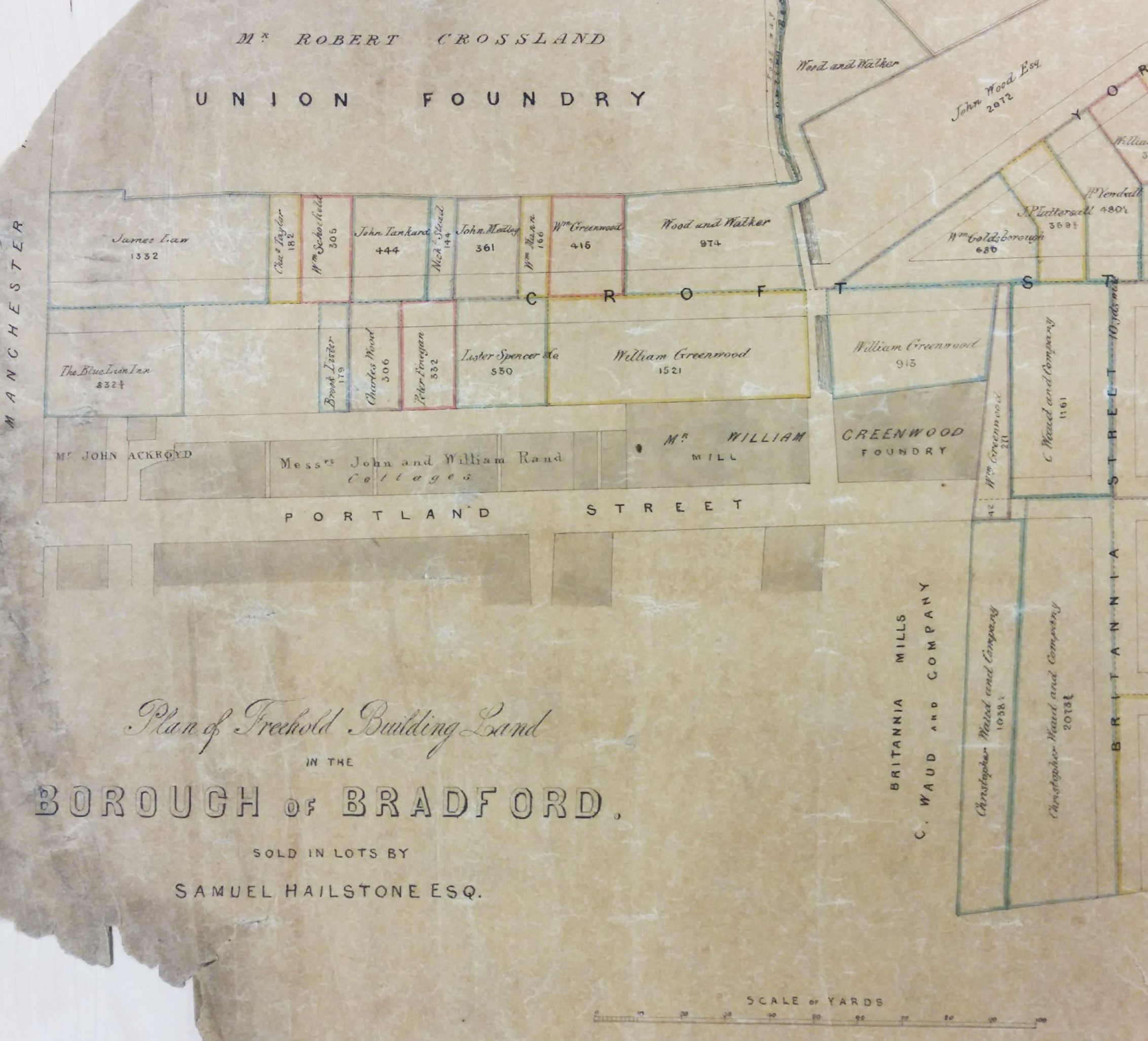
This brings us to the maps. In Samuel Hailstone 1837 he offered for sale the land between Croft Street & Bridge Street. A small portion of a very large sale plan is illustrated here.

Map of the Week 011A

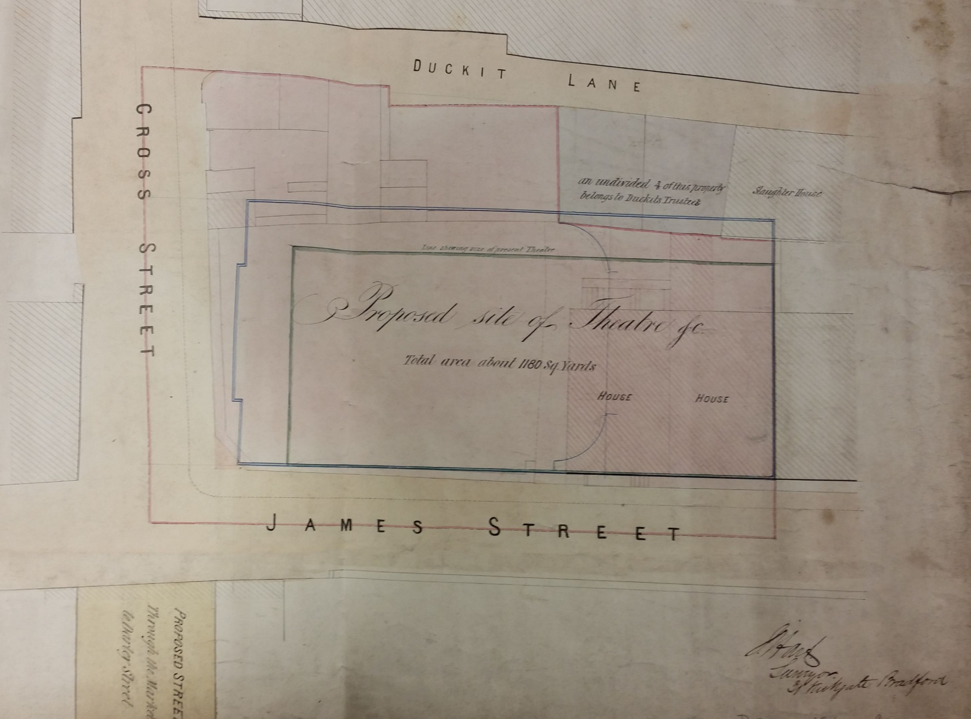
A second map shows land further south which is also divided into lots. This map is stylistically very similar and shows Samuel’s place of business and house. What is now called Croft Street took its name from Croft House, in Bowling Lane (now Manchester Road) which was was where Samuel lived in his early years.

Map of the Week 011B

In 1808, quite late in life, Samuel married Ann Jones, the daughter of a Bradford surgeon, and the couple had several children.  Samuel died at Horton Hall, Bradford in 1851. In his census return for that year he indicates that he is living alone, except for a house-keeper and five servants.

The Hailstones were a very high achieving family. One son, Samuel jnr., was also a noted amateur naturalist and a collector of crustacea. He pre-deceased his father in 1841. There were two surviving sons, Rev John Hailstone (1810-1871), the vicar of Bottisham, Cambridgeshire, and Edward Hailstone FSA (1818-1890). Edward took over the Bradford legal practice but is famous for a huge assembly of books and documents relating to Yorkshire history, especially those of the Sharp family who were the previous owners of Horton Hall. This was the project of his retirement when he lived at Walton Hall, near Wakefield. At his death the collection was left to the archives of York Minster where it can still be consulted today.

Derek Barker, Local Studies Library Volunteer

‘The Battle of the Somme continues’

Bradford Libraries's avatarBradford Libraries World War One Blog

A World War One event will take place at Bradford Local Studies Library on Saturday 3rd September.

The event will feature a talk about Bradford men in the Battle of the Somme and will be accompanied by an exhibition by the Bradford World War One Group.

Tricia Platts from the group and author of ‘Bradford in the Great War’ will be giving the talk from 11.00am until 12noon.

The battle of the Somme was one of the bloodiest of World War One. After the first and bloodiest day, the troops continued to press their advance. As the Pals battalions were mourned at home, the battle raged on.

Exactly 100 years ago, on 3 September 1916, the Bradford Territorials were engaged in a heavy battle below the Thiepval Ridge. Since their attack on 1 July these Bradford men had remained in the same area and, under constant fire, they had suffered many casualties.

Somme Continues“. …

View original post 63 more words

Map of the week: A Bolling Hall mineral plan

Maps and plans offer one of the best ways of reconstructing Bradford’s industrial history. Recently I found a 200 year old example at the Local Studies Library which was highly relevant to the history of the Bolling Hall estate. Victorian hand-writing is not always easy to read but, with small adjustments to spelling and capitalisation, the plan is headed: ‘Copy of the plan of Black Bed coal and ironstone made by Mr Hinchcliffe showing the Black Bed coal left for the protection of Bolling Hall and its buildings pursuant to the agreement of 18th November 1814‘.

Map of the Week 010

The fragile plan is not easy to interpret. Pink blocks represent Bolling Hall and its attendant out-buildings. Many of the black lines are property and field boundaries. Some of these make sense today, others presumably delineate parcels of land associated with the out-buildings. This whole central area is slightly paler in colour than the region outside the precinct boundary, which is darker and I assume represents winnable coal. This is most apparent if you start at the house and continue towards the bottom right of the plan. The wavy line, in an inverted V shape to the right, is probably a geological fault. In his description of the area historian William Cudworth reported a Bolling Hall fault which threw minerals ‘down 28 yards to the south’.

Bolling Hall is a Grade 1 listed building given by the last owner, Mr GA Paley, to the City of Bradford in 1912. The gift was associated with the purchase of land for nearby Bolling Girls High School, now demolished. A good deal of refurbishment has been undertaken since, including the creation of some formal gardens facing the entrance. Architecturally the hall is complex. A medieval pele tower at the south-west front contains the modern entrance and is believed to date from c1370. The south-east front Georgian bay was created in 1779-80 and (with its sash windows) contrasts sharply with the 17th century masonry present elsewhere. Historically the building is associated with two important families, the Bollings and the Tempests, but who occupied the hall at the time of this plan?

Towards the end of the 18th century the owner was Captain Sir Charles Wood, a Royal Navy officer, a painting of whom is still displayed on the main staircase. Captain Wood died of wounds in the far east and was succeeded by his son Sir Francis Lindley Wood (1771-1846). In 1794 Sir Francis gave the nearby Bowling Iron Company permission to mine coal and iron ore under his whole estate. Both as a land-owner and Lord of the Manor of Bowling Sir Francis controlled access to an immensely profitable asset. After five years he evidently grew tired of being surrounded by mines and spoil tips, however rich they made him, and he moved to another of his houses, Hemsworth Hall near Barnsley. Bolling Hall and its estate was sold outright to the BIC in 1816 and was allotted to its partners. Thomas Mason had it until 1834 then it passed to J G Paley. It remained in the possession of the Paley family until gifted to the City.

BIC had been established in 1780. It smelted iron ore found in the roof of the Black Bed coal seam, both of these minerals being mentioned in the plan rubric. A deeper coal seam, the Better Bed, made sulphur and phosphorous-free coke which was ideal for iron smelting. This seam is not mentioned on this plan, nor is the shallower Crow Coal. The removal of the Black Bed and its ironstone naturally left a gap into which the overburden of rock could collapse, resulting in surface subsidence. The common practice was to leave pillars of minerals unmined to support the roof. Under especially sensitive areas, which included churches and the mine-owner’s house, no mining at all took place. To indicate such restraint must be the purpose of this plan.

Where were the nearest coal or ironstone mines? The first OS map of Bradford (1852) shows a line of ‘old pits’ both north and south of New Hey Lane (now Road). The  Bolling Hall mine may have been closer still. About half-way between the bottom right corner of the house and the bottom right corner of the map is a small square containing a dot. I’m sure this represents a coal shaft. How deep was it? Fortunately opposite the north gate of Bowling Park (at SE 1698 3157) was a colliery called Waterloo Pit. This is only a few hundred metres away from the hall itself and fortunately the depths of coal seams at this location are recorded on the British Geological Survey website. They are:

Crow Coal            9.8m

Black Bed           28.3m

Better Bed         63.1m

The hall is at the same altitude as the Waterloo Pit (150m above ODL) so I think we can be sure that in the region of the plan the Black Bed coal was being mined, or not as the case may be, at about 30m depth.

Both the Bowling and Low Moor Iron companies exploited the same seams of coal and iron ore which extended over the whole of south Bradford and the surrounding areas. Huge networks of tramways and mineral ways grew up to bring the precious substances to the coke ovens and blast furnaces. To charge a blast furnace you also needed limestone to help the slag to separate. In the first OS map, close to the railway line at Bowling junction, is a ‘limestone quarry’. If there were limestone bedrock at this point then it would be more than a kilometre buried, so clearly we are dealing with a surface glacial deposit. The extraction of erratic limestone boulders from glacial moraine is recognised elsewhere in the Bradford district.

We are left with the problem of who was Mr Hinchcliffe? The only contemporary man of this name mentioned by William Cudworth, or present in Baines’s 1822 Directory, was Joseph Hinchcliffe who was a well-known local schoolmaster. Could surveying have been one of his skills? But the surname is a common one and could be that of an unknown BIC employee. Eventually local iron ore was exhausted and when this plan was being drawn the iron industry in Bradford had only about a century of existence left. Ore could be brought by sea from more favourable reserves abroad but transport costs ensured that only shore based blast furnaces, like those at Scunthorpe, survived. A century later still the deep-mining of coal in the UK was completely finished. This situation would have been inconceivable to Mr Hinchcliffe in 1814, whoever he was.

Derek Barker, Local Studies Library Volunteer


Map of the Week – Holdsworth Street Mill

The Local Studies Library houses hundreds of maps and plans in its reserve collection. My role as a volunteer is to provide the library staff with a report on the nature and condition of this material within an acceptable time frame, perhaps a few years. Consequently I can spend a few minutes at most with each map, although I use articles like this to display items which really deserve more detailed study. This plan is neither named nor dated. We have to ask four questions: what was it, where was it, when was it, and whose was it? Other Local Studies Library resources help to provide some answers to these questions.

Map of the Week 009

Click on map to open in a new window

Clearly we have the integrated premises of a worsted manufacturer with a spinning mill and weaving shed, both provided with independent steam power. The cottages included would not have housed more than a tiny fraction of the workforce. Perhaps they were occupied by men whose permanent presence on-site was desirable, such as ostlers or night watchmen. A substantial warehouse is included, but there is no dye house. As was common practice woven pieces must have been sent to commission dyers. A counting house was essentially a works office. I was puzzled by the sizing room but it seems that warps were treated, or sized, to make them stronger.

Where was this mill sited? Canal Road and Valley Road are two long sides of a scalene triangle that meet near the city centre immediately west of the canal. Holdsworth Street was the shorter third side that completed the triangle. It still exists, approached from the small roundabout from which you drive to Forster Square Station, but demolition and road development has left no visible trace of these buildings. Holdsworth Street and the spinning mill are present on the first OS map of the area (1851). The weaving shown here is not in the arrangement recorded in the 1851 OS nor the Bradford tithe map. Is our map older, or more recent? A nearby land owner is evidently the Bradford Gas & Light Company which was founded in the 1820s. The area involved remained the site of the Bradford Gas works for many decades to come.

Notice that the mill is adjacent to the William Rouse estate. I have briefly researched the Rouse family. William Rouse snr. (1765-1843) was a worsted spinner and weaver. His company (Wm. Rouse & Son) appears in the 1822 Gazetteer of the West Riding located at ‘Canal Side’. In subsequent trade directories it is placed nearby at: Mill Street, Canal Road, North Brook Street and, in 1872, Holdsworth Street. I am not sure if the same mill was being referred to on each occasion since in the Factory Commission report (1833) data was collected from three Rouse Mills, the oldest at Canal Side being built in 1815. The company’s closest brush with history must have been in 1820-22 when Titus Salt spent two years with them ‘learning the trade’ under the direction of John Hammond (see Jack Reynolds, The Great Paternalist, 1983, p.46). Rouse must have produced worsted stuff in the years before wool-combing was mechanised. With his son John (1794-1838) he employed hundreds of hand-combers who worked for him producing the wool ‘tops’ needed for the worsted process. By the time of William’s death the writing was on the wall for the poorly paid hand-combers whose trade was effectively destroyed by mechanical combs in the 1850s. The business clearly continued despite its founder’s death and the changing technology.

The 1853 White’s Leeds & the Clothing District Directory mentions a William Rouse, spinner & manufacturer, of West Lodge, Great Horton Road. William Rouse jnr. (1809-1868) had evidently succeeded his father. In the 1851 census Rouse reported employing 400 combers, 100 boys, and 150 girls. He may not have been too hard an employer since, on a Saturday in September 1849, the Bradford Observer records a works trip to Clapham by special train. Some employees saw the famous caves and others played cricket. All enjoyed a good dinner, and were home by 10 pm. William Rouse jnr. did everything expected of a successful textile man: church warden 1847, town counsellor 1848, magistrate 1852, and Poor Law overseer in 1860. By 1861 he was living in Burley House, Burley with his wife, children and six servants. He died there in 1868.

By the time of the 1879 PO Bradford Directory Wm. Rouse & Sons are placed at North Brook Street Mills. North Brook Street joins Canal Road just north of our map.  North Brook Mills are mentioned in the book Yorkshire Textile Mills 1779-1930 (RCHME) but unfortunately they had already been demolished when the mill survey was undertaken in the early 1990s. The mill in the plan is present in the 25 inch OS map of 1891. It seems to be linked to the named North Brook Street Mill but the mill building was then a warehouse, and the weaving shed was divided up between a repository and an engineering shop.

Wm. Rouse & Sons is included in The Century’s Progress, an 1893 work of self-publicity produced for Yorkshire industries. This states that the company was run by John, Frank and Herbert Rouse, grandsons of William Rouse snr. It is said to have operated ‘a vast home and export trade’ and to have had 40,000 spindles and 900 workers. The entry describes the company occupying the ‘Old Mills’ and the ‘New Mills’ acquired half a century earlier, that is in the 1840s. It states that the New Mills were in North Brook Street. I imagine that at some stage the company had created the premises illustrated in the plan but I am not sure if it was ‘Old’ or ‘New’. Can anyone help me?

Derek Barker, Local Studies Library Volunteer


Map of the Week – Coliseum Theatre

This map from the Local Studies Library reserve collection would seem to be the plan of a theatre or music hall drawn up prior to its enlargement. When I first saw it I recognised the location, between Duckett Lane and James Street, (which connect Godwin Street and John Street) but I could not see how a theatre could ever have been positioned there.  I could not then have named a single Bradford theatre besides the Alhambra and the Star Music Hall. The Star had an important role during the great Manningham Mills strike of 1890/91 when its lessee, a Mr Pullan, placed his premises at the disposal of the strike committee during the early days of the dispute. In Charles Dickens’s rather neglected novel Hard Times Mr Sleary, a circus manager, says: ‘People must be amused…they can’t be always a working, nor yet they can’t be always a learning’. So, how were they amused in Bradford? In the late eighteenth and early nineteenth centuries itinerant entertainers visited public houses, and there were also visits from fairs and circuses. It appears that permanent theatre building had commenced by the 1840s.

Map of the Week 008

The theatre in this plan was placed near Westgate and in 1849 Henry Pullan is known to have built the Coliseum Theatre ‘off Westgate’. However I cannot be sure that this map is actually of the Coliseum Theatre. Pullan had previously managed the Bermondsey Saloon in Cannon Street, a noted place of entertainment. His Coliseum was unusual in that it was not directly linked to a public house. Twenty years later he moved to a new theatre called Pullan’s ‘New’ Music Hall, Brunswick Place (now Rawson Street, by the multi-storey car park). This had an amazing 3,000 seats; the modern Alhambra has less than half that number. Pullen’s new musical hall remained in existence in the years 1869-89 at the end of which time it burned down. The vacant site left after the fire eventually evolved into John Street open market. Thomas Pullen and his son seem later to have taken over as managers of the Prince’s theatre and Star Music Hall, which brings us back to the Manningham Mills strike.

Although this plan was not dated it does mention St George’s Hall (opened 1853) and the New Exchange assembly rooms (foundation stone laid 1864), so presumably it was drawn after 1865. It seems plausible that it represented an intention to enlarge the old Coliseum theatre around 1868 although in the end a wholly new building was constructed on a nearby site. The older theatre evidently survived, being later renamed as St James’s Hall and then The Protestant Working Men’s Hall. It was finally demolished in 1892. This is a plausible date for the construction of the Commercial Inn still standing in James Street. This certainly looks like a late Victorian building.

The Coliseum was not Bradford’s first theatre which is said to have been owned by an L.S. Thompson in a converted barn on Southgate (now Sackville Street) around 1810-25. This hosted travelling theatre troops. A few years later, in 1841, the New Theatre opened at the city end of Thornton Road using the upper room in an existing Oddfellows Hall which had been opened in 1839. The Oddfellows were a friendly society who had 39 branches in Bradford and surrounding areas. I understand that the New Theatre was intended to hold ‘superior performances’. In the same year the Liver Theatre, Duke Street, became Bradford’s first purpose built theatrical premises. In 1844 it was remodelled and re-opened as Theatre Royal, Duke Street. The fact that it was widely known as the ‘wooden box’ may say something about the standards of its construction but in illustrations it looks stable enough. In 1864 the Alexandra Theatre had opened in Manningham Lane but in 1869, when the original Theatre Royal finally found fell victim to a series of street improvements, the Alexandra took over its discarded name. The Theatre Royal’s moment of fame occurred in 1905 when the great actor Sir Henry Irving gave his final performance as Thomas Becket on its stage. Shortly afterwards he collapsed and died in Bradford’s Midland Hotel.

In 1876 the Prince’s Theatre was built above Star Music Hall in Victoria Square. The proprietor of this curious double establishment was entrepreneur William Morgan who started his career as a Bradford hand wool-comber and concluded it as mayor of Scarborough. I think its site is the garden that is now in front of the Media Museum. Both theatres were fire damaged and restored in 1878. The Star Music Hall was renamed as Palace Theatre in 1890s and finally demolished in the 1960s. In 1899 the Empire Theatre was built at the end of Great Horton Road. All three theatres were just across the road from the present Alhambra which was built in 1914 and is associated with the name of Bradford’s pantomime king, Francis Laidler. In 1930 the New Victoria was opened on an adjacent site but this was eventually converted to the iconic Odeon Cinema. Finally I should mention that in 1837 the Jowett Temperance Hall had been built and this was also converted into a cinema as early as 1910. This building was also destroyed by fire and was rebuilt in 1937 as the Bradford Playhouse, Chapel Street.

If you would like a more detailed, and very well written, introduction to the subject of our theatres there is a splendid website:

http://www.arthurlloyd.co.uk/BradfordTheatresIndex.htm

A long account of the theatres is given in William Scruton’s Pen & Pencil Pictures of Old Bradford. Scruton provides many details of the largely forgotten actors who performed in Bradford. More recently the development of the early theatre was described by David Russell in The Pursuit of Leisure (in Victorian Bradford, 1982).

Derek Barker, Local Studies Library Volunteer